
Brazoria County, Texas
Brazoria County drilling permits: what the state recorded
- 21drilling permits
- 44completions
- 1first-production report
- in the last twelve months
Wells by coordinates
Oil wells and drilling locations in Brazoria County
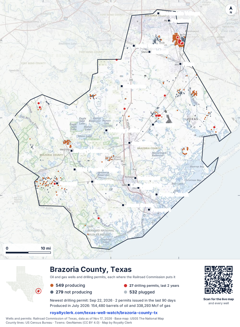
- Drilling locations27Permits issued in the last two years
- Producing wells549On a lease reporting production now
- Not producing279Shut in, inactive or no lease on record
- Plugged532The state's wellbore record says plugged
Sources: Railroad Commission of Texas well layers and permit files, US Census Bureau county outline, town points from GeoNames (CC BY 4.0), base map from USGS The National Map. A dot is a surface location; a horizontal well runs a mile or more from it.
1,360 wells with a location on the state's map and 27 drilling locations permitted in the last 24 months, each where the Railroad Commission puts it.
A permit is not a well.
Wells near each town in Brazoria County
- Alvin858 wells
- Angleton101 wells
- Brazoria145 wells
- Brookside Village1,244 wells
- Clute16 wells
- Danbury135 wells
- Freeport5 wells
- Holiday Lakes251 wells
- Iowa Colony1,164 wells
- Jones Creek20 wells
- Lake Jackson29 wells
- Manvel757 wells
- Oyster Creek5 wells
- Pearland1,107 wells
- Richwood20 wells
- Rosharon363 wells
- Sweeny329 wells
- West Columbia302 wells
- Wild Peach Village310 wells
Wells within 10 miles of each town, on either side of the county line.
Use this map on your site
You may show this map on any site, unchanged. Keep the credit line and its link to Royalty Clerk under the map. The picture updates by itself as the state records new wells and permits.
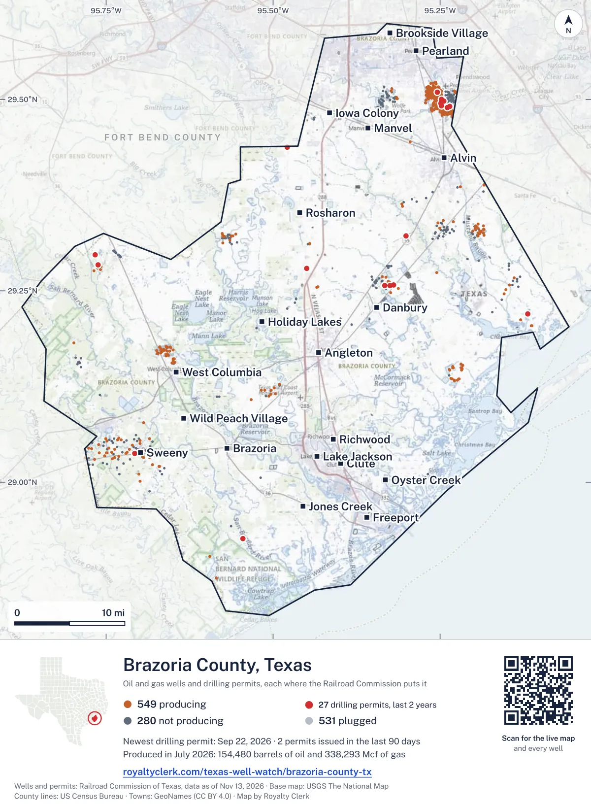
<a href="https://royaltyclerk.com/texas-well-watch/brazoria-county-tx"><img src="https://royaltyclerk.com/maps/county-wells/brazoria-county-tx.svg" alt="Map of Brazoria County, Texas, with 1,360 oil and gas wells and 27 recent drilling locations as dots." width="1000" height="1365" loading="lazy" style="max-width:100%;height:auto;border:0"></a>
<p style="margin:4px 0 0;font-size:14px">Map: <a href="https://royaltyclerk.com/texas-well-watch/brazoria-county-tx">Brazoria County, Texas oil and gas wells</a> by Royalty Clerk, from Railroad Commission of Texas records</p>
The last twelve months
Month by month in Brazoria County
| Month | Permits | Completions | First production |
|---|---|---|---|
| Oct 2026 | 0 | 1 | 0 |
| Sep 2026 | 2 | 0 | 0 |
| Aug 2026 | 2 | 7 | 0 |
| Jul 2026 | 0 | 3 | 0 |
| Jun 2026 | 10 | 3 | 0 |
| May 2026 | 0 | 7 | 0 |
| Apr 2026 | 0 | 2 | 0 |
| Mar 2026 | 1 | 4 | 0 |
| Feb 2026 | 0 | 3 | 0 |
| Jan 2026 | 4 | 5 | 1 |
| Dec 2025 | 2 | 7 | 0 |
| Nov 2025 | 0 | 2 | 0 |
Counted from November 19, 2025 to October 3, 2026, so the first and last months are partial. Source: Railroad Commission of Texas data sets.
Free, no sign-in
The newest drilling permits in Brazoria County
| Issued | Lease and well | Operator | Drilling began | Depth, ft | API number | Coordinates | Permit |
|---|---|---|---|---|---|---|---|
| 2026-09-22 | BENNETT ESTATE 27new drill · verticalHG Operating LLCAPI 42-039-33397 · permit 091787729.25728, -95.324622,000 ft | HG Operating LLC | |||||
| 2026-09-04 | ELDER 1new drill · verticalChisos, Ltd.API 42-039-33398 · permit 091832129.29708, -95.766654,500 ft | Chisos, Ltd. | |||||
| 2026-08-05 | BLACKSTONE 369 1new drill · verticalCimarron Engineering, LLCAPI 42-039-33396 · permit 091754529.22016, -95.118565,500 ft | Cimarron Engineering, LLC | |||||
| 2026-08-04 | PERRY 1new drill · verticalChisos, Ltd.API 42-039-33395 · permit 091752329.28371, -95.762274,000 ft | Chisos, Ltd. | |||||
| 2026-06-22 | WEST HASTINGS UNIT 6938new drill · verticalDenbury Onshore, LLCAPI 42-039-33394 · permit 091658029.50010, -95.248266,380 ft | Denbury Onshore, LLC | |||||
| 2026-06-22 | WEST HASTINGS UNIT 6519new drill · verticalDenbury Onshore, LLCAPI 42-039-33393 · permit 091650629.50010, -95.248176,380 ft | Denbury Onshore, LLC | |||||
| 2026-06-22 | WEST HASTINGS UNIT 8140new drill · verticalDenbury Onshore, LLCAPI 42-039-33392 · permit 091650529.49177, -95.247836,314 ft | Denbury Onshore, LLC | |||||
| 2026-06-22 | WEST HASTINGS UNIT 7929new drill · verticalDenbury Onshore, LLCAPI 42-039-33391 · permit 091650429.49177, -95.247736,380 ft | Denbury Onshore, LLC | |||||
| 2026-06-22 | WEST HASTINGS UNIT 8210new drill · verticalDenbury Onshore, LLCAPI 42-039-33390 · permit 091650329.49176, -95.247926,380 ft | Denbury Onshore, LLC | |||||
| 2026-06-22 | WEST HASTINGS UNIT 6939new drill · verticalDenbury Onshore, LLCAPI 42-039-33389 · permit 091650129.49499, -95.248656,380 ft | Denbury Onshore, LLC | |||||
| 2026-06-22 | WEST HASTINGS UNIT 7712new drill · verticalDenbury Onshore, LLCAPI 42-039-33388 · permit 091649929.49500, -95.248936,380 ft | Denbury Onshore, LLC | |||||
| 2026-06-19 | WEST HASTINGS UNIT 7931new drill · verticalDenbury Onshore, LLCAPI 42-039-33387 · permit 091649829.49500, -95.248746,244 ft | Denbury Onshore, LLC | |||||
| 2026-06-19 | WEST HASTINGS UNIT 7930new drill · verticalDenbury Onshore, LLCAPI 42-039-33386 · permit 091649729.49500, -95.248846,296 ft | Denbury Onshore, LLC | |||||
| 2026-06-19 | WEST HASTINGS UNIT 6817new drill · verticalDenbury Onshore, LLCAPI 42-039-33385 · permit 091649529.49499, -95.248556,312 ft | Denbury Onshore, LLC | |||||
| 2026-03-20 | DOROTHY ROBINSON 1new drill · verticalZachry Exploration, LLCAPI 42-039-33384 · permit 091421829.43760, -95.47900drilling began 2026-04-23 · 8,300 ft | Zachry Exploration, LLC | |||||
| 2026-01-14 | WEST HASTINGS UNIT 7804STrecompletion · verticalDenbury Onshore, LLCAPI 42-039-00669 · permit 091267129.49198, -95.247686,155 ft | Denbury Onshore, LLC | |||||
| 2026-01-14 | WEST HASTINGS UNIT 6910STrecompletion · verticalDenbury Onshore, LLCAPI 42-039-00656 · permit 091266129.49696, -95.247786,155 ft | Denbury Onshore, LLC | |||||
| 2026-01-14 | WEST HASTINGS UNIT 6702STrecompletion · verticalDenbury Onshore, LLCAPI 42-039-31306 · permit 091265729.49752, -95.244426,275 ft | Denbury Onshore, LLC | |||||
| 2026-01-14 | WEST HASTINGS UNIT 8124re-entry · verticalDenbury Onshore, LLCAPI 42-039-00737 · permit 091242729.48916, -95.23917drilling began 2026-08-18 · 5,705 ft | Denbury Onshore, LLC | |||||
| 2025-12-23 | WEST HASTING UNIT 8023re-entry · verticalDenbury Onshore, LLCAPI 42-039-00765 · permit 091242629.49105, -95.235917,509 ft | Denbury Onshore, LLC | |||||
| 2025-12-19 | WEST HASTINGS UNIT 3803recompletion · verticalDenbury Onshore, LLCAPI 42-039-31311 · permit 091211729.50958, -95.254136,300 ft | Denbury Onshore, LLC | |||||
| 2025-10-08 | BENNETT ESTATE 7recompletion · verticalHG Operating LLCAPI 42-039-32927 · permit 090635529.25755, -95.319378,860 ft | HG Operating LLC | |||||
| 2025-08-20 | OLD OCEAN UNIT 257recompletion · verticalHilcorp Energy CompanyAPI 42-039-33044 · permit 090959229.03759, -95.70698drilling began 2010-06-07 · 12,403 ft | Hilcorp Energy Company | |||||
| 2025-06-09 | BLACK STONE MINERALS 1new drill · verticalAssent Energy Partners, LLCAPI 42-039-33383 · permit 090845029.27965, -95.44971drilling began 2025-07-16 · 15,000 ft | Assent Energy Partners, LLC | |||||
| 2025-04-24 | REESE, J. T. 16 Anew drill · verticalYordes Energy, LLCAPI 42-039-33382 · permit 090697828.92636, -95.54547drilling began 2025-08-08 · 5,000 ft | Yordes Energy, LLC | |||||
| 2025-02-28 | ROWAN ALLAR 1new drill · verticalCimarron Engineering, LLCAPI 42-039-33381 · permit 090624829.32142, -95.30142drilling began 2025-03-05 · 9,400 ft | Cimarron Engineering, LLC | |||||
| 2024-11-25 | BENNETT ESTATE 21recompletion · verticalHG Operating LLCAPI 42-039-33223 · permit 090312429.25699, -95.333183,000 ft | HG Operating LLC | |||||
| 2024-10-08 | BENNETT ESTATE 24recompletion · verticalHG Operating LLCAPI 42-039-33325 · permit 090312629.25998, -95.326242,311 ft | HG Operating LLC | |||||
| 2024-08-29 | E.J. FORCE 1Urecompletion · verticalGoldking Minerals Mgmt, L.L.C.API 42-039-31348 · permit 090115529.44445, -95.294589,006 ft | Goldking Minerals Mgmt, L.L.C. | |||||
| 2024-05-24 | BM-MOW-1 1new drill · verticalU.S. Department of EnergyAPI 42-039-33365 · permit 089858928.91327, -95.37888drilling began 2024-10-31 · 2,550 ft | U.S. Department of Energy | |||||
| 2024-05-23 | EAST HOGG 1new drill · verticalTag Operating Company, Inc.API 42-039-33380 · permit 089972829.16771, -95.64426drilling began 2025-08-24 · 6,550 ft | Tag Operating Company, Inc. | |||||
| 2024-05-02 | BENNETT ESTATE 3field transfer · verticalBXP Operating, LLCAPI 42-039-32818 · permit 089776129.25914, -95.32831drilling began 2017-12-15 · 9,153 ft | BXP Operating, LLC | |||||
| 2024-04-16 | ONYX 1new drill · verticalAgeron Energy, LLCAPI 42-039-33379 · permit 089878129.23356, -95.13826drilling began 2024-06-11 · 6,000 ft | Ageron Energy, LLC | |||||
| 2024-03-12 | WIETING, A. M. 3recompletion · verticalWhite Marlin Operating Co, LLCAPI 42-039-00918 · permit 089797529.32472, -95.1912810,551 ft | White Marlin Operating Co, LLC | |||||
| 2024-01-26 | DAVID YOUNG 1Srecompletion · verticalElliott Oil & Gas Operating Co.API 42-039-33250 · permit 089668729.28569, -95.1468711,000 ft | Elliott Oil & Gas Operating Co. | |||||
| 2024-01-09 | H. BLACKSTONE 1recompletion · verticalCimarron Engineering, LLCAPI 42-039-33371 · permit 089636229.26263, -95.13487drilling began 2023-01-25 · 11,502 ft | Cimarron Engineering, LLC | |||||
| 2022-10-12 | COZBY 1recompletion · verticalElliott Oil & Gas Operating Co.API 42-039-00952 · permit 088465029.32293, -95.194659,704 ft | Elliott Oil & Gas Operating Co. | |||||
| 2022-04-04 | SCOUT 1REre-entry · verticalAspect Energy, LLCAPI 42-039-33204 · permit 087317829.48137, -95.40448drilling began 2022-08-31 · 11,000 ft | Aspect Energy, LLC |
A permit is permission to drill, not a well. Source: Railroad Commission of Texas drilling permit files.
Year by year
Drilling permits issued in Brazoria County, by year
| Year | Permits issued |
|---|---|
| 2026 so far | 19 |
| 2025 | 7 |
| 2024 | 10 |
| 2022 | 2 |
Counted from the permit files we hold, which start in 2022; that first year may be partial. Source: Railroad Commission of Texas drilling permit files.
The latest
The most recent records
| Date | What, who and where |
|---|---|
| 2026-10-03 | Completed: Denbury Onshore, LLCWEST HASTING UNIT · A-349 |
| 2026-09-22 | Permit issued: HG Operating LLCBENNETT ESTATE · A-265 · permit 0917877 |
| 2026-09-04 | Permit issued: Chisos, Ltd.ELDER · A-61 · permit 0918321 |
| 2026-08-22 | Completed: Denbury Onshore, LLCWEST HASTING UNIT · A-462 |
| 2026-08-19 | Completed: Denbury Onshore, LLCWEST HASTING UNIT |
| 2026-08-15 | Completed: Denbury Onshore, LLCWEST HASTING UNIT |
| 2026-08-07 | Completed: Denbury Onshore, LLCWEST HASTING UNIT |
| 2026-08-05 | Permit issued: Cimarron Engineering, LLCBLACKSTONE 369 · A-369 · permit 0917545 |
| 2026-08-04 | Completed: Goldking Minerals Mgmt, L.L.C.E.J. FORCE · A-229 · permit 0901155 |
| 2026-08-04 | Permit issued: Chisos, Ltd.PERRY · A-61 · permit 0917523 |
| 2026-08-03 | Completed: Denbury Onshore, LLCWEST HASTING UNIT · A-292 |
| 2026-08-02 | Completed: Denbury Onshore, LLCWEST HASTING UNIT |
| 2026-07-25 | Completed: Denbury Onshore, LLCWEST HASTING UNIT |
| 2026-07-16 | CompletedA-142 |
| 2026-07-02 | Completed: Denbury Onshore, LLCWEST HASTING UNIT |
Coming up
First checks coming due in Brazoria County
- WEST HASTING UNIT, Denbury Onshore, LLCby November 28, 2026
- WEST HASTING UNIT, Denbury Onshore, LLCby November 28, 2026
- WEST HASTING UNIT, Denbury Onshore, LLCby December 29, 2026
- WEST HASTING UNIT, Denbury Onshore, LLCby December 29, 2026
- WEST HASTING UNIT, Denbury Onshore, LLCby December 29, 2026
- WEST HASTING UNIT, Denbury Onshore, LLCby December 29, 2026
- WEST HASTING UNIT, Denbury Onshore, LLCby December 29, 2026
- WEST HASTING UNIT, Denbury Onshore, LLCby December 29, 2026
Follow it
Watch Brazoria County, or one abstract
What do you want to follow?
Where the land is. Your deed or lease names it.
For example A-1119, or Bush, or T&P 38. Your deed or the tax bill has it.
Other counties
Drilling activity in other counties
Related
Related
- ToolTexas well watchPermit, completion, first production and when the first check is due.
- ToolIs this buyout offer fair?The offer as months of your income, what the acres mean, and the questions to ask.
- ToolIs this lease offer good?Bonus and royalty against the county, and a scan of the lease's clauses.
- Texas dataTexas operator changesWho took over whose leases in the last 24 months.
- ToolLate payment interestDeadlines and the interest a late payment earns.
- Texas dataTexas oil and gas atlas254 counties, every lease, operator and field.
FAQ
Questions people ask
How many wells were permitted in Brazoria County in the last year?
The Railroad Commission issued 21 drilling permits in Brazoria County in the twelve months to October 3, 2026, and recorded 44 completions and 1 first-production report. A permit is permission to drill, not a well.
How do I get an alert when a permit is issued near my land in Brazoria County?
Choose your abstract on this page, or the whole county, and sign in. You get one email a week, only when something new is recorded after you sign up. The alert says whether an event is on an interest in your Mineral File, on a place you follow, or only nearby.
When is my first royalty check due after a new well?
Natural Resources Code section 91.402(a) says on or before 120 days after the end of the month of first sale of production from the well. The state's first-production month is the closest public marker, so the date on this page is the earliest, not a certainty.
Got a new well on your land?
The first check is due within 120 days after the end of the month of first sale.
Sources
Primary sources, opened on 29 September 2026. Statute text is the current version on statutes.capitol.texas.gov.