
Chambers County, Texas
Chambers County drilling permits: what the state recorded
- 4drilling permits
- 21completions
- 3first-production reports
- in the last twelve months
Wells by coordinates
Oil wells and drilling locations in Chambers County
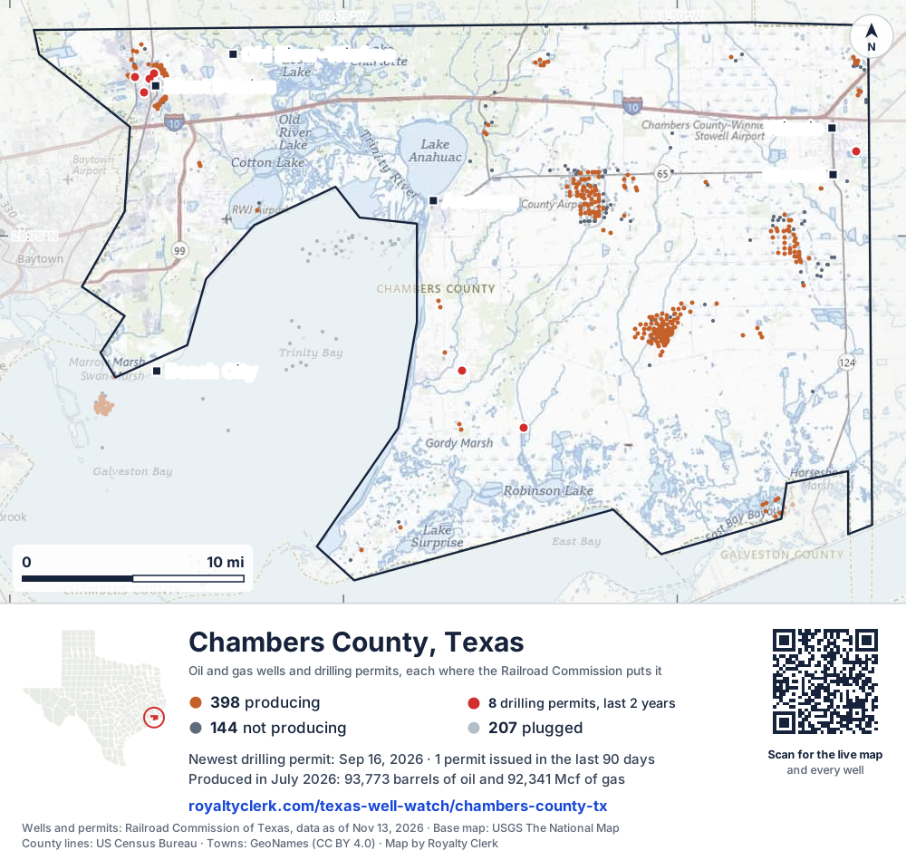
- Drilling locations8Permits issued in the last two years
- Producing wells398On a lease reporting production now
- Not producing144Shut in, inactive or no lease on record
- Plugged207The state's wellbore record says plugged
Sources: Railroad Commission of Texas well layers and permit files, US Census Bureau county outline, town points from GeoNames (CC BY 4.0), base map from USGS The National Map. A dot is a surface location; a horizontal well runs a mile or more from it.
749 wells with a location on the state's map and 8 drilling locations permitted in the last 24 months, each where the Railroad Commission puts it.
A permit is not a well.
Wells near each town in Chambers County
- Anahuac284 wells
- Beach City372 wells
- Mont Belvieu603 wells
- Old River-Winfree386 wells
- Stowell338 wells
- Winnie313 wells
Wells within 10 miles of each town, on either side of the county line.
Use this map on your site
You may show this map on any site, unchanged. Keep the credit line and its link to Royalty Clerk under the map. The picture updates by itself as the state records new wells and permits.
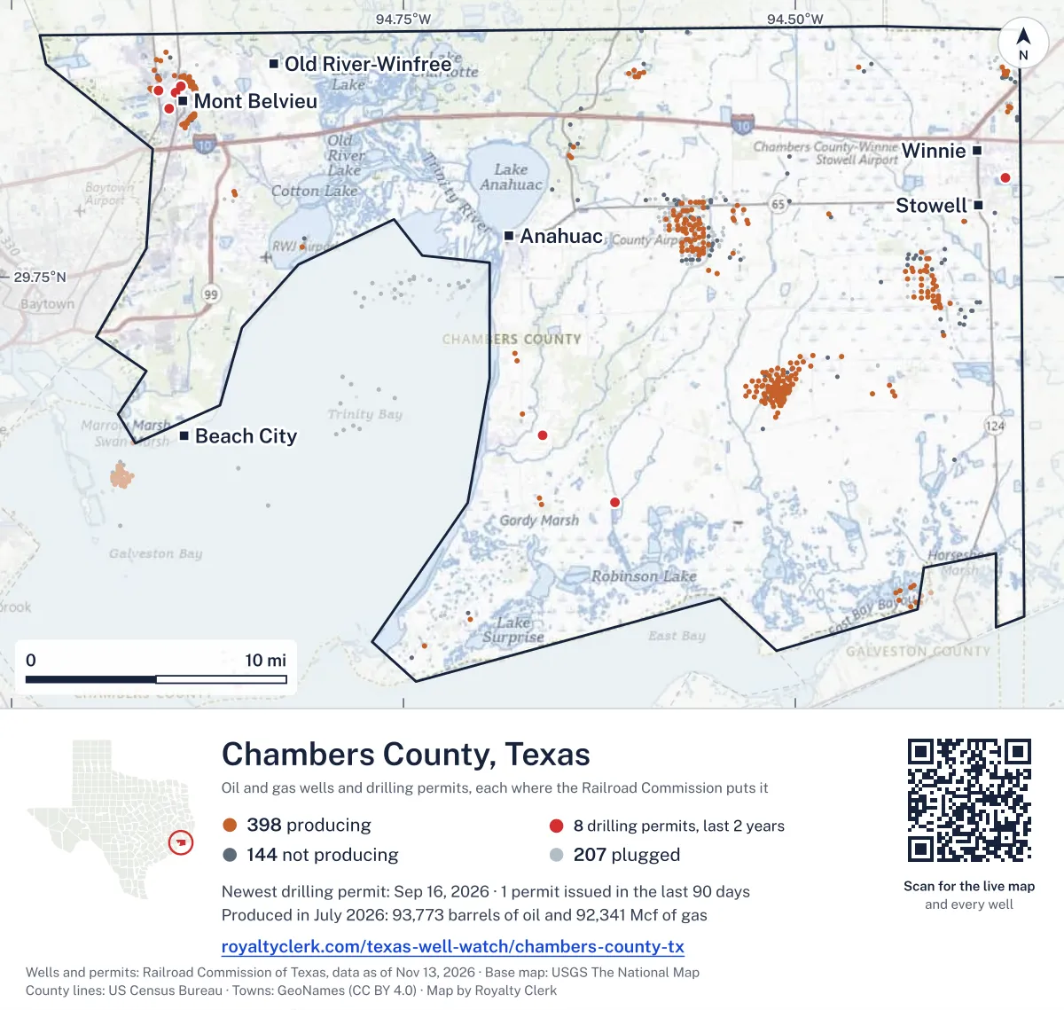
<a href="https://royaltyclerk.com/texas-well-watch/chambers-county-tx"><img src="https://royaltyclerk.com/maps/county-wells/chambers-county-tx.svg" alt="Map of Chambers County, Texas, with 749 oil and gas wells and 8 recent drilling locations as dots." width="1000" height="949" loading="lazy" style="max-width:100%;height:auto;border:0"></a>
<p style="margin:4px 0 0;font-size:14px">Map: <a href="https://royaltyclerk.com/texas-well-watch/chambers-county-tx">Chambers County, Texas oil and gas wells</a> by Royalty Clerk, from Railroad Commission of Texas records</p>
The last twelve months
Month by month in Chambers County
| Month | Permits | Completions | First production |
|---|---|---|---|
| Sep 2026 | 1 | 1 | 0 |
| Aug 2026 | 0 | 0 | 1 |
| Jul 2026 | 0 | 3 | 0 |
| Jun 2026 | 0 | 2 | 0 |
| May 2026 | 0 | 2 | 0 |
| Apr 2026 | 1 | 5 | 1 |
| Mar 2026 | 0 | 4 | 1 |
| Feb 2026 | 0 | 2 | 0 |
| Jan 2026 | 2 | 1 | 0 |
| Dec 2025 | 0 | 1 | 0 |
Counted from November 15, 2025 to September 17, 2026, so the first and last months are partial. Source: Railroad Commission of Texas data sets.
Free, no sign-in
The newest drilling permits in Chambers County
| Issued | Lease and well | Operator | Drilling began | Depth, ft | API number | Coordinates | Permit |
|---|---|---|---|---|---|---|---|
| 2026-09-16 | BARROW 1new drill · verticalKaler Energy Corp.API 42-071-32684 · permit 091863929.62532, -94.6152115,550 ft | Kaler Energy Corp. | |||||
| 2026-04-15 | RFR FRIO 15 GU 1recompletion · verticalGulf Resource Recovery Corp.API 42-071-32270 · permit 091463729.52434, -94.8556213,830 ft | Gulf Resource Recovery Corp. | |||||
| 2026-01-07 | LOPEZ 1new drill · verticalZachry Exploration, LLCAPI 42-071-32683 · permit 091235929.80484, -94.36612drilling began 2026-01-18 · 9,950 ft | Zachry Exploration, LLC | |||||
| 2026-01-06 | TURNER UNIT 1new drill · verticalMagnetar Operating LLCAPI 42-071-32682 · permit 091209529.66253, -94.66090drilling began 2026-02-01 · 11,600 ft | Magnetar Operating LLC | |||||
| 2025-09-17 | FEE 3Anew drill · verticalOneok Hydrocarbon Southwest, LLCAPI 42-071-32681 · permit 091036229.85559, -94.89222drilling began 2026-03-28 · 3,150 ft | Oneok Hydrocarbon Southwest, LLC | |||||
| 2025-05-16 | FEE 16Anew drill · verticalTarga Downstream LLCAPI 42-071-32680 · permit 090800529.84326, -94.89958drilling began 2025-05-17 · 3,288 ft | Targa Downstream LLC | |||||
| 2025-02-24 | CENTRAL STORAGE TERMINAL 3new drill · verticalMont Belvieu Caverns, LLCAPI 42-071-32679 · permit 090604929.85220, -94.89504drilling began 2025-02-25 · 7,600 ft | Mont Belvieu Caverns, LLC | |||||
| 2025-01-23 | LONE STAR NGL MB CENTRAL TERM 24NTnew drill · verticalEnergy Transfer Mt Belv Ngls LPAPI 42-071-32678 · permit 090536429.85322, -94.90621drilling began 2025-06-03 · 5,000 ft | Energy Transfer Mt Belv Ngls LP | |||||
| 2024-10-31 | LONE STAR NGL MB CENTRAL TERM 22NTnew drill · verticalEnergy Transfer Mt Belv Ngls LPAPI 42-071-32677 · permit 090371429.85258, -94.90465drilling began 2024-12-21 · 5,500 ft | Energy Transfer Mt Belv Ngls LP | |||||
| 2024-10-09 | BLUEBONNET USDW 8new drill · verticalBluebonnet Sequestration Hub, LLAPI 42-071-32676 · permit 090316029.84425, -94.45652drilling began 2025-05-10 · 2,950 ft | Bluebonnet Sequestration Hub, LL | |||||
| 2024-09-23 | CATHODIC PROTECTION 10new drill · verticalEnterprise Products OperatingllcAPI 42-071-32675 · permit 090280229.82170, -94.81263440 ft | Enterprise Products Operatingllc | |||||
| 2024-08-23 | CENTRAL STORAGE TERMINAL 2new drill · verticalMont Belvieu Caverns, LLCAPI 42-071-32674 · permit 090220929.85369, -94.89472drilling began 2024-09-27 · 7,600 ft | Mont Belvieu Caverns, LLC | |||||
| 2024-07-26 | MONT BELVIEU STORAGE 602new drill · verticalExxonmobil Pipeline Company LLCAPI 42-071-32673 · permit 090153729.84475, -94.90277drilling began 2024-08-03 · 3,470 ft | Exxonmobil Pipeline Company LLC | |||||
| 2024-04-17 | BLUEBONNET USDW 01new drill · verticalOXY Low Carbon Ventures, LLCAPI 42-071-32672 · permit 089878329.84425, -94.45689drilling began 2024-05-02 · 1,625 ft | OXY Low Carbon Ventures, LLC | |||||
| 2024-04-15 | MONT BELVIEU STORAGE 602new drill · verticalExxonmobil Pipeline Company LLCAPI 42-071-32671 · permit 089876829.84478, -94.90268drilling began 2024-07-07 · 3,470 ft | Exxonmobil Pipeline Company LLC | |||||
| 2024-02-22 | FEE 30new drill · verticalTarga Downstream LLCAPI 42-071-32670 · permit 089740729.84405, -94.90176drilling began 2024-02-25 · 5,500 ft | Targa Downstream LLC | |||||
| 2023-12-01 | WEAVER 1recompletion · verticalGaither Petroleum CorporationAPI 42-071-32381 · permit 089546729.88667, -94.598265,385 ft | Gaither Petroleum Corporation |
A permit is permission to drill, not a well. Source: Railroad Commission of Texas drilling permit files.
Year by year
Drilling permits issued in Chambers County, by year
| Year | Permits issued |
|---|---|
| 2026 so far | 4 |
| 2025 | 4 |
| 2024 | 8 |
| 2023 | 1 |
Counted from the permit files we hold, which start in 2023; that first year may be partial. Source: Railroad Commission of Texas drilling permit files.
The latest
The most recent records
| Date | What, who and where |
|---|---|
| 2026-09-17 | Completed: Mont Belvieu Caverns, LLCCENTRAL STORAGE TERMINAL · A-12 · permit 0906049 |
| 2026-09-16 | Permit issued: Kaler Energy Corp.BARROW · A-256 · permit 0918639 |
| 2026-08-01 | First production: Sandpoint Texas LLCWilburn "C" #9 |
| 2026-07-18 | Completed |
| 2026-07-07 | CompletedA-5 |
| 2026-07-07 | CompletedA-S |
| 2026-06-20 | Completed |
| 2026-06-13 | Completed: Mont Belvieu Caverns, LLCCENTRAL STORAGE TERMINAL · A-12 · permit 0906049 |
| 2026-05-28 | CompletedA-12 |
| 2026-05-11 | Completed |
| 2026-04-23 | Completed |
| 2026-04-22 | Completed |
| 2026-04-15 | Permit issued: Gulf Resource Recovery Corp.RFR FRIO 15 GU · permit 0914637 |
| 2026-04-10 | Completed |
| 2026-04-09 | Completed |
Coming up
First checks coming due in Chambers County
- Wilburn "C" #9, Sandpoint Texas LLCby December 29, 2026
Follow it
Watch Chambers County, or one abstract
What do you want to follow?
Where the land is. Your deed or lease names it.
For example A-1119, or Bush, or T&P 38. Your deed or the tax bill has it.
Other counties
Drilling activity in other counties
Related
Related
- ToolTexas well watchPermit, completion, first production and when the first check is due.
- ToolIs this buyout offer fair?The offer as months of your income, what the acres mean, and the questions to ask.
- ToolIs this lease offer good?Bonus and royalty against the county, and a scan of the lease's clauses.
- Texas dataTexas operator changesWho took over whose leases in the last 24 months.
- ToolLate payment interestDeadlines and the interest a late payment earns.
- Texas dataTexas oil and gas atlas254 counties, every lease, operator and field.
FAQ
Questions people ask
How many wells were permitted in Chambers County in the last year?
The Railroad Commission issued 4 drilling permits in Chambers County in the twelve months to September 17, 2026, and recorded 21 completions and 3 first-production reports. A permit is permission to drill, not a well.
How do I get an alert when a permit is issued near my land in Chambers County?
Choose your abstract on this page, or the whole county, and sign in. You get one email a week, only when something new is recorded after you sign up. The alert says whether an event is on an interest in your Mineral File, on a place you follow, or only nearby.
When is my first royalty check due after a new well?
Natural Resources Code section 91.402(a) says on or before 120 days after the end of the month of first sale of production from the well. The state's first-production month is the closest public marker, so the date on this page is the earliest, not a certainty.
Got a new well on your land?
The first check is due within 120 days after the end of the month of first sale.
Sources
Primary sources, opened on 29 September 2026. Statute text is the current version on statutes.capitol.texas.gov.