
Freestone County, Texas
Freestone County drilling permits: what the state recorded
- 33drilling permits
- 24completions
- 13first-production reports
- in the last twelve months
Wells by coordinates
Oil wells and drilling locations in Freestone County
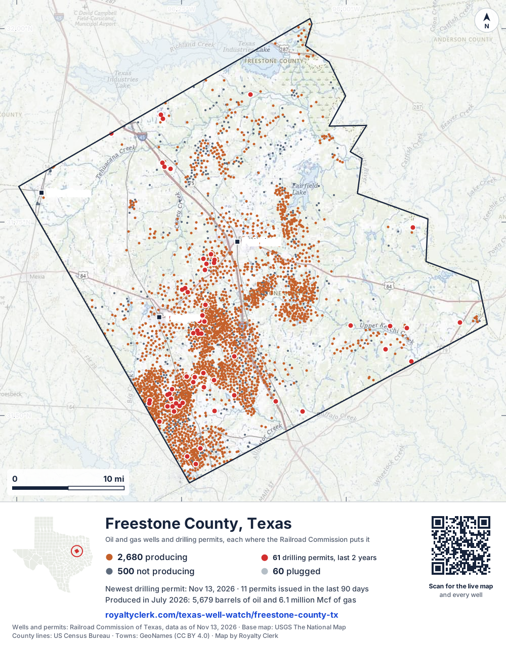
- Drilling locations60Permits issued in the last two years
- Producing wells2,680On a lease reporting production now
- Not producing500Shut in, inactive or no lease on record
- Plugged60The state's wellbore record says plugged
Sources: Railroad Commission of Texas well layers and permit files, US Census Bureau county outline, town points from GeoNames (CC BY 4.0), base map from USGS The National Map. A dot is a surface location; a horizontal well runs a mile or more from it.
3,240 wells with a location on the state's map and 60 drilling locations permitted in the last 24 months, each where the Railroad Commission puts it.
A permit is not a well.
Wells near each town in Freestone County
Wells within 10 miles of each town, on either side of the county line.
Use this map on your site
You may show this map on any site, unchanged. Keep the credit line and its link to Royalty Clerk under the map. The picture updates by itself as the state records new wells and permits.
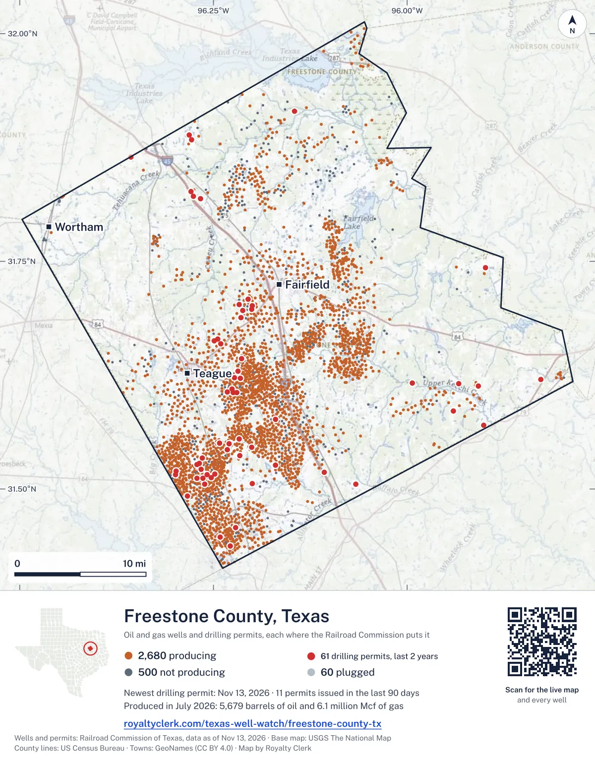
<a href="https://royaltyclerk.com/texas-well-watch/freestone-county-tx"><img src="https://royaltyclerk.com/maps/county-wells/freestone-county-tx.svg" alt="Map of Freestone County, Texas, with 3,240 oil and gas wells and 60 recent drilling locations as dots." width="1000" height="1276" loading="lazy" style="max-width:100%;height:auto;border:0"></a>
<p style="margin:4px 0 0;font-size:14px">Map: <a href="https://royaltyclerk.com/texas-well-watch/freestone-county-tx">Freestone County, Texas oil and gas wells</a> by Royalty Clerk, from Railroad Commission of Texas records</p>
The last twelve months
Month by month in Freestone County
| Month | Permits | Completions | First production |
|---|---|---|---|
| Nov 2026 | 2 | 0 | 0 |
| Oct 2026 | 3 | 0 | 0 |
| Sep 2026 | 4 | 0 | 0 |
| Aug 2026 | 2 | 0 | 2 |
| Jul 2026 | 6 | 4 | 0 |
| Jun 2026 | 3 | 1 | 0 |
| May 2026 | 2 | 3 | 2 |
| Apr 2026 | 0 | 5 | 2 |
| Mar 2026 | 4 | 3 | 0 |
| Feb 2026 | 2 | 4 | 2 |
| Jan 2026 | 2 | 2 | 3 |
| Dec 2025 | 3 | 2 | 2 |
Counted from November 16, 2025 to November 13, 2026, so the first and last months are partial. Source: Railroad Commission of Texas data sets.
Free, no sign-in
The newest drilling permits in Freestone County
| Issued | Lease and well | Operator | Drilling began | Depth, ft | API number | Coordinates | Permit |
|---|---|---|---|---|---|---|---|
| 2026-11-13 | CURRY GAS UNIT 8recompletion · verticalHilcorp Energy CompanyAPI 42-161-33065 · permit 091998531.64308, -96.2140612,540 ft | Hilcorp Energy Company | |||||
| 2026-11-09 | ROPER GAS UNIT 7recompletion · verticalHilcorp Energy CompanyAPI 42-161-34581 · permit 091997231.62829, -96.2681412,330 ft | Hilcorp Energy Company | |||||
| 2026-10-30 | LOCO HCX 1Hnew drill · verticalExpand Operating LLCAPI 42-161-34879 · permit 091959931.74316, -95.8987218,600 ft | Expand Operating LLC | |||||
| 2026-10-20 | HUGH D. WHITAKER GAS UNIT 1recompletion · verticalHilcorp Energy CompanyAPI 42-161-31145 · permit 091943331.45761, -96.221099,900 ft | Hilcorp Energy Company | |||||
| 2026-10-05 | WETTERMARK GAS UNIT 8recompletion · verticalHilcorp Energy CompanyAPI 42-161-34503 · permit 091901231.65968, -96.2402711,091 ft | Hilcorp Energy Company | |||||
| 2026-09-24 | HALE UNIT 4recompletion · verticalHilcorp Energy CompanyAPI 42-161-34295 · permit 091885131.66462, -96.2442113,100 ft | Hilcorp Energy Company | |||||
| 2026-09-21 | HALE UNIT 3recompletion · verticalHilcorp Energy CompanyAPI 42-161-33142 · permit 091877531.66281, -96.2491812,620 ft | Hilcorp Energy Company | |||||
| 2026-09-11 | WILLIAM C. GLAZENER G.U. 8recompletion · verticalHilcorp Energy CompanyAPI 42-161-31806 · permit 091848231.57661, -96.1697612,822 ft | Hilcorp Energy Company | |||||
| 2026-09-02 | HEGWARD STEBBINS 1Hnew drill · horizontalComstock Oil & Gas, LLCAPI 42-161-34878 · permit 091798331.61292, -95.9079330,000 ft | Comstock Oil & Gas, LLC | |||||
| 2026-08-21 | COLEMAN GAS UNIT 3recompletion · verticalHilcorp Energy CompanyAPI 42-161-32912 · permit 091798531.81884, -96.2664110,938 ft | Hilcorp Energy Company | |||||
| 2026-08-21 | DAUGHERTY GAS UNIT 1recompletion · verticalHilcorp Energy CompanyAPI 42-161-34062 · permit 091796631.91464, -96.1455012,065 ft | Hilcorp Energy Company | |||||
| 2026-07-29 | C. N. WILLIFORD 4recompletion · verticalHilcorp Energy CompanyAPI 42-161-31985 · permit 091736131.70827, -96.2049011,505 ft | Hilcorp Energy Company | |||||
| 2026-07-27 | NORTHEN GAS UNIT 11recompletion · verticalHilcorp Energy CompanyAPI 42-161-33221 · permit 091736031.70094, -96.2001812,325 ft | Hilcorp Energy Company | |||||
| 2026-07-16 | REED 'E' GAS UNIT 6recompletion · verticalHilcorp Energy CompanyAPI 42-161-32639 · permit 091717331.43740, -96.2280414,010 ft | Hilcorp Energy Company | |||||
| 2026-07-10 | BEST SWD 4recompletion · verticalHilcorp Energy CompanyAPI 42-161-31744 · permit 091702431.51846, -96.1067214,410 ft | Hilcorp Energy Company | |||||
| 2026-07-07 | NORTHEN GAS UNIT 14recompletion · verticalHilcorp Energy CompanyAPI 42-161-34063 · permit 091690431.69723, -96.2003312,318 ft | Hilcorp Energy Company | |||||
| 2026-07-01 | H. L. & P. GAS UNIT 17recompletion · verticalHilcorp Energy CompanyAPI 42-161-33308 · permit 091680731.44717, -96.2413814,300 ft | Hilcorp Energy Company | |||||
| 2026-06-16 | GILLIAM 'B' NO. 1 GAS UNIT 30recompletion · verticalHilcorp Energy CompanyAPI 42-161-34237 · permit 091640831.51971, -96.2982212,995 ft | Hilcorp Energy Company | |||||
| 2026-06-05 | GILLIAM 'B' NO. 1 GAS UNIT 14recompletion · verticalHilcorp Energy CompanyAPI 42-161-33250 · permit 091612031.51578, -96.2986412,920 ft | Hilcorp Energy Company | |||||
| 2026-06-01 | KNIGHT GAS UNIT NO. 1 2recompletion · verticalHilcorp Energy CompanyAPI 42-161-32395 · permit 091576431.55464, -96.2170213,105 ft | Hilcorp Energy Company | |||||
| 2026-05-08 | WEAVER DK 1Hnew drill · horizontalComstock Oil & Gas, LLCAPI 42-161-34877 · permit 091531631.61555, -95.93304drilling began 2026-07-21 · 30,000 ft | Comstock Oil & Gas, LLC | |||||
| 2026-05-01 | HUNT GAS UNIT NO. 3 5recompletion · verticalHilcorp Energy CompanyAPI 42-161-32972 · permit 091524131.52604, -96.1701414,100 ft | Hilcorp Energy Company | |||||
| 2026-03-19 | COCHRUM GAS UNIT 17recompletion · verticalHilcorp Energy CompanyAPI 42-161-34169 · permit 091413931.53411, -96.2647213,700 ft | Hilcorp Energy Company | |||||
| 2026-03-16 | COCHRUM GAS UNIT 16recompletion · verticalHilcorp Energy CompanyAPI 42-161-33840 · permit 091405631.52791, -96.26790drilling began 2026-03-02 · 13,500 ft | Hilcorp Energy Company | |||||
| 2026-03-06 | COLEMAN GAS UNIT 4recompletion · verticalHilcorp Energy CompanyAPI 42-161-33928 · permit 091385131.82139, -96.2757610,980 ft | Hilcorp Energy Company | |||||
| 2026-03-02 | FOREMAN 'B' NO. 1 GAS UNIT 14recompletion · verticalHilcorp Energy CompanyAPI 42-161-33885 · permit 091358331.52686, -96.2711713,190 ft | Hilcorp Energy Company | |||||
| 2026-02-26 | CANDY 2Dnew drill · verticalPumping Services, Inc.API 42-161-34876 · permit 091368131.62049, -95.82760drilling began 2026-03-30 · 6,000 ft | Pumping Services, Inc. | |||||
| 2026-02-04 | PILLANS OIL UNIT 1recompletion · verticalHilcorp Energy CompanyAPI 42-161-33462 · permit 091314731.88365, -96.2783310,703 ft | Hilcorp Energy Company | |||||
| 2026-01-21 | REED 'P' GAS UNIT NO. 1 14recompletion · verticalHilcorp Energy CompanyAPI 42-161-33915 · permit 091295731.49241, -96.2838013,160 ft | Hilcorp Energy Company | |||||
| 2026-01-21 | DOLLIE JONES RP 1Hnew drill · horizontalComstock Oil & Gas, LLCAPI 42-161-34875 · permit 091286631.61613, -95.9936630,000 ft | Comstock Oil & Gas, LLC | |||||
| 2025-12-23 | MCSWANE GAS UNIT 8recompletion · verticalHilcorp Energy CompanyAPI 42-161-33300 · permit 091237431.54984, -96.2300113,080 ft | Hilcorp Energy Company | |||||
| 2025-12-10 | L.E. BATY 2recompletion · verticalHilcorp Energy CompanyAPI 42-161-32797 · permit 091208731.53651, -96.21632drilling began 2005-04-23 · 13,316 ft | Hilcorp Energy Company | |||||
| 2025-12-05 | LOPER GAS UNIT 1recompletion · verticalHilcorp Energy CompanyAPI 42-161-32874 · permit 091204531.82645, -96.2789910,787 ft | Hilcorp Energy Company | |||||
| 2025-11-12 | EMERSON 1recompletion · verticalHilcorp Energy CompanyAPI 42-161-33199 · permit 091167731.88903, -96.2809910,695 ft | Hilcorp Energy Company | |||||
| 2025-10-21 | KNIGHT GAS UNIT 1 13recompletion · verticalHilcorp Energy CompanyAPI 42-161-33225 · permit 091122431.54582, -96.20050drilling began 2025-07-22 · 12,500 ft | Hilcorp Energy Company | |||||
| 2025-10-01 | KRETZSCHMAR PBH 1Hnew drill · horizontalComstock Oil & Gas, LLCAPI 42-161-34874 · permit 091066531.58579, -95.94068drilling began 2025-10-27 · 30,000 ft | Comstock Oil & Gas, LLC | |||||
| 2025-10-01 | KRETZSCHMAR PP 1Hnew drill · horizontalComstock Oil & Gas, LLCAPI 42-161-34873 · permit 091066431.58575, -95.94064drilling began 2025-10-27 · 30,000 ft | Comstock Oil & Gas, LLC | |||||
| 2025-09-12 | HUNT GAS UNIT NO. 2 3recompletion · verticalHilcorp Energy CompanyAPI 42-161-32200 · permit 091035131.50561, -96.2001112,900 ft | Hilcorp Energy Company | |||||
| 2025-09-09 | HAM GAS UNIT 31recompletion · verticalHilcorp Energy CompanyAPI 42-161-34545 · permit 091027531.62194, -96.22256drilling began 2010-09-10 · 10,857 ft | Hilcorp Energy Company | |||||
| 2025-09-08 | LIPSEY A 2Hnew drill · horizontalMitsui E&P USA LLCAPI 42-161-34872 · permit 091018331.57013, -95.90088drilling began 2025-09-11 · 30,000 ft | Mitsui E&P USA LLC | |||||
| 2025-08-06 | C.C. THOMPSON 25recompletion · verticalHilcorp Energy CompanyAPI 42-161-34086 · permit 090973331.51162, -96.2709813,113 ft | Hilcorp Energy Company | |||||
| 2025-07-29 | JOHN EPPES GAS UNIT NO. 1 6recompletion · verticalHilcorp Energy CompanyAPI 42-161-32974 · permit 090950431.54319, -96.2323413,050 ft | Hilcorp Energy Company | |||||
| 2025-07-29 | EAST HOUSTON TO CORSICANA 15new drill · verticalMagellan Crude Oil PL Co, L.P.API 42-161-34871 · permit 090389231.86462, -96.35680350 ft | Magellan Crude Oil PL Co, L.P. | |||||
| 2025-07-25 | JOHN EPPES GAS UNIT NO. 1 10recompletion · verticalHilcorp Energy CompanyAPI 42-161-33506 · permit 090945631.55048, -96.24192drilling began 2006-11-30 · 12,300 ft | Hilcorp Energy Company | |||||
| 2025-06-30 | C.C. THOMPSON 16recompletion · verticalHilcorp Energy CompanyAPI 42-161-32101 · permit 090885231.50551, -96.26145drilling began 2001-11-17 · 12,940 ft | Hilcorp Energy Company | |||||
| 2025-06-24 | J.M. POLLARD GAS UNIT 42recompletion · verticalHilcorp Energy CompanyAPI 42-161-34497 · permit 090880431.52179, -96.2661413,251 ft | Hilcorp Energy Company | |||||
| 2025-06-23 | C.A. NEWSOM ESTATE 23recompletion · verticalHilcorp Energy CompanyAPI 42-161-32308 · permit 090870831.51274, -96.2527812,880 ft | Hilcorp Energy Company | |||||
| 2025-06-12 | C.A. NEWSOM ESTATE 20recompletion · verticalHilcorp Energy CompanyAPI 42-161-31941 · permit 090852631.51167, -96.26365drilling began 2001-05-25 · 12,962 ft | Hilcorp Energy Company | |||||
| 2025-06-09 | C.A. NEWSOM ESTATE 40recompletion · verticalHilcorp Energy CompanyAPI 42-161-34632 · permit 090848131.51576, -96.2580212,944 ft | Hilcorp Energy Company | |||||
| 2025-06-09 | C.A. NEWSOM ESTATE 37recompletion · verticalHilcorp Energy CompanyAPI 42-161-34624 · permit 090847731.51612, -96.2485212,952 ft | Hilcorp Energy Company |
These are the newest 50 of 67 permits on file for Freestone County. The rest follow, 50 to a page.
A permit is permission to drill, not a well. Source: Railroad Commission of Texas drilling permit files.
Year by year
Drilling permits issued in Freestone County, by year
| Year | Permits issued |
|---|---|
| 2026 so far | 30 |
| 2025 | 29 |
| 2024 | 8 |
Counted from the permit files we hold, which start in 2024; that first year may be partial. Source: Railroad Commission of Texas drilling permit files.
The latest
The most recent records
| Date | What, who and where |
|---|---|
| 2026-11-13 | Permit issued: Hilcorp Energy CompanyCURRY GAS UNIT · A-351 · permit 0919985 |
| 2026-11-09 | Permit issued: Hilcorp Energy CompanyROPER GAS UNIT · A-130 · permit 0919972 |
| 2026-10-30 | Permit issued: Expand Operating LLCLOCO HCX · A-251 · permit 0919599 |
| 2026-10-20 | Permit issued: Hilcorp Energy CompanyHUGH D. WHITAKER GAS UNIT · A-178 · permit 0919433 |
| 2026-10-05 | Permit issued: Hilcorp Energy CompanyWETTERMARK GAS UNIT · A-556 · permit 0919012 |
| 2026-09-24 | Permit issued: Hilcorp Energy CompanyHALE UNIT · A-294 · permit 0918851 |
| 2026-09-21 | Permit issued: Hilcorp Energy CompanyHALE UNIT · A-179 · permit 0918775 |
| 2026-09-11 | Permit issued: Hilcorp Energy CompanyWILLIAM C. GLAZENER G.U. · A-3 · permit 0918482 |
| 2026-09-02 | Permit issued: Comstock Oil & Gas, LLCHEGWARD STEBBINS · A-19 · permit 0917983 |
| 2026-08-21 | Permit issued: Hilcorp Energy CompanyDAUGHERTY GAS UNIT · A-53 · permit 0917966 |
| 2026-08-21 | Permit issued: Hilcorp Energy CompanyCOLEMAN GAS UNIT · A-115 · permit 0917985 |
| 2026-08-01 | First production: Comstock Oil & Gas, LLCKretzschmar PBH · A-680 · permit 0910665 |
| 2026-08-01 | First production: Comstock Oil & Gas, LLCKretzschmar PP · A-680 · permit 0910664 |
| 2026-07-30 | Completed: Hilcorp Energy CompanyGILLIAM 'B' NO. 1 GAS UNIT · A-10 · permit 0916408 |
| 2026-07-29 | Completed: Hilcorp Energy CompanyNORTHEN GAS UNIT · A-23 · permit 0916904 |
Coming up
First checks coming due in Freestone County
- GILLIAM 'B' NO. 1 GAS UNIT, Hilcorp Energy Companyby November 28, 2026
- H. L. & P. GAS UNIT, Hilcorp Energy Companyby November 28, 2026
- GILLIAM 'B' NO. 1 GAS UNIT, Hilcorp Energy Companyby November 28, 2026
- NORTHEN GAS UNIT, Hilcorp Energy Companyby November 28, 2026
- Kretzschmar PP, Comstock Oil & Gas, LLCby December 29, 2026
- Kretzschmar PBH, Comstock Oil & Gas, LLCby December 29, 2026
Follow it
Watch Freestone County, or one abstract
What do you want to follow?
Where the land is. Your deed or lease names it.
For example A-1119, or Bush, or T&P 38. Your deed or the tax bill has it.
Other counties
Drilling activity in other counties
Related
Related
- ToolTexas well watchPermit, completion, first production and when the first check is due.
- ToolIs this buyout offer fair?The offer as months of your income, what the acres mean, and the questions to ask.
- ToolIs this lease offer good?Bonus and royalty against the county, and a scan of the lease's clauses.
- Texas dataTexas operator changesWho took over whose leases in the last 24 months.
- ToolLate payment interestDeadlines and the interest a late payment earns.
- Texas dataTexas oil and gas atlas254 counties, every lease, operator and field.
FAQ
Questions people ask
How many wells were permitted in Freestone County in the last year?
The Railroad Commission issued 33 drilling permits in Freestone County in the twelve months to November 13, 2026, and recorded 24 completions and 13 first-production reports. A permit is permission to drill, not a well.
How do I get an alert when a permit is issued near my land in Freestone County?
Choose your abstract on this page, or the whole county, and sign in. You get one email a week, only when something new is recorded after you sign up. The alert says whether an event is on an interest in your Mineral File, on a place you follow, or only nearby.
When is my first royalty check due after a new well?
Natural Resources Code section 91.402(a) says on or before 120 days after the end of the month of first sale of production from the well. The state's first-production month is the closest public marker, so the date on this page is the earliest, not a certainty.
Got a new well on your land?
The first check is due within 120 days after the end of the month of first sale.
Sources
Primary sources, opened on 29 September 2026. Statute text is the current version on statutes.capitol.texas.gov.