
Haskell County, Texas
Haskell County drilling permits: what the state recorded
- 12drilling permits
- 6completions
- 3first-production reports
- in the last twelve months
Wells by coordinates
Oil wells and drilling locations in Haskell County
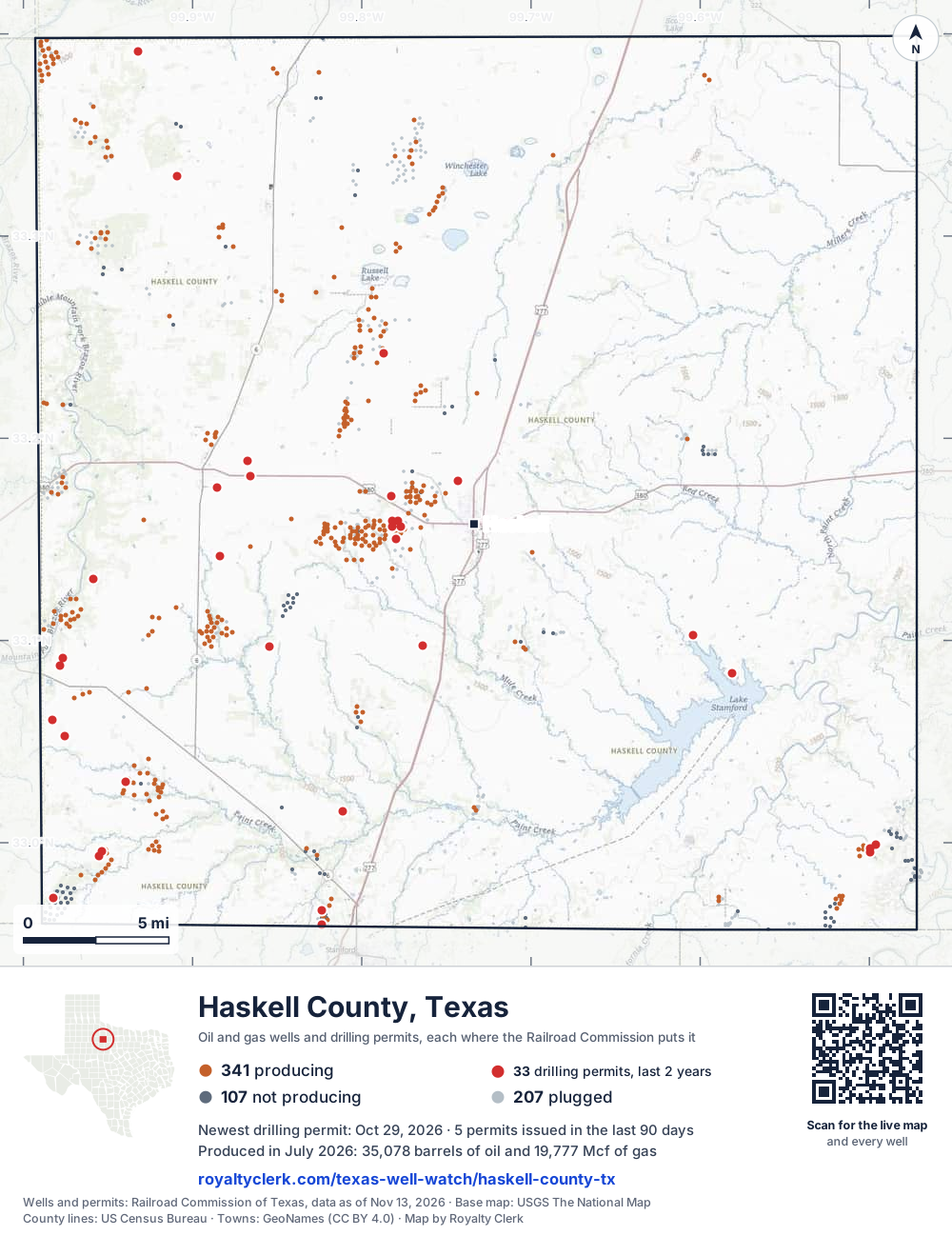
- Drilling locations33Permits issued in the last two years
- Producing wells341On a lease reporting production now
- Not producing107Shut in, inactive or no lease on record
- Plugged207The state's wellbore record says plugged
Sources: Railroad Commission of Texas well layers and permit files, US Census Bureau county outline, town points from GeoNames (CC BY 4.0), base map from USGS The National Map. A dot is a surface location; a horizontal well runs a mile or more from it.
655 wells with a location on the state's map and 33 drilling locations permitted in the last 24 months, each where the Railroad Commission puts it.
A permit is not a well.
Wells near each town in Haskell County
Wells within 10 miles of each town, on either side of the county line.
Use this map on your site
You may show this map on any site, unchanged. Keep the credit line and its link to Royalty Clerk under the map. The picture updates by itself as the state records new wells and permits.
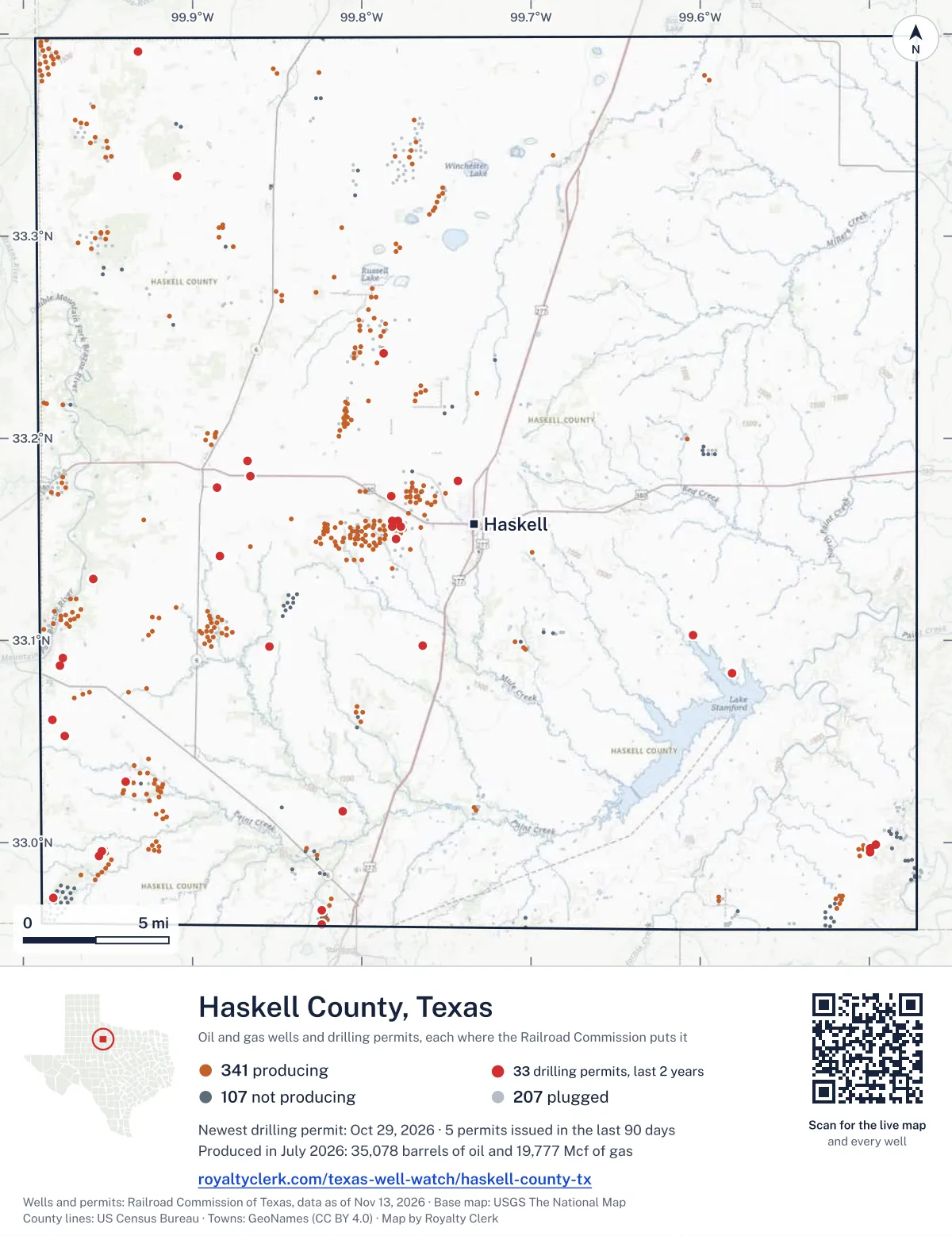
<a href="https://royaltyclerk.com/texas-well-watch/haskell-county-tx"><img src="https://royaltyclerk.com/maps/county-wells/haskell-county-tx.svg" alt="Map of Haskell County, Texas, with 655 oil and gas wells and 33 recent drilling locations as dots." width="1000" height="1298" loading="lazy" style="max-width:100%;height:auto;border:0"></a>
<p style="margin:4px 0 0;font-size:14px">Map: <a href="https://royaltyclerk.com/texas-well-watch/haskell-county-tx">Haskell County, Texas oil and gas wells</a> by Royalty Clerk, from Railroad Commission of Texas records</p>
The last twelve months
Month by month in Haskell County
| Month | Permits | Completions | First production |
|---|---|---|---|
| Oct 2026 | 1 | 0 | 0 |
| Sep 2026 | 3 | 0 | 0 |
| Aug 2026 | 4 | 1 | 1 |
| Jun 2026 | 0 | 1 | 0 |
| Apr 2026 | 2 | 0 | 0 |
| Mar 2026 | 0 | 1 | 1 |
| Feb 2026 | 0 | 1 | 1 |
| Jan 2026 | 0 | 1 | 0 |
| Dec 2025 | 2 | 0 | 0 |
| Nov 2025 | 0 | 1 | 0 |
Counted from November 15, 2025 to October 29, 2026, so the first and last months are partial. Source: Railroad Commission of Texas data sets.
Free, no sign-in
The newest drilling permits in Haskell County
| Issued | Lease and well | Operator | Drilling began | Depth, ft | API number | Coordinates | Permit |
|---|---|---|---|---|---|---|---|
| 2026-10-29 | SWENSON A 4new drill · verticalLandmaster Partners, Inc.API 42-207-33076 · permit 091976632.95931, -99.823542,999 ft | Landmaster Partners, Inc. | |||||
| 2026-09-23 | HENDRICK 103 2new drill · verticalBluff Creek Petroleum, LLCAPI 42-207-33075 · permit 091878332.99700, -99.499431,999 ft | Bluff Creek Petroleum, LLC | |||||
| 2026-09-03 | PACE 2new drill · verticalWilcox Petroleum Operating Llc.API 42-207-33074 · permit 091813333.15900, -99.781975,600 ft | Wilcox Petroleum Operating Llc. | |||||
| 2026-09-02 | WHALEN 4re-entry · verticalJQL Energy, LLCAPI 42-207-31132 · permit 091821933.03004, -99.939783,000 ft | JQL Energy, LLC | |||||
| 2026-08-26 | GOETZ 1new drill · verticalWilcox Petroleum Operating Llc.API 42-207-33073 · permit 091812633.15008, -99.779805,600 ft | Wilcox Petroleum Operating Llc. | |||||
| 2026-08-07 | BEARD 1new drill · verticalDelta Oil & Gas Ltd.API 42-207-33071 · permit 091762533.17558, -99.885586,000 ft | Delta Oil & Gas Ltd. | |||||
| 2026-08-07 | GRISHAM BREWER 1new drill · verticalDelta Oil & Gas Ltd.API 42-207-33070 · permit 091762433.14165, -99.883606,000 ft | Delta Oil & Gas Ltd. | |||||
| 2026-08-06 | BS-10 01new drill · verticalPlains Pipeline Midcon LLCAPI 42-207-33072 · permit 090985633.17159, -99.78286350 ft | Plains Pipeline Midcon LLC | |||||
| 2026-04-23 | PACE 1new drill · verticalWilcox Petroleum Operating Llc.API 42-207-33069 · permit 091501733.15893, -99.77888drilling began 2026-06-19 · 5,600 ft | Wilcox Petroleum Operating Llc. | |||||
| 2026-04-20 | TP #13 1new drill · verticalEnergy Transfer CompanyAPI 42-207-33068 · permit 091454433.09678, -99.85486400 ft | Energy Transfer Company | |||||
| 2025-12-22 | WOLF CREEK 1new drill · verticalBluff Creek Petroleum, LLCAPI 42-207-33067 · permit 091235632.99900, -99.49601drilling began 2026-01-10 · 3,999 ft | Bluff Creek Petroleum, LLC | |||||
| 2025-12-02 | HIGHFALUTIN 1new drill · verticalTrio Consulting & Management,llcAPI 42-207-33066 · permit 091181533.09147, -99.97644drilling began 2025-12-14 · 5,500 ft | Trio Consulting & Management,llc | |||||
| 2025-09-04 | CAHILL 7new drill · verticalWilcox Petroleum Operating Llc.API 42-207-33065 · permit 091020033.15634, -99.77722drilling began 2025-10-10 · 6,000 ft | Wilcox Petroleum Operating Llc. | |||||
| 2025-08-22 | HENDRICK 103 1new drill · verticalBluff Creek Petroleum, LLCAPI 42-207-33064 · permit 090999532.99535, -99.49942drilling began 2025-09-11 · 1,999 ft | Bluff Creek Petroleum, LLC | |||||
| 2025-08-05 | NOLA JAN 1new drill · verticalS.b. Street Operating, Inc.API 42-207-33063 · permit 090965133.24224, -99.78727drilling began 2025-08-18 · 4,999 ft | S.b. Street Operating, Inc. | |||||
| 2025-07-23 | FLAT TOP STRAWN UNIT 61new drill · verticalNBX Energy, LLCAPI 42-207-33062 · permit 090937232.97280, -99.98239drilling began 2025-07-30 · 5,500 ft | NBX Energy, LLC | |||||
| 2025-07-15 | FLAT TOP RANCH PCN 18new drill · verticalNBX Energy, LLCAPI 42-207-33061 · permit 090924432.99338, -99.95508drilling began 2025-07-20 · 6,500 ft | NBX Energy, LLC | |||||
| 2025-06-25 | TP 15.65 2new drill · verticalEnergy Transfer CompanyAPI 42-207-33060 · permit 090876233.32985, -99.90904400 ft | Energy Transfer Company | |||||
| 2025-06-24 | TP 15.85 2new drill · verticalEnergy Transfer CompanyAPI 42-207-33059 · permit 090876333.39130, -99.93230400 ft | Energy Transfer Company | |||||
| 2025-06-24 | TP 14.7 2new drill · verticalEnergy Transfer CompanyAPI 42-207-33058 · permit 090875833.18887, -99.86749400 ft | Energy Transfer Company | |||||
| 2025-06-19 | TP 14.5 2new drill · verticalEnergy Transfer CompanyAPI 42-207-33057 · permit 090773933.18137, -99.86595400 ft | Energy Transfer Company | |||||
| 2025-04-30 | BAITZ 1new drill · verticalArnot Oil Company, LLCAPI 42-207-33056 · permit 090765933.06054, -99.98313drilling began 2025-07-25 · 6,000 ft | Arnot Oil Company, LLC | |||||
| 2025-04-29 | KUPATT 1new drill · verticalArnot Oil Company, LLCAPI 42-207-33055 · permit 090762433.05292, -99.97555drilling began 2025-07-08 · 6,000 ft | Arnot Oil Company, LLC | |||||
| 2025-04-22 | CAHILL 6new drill · verticalWilcox Petroleum Operating Llc.API 42-207-33054 · permit 090748733.15640, -99.78197drilling began 2025-05-26 · 6,000 ft | Wilcox Petroleum Operating Llc. | |||||
| 2025-03-19 | CATHODIC PROTECTION 23new drill · verticalAtmos Pipeline - TexasAPI 42-207-33053 · permit 090672333.08380, -99.58141500 ft | Atmos Pipeline - Texas | |||||
| 2025-03-13 | FLAT TOP RANCH PCN 17new drill · verticalNBX Energy, LLCAPI 42-207-33052 · permit 090665432.99571, -99.95382drilling began 2025-06-17 · 6,500 ft | NBX Energy, LLC | |||||
| 2025-02-19 | U-76 UNIT 1new drill · verticalAtmos Energy Corp., Mid-Tex Div.API 42-207-33051 · permit 090588233.17891, -99.74302500 ft | Atmos Energy Corp., Mid-Tex Div. | |||||
| 2025-01-23 | KC17-4-20 1new drill · verticalAtmos Pipeline - TexasAPI 42-207-33050 · permit 090496133.10256, -99.60393500 ft | Atmos Pipeline - Texas | |||||
| 2025-01-07 | DEBBIE 1new drill · verticalTeal Exploration, LLCAPI 42-207-33049 · permit 090498633.13051, -99.95876drilling began 2025-01-20 · 6,000 ft | Teal Exploration, LLC | |||||
| 2025-01-07 | OVERBY 1new drill · verticalPetexAPI 42-207-33048 · permit 090498233.01555, -99.81137drilling began 2025-03-19 · 5,400 ft | Petex | |||||
| 2024-12-17 | U-81 UNIT 1new drill · verticalAtmos Energy Corp., Mid-Tex Div.API 42-207-33045 · permit 090365833.09730, -99.76424450 ft | Atmos Energy Corp., Mid-Tex Div. | |||||
| 2024-12-06 | SWENSON A 3new drill · verticalLandmaster Partners, Inc.API 42-207-33047 · permit 090443732.96637, -99.82356drilling began 2025-10-17 · 2,999 ft | Landmaster Partners, Inc. | |||||
| 2024-11-26 | BABA LOOEY 1new drill · verticalTrio Consulting & Management,llcAPI 42-207-33046 · permit 090426233.08778, -99.97846drilling began 2024-12-07 · 6,000 ft | Trio Consulting & Management,llc | |||||
| 2024-10-15 | HENDRICK, T. G. EST. '14' 3recompletion · verticalPony Express Corporate TrustAPI 42-207-32054 · permit 090306832.97161, -99.516703,430 ft | Pony Express Corporate Trust | |||||
| 2024-09-26 | CAHILL 5new drill · verticalWilcox Petroleum Operating Llc.API 42-207-33044 · permit 090288533.15223, -99.77422drilling began 2025-09-24 · 6,000 ft | Wilcox Petroleum Operating Llc. | |||||
| 2024-09-26 | CAHILL 4new drill · verticalWilcox Petroleum Operating Llc.API 42-207-33043 · permit 090285833.15463, -99.77954drilling began 2024-12-02 · 6,000 ft | Wilcox Petroleum Operating Llc. | |||||
| 2024-08-21 | GOETZ 1new drill · verticalS.b. Street Operating, Inc.API 42-207-33042 · permit 090205433.15005, -99.77680drilling began 2024-08-28 · 6,000 ft | S.b. Street Operating, Inc. | |||||
| 2024-07-09 | CAHILL 3new drill · verticalWilcox Petroleum Operating Llc.API 42-207-33041 · permit 090099733.15192, -99.78012drilling began 2024-07-26 · 6,000 ft | Wilcox Petroleum Operating Llc. | |||||
| 2024-06-20 | NORTH HERRIN UNIT 105new drill · verticalS.b. Street Operating, Inc.API 42-207-33040 · permit 090053933.24473, -99.80400drilling began 2024-07-01 · 6,000 ft | S.b. Street Operating, Inc. | |||||
| 2024-03-18 | CAHILL 2new drill · verticalWilcox Petroleum Operating Llc.API 42-207-33039 · permit 089822833.15487, -99.77467drilling began 2024-04-01 · 6,000 ft | Wilcox Petroleum Operating Llc. | |||||
| 2024-03-13 | NAUERT 2new drill · verticalNBX Energy, LLCAPI 42-207-33038 · permit 089796533.01667, -99.93449drilling began 2024-04-07 · 7,000 ft | NBX Energy, LLC | |||||
| 2024-02-16 | FLAT TOP RANCH PCN 16new drill · verticalNBX Energy, LLCAPI 42-207-33037 · permit 089739432.99259, -99.94517drilling began 2024-03-30 · 6,500 ft | NBX Energy, LLC | |||||
| 2024-02-16 | FLAT TOP RANCH PCN 15new drill · verticalNBX Energy, LLCAPI 42-207-33036 · permit 089739332.99946, -99.95191drilling began 2024-03-23 · 6,500 ft | NBX Energy, LLC | |||||
| 2024-01-26 | DENSON 1new drill · verticalPetexAPI 42-207-33035 · permit 089681833.03370, -99.803835,250 ft | Petex | |||||
| 2024-01-08 | KC17-4-10 UNIT 1new drill · verticalAtmos Energy Corp., Mid-Tex Div.API 42-207-33034 · permit 089555133.09225, -99.62224350 ft | Atmos Energy Corp., Mid-Tex Div. | |||||
| 2023-12-08 | ALVIS 1Anew drill · verticalJTL Oil Company LLCAPI 42-207-33033 · permit 089571033.17261, -99.82581drilling began 2023-12-08 · 4,999 ft | JTL Oil Company LLC | |||||
| 2023-11-03 | EL KABONG 1new drill · verticalTrio Consulting & Management,llcAPI 42-207-33032 · permit 089506433.09022, -99.98326drilling began 2023-12-05 · 6,000 ft | Trio Consulting & Management,llc | |||||
| 2023-10-17 | KC17-4-1-3 05new drill · verticalAtmos Pipeline - TexasAPI 42-207-33031 · permit 089454533.10598, -99.56564400 ft | Atmos Pipeline - Texas | |||||
| 2023-10-09 | CAHILL 1new drill · verticalWilcox Petroleum Operating Llc.API 42-207-33030 · permit 089434333.15281, -99.77708drilling began 2023-11-28 · 6,000 ft | Wilcox Petroleum Operating Llc. | |||||
| 2022-03-24 | WHALEN 3new drill · horizontalJQL Energy, LLCAPI 42-207-33001 · permit 087817433.03147, -99.93805drilling began 2022-04-18 · 5,900 ft | JQL Energy, LLC |
A permit is permission to drill, not a well. Source: Railroad Commission of Texas drilling permit files.
Year by year
Drilling permits issued in Haskell County, by year
| Year | Permits issued |
|---|---|
| 2026 so far | 10 |
| 2025 | 20 |
| 2024 | 15 |
| 2023 | 4 |
| 2022 | 1 |
Counted from the permit files we hold, which start in 2022; that first year may be partial. Source: Railroad Commission of Texas drilling permit files.
The latest
The most recent records
| Date | What, who and where |
|---|---|
| 2026-10-29 | Permit issued: Landmaster Partners, Inc.SWENSON · A-460 · permit 0919766 |
| 2026-09-23 | Permit issued: Bluff Creek Petroleum, LLCHENDRICK 103 · A-297 · permit 0918783 |
| 2026-09-03 | Permit issued: Wilcox Petroleum Operating Llc.PACE · A-557 · permit 0918133 |
| 2026-09-02 | Permit issued: JQL Energy, LLCWHALEN · A-897 · permit 0918219 |
| 2026-08-26 | Permit issued: Wilcox Petroleum Operating Llc.GOETZ · A-533 · permit 0918126 |
| 2026-08-07 | Permit issued: Delta Oil & Gas Ltd.BEARD · A-612 · permit 0917625 |
| 2026-08-07 | Permit issued: Delta Oil & Gas Ltd.GRISHAM BREWER · A-518 · permit 0917624 |
| 2026-08-06 | Permit issued: Plains Pipeline Midcon LLCBS-10 · A-529 · permit 0909856 |
| 2026-08-02 | Completed: Wilcox Petroleum Operating Llc.PACE · A-557 · permit 0915017 |
| 2026-08-01 | First production: Wilcox Petroleum Operating Llc.Pace · A-557 · permit 0915017 |
| 2026-06-24 | Completed: S.b. Street Operating, Inc.JAMES LEE NORMAN |
| 2026-04-23 | Permit issued: Wilcox Petroleum Operating Llc.PACE · A-557 · permit 0915017 |
| 2026-04-20 | Permit issued: Energy Transfer CompanyTP #13 · A-756 · permit 0914544 |
| 2026-03-20 | Completed: Bluff Creek Petroleum, LLCWOLF CREEK · A-297 · permit 0912356 |
| 2026-03-01 | First production: Bluff Creek Petroleum, LLCWolf Creek · A-297 · permit 0912356 |
Coming up
First checks coming due in Haskell County
- Pace, Wilcox Petroleum Operating Llc.by December 29, 2026
Follow it
Watch Haskell County, or one abstract
What do you want to follow?
Where the land is. Your deed or lease names it.
For example A-1119, or Bush, or T&P 38. Your deed or the tax bill has it.
Other counties
Drilling activity in other counties
Related
Related
- ToolTexas well watchPermit, completion, first production and when the first check is due.
- ToolIs this buyout offer fair?The offer as months of your income, what the acres mean, and the questions to ask.
- ToolIs this lease offer good?Bonus and royalty against the county, and a scan of the lease's clauses.
- Texas dataTexas operator changesWho took over whose leases in the last 24 months.
- ToolLate payment interestDeadlines and the interest a late payment earns.
- Texas dataTexas oil and gas atlas254 counties, every lease, operator and field.
FAQ
Questions people ask
How many wells were permitted in Haskell County in the last year?
The Railroad Commission issued 12 drilling permits in Haskell County in the twelve months to October 29, 2026, and recorded 6 completions and 3 first-production reports. A permit is permission to drill, not a well.
How do I get an alert when a permit is issued near my land in Haskell County?
Choose your abstract on this page, or the whole county, and sign in. You get one email a week, only when something new is recorded after you sign up. The alert says whether an event is on an interest in your Mineral File, on a place you follow, or only nearby.
When is my first royalty check due after a new well?
Natural Resources Code section 91.402(a) says on or before 120 days after the end of the month of first sale of production from the well. The state's first-production month is the closest public marker, so the date on this page is the earliest, not a certainty.
Got a new well on your land?
The first check is due within 120 days after the end of the month of first sale.
Sources
Primary sources, opened on 29 September 2026. Statute text is the current version on statutes.capitol.texas.gov.