
Jefferson County, Texas
Jefferson County drilling permits: what the state recorded
- 24drilling permits
- 6completions
- 2first-production reports
- in the last twelve months
Wells by coordinates
Oil wells and drilling locations in Jefferson County
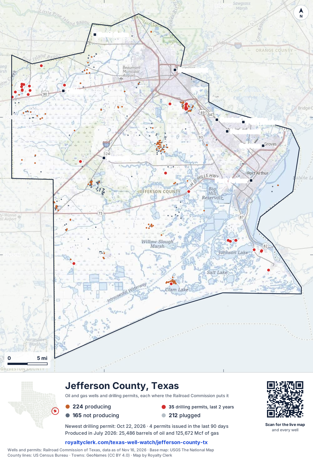
- Drilling locations35Permits issued in the last two years
- Producing wells224On a lease reporting production now
- Not producing165Shut in, inactive or no lease on record
- Plugged212The state's wellbore record says plugged
Sources: Railroad Commission of Texas well layers and permit files, US Census Bureau county outline, town points from GeoNames (CC BY 4.0), base map from USGS The National Map. A dot is a surface location; a horizontal well runs a mile or more from it.
601 wells with a location on the state's map and 35 drilling locations permitted in the last 24 months, each where the Railroad Commission puts it.
A permit is not a well.
Wells near each town in Jefferson County
- Beaumont312 wells
- Bevil Oaks925 wells
- Central Gardens377 wells
- China885 wells
- Fannett255 wells
- Groves346 wells
- Nederland375 wells
- Port Arthur67 wells
- Port Neches548 wells
Wells within 10 miles of each town, on either side of the county line.
Use this map on your site
You may show this map on any site, unchanged. Keep the credit line and its link to Royalty Clerk under the map. The picture updates by itself as the state records new wells and permits.
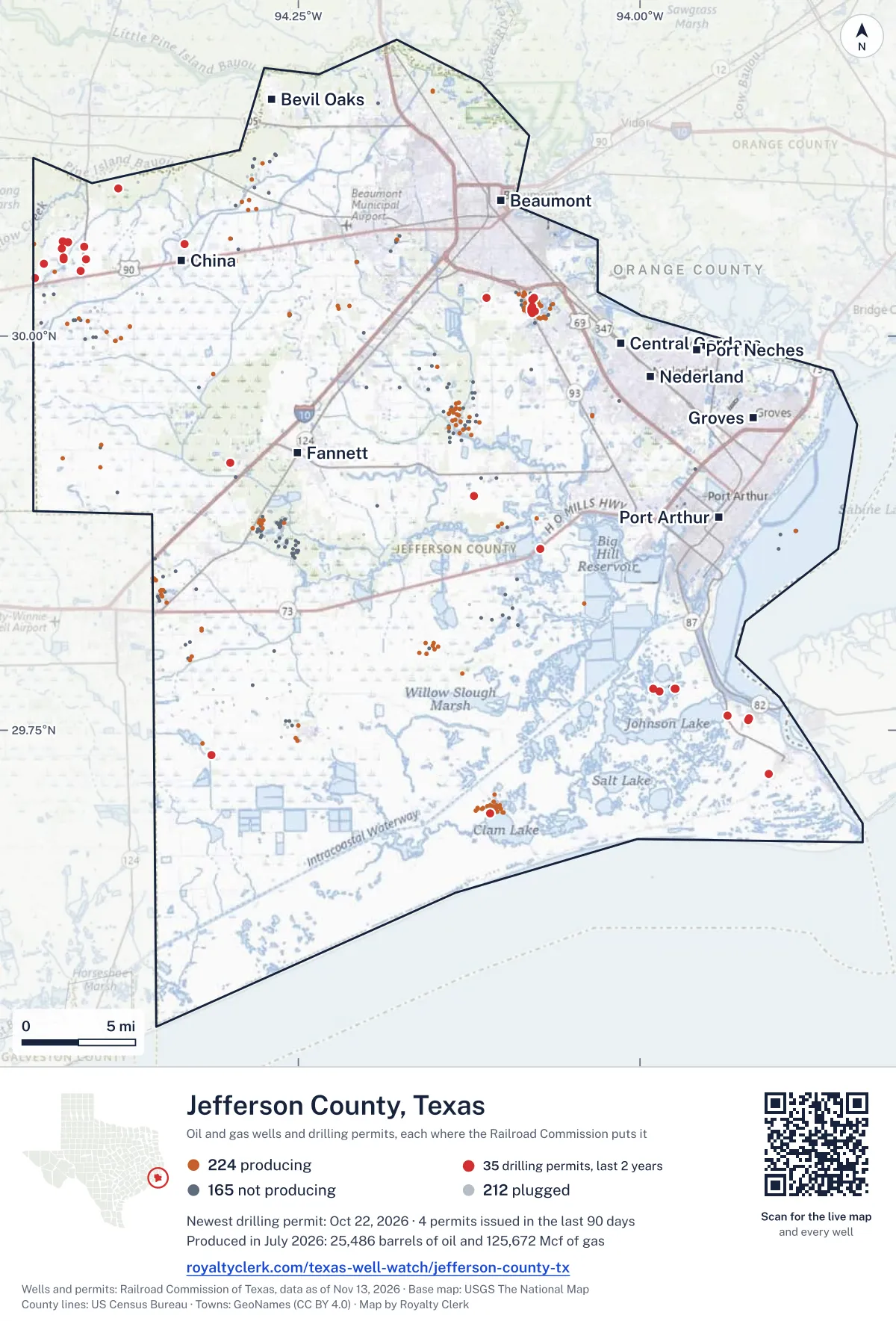
<a href="https://royaltyclerk.com/texas-well-watch/jefferson-county-tx"><img src="https://royaltyclerk.com/maps/county-wells/jefferson-county-tx.svg" alt="Map of Jefferson County, Texas, with 601 oil and gas wells and 35 recent drilling locations as dots." width="1000" height="1473" loading="lazy" style="max-width:100%;height:auto;border:0"></a>
<p style="margin:4px 0 0;font-size:14px">Map: <a href="https://royaltyclerk.com/texas-well-watch/jefferson-county-tx">Jefferson County, Texas oil and gas wells</a> by Royalty Clerk, from Railroad Commission of Texas records</p>
The last twelve months
Month by month in Jefferson County
| Month | Permits | Completions | First production |
|---|---|---|---|
| Oct 2026 | 4 | 0 | 0 |
| Jul 2026 | 5 | 3 | 2 |
| Jun 2026 | 1 | 0 | 0 |
| May 2026 | 1 | 1 | 0 |
| Apr 2026 | 1 | 1 | 0 |
| Mar 2026 | 2 | 0 | 0 |
| Feb 2026 | 10 | 1 | 0 |
Counted from November 15, 2025 to October 22, 2026, so the first and last months are partial. Source: Railroad Commission of Texas data sets.
Free, no sign-in
The newest drilling permits in Jefferson County
| Issued | Lease and well | Operator | Drilling began | Depth, ft | API number | Coordinates | Permit |
|---|---|---|---|---|---|---|---|
| 2026-10-22 | TIP-219 1new drill · verticalKinder Morgan Texas Pipeline LLCAPI 42-245-32943 · permit 091894329.75767, -93.91986450 ft | Kinder Morgan Texas Pipeline LLC | |||||
| 2026-10-22 | TIP-206 1new drill · verticalKinder Morgan Texas Pipeline LLCAPI 42-245-32942 · permit 091894229.86524, -94.07265480 ft | Kinder Morgan Texas Pipeline LLC | |||||
| 2026-10-22 | KMLP-03 1new drill · verticalKinder Morgan Texas Pipeline LLCAPI 42-245-32944 · permit 091894429.75655, -93.92112450 ft | Kinder Morgan Texas Pipeline LLC | |||||
| 2026-10-14 | TIP-202 1new drill · verticalKinder Morgan Texas Pipeline LLCAPI 42-245-32941 · permit 091893929.89856, -94.12157450 ft | Kinder Morgan Texas Pipeline LLC | |||||
| 2026-07-29 | MCFADDIN TRUST 91STrecompletion · verticalGepard Energy IncAPI 42-245-31934 · permit 091717929.69743, -94.109676,500 ft | Gepard Energy Inc | |||||
| 2026-07-27 | GOLDEN TRIANGLE STORAGE 11new drill · verticalGolden Triangle Storage, LLCAPI 42-245-32940 · permit 091742730.01839, -94.079048,500 ft | Golden Triangle Storage, LLC | |||||
| 2026-07-20 | MCFADDIN RANCH 15STrecompletion · verticalKingwood Exploration LLCAPI 42-245-32841 · permit 091728229.77612, -93.990277,773 ft | Kingwood Exploration LLC | |||||
| 2026-07-20 | MCFADDIN RANCH 13STrecompletion · verticalKingwood Exploration LLCAPI 42-245-32060 · permit 091726929.77489, -93.985727,735 ft | Kingwood Exploration LLC | |||||
| 2026-07-07 | GOLDEN TRIANGLE STORAGE 10new drill · verticalGolden Triangle Storage, LLCAPI 42-245-32939 · permit 091690530.01658, -94.079588,500 ft | Golden Triangle Storage, LLC | |||||
| 2026-06-10 | SUNFLOWER 2 AZM 2new drill · verticalExxonmobil Low C Sol on Stor LLCAPI 42-245-32938 · permit 091628630.04851, -94.42193drilling began 2026-07-17 · 4,000 ft | Exxonmobil Low C Sol on Stor LLC | |||||
| 2026-05-12 | GLADYS CITY 206new drill · verticalRheaco Oil Company, Ltd.API 42-245-32937 · permit 091552430.01594, -94.076651,500 ft | Rheaco Oil Company, Ltd. | |||||
| 2026-04-21 | GOLDEN TRIANGLE STORAGE 8new drill · verticalGolden Triangle Storage, LLCAPI 42-245-32936 · permit 091494230.02400, -94.07734drilling began 2026-08-06 · 8,000 ft | Golden Triangle Storage, LLC | |||||
| 2026-03-26 | GLADYS CITY 210new drill · verticalRheaco Oil Company, Ltd.API 42-245-32930 · permit 091249230.01594, -94.07929drilling began 2026-04-13 · 1,500 ft | Rheaco Oil Company, Ltd. | |||||
| 2026-03-05 | SPINDLETOP BAYOU 1new drill · verticalRusk Energy Operating LLCAPI 42-245-32935 · permit 091384329.73429, -94.31346drilling began 2026-05-18 · 11,500 ft | Rusk Energy Operating LLC | |||||
| 2026-02-13 | F.H. CARPENTER 001re-entry · verticalExxonmobil Low C Sol on Stor LLCAPI 42-245-00004 · permit 091342730.06035, -94.422417,753 ft | Exxonmobil Low C Sol on Stor LLC | |||||
| 2026-02-13 | WILLIS BH 001re-entry · verticalExxonmobil Low C Sol on Stor LLCAPI 42-245-00008 · permit 091342630.04109, -94.409536,500 ft | Exxonmobil Low C Sol on Stor LLC | |||||
| 2026-02-13 | FRANK CARPENTER ET AL 001re-entry · verticalExxonmobil Low C Sol on Stor LLCAPI 42-245-00005 · permit 091342530.05934, -94.418698,515 ft | Exxonmobil Low C Sol on Stor LLC | |||||
| 2026-02-13 | CARPENTER 001re-entry · verticalExxonmobil Low C Sol on Stor LLCAPI 42-245-30290 · permit 091342430.05579, -94.422987,816 ft | Exxonmobil Low C Sol on Stor LLC | |||||
| 2026-02-13 | WILSON ET AL 001re-entry · verticalExxonmobil Low C Sol on Stor LLCAPI 42-245-03214 · permit 091342330.05656, -94.406796,395 ft | Exxonmobil Low C Sol on Stor LLC | |||||
| 2026-02-13 | A M CARPENTER EST 001re-entry · verticalExxonmobil Low C Sol on Stor LLCAPI 42-245-03240 · permit 091342230.04964, -94.421575,928 ft | Exxonmobil Low C Sol on Stor LLC | |||||
| 2026-02-05 | SUNFLOWER INJ 3 3new drill · verticalExxonmobil Low C Sol on Stor LLCAPI 42-245-32931 · permit 091290230.04874, -94.405468,500 ft | Exxonmobil Low C Sol on Stor LLC | |||||
| 2026-02-05 | SUNFLOWER INJ 2 2new drill · verticalExxonmobil Low C Sol on Stor LLCAPI 42-245-32932 · permit 091290130.04854, -94.42200drilling began 2026-07-24 · 8,500 ft | Exxonmobil Low C Sol on Stor LLC | |||||
| 2026-02-03 | SUNFLOWER AZM/IZM 1new drill · verticalExxonmobil Low C Sol on Stor LLCAPI 42-245-32934 · permit 091290830.04581, -94.436318,500 ft | Exxonmobil Low C Sol on Stor LLC | |||||
| 2026-02-03 | SUNFLOWER INJ 6 6new drill · verticalExxonmobil Low C Sol on Stor LLCAPI 42-245-32929 · permit 091290730.03677, -94.442758,500 ft | Exxonmobil Low C Sol on Stor LLC | |||||
| 2025-11-13 | ICAP 1new drill · verticalMagnetar Operating LLCAPI 42-245-32927 · permit 091170130.09389, -94.38158drilling began 2025-12-09 · 12,300 ft | Magnetar Operating LLC | |||||
| 2025-07-02 | MCFADDIN RANCH 18new drill · verticalKingwood Exploration LLCAPI 42-245-32898 · permit 090903129.77649, -93.974188,000 ft | Kingwood Exploration LLC | |||||
| 2025-06-09 | MCFADDIN RANCH 17new drill · verticalKingwood Exploration LLCAPI 42-245-32897 · permit 090848829.77649, -93.97429drilling began 2025-06-29 · 8,000 ft | Kingwood Exploration LLC | |||||
| 2025-06-04 | RR RADLEY 1new drill · verticalRheaco Oil Company, Ltd.API 42-245-32926 · permit 090780330.02297, -94.079041,500 ft | Rheaco Oil Company, Ltd. | |||||
| 2025-06-02 | GOLDEN TRIANGLE STORAGE DISPOSAL 3Anew drill · verticalGolden Triangle Storage, LLCAPI 42-245-32925 · permit 090836930.02403, -94.11261drilling began 2025-08-23 · 8,000 ft | Golden Triangle Storage, LLC | |||||
| 2025-05-27 | GOLDEN PASS KM NGPL 1new drill · verticalGolden Pass Pipeline LLCAPI 42-245-32924 · permit 090813729.75917, -93.93611500 ft | Golden Pass Pipeline LLC | |||||
| 2025-05-15 | GLADYS CITY 205new drill · verticalRheaco Oil Company, Ltd.API 42-245-32922 · permit 090779430.01447, -94.078601,500 ft | Rheaco Oil Company, Ltd. | |||||
| 2025-05-07 | GLADYS CITY 209new drill · verticalRheaco Oil Company, Ltd.API 42-245-32923 · permit 090780130.01748, -94.07934drilling began 2026-02-02 · 1,100 ft | Rheaco Oil Company, Ltd. | |||||
| 2025-05-05 | G. W. BROWN UNIT 2recompletion · verticalOrx Resources, L.L.C.API 42-245-32746 · permit 090741229.91950, -94.3000611,750 ft | Orx Resources, L.L.C. | |||||
| 2025-04-29 | DEEP SKY 1new drill · verticalBallard Exploration Company,inc.API 42-245-32919 · permit 090540330.05816, -94.33349drilling began 2025-06-02 · 15,200 ft | Ballard Exploration Company,inc. | |||||
| 2025-04-25 | BPX 1new drill · verticalGeoterre Operating, L.L.C.API 42-245-32921 · permit 090746229.72245, -93.90592drilling began 2025-06-21 · 8,650 ft | Geoterre Operating, L.L.C. | |||||
| 2024-11-12 | CATHODIC PROTECTION 21new drill · verticalTexas Pipeline LLCAPI 42-245-32918 · permit 090384329.83087, -93.96522300 ft | Texas Pipeline LLC | |||||
| 2024-10-29 | BRINE DISPOSAL #1 3new drill · verticalEnergy Transfer Spindletop LLCAPI 42-245-32917 · permit 090361630.02490, -94.11000drilling began 2024-11-29 · 8,100 ft | Energy Transfer Spindletop LLC | |||||
| 2024-10-04 | MCFADDIN RANCH 15STrecompletion · verticalKingwood Exploration LLCAPI 42-245-32841 · permit 090309129.77612, -93.99027drilling began 2024-07-16 · 7,773 ft | Kingwood Exploration LLC | |||||
| 2024-09-20 | BROUSSARD JE JR-1 1re-entry · verticalExxonmobil Low C Sol on Stor LLCAPI 42-245-02193 · permit 090279329.99610, -94.288119,050 ft | Exxonmobil Low C Sol on Stor LLC | |||||
| 2024-07-30 | GOLDEN TRIANGLE STORAGE 3new drill · verticalGolden Triangle Storage, LLCAPI 42-245-32916 · permit 090163930.02219, -94.07598drilling began 2024-11-08 · 6,500 ft | Golden Triangle Storage, LLC | |||||
| 2024-07-30 | GOLDEN TRIANGLE STORAGE 4new drill · verticalGolden Triangle Storage, LLCAPI 42-245-32915 · permit 090163030.02475, -94.07527drilling began 2025-03-05 · 6,500 ft | Golden Triangle Storage, LLC | |||||
| 2024-07-11 | BEAD FARM COMPANY 4new drill · verticalExxonmobil Low C Sol on Stor LLCAPI 42-245-32914 · permit 090118030.02156, -94.29398drilling began 2024-08-31 · 10,000 ft | Exxonmobil Low C Sol on Stor LLC | |||||
| 2024-05-07 | MCFADDIN RANCH 13STrecompletion · verticalKingwood Exploration LLCAPI 42-245-32060 · permit 089945929.77489, -93.985727,735 ft | Kingwood Exploration LLC | |||||
| 2024-04-17 | BEAD FARM 3new drill · verticalExxonmobil Low C Sol on Stor LLCAPI 42-245-32912 · permit 089845030.01178, -94.29787drilling began 2024-08-05 · 10,000 ft | Exxonmobil Low C Sol on Stor LLC | |||||
| 2024-04-05 | LABELLE PROPERTIES LTD 1new drill · verticalExxonmobil Low C Sol on Stor LLCAPI 42-245-32913 · permit 089844829.99968, -94.28511drilling began 2024-06-23 · 10,000 ft | Exxonmobil Low C Sol on Stor LLC | |||||
| 2024-04-04 | BEAD FARM CO. 2new drill · verticalExxonmobil Low C Sol on Stor LLCAPI 42-245-32911 · permit 089844929.99102, -94.29804drilling began 2024-07-15 · 10,000 ft | Exxonmobil Low C Sol on Stor LLC | |||||
| 2024-02-23 | JUNKER SPENCER 1new drill · verticalFort Apache Energy, Inc.API 42-245-32910 · permit 089756429.86809, -94.25771drilling began 2024-02-29 · 9,200 ft | Fort Apache Energy, Inc. | |||||
| 2023-11-09 | BBW-FIVE AGGIE S 1new drill · verticalBayou Bend CCS LLCAPI 42-245-32909 · permit 089467729.64958, -94.29192drilling began 2024-02-24 · 9,000 ft | Bayou Bend CCS LLC |
A permit is permission to drill, not a well. Source: Railroad Commission of Texas drilling permit files.
Year by year
Drilling permits issued in Jefferson County, by year
| Year | Permits issued |
|---|---|
| 2026 so far | 24 |
| 2025 | 11 |
| 2024 | 12 |
| 2023 | 1 |
Counted from the permit files we hold, which start in 2023; that first year may be partial. Source: Railroad Commission of Texas drilling permit files.
The latest
The most recent records
| Date | What, who and where |
|---|---|
| 2026-10-22 | Permit issued: Kinder Morgan Texas Pipeline LLCTIP-206 · A-113 · permit 0918942 |
| 2026-10-22 | Permit issued: Kinder Morgan Texas Pipeline LLCTIP-219 · A-123 · permit 0918943 |
| 2026-10-22 | Permit issued: Kinder Morgan Texas Pipeline LLCKMLP-03 · A-123 · permit 0918944 |
| 2026-10-14 | Permit issued: Kinder Morgan Texas Pipeline LLCTIP-202 · A-23 · permit 0918939 |
| 2026-07-29 | Permit issued: Gepard Energy IncMCFADDIN TRUST · A-783 · permit 0917179 |
| 2026-07-27 | Permit issued: Golden Triangle Storage, LLCGOLDEN TRIANGLE STORAGE · A-55 · permit 0917427 |
| 2026-07-21 | CompletedA-198 |
| 2026-07-20 | Permit issued: Kingwood Exploration LLCMCFADDIN RANCH · A-302 · permit 0917282 |
| 2026-07-20 | Permit issued: Kingwood Exploration LLCMCFADDIN RANCH · A-803 · permit 0917269 |
| 2026-07-16 | CompletedA-55 |
| 2026-07-07 | Permit issued: Golden Triangle Storage, LLCGOLDEN TRIANGLE STORAGE · A-55 · permit 0916905 |
| 2026-07-01 | First production: Kingwood Exploration LLCMcFaddin Ranch |
| 2026-07-01 | Completed: Kingwood Exploration LLCMCFADDIN RANCH · A-302 · permit 0917282 |
| 2026-07-01 | First production: Ballard Exploration Company,inc.Deep SKY · A-16 · permit 0905403 |
| 2026-06-10 | Permit issued: Exxonmobil Low C Sol on Stor LLCSUNFLOWER 2 AZM · A-231 · permit 0916286 |
Coming up
First checks coming due in Jefferson County
- Deep SKY, Ballard Exploration Company,inc.by November 28, 2026
- McFaddin Ranch, Kingwood Exploration LLCby November 28, 2026
Follow it
Watch Jefferson County, or one abstract
What do you want to follow?
Where the land is. Your deed or lease names it.
For example A-1119, or Bush, or T&P 38. Your deed or the tax bill has it.
Other counties
Drilling activity in other counties
Related
Related
- ToolTexas well watchPermit, completion, first production and when the first check is due.
- ToolIs this buyout offer fair?The offer as months of your income, what the acres mean, and the questions to ask.
- ToolIs this lease offer good?Bonus and royalty against the county, and a scan of the lease's clauses.
- Texas dataTexas operator changesWho took over whose leases in the last 24 months.
- ToolLate payment interestDeadlines and the interest a late payment earns.
- Texas dataTexas oil and gas atlas254 counties, every lease, operator and field.
FAQ
Questions people ask
How many wells were permitted in Jefferson County in the last year?
The Railroad Commission issued 24 drilling permits in Jefferson County in the twelve months to October 22, 2026, and recorded 6 completions and 2 first-production reports. A permit is permission to drill, not a well.
How do I get an alert when a permit is issued near my land in Jefferson County?
Choose your abstract on this page, or the whole county, and sign in. You get one email a week, only when something new is recorded after you sign up. The alert says whether an event is on an interest in your Mineral File, on a place you follow, or only nearby.
When is my first royalty check due after a new well?
Natural Resources Code section 91.402(a) says on or before 120 days after the end of the month of first sale of production from the well. The state's first-production month is the closest public marker, so the date on this page is the earliest, not a certainty.
Got a new well on your land?
The first check is due within 120 days after the end of the month of first sale.
Sources
Primary sources, opened on 29 September 2026. Statute text is the current version on statutes.capitol.texas.gov.