
Jones County, Texas
Jones County drilling permits: what the state recorded
- 10drilling permits
- 3completions
- 1first-production report
- in the last twelve months
Wells by coordinates
Oil wells and drilling locations in Jones County
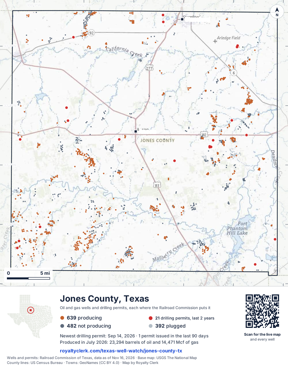
- Drilling locations21Permits issued in the last two years
- Producing wells641On a lease reporting production now
- Not producing482Shut in, inactive or no lease on record
- Plugged390The state's wellbore record says plugged
Sources: Railroad Commission of Texas well layers and permit files, US Census Bureau county outline, town points from GeoNames (CC BY 4.0), base map from USGS The National Map. A dot is a surface location; a horizontal well runs a mile or more from it.
1,513 wells with a location on the state's map and 21 drilling locations permitted in the last 24 months, each where the Railroad Commission puts it.
A permit is not a well.
Wells near each town in Jones County
Wells within 10 miles of each town, on either side of the county line.
Use this map on your site
You may show this map on any site, unchanged. Keep the credit line and its link to Royalty Clerk under the map. The picture updates by itself as the state records new wells and permits.
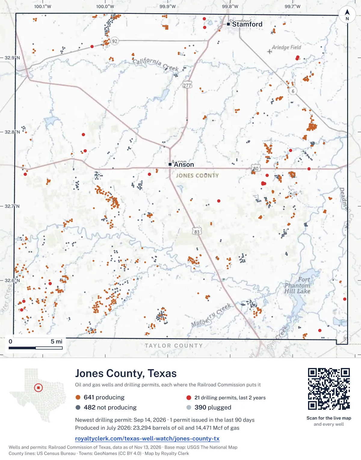
<a href="https://royaltyclerk.com/texas-well-watch/jones-county-tx"><img src="https://royaltyclerk.com/maps/county-wells/jones-county-tx.svg" alt="Map of Jones County, Texas, with 1,513 oil and gas wells and 21 recent drilling locations as dots." width="1000" height="1275" loading="lazy" style="max-width:100%;height:auto;border:0"></a>
<p style="margin:4px 0 0;font-size:14px">Map: <a href="https://royaltyclerk.com/texas-well-watch/jones-county-tx">Jones County, Texas oil and gas wells</a> by Royalty Clerk, from Railroad Commission of Texas records</p>
The last twelve months
Month by month in Jones County
| Month | Permits | Completions | First production |
|---|---|---|---|
| Sep 2026 | 1 | 0 | 0 |
| Aug 2026 | 3 | 0 | 0 |
| May 2026 | 2 | 1 | 0 |
| Apr 2026 | 3 | 0 | 0 |
| Jan 2026 | 0 | 1 | 1 |
| Dec 2025 | 1 | 0 | 0 |
| Nov 2025 | 0 | 1 | 0 |
Counted from November 15, 2025 to September 14, 2026, so the first and last months are partial. Source: Railroad Commission of Texas data sets.
Free, no sign-in
The newest drilling permits in Jones County
| Issued | Lease and well | Operator | Drilling began | Depth, ft | API number | Coordinates | Permit |
|---|---|---|---|---|---|---|---|
| 2026-09-14 | ABILENE 2.0 SE CR 306 & FM 1982 01new drill · verticalEnergy Transfer CompanyAPI 42-253-35754 · permit 091850332.53276, -99.65644420 ft | Energy Transfer Company | |||||
| 2026-08-12 | BAUCUM 3new drill · verticalStar Production, Inc.API 42-253-35753 · permit 091773932.72984, -99.74756drilling began 2026-08-17 · 3,500 ft | Star Production, Inc. | |||||
| 2026-08-07 | PITTARD 1new drill · verticalDelta Oil & Gas Ltd.API 42-253-35752 · permit 091762632.74317, -99.92898drilling began 2026-08-25 · 5,000 ft | Delta Oil & Gas Ltd. | |||||
| 2026-08-05 | HF SINCLAIR T015MPnew drill · verticalWbi Energy Midstream, LLCAPI 42-253-35751 · permit 091602532.75042, -99.67406drilling began 2026-08-24 · 350 ft | Wbi Energy Midstream, LLC | |||||
| 2026-05-27 | HALL 40 1new drill · verticalStar Production, Inc.API 42-253-35750 · permit 091581232.74155, -99.74107drilling began 2026-07-21 · 3,500 ft | Star Production, Inc. | |||||
| 2026-05-27 | BAUCUM 2new drill · verticalStar Production, Inc.API 42-253-35749 · permit 091579632.73122, -99.74757drilling began 2026-08-03 · 3,750 ft | Star Production, Inc. | |||||
| 2026-04-21 | TP #1.75 1new drill · verticalEnergy Transfer CompanyAPI 42-253-35748 · permit 091472532.70724, -99.81813400 ft | Energy Transfer Company | |||||
| 2026-04-20 | TP #9 1new drill · verticalEnergy Transfer CompanyAPI 42-253-35746 · permit 091454732.95266, -99.84142400 ft | Energy Transfer Company | |||||
| 2026-04-20 | TP #9.75 1new drill · verticalEnergy Transfer CompanyAPI 42-253-35747 · permit 091454332.94101, -99.84060400 ft | Energy Transfer Company | |||||
| 2025-12-11 | SWANN, W.D. 10new drill · verticalSojourner Drilling CorporationAPI 42-253-35745 · permit 091209932.57176, -100.13023drilling began 2026-03-25 · 5,000 ft | Sojourner Drilling Corporation | |||||
| 2025-09-30 | JAY (CANYON LIME) UNIT 212new drill · verticalSojourner Drilling CorporationAPI 42-253-35744 · permit 091076932.56030, -100.13362drilling began 2025-10-25 · 4,700 ft | Sojourner Drilling Corporation | |||||
| 2025-08-21 | OLIVER SWENSON 1recompletion · verticalIcs Energy LLCAPI 42-253-35726 · permit 090973132.89877, -99.69314drilling began 2024-04-11 · 5,500 ft | Ics Energy LLC | |||||
| 2025-08-11 | BIRDIE UNIT 1new drill · verticalSojourner Drilling CorporationAPI 42-253-35743 · permit 090977732.59567, -100.08838drilling began 2025-08-14 · 3,500 ft | Sojourner Drilling Corporation | |||||
| 2025-08-06 | TNT 2new drill · verticalHadaway Consult and Engineer,llcAPI 42-253-35742 · permit 090972432.74295, -100.128176,500 ft | Hadaway Consult and Engineer,llc | |||||
| 2025-04-21 | MANLY 1new drill · verticalGeosurveys, Inc.API 42-253-35741 · permit 090746032.57496, -99.61648drilling began 2025-05-16 · 2,000 ft | Geosurveys, Inc. | |||||
| 2025-04-14 | U-104 1new drill · verticalAtmos Energy Corp., Mid-Tex Div.API 42-253-35740 · permit 090735232.91513, -100.02127drilling began 2026-05-29 · 325 ft | Atmos Energy Corp., Mid-Tex Div. | |||||
| 2025-04-11 | BAUCUM 1new drill · verticalStar Production, Inc.API 42-253-35739 · permit 090731532.73067, -99.74479drilling began 2025-06-17 · 3,500 ft | Star Production, Inc. | |||||
| 2025-04-10 | STEELE 1new drill · verticalStar Production, Inc.API 42-253-35738 · permit 090731032.77532, -99.70299drilling began 2025-06-25 · 3,500 ft | Star Production, Inc. | |||||
| 2025-02-13 | WHITE 1new drill · verticalIcs Energy LLCAPI 42-253-35737 · permit 090591132.77467, -100.03194drilling began 2025-02-25 · 3,900 ft | Ics Energy LLC | |||||
| 2025-01-27 | BROWN 1new drill · verticalIcs Energy LLCAPI 42-253-35736 · permit 090544332.79646, -100.03498drilling began 2025-01-28 · 3,700 ft | Ics Energy LLC | |||||
| 2024-12-06 | OLIVER SWENSON 3new drill · verticalIcs Energy LLCAPI 42-253-35735 · permit 090445032.90112, -99.69176drilling began 2024-12-23 · 5,200 ft | Ics Energy LLC | |||||
| 2024-10-25 | OLIVER SWENSON 2new drill · verticalIcs Energy LLCAPI 42-253-35734 · permit 090355932.89856, -99.68918drilling began 2024-11-13 · 5,400 ft | Ics Energy LLC | |||||
| 2024-10-25 | HUDSPETH, W.R. 'D' 6new drill · verticalSojourner Drilling CorporationAPI 42-253-35733 · permit 090355332.61559, -100.14432drilling began 2025-03-15 · 5,500 ft | Sojourner Drilling Corporation | |||||
| 2024-10-25 | HUDSPETH, W.R. 'D' 5new drill · verticalSojourner Drilling CorporationAPI 42-253-35732 · permit 090355232.61766, -100.14252drilling began 2025-02-26 · 5,500 ft | Sojourner Drilling Corporation | |||||
| 2024-09-19 | LYTLE 1new drill · verticalProduction Operators of TX, LLCAPI 42-253-35731 · permit 090274132.75677, -99.97907drilling began 2024-09-30 · 3,500 ft | Production Operators of TX, LLC | |||||
| 2024-07-03 | HEP14 1new drill · verticalHolly Energy Partners-Op, L.P.API 42-253-35730 · permit 090082832.60173, -99.76206350 ft | Holly Energy Partners-Op, L.P. | |||||
| 2024-06-27 | DUSTY FARMER 1recompletion · verticalSojourner Drilling CorporationAPI 42-253-35687 · permit 090072932.56498, -100.094165,000 ft | Sojourner Drilling Corporation | |||||
| 2024-06-03 | IRVIN FEE 1new drill · verticalSojourner Drilling CorporationAPI 42-253-35729 · permit 090009432.61186, -100.07135drilling began 2024-06-07 · 3,000 ft | Sojourner Drilling Corporation | |||||
| 2024-05-08 | LEAVITT 2new drill · verticalIcs Energy LLCAPI 42-253-35728 · permit 089959032.85660, -99.75054drilling began 2024-07-12 · 2,300 ft | Ics Energy LLC | |||||
| 2024-04-15 | ATE565 1new drill · verticalAtmos Pipeline - TexasAPI 42-253-35727 · permit 089878932.94264, -99.82693450 ft | Atmos Pipeline - Texas | |||||
| 2024-04-05 | OLIVER SWENSON 1new drill · verticalIcs Energy LLCAPI 42-253-35726 · permit 089859732.89877, -99.69314drilling began 2024-04-11 · 5,500 ft | Ics Energy LLC | |||||
| 2024-04-02 | BAUCUM 1Anew drill · verticalS.b. Street Operating, Inc.API 42-253-35725 · permit 0898456drilling began 2024-07-16 · 3,999 ft | S.b. Street Operating, Inc. | |||||
| 2024-03-18 | LEAVITT 1new drill · verticalIcs Energy LLCAPI 42-253-35724 · permit 089821632.85528, -99.74996drilling began 2024-03-20 · 2,500 ft | Ics Energy LLC | |||||
| 2024-03-18 | HP 1new drill · verticalHadaway Consult and Engineer,llcAPI 42-253-35723 · permit 089792232.74945, -100.13199drilling began 2025-03-10 · 6,500 ft | Hadaway Consult and Engineer,llc | |||||
| 2024-03-12 | IRVIN FEE 1re-entry · verticalSojourner Drilling CorporationAPI 42-253-00049 · permit 089800632.61178, -100.071323,000 ft | Sojourner Drilling Corporation | |||||
| 2024-03-08 | BAGLEY 3new drill · verticalJQL Energy, LLCAPI 42-253-35722 · permit 089791932.84338, -99.72605drilling began 2024-04-30 · 2,999 ft | JQL Energy, LLC | |||||
| 2024-02-13 | TNT 1new drill · verticalHadaway Consult and Engineer,llcAPI 42-253-35721 · permit 089725032.74728, -100.12508drilling began 2024-03-09 · 6,500 ft | Hadaway Consult and Engineer,llc | |||||
| 2024-01-25 | ECT208 1new drill · verticalSunoco Pipeline L.P.API 42-253-35720 · permit 089671132.57348, -99.90632400 ft | Sunoco Pipeline L.P. | |||||
| 2024-01-24 | BRAUN 1new drill · verticalM. E. Operating & Services, Inc.API 42-253-35719 · permit 089666232.70005, -99.81720drilling began 2024-06-23 · 3,500 ft | M. E. Operating & Services, Inc. | |||||
| 2024-01-19 | OMAN ACSELL 1new drill · verticalIcs Energy LLCAPI 42-253-35718 · permit 089662432.89870, -99.68104drilling began 2024-01-31 · 5,500 ft | Ics Energy LLC | |||||
| 2023-12-04 | MCCASLIN 1new drill · verticalStar Production, Inc.API 42-253-35717 · permit 089566332.85506, -99.78522drilling began 2023-12-12 · 5,700 ft | Star Production, Inc. | |||||
| 2023-12-04 | RISLEY 'B' 7new drill · verticalNBX Energy, LLCAPI 42-253-35632 · permit 089550932.95759, -99.98978drilling began 2023-12-11 · 6,000 ft | NBX Energy, LLC | |||||
| 2023-10-03 | MUELLER 1new drill · verticalDelta Oil & Gas Ltd.API 42-253-35716 · permit 089427632.92994, -99.98734drilling began 2024-03-02 · 4,000 ft | Delta Oil & Gas Ltd. | |||||
| 2014-09-12 | DAVIS 4new drill · verticalIcs Energy LLCAPI 42-253-35414 · permit 079448432.87048, -99.67772drilling began 2015-01-27 · 2,900 ft | Ics Energy LLC |
A permit is permission to drill, not a well. Source: Railroad Commission of Texas drilling permit files.
Year by year
Drilling permits issued in Jones County, by year
| Year | Permits issued |
|---|---|
| 2026 so far | 9 |
| 2025 | 11 |
| 2024 | 20 |
| 2023 | 3 |
| 2014 | 1 |
Counted from the permit files we hold, which start in 2014; that first year may be partial. Source: Railroad Commission of Texas drilling permit files.
The latest
The most recent records
| Date | What, who and where |
|---|---|
| 2026-09-14 | Permit issued: Energy Transfer CompanyABILENE 2.0 SE CR 306 & FM 1982 · A-1035 · permit 0918503 |
| 2026-08-12 | Permit issued: Star Production, Inc.BAUCUM · A-1517 · permit 0917739 |
| 2026-08-07 | Permit issued: Delta Oil & Gas Ltd.PITTARD · A-353 · permit 0917626 |
| 2026-08-05 | Permit issued: Wbi Energy Midstream, LLCHF SINCLAIR · A-508 · permit 0916025 |
| 2026-05-27 | Permit issued: Star Production, Inc.HALL 40 · A-1900 · permit 0915812 |
| 2026-05-27 | Permit issued: Star Production, Inc.BAUCUM · A-1517 · permit 0915796 |
| 2026-05-17 | Completed: Sojourner Drilling CorporationSWANN, W.D. · A-268 · permit 0912099 |
| 2026-04-21 | Permit issued: Energy Transfer CompanyTP #1.75 · A-360 · permit 0914725 |
| 2026-04-20 | Permit issued: Energy Transfer CompanyTP #9.75 · A-33 · permit 0914543 |
| 2026-04-20 | Permit issued: Energy Transfer CompanyTP #9 · A-1914 · permit 0914547 |
| 2026-01-28 | Completed: Star Production, Inc.BAUCUM · A-1517 · permit 0907315 |
| 2026-01-01 | First production: Star Production, Inc.Baucum · A-1517 · permit 0907315 |
| 2025-12-11 | Permit issued: Sojourner Drilling CorporationSWANN, W.D. · A-268 · permit 0912099 |
| 2025-11-21 | Completed: Sojourner Drilling CorporationJAY (CANYON LIME) UNIT · A-268 · permit 0910769 |
Follow it
Watch Jones County, or one abstract
What do you want to follow?
Where the land is. Your deed or lease names it.
For example A-1119, or Bush, or T&P 38. Your deed or the tax bill has it.
Other counties
Drilling activity in other counties
Related
Related
- ToolTexas well watchPermit, completion, first production and when the first check is due.
- ToolIs this buyout offer fair?The offer as months of your income, what the acres mean, and the questions to ask.
- ToolIs this lease offer good?Bonus and royalty against the county, and a scan of the lease's clauses.
- Texas dataTexas operator changesWho took over whose leases in the last 24 months.
- ToolLate payment interestDeadlines and the interest a late payment earns.
- Texas dataTexas oil and gas atlas254 counties, every lease, operator and field.
FAQ
Questions people ask
How many wells were permitted in Jones County in the last year?
The Railroad Commission issued 10 drilling permits in Jones County in the twelve months to September 14, 2026, and recorded 3 completions and 1 first-production report. A permit is permission to drill, not a well.
How do I get an alert when a permit is issued near my land in Jones County?
Choose your abstract on this page, or the whole county, and sign in. You get one email a week, only when something new is recorded after you sign up. The alert says whether an event is on an interest in your Mineral File, on a place you follow, or only nearby.
When is my first royalty check due after a new well?
Natural Resources Code section 91.402(a) says on or before 120 days after the end of the month of first sale of production from the well. The state's first-production month is the closest public marker, so the date on this page is the earliest, not a certainty.
Got a new well on your land?
The first check is due within 120 days after the end of the month of first sale.
Sources
Primary sources, opened on 29 September 2026. Statute text is the current version on statutes.capitol.texas.gov.