
Matagorda County, Texas
Matagorda County drilling permits: what the state recorded
- 2drilling permits
- 6completions
- 3first-production reports
- in the last twelve months
Wells by coordinates
Oil wells and drilling locations in Matagorda County
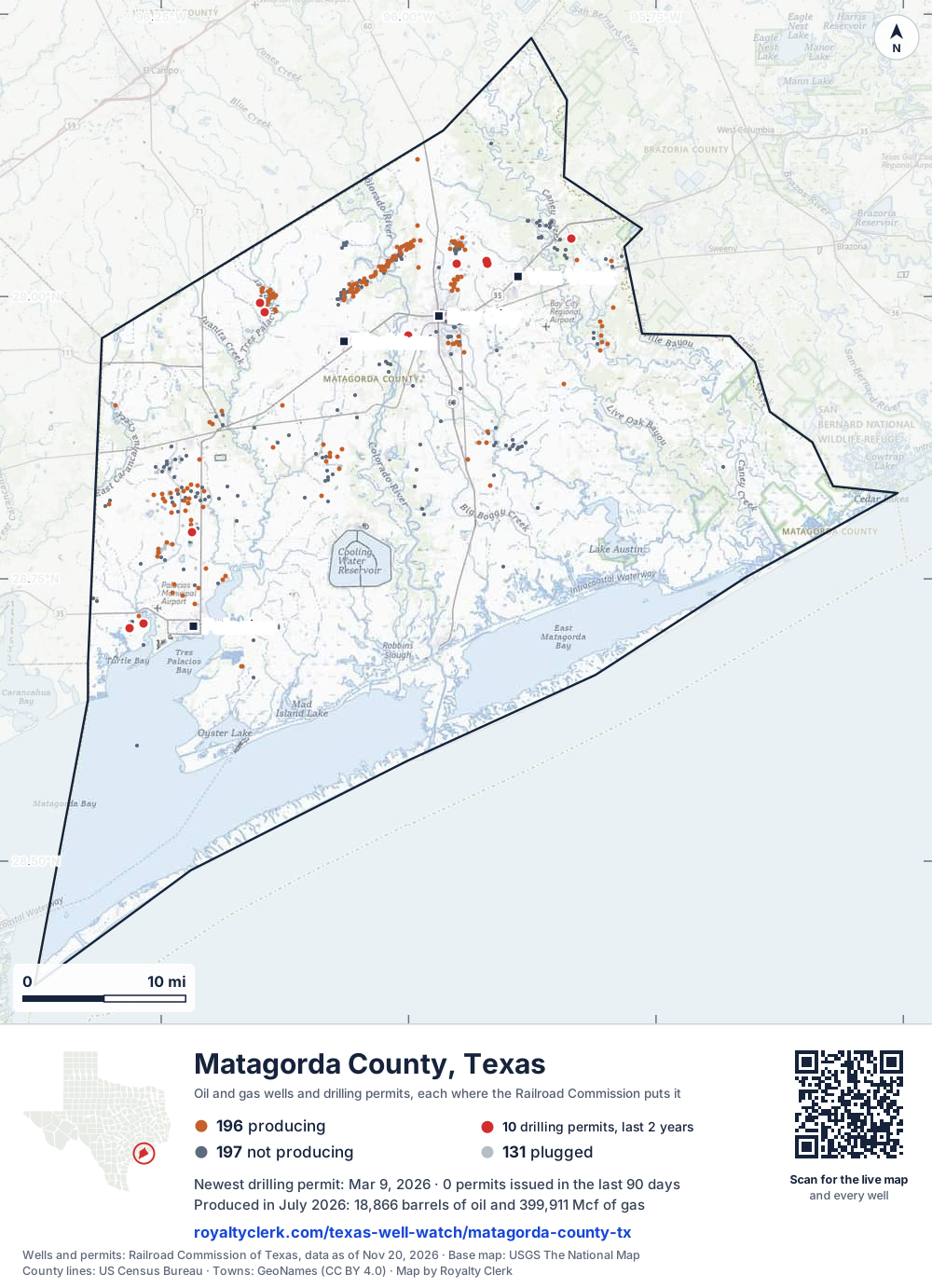
- Drilling locations10Permits issued in the last two years
- Producing wells196On a lease reporting production now
- Not producing199Shut in, inactive or no lease on record
- Plugged129The state's wellbore record says plugged
Sources: Railroad Commission of Texas well layers and permit files, US Census Bureau county outline, town points from GeoNames (CC BY 4.0), base map from USGS The National Map. A dot is a surface location; a horizontal well runs a mile or more from it.
524 wells with a location on the state's map and 10 drilling locations permitted in the last 24 months, each where the Railroad Commission puts it.
A permit is not a well.
Wells near each town in Matagorda County
Wells within 10 miles of each town, on either side of the county line.
Use this map on your site
You may show this map on any site, unchanged. Keep the credit line and its link to Royalty Clerk under the map. The picture updates by itself as the state records new wells and permits.
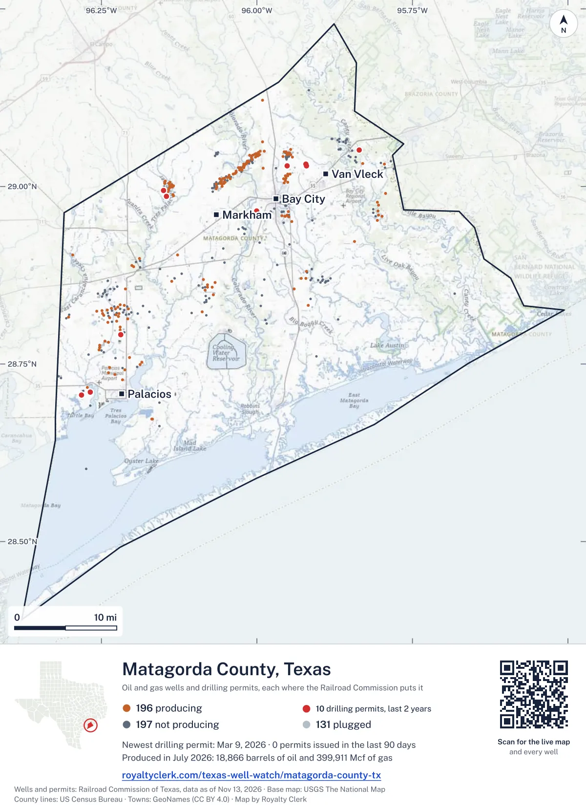
<a href="https://royaltyclerk.com/texas-well-watch/matagorda-county-tx"><img src="https://royaltyclerk.com/maps/county-wells/matagorda-county-tx.svg" alt="Map of Matagorda County, Texas, with 524 oil and gas wells and 10 recent drilling locations as dots." width="1000" height="1382" loading="lazy" style="max-width:100%;height:auto;border:0"></a>
<p style="margin:4px 0 0;font-size:14px">Map: <a href="https://royaltyclerk.com/texas-well-watch/matagorda-county-tx">Matagorda County, Texas oil and gas wells</a> by Royalty Clerk, from Railroad Commission of Texas records</p>
The last twelve months
Month by month in Matagorda County
| Month | Permits | Completions | First production |
|---|---|---|---|
| Jul 2026 | 0 | 0 | 1 |
| Jun 2026 | 0 | 2 | 0 |
| Apr 2026 | 0 | 2 | 1 |
| Mar 2026 | 1 | 0 | 1 |
| Feb 2026 | 0 | 1 | 0 |
| Jan 2026 | 0 | 1 | 0 |
| Nov 2025 | 1 | 0 | 0 |
Counted from November 15, 2025 to July 1, 2026, so the first and last months are partial. Source: Railroad Commission of Texas data sets.
Free, no sign-in
The newest drilling permits in Matagorda County
| Issued | Lease and well | Operator | Drilling began | Depth, ft | API number | Coordinates | Permit |
|---|---|---|---|---|---|---|---|
| 2026-03-09 | SMITH, LEWIS EDWIN ET AL 4new drill · verticalUnderground Services Markham,llcAPI 42-321-32464 · permit 091391028.98646, -96.14548drilling began 2026-04-12 · 7,400 ft | Underground Services Markham,llc | |||||
| 2025-11-19 | BOONIE JENSEN 1recompletion · verticalKebo Oil & Gas, Inc.API 42-321-32417 · permit 091181228.71015, -96.268288,890 ft | Kebo Oil & Gas, Inc. | |||||
| 2025-10-30 | H. SMITH 1new drill · verticalUnderground Services Markham,llcAPI 42-321-32463 · permit 091147128.99449, -96.15014drilling began 2026-01-31 · 7,400 ft | Underground Services Markham,llc | |||||
| 2025-09-23 | ANDERSON 1recompletion · verticalMagnum Producing, LPAPI 42-321-32361 · permit 091061328.96532, -96.0002710,700 ft | Magnum Producing, LP | |||||
| 2025-07-14 | BUNK 1recompletion · verticalPonderosa Oil & Gas, LLCAPI 42-321-32444 · permit 090908729.02862, -95.95118drilling began 2025-05-27 · 12,000 ft | Ponderosa Oil & Gas, LLC | |||||
| 2025-06-26 | JENSEN 1new drill · verticalBruington Operating II, LLCAPI 42-321-32462 · permit 090877828.70636, -96.28173drilling began 2025-11-08 · 8,900 ft | Bruington Operating II, LLC | |||||
| 2025-04-15 | NORRIS 3re-entry · verticalPonderosa Oil & Gas, LLCAPI 42-321-31914 · permit 090668929.02920, -95.92058drilling began 2025-11-06 · 11,300 ft | Ponderosa Oil & Gas, LLC | |||||
| 2025-04-03 | NORRIS 2recompletion · verticalPonderosa Oil & Gas, LLCAPI 42-321-32437 · permit 089789629.03189, -95.9216011,500 ft | Ponderosa Oil & Gas, LLC | |||||
| 2025-02-05 | ELDER 1new drill · verticalKebo Oil & Gas, Inc.API 42-321-32461 · permit 090505628.79099, -96.21862drilling began 2026-07-31 · 9,350 ft | Kebo Oil & Gas, Inc. | |||||
| 2024-12-12 | TAYLOR RANCH 1recompletion · verticalPonderosa Oil & Gas, LLCAPI 42-321-32375 · permit 090447429.05140, -95.83557drilling began 2024-11-13 · 10,231 ft | Ponderosa Oil & Gas, LLC | |||||
| 2024-10-21 | GALILEO 1new drill · verticalHilcorp Energy CompanyAPI 42-321-32460 · permit 090329928.71437, -95.9101916,000 ft | Hilcorp Energy Company | |||||
| 2024-09-17 | NORRIS 1recompletion · verticalPonderosa Oil & Gas, LLCAPI 42-321-32427 · permit 089790829.03112, -95.9224411,500 ft | Ponderosa Oil & Gas, LLC | |||||
| 2024-04-17 | BUNK 1recompletion · verticalPonderosa Oil & Gas, LLCAPI 42-321-32444 · permit 089821829.02862, -95.9511812,000 ft | Ponderosa Oil & Gas, LLC | |||||
| 2023-09-12 | VIPER CHILEK 1new drill · verticalViper S.w.d., LLCAPI 42-321-32459 · permit 089338228.71126, -96.10764drilling began 2023-10-17 · 6,000 ft | Viper S.w.d., LLC |
A permit is permission to drill, not a well. Source: Railroad Commission of Texas drilling permit files.
Year by year
Drilling permits issued in Matagorda County, by year
| Year | Permits issued |
|---|---|
| 2026 so far | 1 |
| 2025 | 8 |
| 2024 | 4 |
| 2023 | 1 |
Counted from the permit files we hold, which start in 2023; that first year may be partial. Source: Railroad Commission of Texas drilling permit files.
The latest
The most recent records
| Date | What, who and where |
|---|---|
| 2026-07-01 | First production: Kebo Oil & Gas, Inc.Blessing F-3 Unit O/A |
| 2026-06-25 | CompletedA-68 |
| 2026-06-21 | Completed: Underground Services Markham,llcSMITH, LEWIS EDWIN ET AL · A-68 · permit 0913910 |
| 2026-04-07 | Completed: Bruington Operating II, LLCJENSEN · A-140 · permit 0908778 |
| 2026-04-05 | Completed: Underground Services Markham,llcH. SMITH · A-68 · permit 0911471 |
| 2026-04-01 | First production: Bruington Operating II, LLCNaomi Jensen Unit · A-140 · permit 0908778 |
| 2026-03-09 | Permit issued: Underground Services Markham,llcSMITH, LEWIS EDWIN ET AL · A-68 · permit 0913910 |
| 2026-03-01 | First production: Atlas Operating LLCWatson, F M, Trust Et Al "B" |
| 2026-02-05 | Completed: Magnum Producing, LPANDERSON · A-45 · permit 0910613 |
| 2026-01-10 | Completed: Bruington Operating II, LLCJENSEN · A-140 · permit 0908778 |
| 2025-11-19 | Permit issued: Kebo Oil & Gas, Inc.BOONIE JENSEN · A-133 · permit 0911812 |
Coming up
First checks coming due in Matagorda County
- Blessing F-3 Unit O/A, Kebo Oil & Gas, Inc.by November 28, 2026
Follow it
Watch Matagorda County, or one abstract
What do you want to follow?
Where the land is. Your deed or lease names it.
For example A-1119, or Bush, or T&P 38. Your deed or the tax bill has it.
Other counties
Drilling activity in other counties
Related
Related
- ToolTexas well watchPermit, completion, first production and when the first check is due.
- ToolIs this buyout offer fair?The offer as months of your income, what the acres mean, and the questions to ask.
- ToolIs this lease offer good?Bonus and royalty against the county, and a scan of the lease's clauses.
- Texas dataTexas operator changesWho took over whose leases in the last 24 months.
- ToolLate payment interestDeadlines and the interest a late payment earns.
- Texas dataTexas oil and gas atlas254 counties, every lease, operator and field.
FAQ
Questions people ask
How many wells were permitted in Matagorda County in the last year?
The Railroad Commission issued 2 drilling permits in Matagorda County in the twelve months to July 1, 2026, and recorded 6 completions and 3 first-production reports. A permit is permission to drill, not a well.
How do I get an alert when a permit is issued near my land in Matagorda County?
Choose your abstract on this page, or the whole county, and sign in. You get one email a week, only when something new is recorded after you sign up. The alert says whether an event is on an interest in your Mineral File, on a place you follow, or only nearby.
When is my first royalty check due after a new well?
Natural Resources Code section 91.402(a) says on or before 120 days after the end of the month of first sale of production from the well. The state's first-production month is the closest public marker, so the date on this page is the earliest, not a certainty.
Got a new well on your land?
The first check is due within 120 days after the end of the month of first sale.
Sources
Primary sources, opened on 29 September 2026. Statute text is the current version on statutes.capitol.texas.gov.