
Nueces County, Texas
Nueces County drilling permits: what the state recorded
- 3drilling permits
- 2completions
- 1first-production report
- in the last twelve months
Wells by coordinates
Oil wells and drilling locations in Nueces County
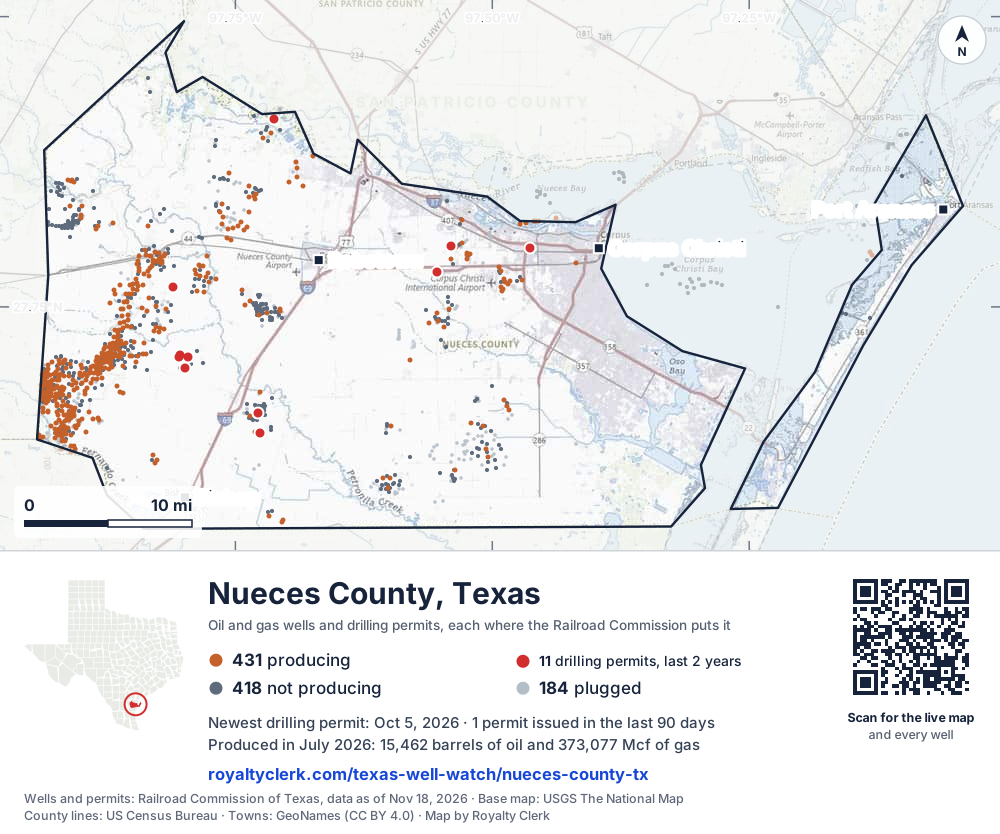
- Drilling locations11Permits issued in the last two years
- Producing wells431On a lease reporting production now
- Not producing418Shut in, inactive or no lease on record
- Plugged184The state's wellbore record says plugged
Sources: Railroad Commission of Texas well layers and permit files, US Census Bureau county outline, town points from GeoNames (CC BY 4.0), base map from USGS The National Map. A dot is a surface location; a horizontal well runs a mile or more from it.
1,033 wells with a location on the state's map and 11 drilling locations permitted in the last 24 months, each where the Railroad Commission puts it.
A permit is not a well.
Wells near each town in Nueces County
Wells within 10 miles of each town, on either side of the county line.
Use this map on your site
You may show this map on any site, unchanged. Keep the credit line and its link to Royalty Clerk under the map. The picture updates by itself as the state records new wells and permits.
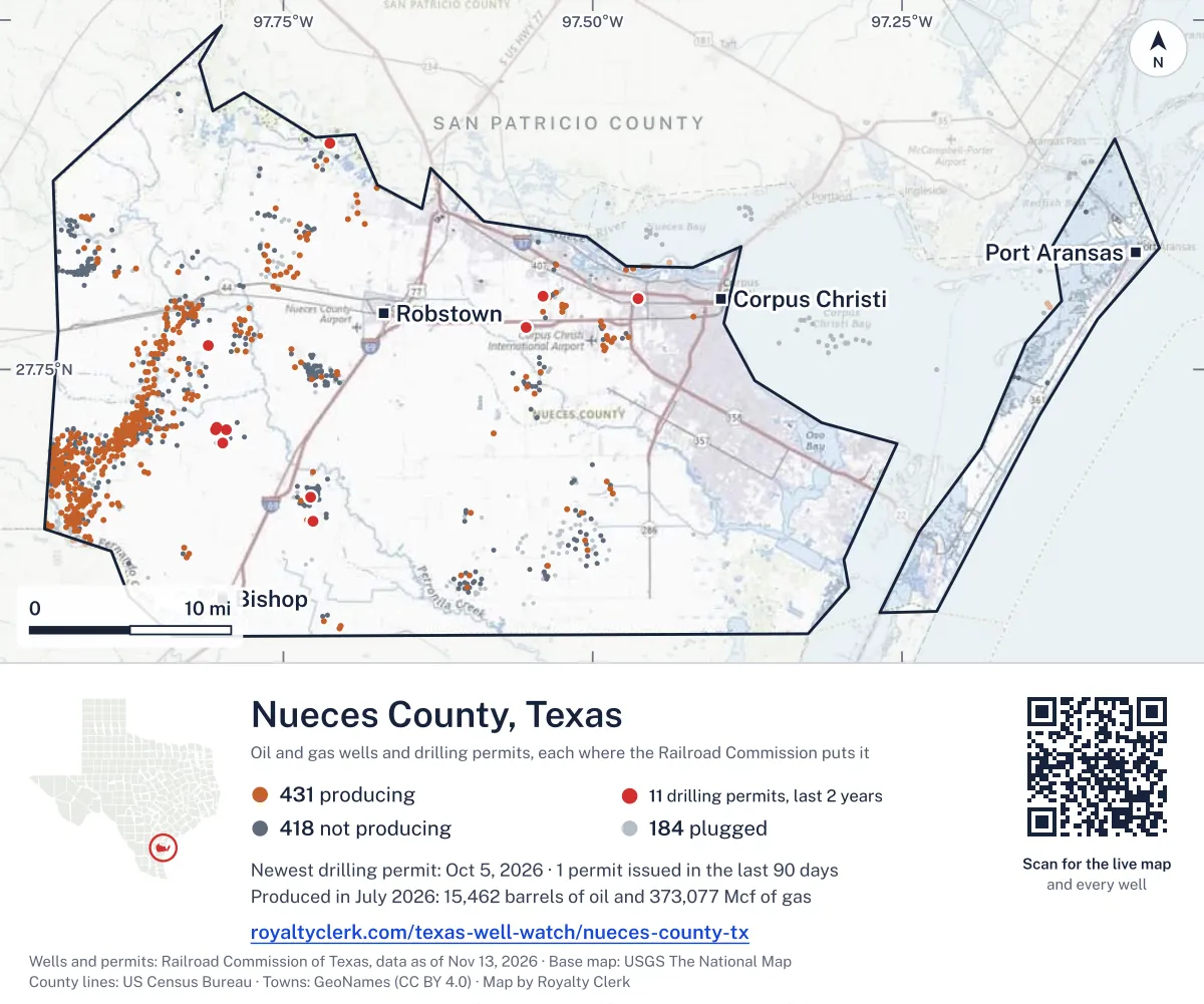
<a href="https://royaltyclerk.com/texas-well-watch/nueces-county-tx"><img src="https://royaltyclerk.com/maps/county-wells/nueces-county-tx.svg" alt="Map of Nueces County, Texas, with 1,033 oil and gas wells and 11 recent drilling locations as dots." width="1000" height="834" loading="lazy" style="max-width:100%;height:auto;border:0"></a>
<p style="margin:4px 0 0;font-size:14px">Map: <a href="https://royaltyclerk.com/texas-well-watch/nueces-county-tx">Nueces County, Texas oil and gas wells</a> by Royalty Clerk, from Railroad Commission of Texas records</p>
The last twelve months
Month by month in Nueces County
| Month | Permits | Completions | First production |
|---|---|---|---|
| Oct 2026 | 1 | 0 | 0 |
| Jul 2026 | 0 | 0 | 1 |
| Jun 2026 | 1 | 1 | 0 |
| Feb 2026 | 0 | 1 | 0 |
| Jan 2026 | 1 | 0 | 0 |
Counted from November 19, 2025 to October 5, 2026, so the first and last months are partial. Source: Railroad Commission of Texas data sets.
Free, no sign-in
The newest drilling permits in Nueces County
| Issued | Lease and well | Operator | Drilling began | Depth, ft | API number | Coordinates | Permit |
|---|---|---|---|---|---|---|---|
| 2026-10-05 | CP# 26-180 CATHODIC PROTECTION 45new drill · verticalEnterprise Products OperatingllcAPI 42-355-34233 · permit 091881027.80110, -97.46299400 ft | Enterprise Products Operatingllc | |||||
| 2026-06-18 | HARLAN 1new drill · verticalPaloma Operating, LLCAPI 42-355-34232 · permit 091649027.69771, -97.79871drilling began 2026-07-24 · 7,800 ft | Paloma Operating, LLC | |||||
| 2026-01-14 | RIVERS 1new drill · verticalPaloma Operating, LLCAPI 42-355-34231 · permit 091271127.70668, -97.79590drilling began 2026-03-07 · 7,700 ft | Paloma Operating, LLC | |||||
| 2025-11-18 | DRISCOLL FOUNDATION 1Dre-entry · verticalPaloma Operating, LLCAPI 42-355-04918 · permit 091180027.70666, -97.804487,410 ft | Paloma Operating, LLC | |||||
| 2025-10-16 | KITTOE 1new drill · verticalPangea's Edge Operating Co LLCAPI 42-355-34230 · permit 091096027.76711, -97.81093drilling began 2026-01-23 · 11,000 ft | Pangea's Edge Operating Co LLC | |||||
| 2025-06-11 | FLINN GAS UNIT 1recompletion · verticalDewbre Petroleum CorporationAPI 42-355-05946 · permit 090849627.65838, -97.727948,989 ft | Dewbre Petroleum Corporation | |||||
| 2025-05-19 | MILLER UNIT 4Urecompletion · verticalHarris Energy Services, LLCAPI 42-355-32949 · permit 090774827.91209, -97.71242drilling began 1994-03-10 · 6,925 ft | Harris Energy Services, LLC | |||||
| 2025-04-22 | FRANK E. BLISS 22recompletion · verticalAnderson Oil Ltd.API 42-355-01633 · permit 090749527.80267, -97.54031drilling began 2022-08-02 · 9,232 ft | Anderson Oil Ltd. | |||||
| 2025-03-17 | H.A. JOHNSON 1Rre-entry · verticalPaloma Operating, LLCAPI 42-355-06651 · permit 090670927.64114, -97.725656,750 ft | Paloma Operating, LLC | |||||
| 2025-03-13 | WEIL FAMILY 1new drill · verticalRoyal Production Company, Inc.API 42-355-34229 · permit 090665727.78003, -97.55390drilling began 2025-07-19 · 7,300 ft | Royal Production Company, Inc. | |||||
| 2025-03-03 | DRISCOLL FOUNDATION 1new drill · verticalPaloma Operating, LLCAPI 42-355-34228 · permit 090629827.70847, -97.80431drilling began 2025-03-21 · 7,600 ft | Paloma Operating, LLC | |||||
| 2024-10-03 | SIMNACHER UNIT 1new drill · verticalSuemaur Operating LLCAPI 42-355-34227 · permit 090248827.83255, -97.72430drilling began 2024-10-26 · 10,600 ft | Suemaur Operating LLC | |||||
| 2024-08-14 | DUGGER 3recompletion · verticalKRC Operating, LLCAPI 42-355-33705 · permit 090191827.65246, -97.728968,881 ft | KRC Operating, LLC | |||||
| 2024-06-26 | MCCLUER 1new drill · verticalS & D Vacuum Service, LLCAPI 42-355-34226 · permit 090077827.83462, -97.78413drilling began 2024-12-01 · 4,880 ft | S & D Vacuum Service, LLC | |||||
| 2024-04-18 | PERKINS-LAGASSE 2recompletion · verticalGreat Western Drilling CompanyAPI 42-355-33947 · permit 089880727.80330, -97.531917,500 ft | Great Western Drilling Company | |||||
| 2024-03-12 | VIPER DUGGER 2new drill · verticalViper S.w.d., LLCAPI 42-355-34225 · permit 089807827.64254, -97.731137,100 ft | Viper S.w.d., LLC | |||||
| 2024-02-07 | HRNCIR, ET AL UNIT 3new drill · verticalSuemaur Expl. & Prod., LLCAPI 42-355-34224 · permit 089707127.81392, -97.74401drilling began 2024-07-04 · 10,500 ft | Suemaur Expl. & Prod., LLC | |||||
| 2024-01-25 | HLMW 1new drill · verticalPaloma Operating, LLCAPI 42-355-34223 · permit 089676327.61822, -97.83119drilling began 2024-03-22 · 7,800 ft | Paloma Operating, LLC | |||||
| 2024-01-19 | BATES 1new drill · verticalTag Operating Company, Inc.API 42-355-34221 · permit 089620627.85426, -97.68468drilling began 2024-04-03 · 8,800 ft | Tag Operating Company, Inc. | |||||
| 2024-01-16 | VIPER DUGGER 1new drill · verticalViper S.w.d., LLCAPI 42-355-34222 · permit 089651827.64333, -97.72844drilling began 2024-03-06 · 7,100 ft | Viper S.w.d., LLC | |||||
| 2023-11-07 | MEJIA UNIT 1recompletion · verticalForza Operating, LLCAPI 42-355-34116 · permit 089494527.91474, -97.732087,500 ft | Forza Operating, LLC | |||||
| 2023-11-03 | LYONDELL5 C 01new drill · verticalEquistar Chemicals, LPAPI 42-355-34220 · permit 089390627.81431, -97.59734250 ft | Equistar Chemicals, LP | |||||
| 2023-11-03 | ERIGAN-QUIROZ 4recompletion · verticalAnderson Oil Ltd.API 42-355-32869 · permit 089361327.82523, -97.529167,300 ft | Anderson Oil Ltd. | |||||
| 2023-07-21 | WILSON 1new drill · verticalHarris Energy Services, LLCAPI 42-355-34219 · permit 089220127.90834, -97.71901drilling began 2023-11-26 · 7,800 ft | Harris Energy Services, LLC | |||||
| 2009-11-19 | DUGGER, L.M. 22recompletion · verticalKRC Operating, LLCAPI 42-355-33936 · permit 068757727.75160, -97.73215drilling began 2009-10-09 · 8,309 ft | KRC Operating, LLC |
A permit is permission to drill, not a well. Source: Railroad Commission of Texas drilling permit files.
Year by year
Drilling permits issued in Nueces County, by year
| Year | Permits issued |
|---|---|
| 2026 so far | 3 |
| 2025 | 8 |
| 2024 | 9 |
| 2023 | 4 |
| 2009 | 1 |
Counted from the permit files we hold, which start in 2009; that first year may be partial. Source: Railroad Commission of Texas drilling permit files.
The latest
The most recent records
| Date | What, who and where |
|---|---|
| 2026-10-05 | Permit issued: Enterprise Products OperatingllcCP# 26-180 CATHODIC PROTECTION · A-1 · permit 0918810 |
| 2026-07-01 | First production: Pine Island Operating, L.L.C.Guaranty Title & Trust |
| 2026-06-18 | Permit issued: Paloma Operating, LLCHARLAN · A-116 · permit 0916490 |
| 2026-06-10 | Completed: Paloma Operating, LLCH.A. JOHNSON · A-63 · permit 0906709 |
| 2026-02-21 | Completed: Pangea's Edge Operating Co LLCKITTOE · A-111 · permit 0910960 |
| 2026-01-14 | Permit issued: Paloma Operating, LLCRIVERS · A-116 · permit 0912711 |
Coming up
First checks coming due in Nueces County
- Guaranty Title & Trust, Pine Island Operating, L.L.C.by November 28, 2026
Follow it
Watch Nueces County, or one abstract
What do you want to follow?
Where the land is. Your deed or lease names it.
For example A-1119, or Bush, or T&P 38. Your deed or the tax bill has it.
Other counties
Drilling activity in other counties
Related
Related
- ToolTexas well watchPermit, completion, first production and when the first check is due.
- ToolIs this buyout offer fair?The offer as months of your income, what the acres mean, and the questions to ask.
- ToolIs this lease offer good?Bonus and royalty against the county, and a scan of the lease's clauses.
- Texas dataTexas operator changesWho took over whose leases in the last 24 months.
- ToolLate payment interestDeadlines and the interest a late payment earns.
- Texas dataTexas oil and gas atlas254 counties, every lease, operator and field.
FAQ
Questions people ask
How many wells were permitted in Nueces County in the last year?
The Railroad Commission issued 3 drilling permits in Nueces County in the twelve months to October 5, 2026, and recorded 2 completions and 1 first-production report. A permit is permission to drill, not a well.
How do I get an alert when a permit is issued near my land in Nueces County?
Choose your abstract on this page, or the whole county, and sign in. You get one email a week, only when something new is recorded after you sign up. The alert says whether an event is on an interest in your Mineral File, on a place you follow, or only nearby.
When is my first royalty check due after a new well?
Natural Resources Code section 91.402(a) says on or before 120 days after the end of the month of first sale of production from the well. The state's first-production month is the closest public marker, so the date on this page is the earliest, not a certainty.
Got a new well on your land?
The first check is due within 120 days after the end of the month of first sale.
Sources
Primary sources, opened on 29 September 2026. Statute text is the current version on statutes.capitol.texas.gov.