
Wilbarger County, Texas
Wilbarger County drilling permits: what the state recorded
- 35drilling permits
- 5completions
- 2first-production reports
- in the last twelve months
Wells by coordinates
Oil wells and drilling locations in Wilbarger County
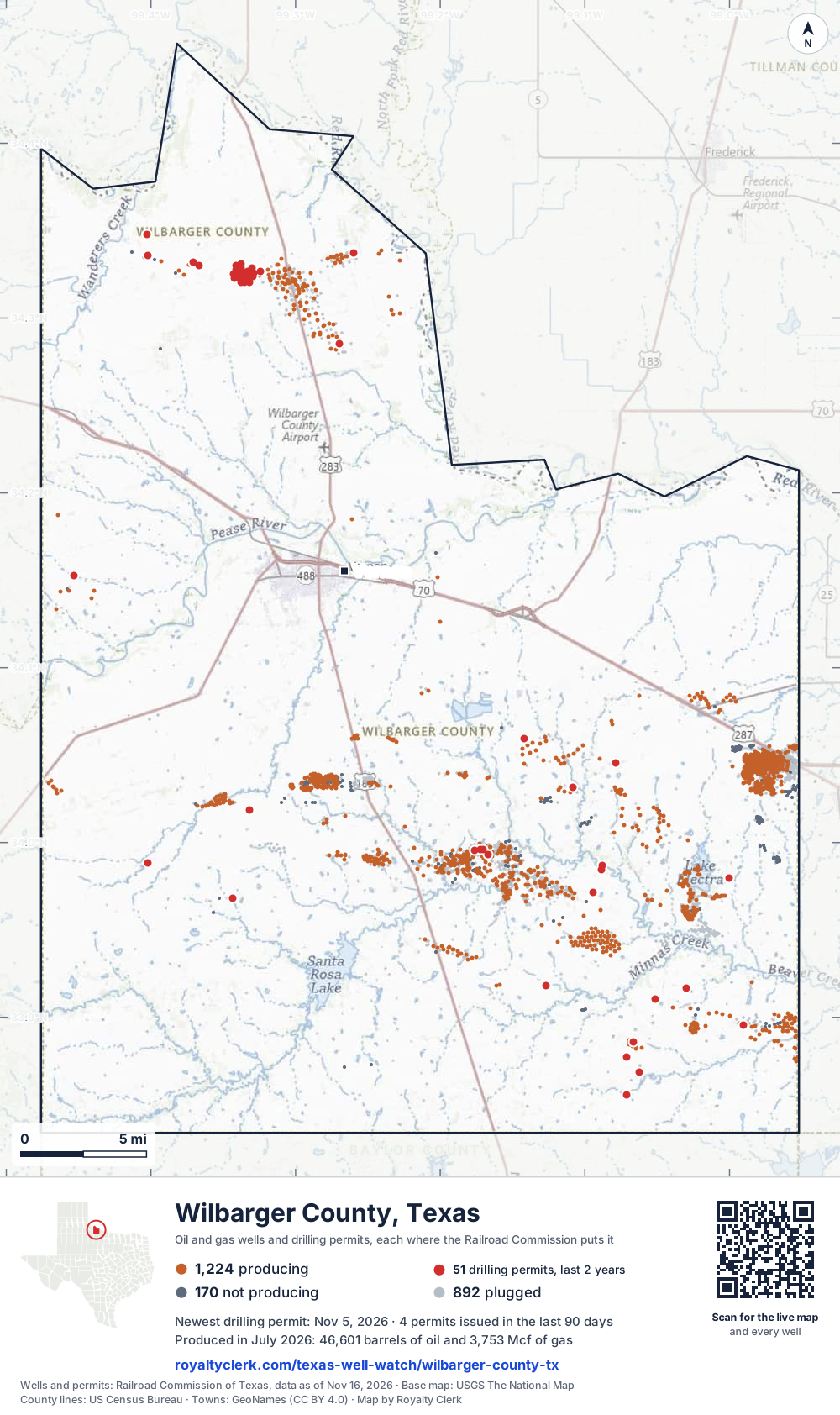
- Drilling locations51Permits issued in the last two years
- Producing wells1,224On a lease reporting production now
- Not producing170Shut in, inactive or no lease on record
- Plugged892The state's wellbore record says plugged
Sources: Railroad Commission of Texas well layers and permit files, US Census Bureau county outline, town points from GeoNames (CC BY 4.0), base map from USGS The National Map. A dot is a surface location; a horizontal well runs a mile or more from it.
2,286 wells with a location on the state's map and 51 drilling locations permitted in the last 24 months, each where the Railroad Commission puts it.
A permit is not a well.
Wells near each town in Wilbarger County
Wells within 10 miles of each town, on either side of the county line.
Use this map on your site
You may show this map on any site, unchanged. Keep the credit line and its link to Royalty Clerk under the map. The picture updates by itself as the state records new wells and permits.
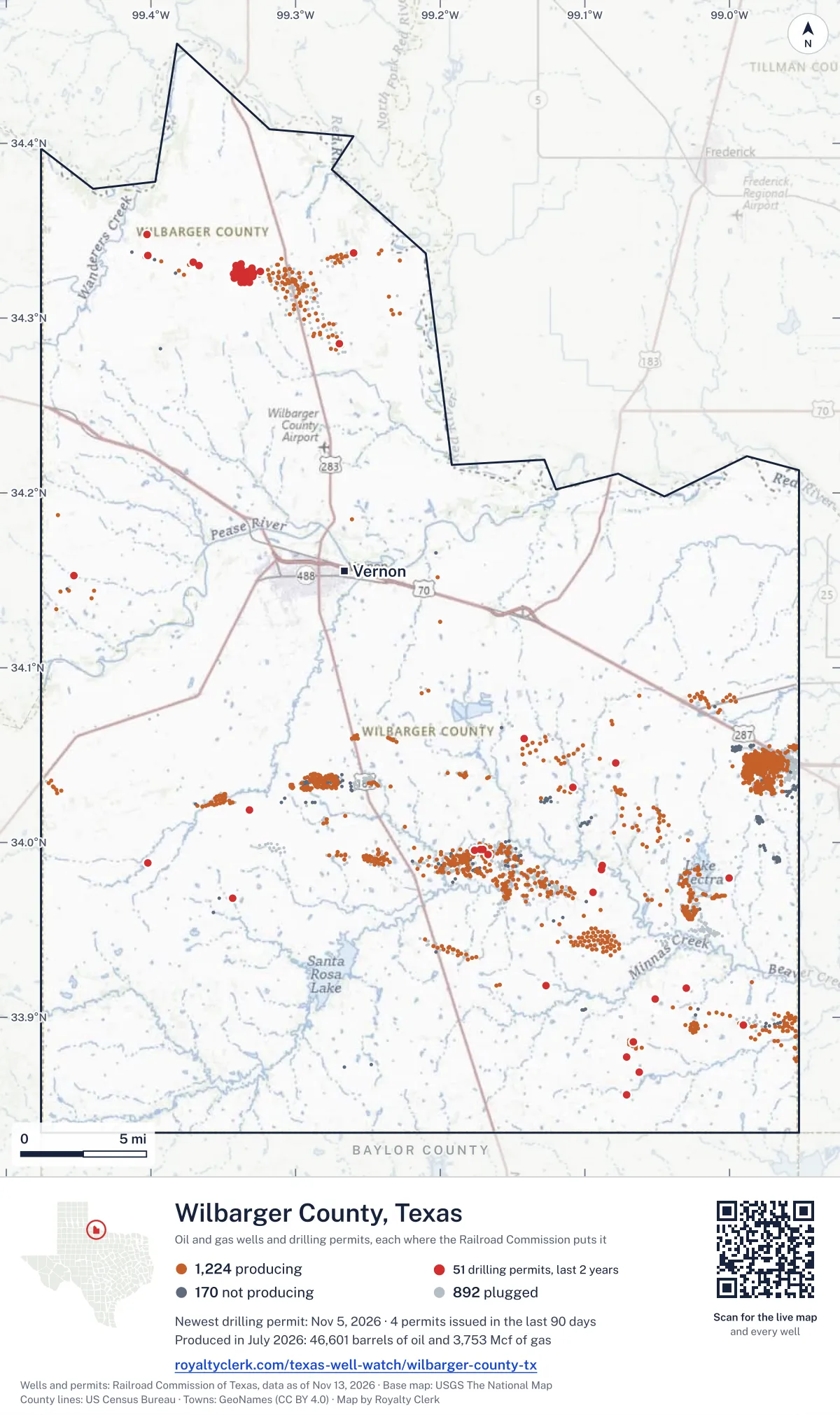
<a href="https://royaltyclerk.com/texas-well-watch/wilbarger-county-tx"><img src="https://royaltyclerk.com/maps/county-wells/wilbarger-county-tx.svg" alt="Map of Wilbarger County, Texas, with 2,286 oil and gas wells and 51 recent drilling locations as dots." width="1000" height="1684" loading="lazy" style="max-width:100%;height:auto;border:0"></a>
<p style="margin:4px 0 0;font-size:14px">Map: <a href="https://royaltyclerk.com/texas-well-watch/wilbarger-county-tx">Wilbarger County, Texas oil and gas wells</a> by Royalty Clerk, from Railroad Commission of Texas records</p>
The last twelve months
Month by month in Wilbarger County
| Month | Permits | Completions | First production |
|---|---|---|---|
| Nov 2026 | 1 | 0 | 0 |
| Oct 2026 | 1 | 0 | 0 |
| Sep 2026 | 2 | 0 | 0 |
| Aug 2026 | 12 | 0 | 0 |
| Jul 2026 | 10 | 0 | 0 |
| Jun 2026 | 4 | 1 | 1 |
| May 2026 | 0 | 1 | 0 |
| Apr 2026 | 1 | 0 | 1 |
| Mar 2026 | 3 | 1 | 0 |
| Feb 2026 | 0 | 1 | 0 |
| Jan 2026 | 1 | 1 | 0 |
Counted from November 17, 2025 to November 5, 2026, so the first and last months are partial. Source: Railroad Commission of Texas data sets.
Free, no sign-in
The newest drilling permits in Wilbarger County
| Issued | Lease and well | Operator | Drilling began | Depth, ft | API number | Coordinates | Permit |
|---|---|---|---|---|---|---|---|
| 2026-11-05 | WAGGONER SRNE 2SRnew drill · verticalWaggoner Operating, L.L.C.API 42-487-33431 · permit 091987833.96803, -99.343319,000 ft | Waggoner Operating, L.L.C. | |||||
| 2026-10-09 | DOANS 1new drill · verticalRiggins Energy, Inc.API 42-487-33430 · permit 091920834.33708, -99.259667,800 ft | Riggins Energy, Inc. | |||||
| 2026-09-29 | WAGGONER ROCK CREEK 551EPnew drill · verticalWaggoner Operating, L.L.C.API 42-487-33429 · permit 091894534.03167, -99.108184,000 ft | Waggoner Operating, L.L.C. | |||||
| 2026-09-25 | WAGGONER WEST HORSE 531EPnew drill · verticalWaggoner Operating, L.L.C.API 42-487-33428 · permit 091887934.04563, -99.078929,000 ft | Waggoner Operating, L.L.C. | |||||
| 2026-08-18 | SUMNER 2field transfer · verticalBurk Royalty Co., Ltd.API 42-487-32693 · permit 091767234.32986, -99.341248,900 ft | Burk Royalty Co., Ltd. | |||||
| 2026-08-12 | WHITEFISH B 1field transfer · verticalBurk Royalty Co., Ltd.API 42-487-33197 · permit 091773834.32358, -99.329698,900 ft | Burk Royalty Co., Ltd. | |||||
| 2026-08-12 | WHITEFISH A 2field transfer · verticalBurk Royalty Co., Ltd.API 42-487-33190 · permit 091773734.32580, -99.328978,900 ft | Burk Royalty Co., Ltd. | |||||
| 2026-08-12 | WHITEFISH A 1field transfer · verticalBurk Royalty Co., Ltd.API 42-487-33183 · permit 091773634.32665, -99.324198,900 ft | Burk Royalty Co., Ltd. | |||||
| 2026-08-12 | SUMNER HEIRS 5field transfer · verticalBurk Royalty Co., Ltd.API 42-487-33182 · permit 091773434.32857, -99.330338,900 ft | Burk Royalty Co., Ltd. | |||||
| 2026-08-07 | SUMNER 3field transfer · verticalBurk Royalty Co., Ltd.API 42-487-33299 · permit 091767334.32766, -99.341248,900 ft | Burk Royalty Co., Ltd. | |||||
| 2026-08-06 | HANNA TRUST 1field transfer · verticalBurk Royalty Co., Ltd.API 42-487-33181 · permit 091766834.32840, -99.337608,900 ft | Burk Royalty Co., Ltd. | |||||
| 2026-08-06 | WAGGONER SOUTH RED 362EPnew drill · verticalWaggoner Operating, L.L.C.API 42-487-33427 · permit 091758933.89567, -98.990155,000 ft | Waggoner Operating, L.L.C. | |||||
| 2026-08-04 | CONDON 1Ufield transfer · verticalBurk Royalty Co., Ltd.API 42-487-00024 · permit 091757234.32446, -99.338708,900 ft | Burk Royalty Co., Ltd. | |||||
| 2026-08-04 | CONDON 13field transfer · verticalBurk Royalty Co., Ltd.API 42-487-33388 · permit 091757134.32055, -99.335298,900 ft | Burk Royalty Co., Ltd. | |||||
| 2026-08-04 | CONDON 12field transfer · verticalBurk Royalty Co., Ltd.API 42-487-33298 · permit 091757034.32321, -99.339348,900 ft | Burk Royalty Co., Ltd. | |||||
| 2026-08-04 | CONDON 11field transfer · verticalBurk Royalty Co., Ltd.API 42-487-33270 · permit 091756934.32581, -99.339528,900 ft | Burk Royalty Co., Ltd. | |||||
| 2026-07-24 | CONDON 10field transfer · verticalBurk Royalty Co., Ltd.API 42-487-33269 · permit 091733434.32690, -99.332948,900 ft | Burk Royalty Co., Ltd. | |||||
| 2026-07-24 | CONDON 9field transfer · verticalBurk Royalty Co., Ltd.API 42-487-33180 · permit 091733334.32315, -99.335608,900 ft | Burk Royalty Co., Ltd. | |||||
| 2026-07-20 | CONDON 8field transfer · verticalBurk Royalty Co., Ltd.API 42-487-33169 · permit 091721334.32638, -99.33656drilling began 2018-10-01 · 8,900 ft | Burk Royalty Co., Ltd. | |||||
| 2026-07-17 | CONDON 7field transfer · verticalBurk Royalty Co., Ltd.API 42-487-33168 · permit 091721234.32590, -99.335608,900 ft | Burk Royalty Co., Ltd. | |||||
| 2026-07-10 | CONDON 6field transfer · verticalBurk Royalty Co., Ltd.API 42-487-33151 · permit 091701834.32429, -99.332878,900 ft | Burk Royalty Co., Ltd. | |||||
| 2026-07-10 | CONDON 5field transfer · verticalBurk Royalty Co., Ltd.API 42-487-33149 · permit 091701734.32030, -99.337758,900 ft | Burk Royalty Co., Ltd. | |||||
| 2026-07-06 | CONDON 4field transfer · verticalBurk Royalty Co., Ltd.API 42-487-33150 · permit 091685534.32061, -99.332138,900 ft | Burk Royalty Co., Ltd. | |||||
| 2026-07-06 | CONDON 3field transfer · verticalBurk Royalty Co., Ltd.API 42-487-33145 · permit 091685434.32389, -99.333218,900 ft | Burk Royalty Co., Ltd. | |||||
| 2026-07-02 | WAGGONER DN 19recompletion · verticalBurk Royalty Co., Ltd.API 42-487-32954 · permit 091687733.99592, -99.170402,575 ft | Burk Royalty Co., Ltd. | |||||
| 2026-07-01 | CADDIS 1field transfer · verticalBurk Royalty Co., Ltd.API 42-487-33325 · permit 091680034.32517, -99.342928,900 ft | Burk Royalty Co., Ltd. | |||||
| 2026-06-30 | CADDIS 2field transfer · verticalBurk Royalty Co., Ltd.API 42-487-33387 · permit 091680234.32267, -99.34238drilling began 2024-09-03 · 8,900 ft | Burk Royalty Co., Ltd. | |||||
| 2026-06-26 | WAGGONER DN 21recompletion · verticalBurk Royalty Co., Ltd.API 42-487-33032 · permit 091661833.99611, -99.172442,000 ft | Burk Royalty Co., Ltd. | |||||
| 2026-06-16 | SUMNER UNIT 1recompletion · verticalBurk Royalty Co., Ltd.API 42-487-32670 · permit 091642334.33092, -99.337518,900 ft | Burk Royalty Co., Ltd. | |||||
| 2026-06-03 | KESTER SWD 1new drill · verticalJamex, Inc.API 42-487-33426 · permit 091605734.34804, -99.402636,000 ft | Jamex, Inc. | |||||
| 2026-04-17 | THIEME 2204new drill · verticalDRY Fork Production Co., LLCAPI 42-487-33425 · permit 091434134.05936, -99.142125,000 ft | DRY Fork Production Co., LLC | |||||
| 2026-03-24 | GOTCHA 1new drill · verticalBurk Royalty Co., Ltd.API 42-487-33424 · permit 091433134.28548, -99.26986drilling began 2026-04-01 · 7,000 ft | Burk Royalty Co., Ltd. | |||||
| 2026-03-24 | WAGGONER SRND 1041SRnew drill · verticalWaggoner Operating, L.L.C.API 42-487-33423 · permit 091426834.01871, -99.33211drilling began 2026-05-05 · 6,000 ft | Waggoner Operating, L.L.C. | |||||
| 2026-03-24 | WAGGONER NWNE 101NNnew drill · verticalWaggoner Operating, L.L.C.API 42-487-33422 · permit 091424633.98823, -99.40206drilling began 2026-04-26 · 4,000 ft | Waggoner Operating, L.L.C. | |||||
| 2026-01-28 | BELEW UNIT 1new drill · verticalRiggins Energy, Inc.API 42-487-33421 · permit 091314434.32988, -99.36646drilling began 2026-05-19 · 7,200 ft | Riggins Energy, Inc. | |||||
| 2025-09-16 | WAGGONER SOUTH DIVING BOARD 361EPnew drill · verticalWaggoner Operating, L.L.C.API 42-487-33420 · permit 091042833.91826, -99.12716drilling began 2025-10-08 · 6,000 ft | Waggoner Operating, L.L.C. | |||||
| 2025-09-05 | BELL DDD 1new drill · verticalDDD Exploration, Inc.API 42-487-33419 · permit 091025234.15251, -99.45339drilling began 2025-10-10 · 9,000 ft | DDD Exploration, Inc. | |||||
| 2025-08-08 | WAGGONER GBEA 352GBnew drill · verticalWaggoner Operating, L.L.C.API 42-487-33418 · permit 090975133.98692, -99.08801drilling began 2026-05-18 · 6,000 ft | Waggoner Operating, L.L.C. | |||||
| 2025-07-17 | WAGGONER SOUTH TWIN PEAKS 61EPnew drill · verticalWaggoner Operating, L.L.C.API 42-487-33417 · permit 090930333.91662, -99.03011drilling began 2025-09-16 · 2,000 ft | Waggoner Operating, L.L.C. | |||||
| 2025-07-17 | WAGGONER WEST TWIN PEAKS 51EPnew drill · verticalWaggoner Operating, L.L.C.API 42-487-33416 · permit 090930233.91058, -99.05168drilling began 2025-09-09 · 2,000 ft | Waggoner Operating, L.L.C. | |||||
| 2025-07-17 | WAGGONER DN LONG CREEK 21EPnew drill · verticalWaggoner Operating, L.L.C.API 42-487-33415 · permit 090930133.85547, -99.07113drilling began 2025-09-02 · 2,000 ft | Waggoner Operating, L.L.C. | |||||
| 2025-07-17 | WAGGONER KITE 121EPnew drill · verticalWaggoner Operating, L.L.C.API 42-487-33414 · permit 090929933.86867, -99.06245drilling began 2025-08-27 · 2,000 ft | Waggoner Operating, L.L.C. | |||||
| 2025-07-17 | WAGGONER MRE 14MRnew drill · verticalWaggoner Operating, L.L.C.API 42-487-33413 · permit 090929833.87709, -99.07134drilling began 2025-08-21 · 2,000 ft | Waggoner Operating, L.L.C. | |||||
| 2025-04-14 | WAGGONER MCD 13MCnew drill · verticalWaggoner Operating, L.L.C.API 42-487-33412 · permit 090734333.88585, -99.06679drilling began 2025-05-13 · 2,000 ft | Waggoner Operating, L.L.C. | |||||
| 2025-02-27 | RCDSU #1 73recompletion · verticalBurk Royalty Co., Ltd.API 42-487-33090 · permit 090612133.99327, -99.16672drilling began 2025-04-01 · 1,999 ft | Burk Royalty Co., Ltd. | |||||
| 2025-02-21 | RCMSU #2 35recompletion · verticalBurk Royalty Co., Ltd.API 42-487-33068 · permit 090602433.99577, -99.17614drilling began 2015-06-04 · 2,685 ft | Burk Royalty Co., Ltd. | |||||
| 2025-02-07 | MARTIN 2new drill · verticalCLS Petroleum Holdings LLCAPI 42-487-33411 · permit 090573934.33193, -99.37103drilling began 2025-03-09 · 7,200 ft | CLS Petroleum Holdings LLC | |||||
| 2024-12-18 | WAGGONER EAST ELECTRA LAKE 71EPnew drill · verticalW.t. Waggoner Estate, Inc.API 42-487-33410 · permit 090475333.97985, -99.00011drilling began 2025-01-17 · 4,000 ft | W.t. Waggoner Estate, Inc. | |||||
| 2024-12-09 | WAGGONER GBEB 231GBnew drill · verticalW.t. Waggoner Estate, Inc.API 42-487-33409 · permit 090447933.97162, -99.09445drilling began 2024-12-22 · 6,000 ft | W.t. Waggoner Estate, Inc. | |||||
| 2024-12-02 | WAGGONER GBEA 351GBnew drill · verticalW.t. Waggoner Estate, Inc.API 42-487-33408 · permit 090430133.98441, -99.08861drilling began 2024-12-12 · 6,000 ft | W.t. Waggoner Estate, Inc. |
These are the newest 50 of 109 permits on file for Wilbarger County. The rest follow, 50 to a page.
A permit is permission to drill, not a well. Source: Railroad Commission of Texas drilling permit files.
Year by year
Drilling permits issued in Wilbarger County, by year
| Year | Permits issued |
|---|---|
| 2026 so far | 35 |
| 2025 | 12 |
| 2024 | 46 |
| 2023 | 13 |
| 2022 | 1 |
| 2021 | 2 |
Counted from the permit files we hold, which start in 2021; that first year may be partial. Source: Railroad Commission of Texas drilling permit files.
The latest
The most recent records
| Date | What, who and where |
|---|---|
| 2026-11-05 | Permit issued: Waggoner Operating, L.L.C.WAGGONER SRNE · A-520 · permit 0919878 |
| 2026-10-09 | Permit issued: Riggins Energy, Inc.DOANS · A-1489 · permit 0919208 |
| 2026-09-29 | Permit issued: Waggoner Operating, L.L.C.WAGGONER ROCK CREEK · A-119 · permit 0918945 |
| 2026-09-25 | Permit issued: Waggoner Operating, L.L.C.WAGGONER WEST HORSE · A-75 · permit 0918879 |
| 2026-08-18 | Permit issued: Burk Royalty Co., Ltd.SUMNER · A-623 · permit 0917672 |
| 2026-08-12 | Permit issued: Burk Royalty Co., Ltd.WHITEFISH B · A-1984 · permit 0917738 |
| 2026-08-12 | Permit issued: Burk Royalty Co., Ltd.WHITEFISH A · A-1984 · permit 0917737 |
| 2026-08-12 | Permit issued: Burk Royalty Co., Ltd.WHITEFISH A · A-1984 · permit 0917736 |
| 2026-08-12 | Permit issued: Burk Royalty Co., Ltd.SUMNER HEIRS · A-623 · permit 0917734 |
| 2026-08-07 | Permit issued: Burk Royalty Co., Ltd.SUMNER · A-623 · permit 0917673 |
| 2026-08-06 | Permit issued: Waggoner Operating, L.L.C.WAGGONER SOUTH RED · A-1611 · permit 0917589 |
| 2026-08-06 | Permit issued: Burk Royalty Co., Ltd.HANNA TRUST · A-623 · permit 0917668 |
| 2026-08-04 | Permit issued: Burk Royalty Co., Ltd.CONDON · A-1984 · permit 0917571 |
| 2026-08-04 | Permit issued: Burk Royalty Co., Ltd.CONDON · A-1984 · permit 0917570 |
| 2026-08-04 | Permit issued: Burk Royalty Co., Ltd.CONDON · A-1984 · permit 0917569 |
Follow it
Watch Wilbarger County, or one abstract
What do you want to follow?
Where the land is. Your deed or lease names it.
For example A-1119, or Bush, or T&P 38. Your deed or the tax bill has it.
Other counties
Drilling activity in other counties
Related
Related
- ToolTexas well watchPermit, completion, first production and when the first check is due.
- ToolIs this buyout offer fair?The offer as months of your income, what the acres mean, and the questions to ask.
- ToolIs this lease offer good?Bonus and royalty against the county, and a scan of the lease's clauses.
- Texas dataTexas operator changesWho took over whose leases in the last 24 months.
- ToolLate payment interestDeadlines and the interest a late payment earns.
- Texas dataTexas oil and gas atlas254 counties, every lease, operator and field.
FAQ
Questions people ask
How many wells were permitted in Wilbarger County in the last year?
The Railroad Commission issued 35 drilling permits in Wilbarger County in the twelve months to November 5, 2026, and recorded 5 completions and 2 first-production reports. A permit is permission to drill, not a well.
How do I get an alert when a permit is issued near my land in Wilbarger County?
Choose your abstract on this page, or the whole county, and sign in. You get one email a week, only when something new is recorded after you sign up. The alert says whether an event is on an interest in your Mineral File, on a place you follow, or only nearby.
When is my first royalty check due after a new well?
Natural Resources Code section 91.402(a) says on or before 120 days after the end of the month of first sale of production from the well. The state's first-production month is the closest public marker, so the date on this page is the earliest, not a certainty.
Got a new well on your land?
The first check is due within 120 days after the end of the month of first sale.
Sources
Primary sources, opened on 29 September 2026. Statute text is the current version on statutes.capitol.texas.gov.