
RRC field 12800001 · District 09
Bryson, East
The Bryson, East field reported 80,887 barrels of oil and 42,767 mcf of gas in the last 12 months.
Field dossier
- Producing leases
- 32of 59 on record
- Operators
- 17
- Counties
- 2
- Biggest operator
- Oakridge Oil and Gas, LP
Own minerals in this field?
A family member owned minerals here?
Search their name: a family member who owned minerals hereWhere the field sits
fewermore
- Gas, last 12 months
- 42,767 mcf
- Data through
- Jul 2026
Wells in the Bryson, East field

- Drilling locations16Permits issued in the last two years
- Producing wells62On a lease reporting production now
- Not producing23Shut in, inactive or no lease on record
- Plugged72The state's wellbore record says plugged
Each dot is a well on a lease the Railroad Commission lists in the Bryson, East field, where its map puts it, or a drilling permit filed for the field in the last 24 months. Wells of other fields are not on this map. The picture is about 34 miles across. Sources: Railroad Commission of Texas well layers and drilling permit files, US Census Bureau county outlines, town points from GeoNames (CC BY 4.0).
Use this map on your site
You may show this map on any site, unchanged. Keep the credit line and its link to Royalty Clerk under the map. The picture updates by itself as the state records new wells and permits.
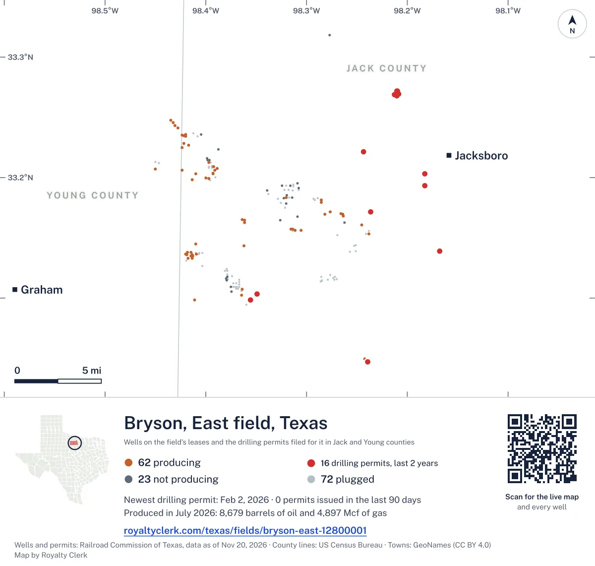
<a href="https://royaltyclerk.com/texas/fields/bryson-east-12800001"><img src="https://royaltyclerk.com/maps/field-wells/bryson-east-12800001.svg" alt="Map of the wells of the Bryson, East field, Texas: 157 wells and 16 recent drilling locations, in a picture about 34 miles across." width="1000" height="951" loading="lazy" style="max-width:100%;height:auto;border:0"></a>
<p style="margin:4px 0 0;font-size:14px">Map: <a href="https://royaltyclerk.com/texas/fields/bryson-east-12800001">Oil and gas wells of the Bryson, East field, Texas</a> by Royalty Clerk, from Railroad Commission of Texas records</p>
Oil has led Bryson, East in every full year
Bryson, East is a field of 59 leases in Jack and Young counties, and Oakridge Oil and Gas, LP accounts for 75.0% of its output. Oil made more of the output than gas in every full calendar year from 1993 to 2025. The field's 32 producing leases hold 89 wells, and none of them is horizontal.
In January 1993, Stamper Operating Co., Inc., Pyramid Energy, Inc. and Catlin, Cecil Oil Co. led the leases on record. Oakridge Oil and Gas, LP now holds five leases first reported from 2020 on.
The state received 7 drilling permits for the field in the last 12 months, and none is horizontal. The biggest full calendar year was 1993, with 94,557 barrels of oil and 200,293 mcf of gas.
Not a forecast, not reserves.
Key moments
- 1993Biggest full calendar year: 94,557 barrels of oil and 200,293 mcf of gas.
- 2014Oil fell to 49,631 barrels in 2014 from 68,347 in 2013.
- 2020Leases reporting fell from 52 in 2019 to 30 in 2020.
- 2021Gas rose to 50,262 mcf in 2021 from 39,299 in 2020.
- 2025Oil rose to 44,762 barrels in 2025 from 23,504 in 2024.
If you own here
- Find the land on my deed
The field spans Jack and Young counties and its producing leases hold 89 wells; find your land on the survey map.
- Mineral interest finder
Seventeen operators report in this field, so search your name to see which county leases carry it.
- Royalty calculator
Oil made more of the output than gas in every full calendar year from 1993 to 2025; estimate a check from oil volume and price.
Questions owners ask
- Why is Oakridge Oil and Gas, LP's name on the field's reports?
- Oakridge Oil and Gas, LP has the largest share of the field's output, at 75.0% in barrels of oil equivalent. It runs 4 producing leases here and holds five leases first reported from 2020 on. Its oil and gas both appear on the field's reports.
- How can I tell if my lease is in this field?
- Check the county and lease number against the field's lease list. Jack County has 28 producing leases in this field, and Young County has 4. The land abstract search finds a section, block or abstract number on a survey map. Find the land on my deed
- How has oil changed in the most recent full years?
- Oil rose to 44,762 barrels in 2025 from 23,504 in 2024. In 2014 oil fell to 49,631 barrels from 68,347 in 2013. Oil made more of the output than gas in every full calendar year from 1993 to 2025.
- Are any wells in this field horizontal?
- None. The field has 89 wells on its producing leases, and none is horizontal. The state received 7 drilling permits in the last 12 months, and none of them is horizontal.
Related pages
- Oakridge Oil and Gas, LP
Runs 4 producing leases here and holds 75.0% of the field's output.
- D L Operating
Operates 8 producing leases here, including the oldest producing lease.
- Gahagan, C. P.
Oldest producing lease in the field, first reported January 1993.
- Jack County
Jack County holds 28 producing leases from this field.
- Young County
Young County holds 4 producing leases from this field.
From the state's records through July 2026.
Five years of oil and gas, month by month
Oil output in the Bryson, East field rose 154% over the last 12 months
80.9k bbl through Jul 2026, against 31.9k bbl a year earlier. Peak Mar 2026: 9,061 bbl.
Gas output in the Bryson, East field rose 13% over the last 12 months
42.8k mcf through Jul 2026, against 37.9k mcf a year earlier. Peak Mar 2026: 5,220 mcf.
SourceTexas Railroad Commission Production Data Query, field 12800001, through Jul 2026, file dated Oct 20, 2026.
Leases stopped and started since 2020
Under each volume: change on the year before.
34,584bbl oiln/a
29,721bbl oiln/a
4,279bbl oil−12%
4,015bbl oil−4%
1,241bbl oil−25%
1,151bbl oiln/a
955bbl oil−4%
934bbl oil+97%
792bbl oil−23%
- MARLEY
09-26444Barnett, G.Jack County
768bbl oil+6%
724bbl oil−8%
643bbl oil−7%
611bbl oil0%
562bbl oil−14%
478bbl oil−9%
416bbl oil−26%
378bbl oil+8%
281bbl oil+8%
269bbl oil+35%
268bbl oil+37%
254bbl oil−55%
253bbl oil−17%
218bbl oil−34%
171bbl oil+10%
127bbl oil−48%
Showing 25 of 32, ranked by output value.
SourceTexas Railroad Commission Production Data Query.
Who operates Bryson, East and where
Operators, by oil
Oakridge Oil and Gas leads
- Oakridge Oil and Gas, LP4 leases64.9kbbl
- Rio Bravo Production, LLC3 leases4,925bbl
- Greco Operating, LLC1 lease4,015bbl
- D L Operating8 leases2,184bbl
- Covenant Operating, LLC2 leases1,747bbl
- New Horizon Resources LLC2 leases1,494bbl
- Pryor Petroleum Corporation2 leases1,152bbl
- FX Energy Operating, LLC1 lease1,151bbl
Counties, by oil
Jack County leads
Drilling permits filed in the last 12 months
RICHARDS RANCH #W 51
recompletion · FX Energy Operating, LLC · Jack County
Permit 0913081 · Feb 2, 2026
R. L. MARTIN #O 4
re-entry · Oakridge Oil and Gas, LP · Jack County
Permit 0912485 · Jan 8, 2026
RICHARDS RANCH #N 19
recompletion · FX Energy Operating, LLC · Jack County
Permit 0911660 · Nov 14, 2025
RICHARDS RANCH #13
recompletion · FX Energy Operating, LLC · Jack County
Permit 0910968 · Oct 10, 2025
LOWRANCE UNIT #3
new drill · Boss Operating LLC · Jack County
Permit 0910620 · Sep 24, 2025
PEAVY #O 14
new drill · Oakridge Oil and Gas, LP · Jack County
Permit 0910379 · Sep 16, 2025