
RRC field 27135750 · District 02
Eagleville (Eagle Ford-2)
The Eagleville (Eagle Ford-2) field reported 121 million barrels of oil and 322 million mcf of gas in the last 12 months.
Field dossier
- Producing leases
- 2,707of 3,193 on record
- Operators
- 26
- Counties
- 7
- Biggest operator
- Burlington Resources O & G Co LP
Own minerals in this field?
A family member owned minerals here?
Search their name: a family member who owned minerals hereWhere the field sits
fewermore
- Gas, last 12 months
- 322,182,018 mcf
- Data through
- Aug 2026
Wells in the Eagleville (Eagle Ford-2) field

- Drilling locations665Permits issued in the last two years
- Producing wells6,628On a lease reporting production now
- Not producing529Shut in, inactive or no lease on record
- Plugged63The state's wellbore record says plugged
Each dot is a well on a lease the Railroad Commission lists in the Eagleville (Eagle Ford-2) field, where its map puts it, or a drilling permit filed for the field in the last 24 months. Wells of other fields are not on this map. The picture is about 149 miles across. The white counties are the ones with a well or drilling permit of the field on the map. Sources: Railroad Commission of Texas well layers and drilling permit files, US Census Bureau county outlines, town points from GeoNames (CC BY 4.0).
Use this map on your site
You may show this map on any site, unchanged. Keep the credit line and its link to Royalty Clerk under the map. The picture updates by itself as the state records new wells and permits.
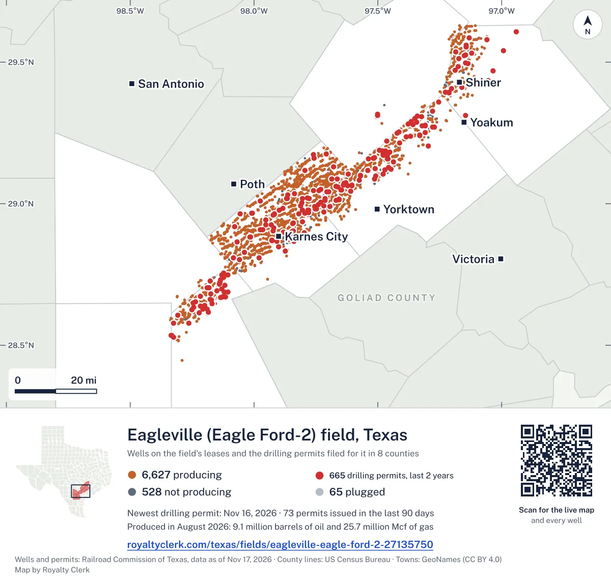
<a href="https://royaltyclerk.com/texas/fields/eagleville-eagle-ford-2-27135750"><img src="https://royaltyclerk.com/maps/field-wells/eagleville-eagle-ford-2-27135750.svg" alt="Map of the wells of the Eagleville (Eagle Ford-2) field, Texas: 7,220 wells and 665 recent drilling locations, in a picture about 149 miles across." width="1000" height="951" loading="lazy" style="max-width:100%;height:auto;border:0"></a>
<p style="margin:4px 0 0;font-size:14px">Map: <a href="https://royaltyclerk.com/texas/fields/eagleville-eagle-ford-2-27135750">Oil and gas wells of the Eagleville (Eagle Ford-2) field, Texas</a> by Royalty Clerk, from Railroad Commission of Texas records</p>
Five years of output in Eagleville (Eagle Ford-2)
Oil output in the Eagleville (Eagle Ford-2) field fell 9% over the last 12 months
121M bbl through Aug 2026, against 133M bbl a year earlier. Peak Jul 2025: 12M bbl.
Gas output in the Eagleville (Eagle Ford-2) field fell 5% over the last 12 months
322M mcf through Aug 2026, against 340M mcf a year earlier. Peak Jul 2025: 32M mcf.
SourceTexas Railroad Commission Production Data Query, field 27135750, through Aug 2026, file dated Oct 20, 2026.
Leases in the Eagleville (Eagle Ford-2) field
Under each volume: change on the year before.
1,522,795bbl oiln/a
1,217,108bbl oiln/a
1,141,955bbl oiln/a
1,002,065bbl oil−41%
879,064bbl oil+284%
867,129bbl oil+886%
854,075bbl oil+338%
792,713bbl oiln/a
724,501bbl oil−58%
707,212bbl oiln/a
679,347bbl oiln/a
643,333bbl oil−14%
621,241bbl oil+173%
603,031bbl oil+78%
594,431bbl oiln/a
584,586bbl oil+28%
573,869bbl oiln/a
453,310bbl oil+592%
405,265bbl oiln/a
400,775bbl oil+217%
397,605bbl oiln/a
395,167bbl oil+55%
392,205bbl oil0%
390,991bbl oiln/a
- GEFFERT A-GWOSDZ A SA 1
385,575bbl oiln/a
Showing 25 of 150 (the 150 largest of 2,707), ranked by output value.
SourceTexas Railroad Commission Production Data Query.
Who operates here, and where
Operators, by oil
Burlington Resources O & G Co leads
- Burlington Resources O & G Co LP569 leases38Mbbl
- BPX Operating Company391 leases19Mbbl
- Devon Energy Production Co, L.P.282 leases19Mbbl
- EOG Resources, Inc.342 leases12Mbbl
- Marathon Oil Ef LLC386 leases10Mbbl
- FW Eagle Ford I, LLC286 leases7.7Mbbl
- Murphy Expl. & Prod. Co. - USA75 leases4.1Mbbl
- Verdun Oil & Gas LLC120 leases3.8Mbbl
Counties, by oil
Karnes County leads
Recent drilling permits in the Eagleville (Eagle Ford-2) field
MARGARET UNIT 2-PETERSON C #101H
new drill · horizontal · Silver Hill Energy Operating LLC · Karnes County
Permit 0919959 · Nov 13, 2026
MARGARET UNIT 2-PETERSON C #002H
new drill · horizontal · Silver Hill Energy Operating LLC · Karnes County
Permit 0919958 · Nov 13, 2026
MARGARET UNIT 1-PETERSON D #003H
new drill · horizontal · Silver Hill Energy Operating LLC · Karnes County
Permit 0919967 · Nov 12, 2026
MARGARET UNIT 1 #102H
new drill · horizontal · Silver Hill Energy Operating LLC · Karnes County
Permit 0919966 · Nov 12, 2026
MCCREARY SA B #2UH
new drill · horizontal · FW Eagle Ford I, LLC · Lavaca County
Permit 0919899 · Nov 10, 2026
MCCREARY SA A #1UH
new drill · horizontal · FW Eagle Ford I, LLC · Lavaca County
Permit 0919895 · Nov 10, 2026