
Texas oil fieldField 91571899District 03Through July 2026
Trull (8900)Matagorda County
The Trull field sold 876 barrels of oil in the last 12 months, from 1 lease.
In this photoCharolaisSurface spot, no path on record
The story, from 180 months of reports
How Trull (8900) turned from gas to oil in 2018
Trull (8900) is a Matagorda County field that turned from gas to oil in 2018. Gas led in 2011 and 2012, then again from 2014 to 2017. In 2014, the full calendar year that produced the most, the field reported 37,689 bbl of oil and 444,817 mcf of gas.
Charolais Energy, LLC runs the field now. Its one producing lease, Gresham Gas Unit, first reported production in August 2011.
The field's one producing well is not horizontal. No gas was reported in 2024 or 2025. Oil was still reported in both years.
Not a forecast, not reserves.
Key moments
- August 2011Gresham Gas Unit first reports production; Charolais Energy runs it now.
- 2014Biggest full calendar year: 37,689 bbl of oil, 444,817 mcf of gas.
- 2018Oil takes the lead over gas; the field turns from gas to oil.
- 2019Leases reporting falls from two to one.
- 2023Gas reports 1,793 mcf, down from 14,413 mcf in 2022.
- 2024No gas reported in 2024; oil reports 2,675 bbl.
SourceRailroad Commission production reports for every lease filed under field 91571899, August 2011 to July 2026. What the field has sold. Not a forecast, not reserves. Reported through July 2026.
Where the field sits
1 well in Matagorda County
Every well the State files under the Trull, drawn where its records put it. A well with a recorded bottom hole has a line to it. Wells with only a surface location appear as points. Colour the map by the company that operates each well, by how deep it runs, or see where drilling is headed.
Charolais
1 operator. It has a colour. Tap a pad to see whose it is, or pick a county.
What is on the map
Drilling locations: counted from the map as it loads
Leases by county
Wells near a town
Open the full well map

- Drilling locations0Permits issued in the last two years
- Producing wells1On a lease reporting production now
- Not producing0Shut in, inactive or no lease on record
- Plugged0The state's wellbore record says plugged
Each dot is a well on a lease the Railroad Commission lists in the Trull (8900) field, where its map puts it, or a drilling permit filed for the field in the last 24 months. Wells of other fields are not on this map. The picture is about 6 miles across. The white counties are the ones with a well or drilling permit of the field on the map. The thin brown lines are the original land surveys; where there is room, a survey carries its abstract number, the number deeds and division orders cite. Sources: Railroad Commission of Texas well layers, drilling permit files and survey lines, US Census Bureau county outlines.
Use this map on your site
You may show this map on any site, unchanged. Keep the credit line and its link to Royalty Clerk under the map. The picture updates by itself as the state records new wells and permits.
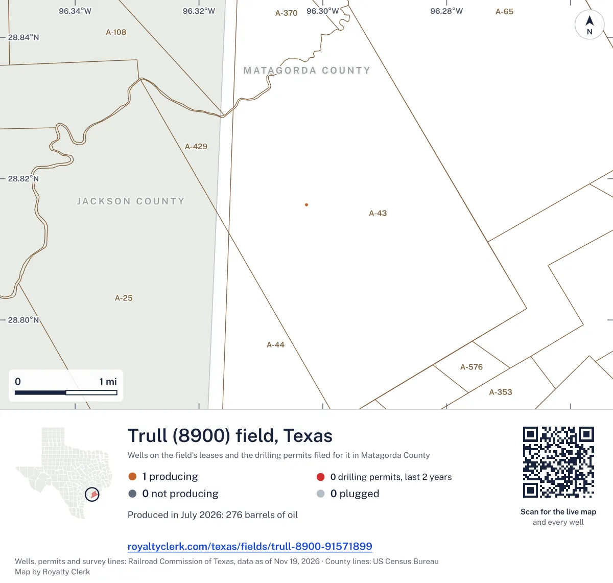
<a href="https://royaltyclerk.com/texas/fields/trull-8900-91571899"><img src="https://royaltyclerk.com/maps/field-wells/trull-8900-91571899.svg" alt="Map of the wells of the Trull (8900) field, Texas: 1 well and 0 recent drilling locations, in a picture about 6 miles across." width="1000" height="951" loading="lazy" style="max-width:100%;height:auto;border:0"></a>
<p style="margin:4px 0 0;font-size:14px">Map: <a href="https://royaltyclerk.com/texas/fields/trull-8900-91571899">Oil and gas wells of the Trull (8900) field, Texas</a> by Royalty Clerk, from Railroad Commission of Texas records</p>SourcesWells, well paths, operators, permits and drilling dates: Railroad Commission of Texas. Map depth bands: true vertical depth from FracFocus. County lines: U.S. Census Bureau. The dashed line is drawn around the wells; the State keeps no outline for a field. Record dated November 19, 2026. Roll-up counted November 18, 2026.
Watch Private covers the land around yours: it tells you the day a permit or a frac lands within a mile.See Watch Private
From each well's Railroad Commission recordNew
Total depth along the wellbore
Total depth measures the full length of the drilled hole, including bends and horizontal sections. Each tick is one well's total depth on its completion record, shallowest first. The field summary has no true vertical depth from FracFocus.
One well has a total depth on record: 9,750 feet as filed.
feet: the well's completed total depth on record, along the hole as filed. That is 1.85 miles of hole.
well has a completed total depth on record: every well on the field's leases.
Why no rock names: the State's well records give a well's total depth in feet and file the well under its field, not under the rock layer it produces from. So the drawing marks depths, never formations.
SourcesCompleted depth: the total depth on each well's own Railroad Commission well record, matched by API number whatever lease lists the well, one per API number, in whole feet as filed. Completed August 24, 2011 (the earliest completion date on the well's record). 1 of the field's 1 well has a completed total depth on record; a well without one is not drawn.
For mineral owners, from the state record
What Trull owners ask
- 01What is the Trull field?
- Trull (8900) is the name the Railroad Commission files these leases under: field 91571899, district 03. The State files every lease under a field. The field on your statement names the rock your wells produce from, not the town they are near.
- Source: Railroad Commission of Texas field list, field 91571899, district 03.
- See wellbore depths
- 02Is my lease in the Trull?
- 1 lease reports to this field, in Matagorda County. A lease can report to two fields when its wells reach different rock, and then it has a page under each. Search the lease name on your check stub to see which fields it reports to.
- Source: Railroad Commission production reports, field of record for each lease.
- Find my lease
- 03Who pays royalties in the Trull?
- 1 operator reported production from the field in the last 12 months. The one that pays you is the company named on your check stub. Charolais Energy, LLC runs the field's one producing lease.
- Source: Railroad Commission production reports, operator of record.
- See the operator
- 04Why did my Trull check go down?
- Oil sold▼ 46.4%Oil price▲ 6.53%
- Across the field, oil sold is down 46.4% on the 12 months before and the oil price is up 6.53%. A check can move with the field's volume and the price with nothing wrong on the lease. The statement check tells the two apart.
- Source: Railroad Commission production reports; U.S. Energy Information Administration prices.
- Why is my check lower?
- 05How much has the field's gas changed since 2014?
- Gas reached 444,817 mcf in 2014, the full calendar year that produced the most. It fell in every full year from 2015, to 1,793 mcf in 2023. No gas was reported in 2024 or 2025.
- 06Who runs the field now?
- Charolais Energy, LLC is the only operator shown for the field now. Its producing lease, Gresham Gas Unit, first reported production in August 2011. The operator page lists the company in more detail.
- 07Does the field have horizontal wells?
- No. The field has one producing well, and it is not horizontal. The record shows a horizontal share of 0.0% for the field's wells, so no horizontal wells are shown here.
180 months against seven other recordsNew
Every month since August 2011, and what else happened that month
The whole field is the line on top. Under it, on the same clock: the weather, the price, how many leases reported, new wells, takeovers, State cut-offs and leases that went silent. Move across it.
Oil averaged $80.46 a barrel · 1 lease reporting
- PriceThe oil price averaged $80.46 a barrel, down 19.8% on the three months before.
Move the pointer or drag across the chart. The numbered buttons jump to each month.
Monthly oil sold from the Trull (8900) field since August 2011, with the record tracks beneath it on the same clock. 180 months from August 2011 to July 2026. The most in one month: 5,145 barrels, November 2011. The newest month: 276 barrels. 6 months with nothing reported. Moments marked: 1, May 2012; 2, Aug 2012; 3, Jun 2014; 4, Nov 2015; 5, Mar 2016; 6, Oct 2019.
SourcesProduction, leases, new wells, takeovers, cut-offs and silent leases: Railroad Commission of Texas. Weather: NOAA Storm Events (file dated Oct 26, 2026) and NOAA daily county lows observed through Feb 21, 2026. Prices: U.S. Energy Information Administration (WTI for oil, Henry Hub for gas). Nothing on record in these months for: silent. A record in the same month is not proof of a cause. Reported through July 2026. Roll-up counted November 18, 2026.
Royalty Watch tells you the month your own lease starts to drop, with the records from that month.See Royalty Watch
16 years of state records, 2011 to 2026
Sold since August 2011
$25.7 million
What the field's oil and gas sold for at each month's public prices, before tax and the operators' deductions.
- Oil sold
- 272,766barrels
- Gas sold
- 1.68 billioncubic feet
- Best year
- 2014$5.5 million sold
| Year | Oil, dollars | Gas, dollars | Total |
|---|---|---|---|
| 2011, to July | $1.5 million | $348,000 | $1.9 million |
| 2012 | $3 million | $515,000 | $3.5 million |
| 2013 | $3.3 million | $652,000 | $3.9 million |
| 2014 | $3.5 million | $1.9 million | $5.5 million, sold the most |
| 2015 | $2.1 million | $911,000 | $3 million |
| 2016 | $736,000 | $334,000 | $1 million |
| 2017 | $704,000 | $271,000 | $976,000 |
| 2018 | $1.1 million | $237,000 | $1.3 million |
| 2019 | $811,000 | $135,000 | $947,000 |
| 2020 | $610,000 | $55,000 | $665,000 |
| 2021 | $879,000 | $70,000 | $950,000 |
| 2022 | $827,000 | $95,000 | $922,000 |
| 2023 | $399,000 | $5,000 | $404,000 |
| 2024 | $205,000 | $0 | $205,000 |
| 2025 | $49,000 | $0 | $49,000 |
| 2026, to July | $75,000 | $0 | $75,000 |
For research and teaching
Royalty Clerk. “Trull (8900) field, Texas.” Data through July 2026, from Railroad Commission of Texas filings. royaltyclerk.com/texas/fields/trull-8900-91571899.
SourcesRailroad Commission Production Data Query, every monthly report since August 2011. EIA monthly WTI and Henry Hub prices. 2026 is part of a year, drawn lighter. Not a forecast, not reserves. Reported through July 2026.
1 producing lease
Which lease still produces in Trull (8900)
The lease, its operator and county, and what else the records hold for it.
| Lease | Operator | County | Oil soldbarrels, 12 months to Jul 2026 | Changeon the 12 before | 24 months | Also on record |
|---|---|---|---|---|---|---|
| GRESHAM GAS UNITCharolais Energy, LLC · Matagorda | Charolais Energy, LLC | Matagorda | 876 bbl | ▼ 46.4% | Nothing else |
Showing 1 of 1.
Search every Texas leaseSourceTexas Railroad Commission Production Data Query, field 91571899, through July 2026, file dated Oct 20, 2026.
1 operator, one county
Who runs Trull (8900) now, in Matagorda County
Charolais Energy, LLC operates every lease that reported oil in the last 12 months, all in Matagorda County.
By oil in the last 12 months
- 1Charolais Energy, LLC876bbl1 lease · 100% of the field's oil · Matagorda
SourceTexas Railroad Commission Production Data Query, operator of record for each lease, through July 2026. Record dated October 20, 2026.
Oil prices and taxNew
What oil sold for in the 12 months through July 2026
a barrel, West Texas Intermediate, the average of the 12 months through July 2026, up 6.53% on the 12 before.
The tax office's price for each lease of this field shows here once the Comptroller's records for it arrive. Leases sell at different points and qualities, so their prices differ from the market for ordinary reasons too.
West Texas Intermediate, the 12 months through July 2026
No operator here reports a price to investors on file.
Not on file here yet. It shows once the Comptroller's records for this field arrive.
The price on your own check stub, set beside these three. Check my statement
SourcesMarket: U.S. Energy Information Administration, West Texas Intermediate. A lease shows only where the Comptroller's records have arrived. Reported through October 2026. Roll-up counted November 18, 2026.
Watch Plus sets these prices beside the price on each of your statements, every month.See Watch Plus
Buyers and gatherersNew
1 lease with a gas purchaser on file
The filings name gas purchasers. Reported production and current purchaser allocations do not establish an operator share for the period shown.
Current Form P-4 filings and companies
Gas purchasers
1 lease across 1 current entry on Form P-4.
- ENTERPRISE HYDROCARBONS, L.P. · 1 lease
Common ownership with the operator is unconfirmed in the company records checked.
Latest P-4 source dateGas purchasers buy casinghead gas or gas-well gas. Oil gatherers collect oil for transport. Each lease counts once in each role, even if several companies or gas products are listed. The company lists show up to five parties by lease count. A lease can appear under more than one company.
SourcesRailroad Commission of Texas, Form P-4. Counts measure distinct leases on current filings. Common ownership uses reviewed company filings. Latest P-4 source date .
Royalty Watch tells you the day the buyer of your oil or gas changes.See Royalty Watch
Seen from space, 2025New
No matched night observations on file for the field's leases
Weather satellites pass over Texas every night and record heat on the ground. No night observation in 2025 is matched to this field's leases on file here, and the satellites' coverage of these wells is unverified, so this is not a finding that there was no heat.
SourcesHeat: VIIRS active fire readings at night from NOAA-20, NOAA-21 and Suomi NPP (NOAA open data), matched to a lease's wells; a GOES-East reading alone never counts as a night. Satellite record read to Nov 16, 2026. Reported flaring and gas use: Railroad Commission production reports. Cloud hides heat, so the count is a floor. The satellite records heat. It does not say what burned. Roll-up counted November 18, 2026.
Watch Plus checks whether you were paid on gas in the months heat was seen at your lease.See Watch Plus
Well stages
Wells between permit and first production
A comparison of permits, drilling and fracs is unavailable for this field. No drilling permit for this field is among the State permit records read here.
SourceRailroad Commission drilling permits and FracFocus. Checked for the Trull field. Source date unavailable. Roll-up counted November 18, 2026.
Royalty Watch tells you the day a well on your lease moves to its next stage.See Royalty Watch
Do your Trull checks match the State?
Own minerals here? Add your leases to My leases and see your share of every month.
Example
A whole month was never paid
The State shows 28,175 barrels of oil sold from the lease in the month its operator changed from Operator A to Operator B, so the owner's share is 27.51 barrels. No statement covers that month.
Ask Operator B's owner relations: is that month held in suspense after the change of operator?
$2,277oil and gas
A sample finding, from our example check.
Around this field
Nearby
Fields nearby
- Bucks Bayou (Frio Tex 2)10 leases
- Markham8 leases
- Potthast (Middle Tex Miss)8 leases
- Duncan Slough (Frio Cons.)6 leases
- Bay City (7000 Frio)3 leases
Towns
- Palacios1 well within 10 miles
Related pages
- Charolais Energy, LLCCharolais Energy, LLC runs the field's one producing lease now.
- Matagorda CountyMatagorda County is the only county where this field reports.
- Gresham Gas UnitGresham Gas Unit first reported production in August 2011.
More
- Texas fields, A to ZEvery field with producing leases in Railroad Commission records.
- Check a stub against a leaseMatch the barrels and mcf on your stub to the state record.
Where this page comes from
- Railroad Commission of Texas production, Form P-4, permits, wells, completions, cut-offs
- U.S. Energy Information Administration prices
- NOAA storms and cold
- NOAA open data VIIRS night heat (NOAA-20, NOAA-21, Suomi NPP)
- U.S. Geological Survey photo from the air
- U.S. Census Bureau county shapes