
Texas oil lease
StoppedDIAL
Dial is an oil lease in Ochiltree County, Texas, in the Farnsworth, East (Oswego) field. It stopped producing after December 2022. The last sale was reported in October 2023, after the last gas produced in December 2022; nothing has been reported for 2 years 10 months since. Courson Oil & Gas, Inc was its last operator.
This lease has stopped
The last sale was reported in Oct 2023, after the last gas produced in Dec 2022.
- Last operator
- Courson Oil & Gas, Inc.
- County
- Ochiltree County
- RRC lease
- 10-08059
Is your family on this lease?
Where it sits
This county
- Silent for
- 2 years 10 months
- First report
- May 2009
Dial, 2009–2026
Its whole life in the Railroad Commission’s monthly reports, which start in January 1993; it first reported in May 2009. The last sale was reported in Oct 2023, after the last gas produced in Dec 2022. Royalty owners and their heirs can still be on the county roll after the checks stop.
- First reportMay 2009
- Best year2011$285,000 sold
- Last operatorCourson Oil & Gas, Inc.from Jan 2020
- Last gas producedDec 2022
- Last sale reportedOct 2023
- Silent for2 years 10 monthsthrough Aug 2026
- Oil sold since May 2009
- 13,035barrels
- Gas sold since May 2009
- 394,056thousand cubic feet (mcf)
- Sold for, in all
- $2.3 millionat each month's public prices, 100% of the lease
Source: Texas Railroad Commission production reports since January 1993 (oil and gas sold); EIA prices, through August 2026.
Every year as a table
| Year | Months | Oil sold, bbl | Gas sold, mcf | Sold for |
|---|---|---|---|---|
| 2026 * | 0 | 0 | 0 | $0 |
| 2025 | 0 | 0 | 0 | $0 |
| 2024 | 0 | 0 | 0 | $0 |
| 2023 | 12 | 44 | 0 | $3,768 |
| 2022 | 12 | 0 | 26,733 | $171,251 |
| 2021 | 12 | 192 | 29,782 | $132,988 |
| 2020 | 12 | 0 | 27,301 | $55,690 |
| 2019 | 12 | 0 | 26,807 | $68,811 |
| 2018 | 12 | 358 | 29,615 | $118,000 |
| 2017 | 12 | 735 | 30,250 | $128,663 |
| 2016 | 12 | 1,290 | 32,304 | $133,149 |
| 2015 | 12 | 925 | 25,101 | $113,735 |
| 2014 | 12 | 930 | 28,148 | $193,989 |
| 2013 | 12 | 1,451 | 33,120 | $265,468 |
| 2012 | 12 | 1,808 | 34,471 | $264,443 |
| 2011 | 12 | 1,614 | 32,801 | $285,808 |
| 2010 | 12 | 1,782 | 29,562 | $267,152 |
| 2009 | 8 | 1,906 | 8,061 | $163,561 |
* Part of the year: the records run through August 2026.
For families and heirs
What an heir can do next
Search the family name
Type the name from an old check stub, a deed or the will. We search every county roll we hold and the state's records.
Search a nameSee why the checks stopped
Checks stop when a lease stops, when the operator changes, or when an account goes into suspense. See which one the state's records point to.
Check this leaseValue an inherited share
A relative owned a share? See what it earned after they died, month by month, from the state's records.
Start with the estateHear if it starts again
Stopped leases are sometimes reworked or taken over by a new operator. Get an email when this one reports again.
Email me if it restarts
Did a relative own a share of this lease?
Pick the year they passed and see what the lease has sold since.
Wells on this lease and around it
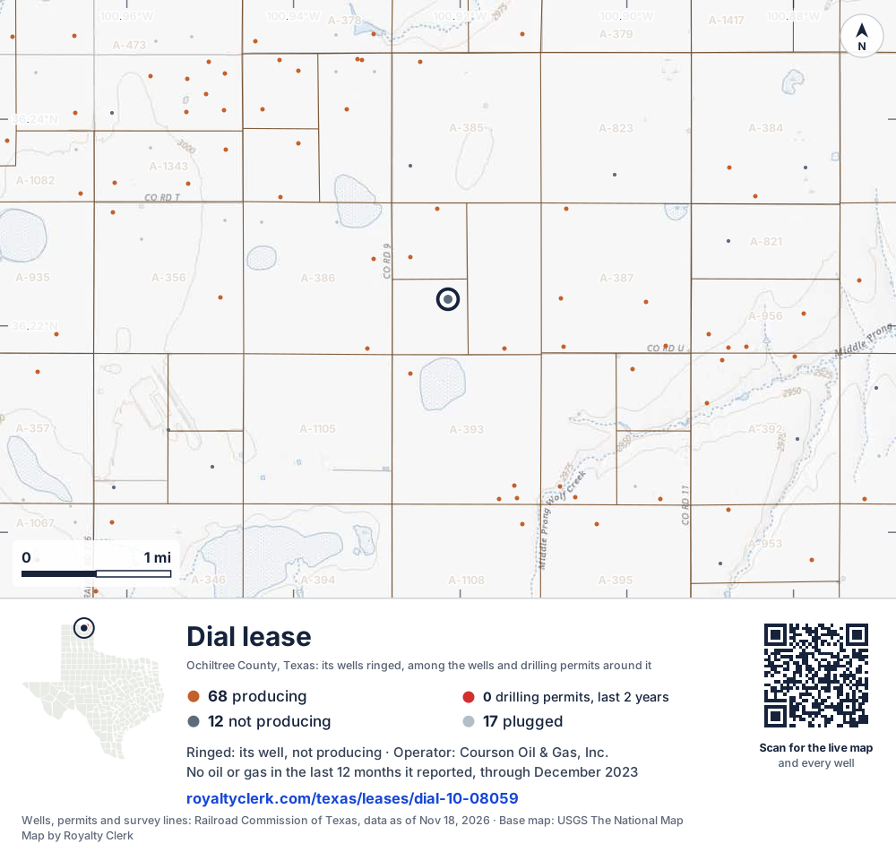
- This lease1Its well, ringed on the map: not producing
- Drilling locations0Permits issued in the last two years
- Producing wells68On a lease reporting production now
- Not producing12Shut in, inactive or no lease on record
- Plugged17The state's wellbore record says plugged
The ringed dot is this lease's well, where the Railroad Commission's map puts it. The other dots are wells and drilling permits of the last 24 months on the land around it; the counts are for everything in the picture, which is about 6 miles across. The thin brown lines are the original land surveys; where there is room, a survey carries its abstract number, the number deeds and division orders cite. Sources: Railroad Commission of Texas well layers, drilling permit files and survey lines, base map from USGS The National Map.
A one-page map of this lease to print, for a lawyer, a buyer or a probate file.
Use this map on your site
You may show this map on any site, unchanged. Keep the credit line and its link to Royalty Clerk under the map. The picture updates by itself as the state records new wells and permits.
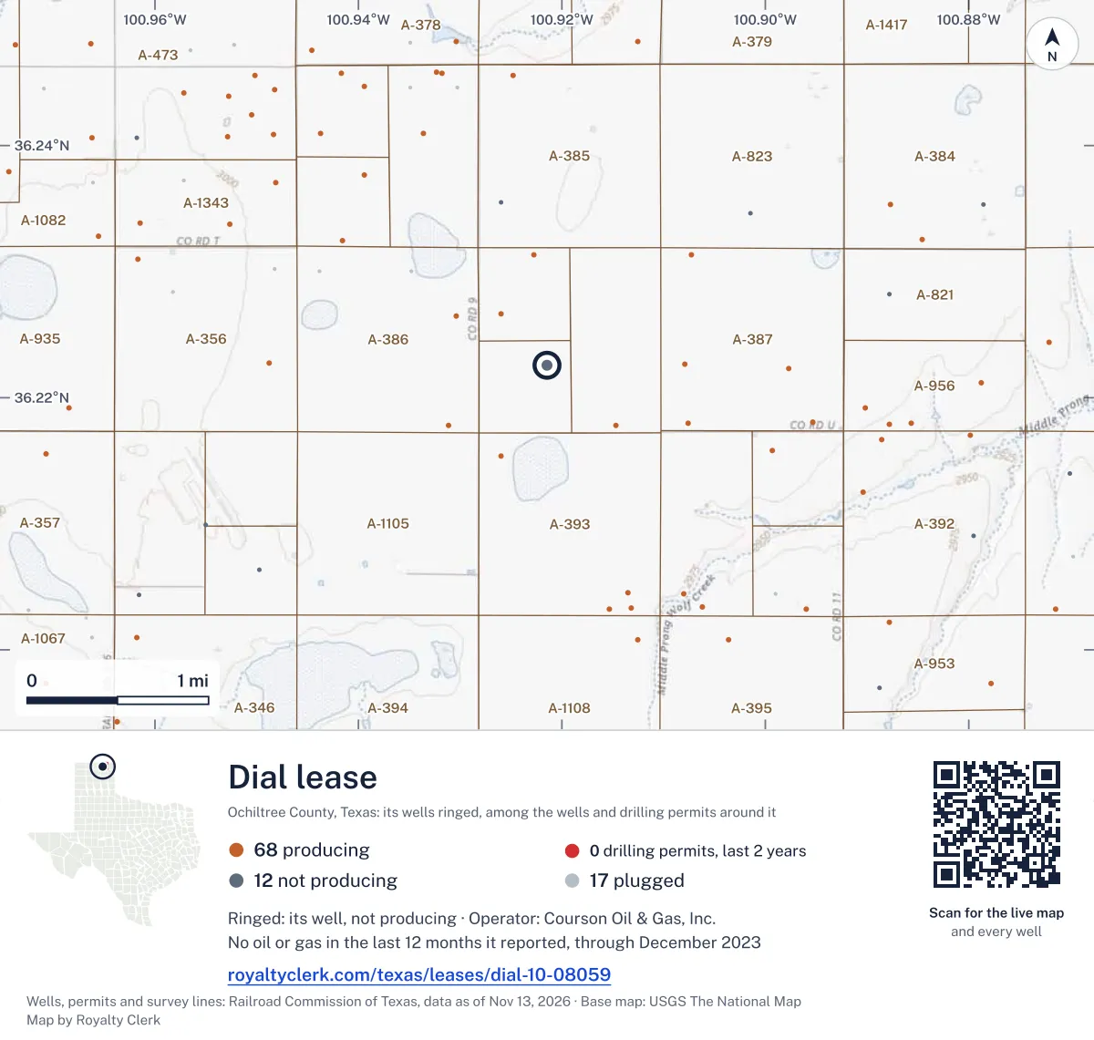
<a href="https://royaltyclerk.com/texas/leases/dial-10-08059"><img src="https://royaltyclerk.com/maps/lease-wells/dial-10-08059.svg" alt="Map of the Dial lease in Ochiltree County, Texas: its well ringed, among 97 wells and 0 recent drilling locations in a picture about 6 miles across." width="1000" height="951" loading="lazy" style="max-width:100%;height:auto;border:0"></a>
<p style="margin:4px 0 0;font-size:14px">Map: <a href="https://royaltyclerk.com/texas/leases/dial-10-08059">Wells on the Dial lease, Ochiltree County, Texas</a> by Royalty Clerk, from Railroad Commission of Texas records</p>
Other leases named Dial
- 10-294367, gas wellProducing22,660 mcflast 12 reported months
- 10-026461, gas wellProducing2,069 mcflast 12 reported monthsRun by Bce-Mach III LLC
- 10-026459, gas wellProducing1,296 mcflast 12 reported monthsRun by Bce-Mach III LLC
- 10-026460, gas wellProducing1,296 mcflast 12 reported monthsRun by Bce-Mach III LLC
- 10-00911, oil leaseShut in0 bbllast 12 reported monthsRun by Large Operating LLC
- 10-08059, oil leaseThis leaseNo report in 6+ months0 bbllast 12 reported months
Production by month
The 36 months up to its last report
- Oil (bars)
- Gas (line)
SourceTexas Railroad Commission Production Data Query, through Aug 2026.
Where the gas went
97% of the gas went to a transmission line in the last 12 months
- Transmission line (2)
- Lease fuel (1)
SourceTexas Railroad Commission Production Data Query, through Aug 2026.
Transmission line (2)
97% · 26,733 mcf
Lease fuel (1)
2.7% · 730 mcf
1 well on this lease
| API number | Well | Status | Completed |
|---|---|---|---|
| 42-357-31159 | Dial 1 | Not plugged | Jun 11, 1981 |
SourceTexas Railroad Commission production records and full wellbore file.
Other leases on these wells
The Railroad Commission files the same API numbers under one more lease too: a well keeps its number when it moves into a unit or is recompleted under another lease. A deed older than the unit may name one of them.
- Dial, Ochiltree County · 1 shared well
Buyers and gatherers
| Company | Product | Role | Share% | From | Until |
|---|---|---|---|---|---|
| Cp Energy, L.l.c. | Oil | Gathers | 100 | Feb 1, 2019 | – |
| Dcp Operating Company, LP | Casinghead gas | Buys | 100 | Apr 1, 2017 | – |
| Dcp Operating Company, LP | Casinghead gas | Gathers | 100 | Apr 1, 2017 | – |
| Jp Energy Products Supply, LLC | Oil | Gathers | 100 | Mar 1, 2014 | Feb 1, 2019 |
SourceRailroad Commission Form P-4 file, Oct 24, 2026 (source).
Estimate your royalty
36 months, newest first
| Month | Oil producedbbl | Oil soldbbl | Gas producedmcf | Gas soldmcf, codes 2+3 | Flaredmcf | WTI$/bbl | Henry Hub$/MMBtu |
|---|---|---|---|---|---|---|---|
| Dec 2023 | 0 | 0 | 0 | 0 | 0 | $71.90 | $2.52 |
| Nov 2023 | 0 | 0 | 0 | 0 | 0 | $77.69 | $2.71 |
| Oct 2023 | 0 | 44 | 0 | 0 | 0 | $85.64 | $2.98 |
| Sep 2023 | 0 | 0 | 0 | 0 | 0 | $89.43 | $2.64 |
| Aug 2023 | 0 | 0 | 0 | 0 | 0 | $81.39 | $2.58 |
| Jul 2023 | 0 | 0 | 0 | 0 | 0 | $76.07 | $2.55 |
| Jun 2023 | 0 | 0 | 0 | 0 | 0 | $70.25 | $2.18 |
| May 2023 | 0 | 0 | 0 | 0 | 0 | $71.58 | $2.15 |
| Apr 2023 | 0 | 0 | 0 | 0 | 0 | $79.45 | $2.16 |
| Mar 2023 | 0 | 0 | 0 | 0 | 0 | $73.28 | $2.31 |
| Feb 2023 | 0 | 0 | 0 | 0 | 0 | $76.83 | $2.38 |
| Jan 2023 | 0 | 0 | 0 | 0 | 0 | $78.12 | $3.27 |
| Dec 2022 | 0 | 0 | 2,057 | 1,995 | 0 | $76.44 | $5.53 |
| Nov 2022 | 0 | 0 | 2,243 | 2,183 | 0 | $84.37 | $5.45 |
| Oct 2022 | 0 | 0 | 2,307 | 2,245 | 0 | $87.55 | $5.66 |
| Sep 2022 | 0 | 0 | 2,250 | 2,190 | 0 | $84.26 | $7.88 |
| Aug 2022 | 0 | 0 | 2,137 | 2,075 | 0 | $93.67 | $8.81 |
| Jul 2022 | 0 | 0 | 2,350 | 2,288 | 0 | $101.62 | $7.28 |
| Jun 2022 | 0 | 0 | 2,301 | 2,241 | 0 | $114.84 | $7.70 |
| May 2022 | 0 | 0 | 2,390 | 2,328 | 0 | $109.55 | $8.14 |
| Apr 2022 | 0 | 0 | 2,334 | 2,274 | 0 | $101.78 | $6.60 |
| Mar 2022 | 0 | 0 | 2,460 | 2,398 | 0 | $108.50 | $4.90 |
| Feb 2022 | 0 | 0 | 2,235 | 2,179 | 0 | $91.64 | $4.69 |
| Jan 2022 | 8 | 0 | 2,399 | 2,337 | 0 | $83.22 | $4.38 |
| Dec 2021 | 0 | 0 | 2,665 | 2,603 | 0 | $71.71 | $3.76 |
| Nov 2021 | 0 | 192 | 2,687 | 2,627 | 0 | $79.15 | $5.05 |
| Oct 2021 | 0 | 0 | 2,962 | 2,900 | 0 | $81.48 | $5.51 |
| Sep 2021 | 0 | 0 | 3,083 | 3,023 | 0 | $71.65 | $5.16 |
| Aug 2021 | 0 | 0 | 3,689 | 3,631 | 0 | $67.73 | $4.07 |
| Jul 2021 | 0 | 0 | 17 | 13 | 0 | $72.49 | $3.84 |
| Jun 2021 | 0 | 0 | 1,837 | 1,809 | 0 | $71.38 | $3.26 |
| May 2021 | 0 | 0 | 2,454 | 2,402 | 0 | $65.17 | $2.91 |
| Apr 2021 | 0 | 0 | 2,535 | 2,475 | 0 | $61.72 | $2.66 |
| Mar 2021 | 0 | 0 | 2,877 | 2,815 | 0 | $62.33 | $2.62 |
| Feb 2021 | 0 | 0 | 2,565 | 2,509 | 0 | $59.04 | $5.35 |
| Jan 2021 | 0 | 0 | 3,037 | 2,975 | 0 | $52.00 | $2.71 |
SourceTexas Railroad Commission Production Data Query, through Aug 2026. Prices: EIA, through Oct 2026. Updated Oct 30, 2026.
How to check your stub against this lease Checks stopped on this lease? See the likely reasonsNearby
This lease belongs to
Courson Oil & Gas, Inc. in Ochiltree County
- WAMBLE
4,777 mcf
- PAUL
4,379 mcf
- MCLAIN -DH-
4,135 mcf
- GEORGE, GARY ESTATE
4,038 mcf
- PSHIGODA -O-
745 mcf
- LINA -BH-
3,610 mcf
- FIRST NATIONAL TRUST
2,925 mcf
- MCLAIN -DH-
3,280 mcf
- BOYER
2,748 mcf
- PATRICIA
4 mcf
Leases within 10 km
- ERICKSON
18 mcf · 0.6 km
- RIFENBURG 58
404 bbl · 0.8 km
- RICHARDSON
8,211 mcf · 0.9 km
- WHITE
6,247 mcf · 0.9 km
- RIFENBURG
929 bbl · 1 km
- WHITE 57
2,953 bbl · 1 km
- BUZZARD
2,576 mcf · 1.2 km
- BUZZARD 59
1,144 bbl · 1.4 km
- WHITE
0 mcf · 1.5 km
- STEPHENSON
1,733 mcf · 1.5 km
Drilling permits within 10 km
THURMAN 23 #1H
new drill · horizontal · King Operating Corporation · Ochiltree County · 7.4 km
Permit 0916686 · Jun 29, 2026
PRESCOTT - IRVIN #4354HM
new drill · horizontal · King Operating Corporation · Ochiltree County · 4.9 km
Permit 0912048 · Dec 9, 2025
FARNSWORTH UNIT #2003
recompletion · Capturepoint LLC · Ochiltree County · 8 km
Permit 0909725 · Oct 13, 2025
COURSON WERMSKE 89 A #C001CN
new drill · horizontal · Mewbourne Oil Company · Ochiltree County · 5.6 km
Permit 0905195 · Jan 17, 2025
COURSON SHIELDKNIGHT 101 #C001NC
new drill · horizontal · Mewbourne Oil Company · Ochiltree County · 9.2 km
Permit 0905125 · Jan 16, 2025