
Texas oil leaseRRC 06-12427Last oil or gas reported Sep 2024
Farrell, J. M.
One well on 80 acres in Gregg County. No oil or gas reported in its last 12 months on record, through July 2026. Reports are on file for all 12 months, with no oil and no gas. No report after July 2026 is on file; the State's newest month is August 2026.
- Last operator
- Elms Oil Company
- County
- Gregg
- On record since
- January 1993
- Newest report on file
- July 2026
- Unit on the newest permit
- 80 acres
Outline: the original land surveys this lease's wells sit in. The State publishes no lease outlines. RRC surveys, 2026-09-29.
No oil or gas reported in the 12 months through August 2026
Oil or gas was last reported for September 2024
Its whole life in the Railroad Commission's monthly reports, which start in January 1993; it was already producing then. Royalty owners and their heirs can still be on the county roll after the checks stop.
- 1993Already producing when the records start
- 2008The year it sold the most
- Elms Oil CompanyLast operator, from September 2025
- May 2018Last sale reported
- September 2024Last oil produced
- 22 monthsNo oil or gas reported, October 2024 to July 2026
barrels of oil sold since 1993.
thousand cubic feet of gas sold since 1993.
what it all sold for at each month's public prices, 100% of the lease.
SourceRailroad Commission production reports since January 1993 (oil and gas sold); EIA prices, through August 2026.
The story, from 403 monthly reports
On record since January 1993
March 1993: the first month the lease sold oil on record, 378 barrels.
February 1997: Basa Resources, Inc. took over.
October 2021 to July 2024: 34 months in a row with no oil and no gas reported.
September 2025: Elms Oil Company took over from Basa Resources, Inc..
July 2026 is the newest monthly production report on file.
SourceRailroad Commission production reports, January 1993 through August 2026. Not a forecast, not reserves.
Checks stopped on this lease?
Operator changed: Elms Oil Company took over from Basa Resources, Inc. in Sep 2025.
The current operator's P-5 registration is listed as delinquent (last P-5 filed Sep 16, 2025).
SourceRailroad Commission production, P-5 and P-4 records, data through August 2026.See why checks stop on this lease
404 months against 7 other recordsNew
Every month since January 1993, and what else happened that month
The lease is the line on top. Under it, on the same clock: the weather, the State, the price, the wells next door, who ran the lease, who bought from it and the rest of the field. Move across it.
Oil averaged $45.18 a barrel · Basa Resources, Inc.
- Nothing else on record this month.
Move the pointer or drag across the chart. The numbered buttons jump to each drop.
Monthly oil sold from this lease since January 1993, with eight record tracks beneath it. Use the left and right arrow keys to move month by month.. 404 months from January 1993 to August 2026. The most in one month: 551 barrels, March 1994. The newest month: 0 barrels. 175 months with nothing reported. Moments marked: 1, Oct 1993; 2, Jul 1994; 3, Jun 1996; 4, Nov 1997; 5, Oct 1998; 6, Mar 1999; 7, Jan 2003; 8, Sep 2007.
SourcesProduction, cut-offs, operators and buyers: Railroad Commission of Texas. Weather: NOAA. Prices: U.S. Energy Information Administration. Fracs: FracFocus. A record in the same month is not proof of a cause. Through August 2026. The newest report on file for this lease is for July 2026; no report after it is on file.
Royalty Watch tells you the month a drop starts, with the records from that month.Watch this lease
403 months, one line eachNew
No production was reported from October 2024 through July 2026
A gap is a month with no oil and no gas reported. Many leases end after 60 to 90 days without production unless the lease says otherwise.
months in a row with nothing reported, from October 2024 through July 2026. Reports are on file for all 22 months, with no oil and no gas.
barrels of oil on the newest report on file with oil or gas, for September 2024. The 22 reports on file after it, the newest for July 2026, show no oil and no gas. No report after July 2026 is on file; the State's newest month is August 2026.
of 403 months with oil or gas reported since January 1993.
A shut-in payment or work on the wells can keep a lease alive through a gap. Your own lease paper decides.
SourceRailroad Commission production reports, January 1993 through July 2026. The months after May 2026 are counted from this lease's own reports filed since. The newest months, after July 2026, are left out of the count because reports arrive late.
Royalty Watch tells you when a silent month starts, and drafts the letter asking whether the lease is still in force.Watch this lease
34 years of state records, 1993 to 2026
Sold since January 1993
$2.49million
Only filed sales with a published price are included. Some sales figures or prices are unavailable.
- Oil sold
- 45,881barrels
- Gas sold
- 111,048thousand cubic feet
| Year | Oil, dollars | Gas, dollars | Total |
|---|---|---|---|
| 1993 | $35,300 | $12,700 | $48,000 |
| 1994 | $49,800 | $13,600 | $63,400 |
| 1995 | $52,000 | $12,200 | $64,200 |
| 1996 | $48,700 | $8,370 | $57,000 |
| 1997 | $36,600 | $3,690 in priced filings | $40,300 in priced filings |
| 1998 | $35,900 | $2,140 | $38,000 |
| 1999 | $50,800 | $11,000 | $61,800 |
| 2000 | $79,000 | $24,400 | $103,000 |
| 2001 | $72,100 | $17,500 | $89,500 |
| 2002 | $59,500 | $16,900 in priced filings | $76,400 in priced filings |
| 2003 | $63,100 | $28,000 | $91,100 |
| 2004 | $87,100 | $24,400 | $111,000 |
| 2005 | $118,000 | $39,100 | $158,000 |
| 2006 | $151,000 | $30,400 | $181,000 |
| 2007 | $134,000 | $26,800 | $161,000 |
| 2008 | $228,000 | $53,900 | $282,000 |
| 2009 | $111,000 | $32,500 | $144,000 |
| 2010 | $126,000 | $28,200 | $154,000 |
| 2011 | $143,000 | $23,500 | $167,000 |
| 2012 | $132,000 | $17,700 | $150,000 |
| 2013 | $99,300 | $20,900 | $120,000 |
| 2014 | $65,700 | $13,100 in priced filings | $78,800 in priced filings |
| 2015 | $22,700 | $1,190 in priced filings | $23,800 in priced filings |
| 2016 | $7,530 | Unavailable | $7,530 in priced filings |
| 2017 | $18,500 | Unavailable | $18,500 in priced filings |
| 2018 | $1,050 | Unavailable | $1,050 in priced filings |
| 2019 | $0 | Unavailable | Unavailable |
| 2020 | $0 | $0 | $0 |
| 2021 | $0 | $0 | $0 |
| 2022 | $0 | $0 | $0 |
| 2023 | $0 | $0 | $0 |
| 2024 | $0 | $0 | $0 |
| 2025 | $0 | $0 | $0 |
| 2026, 2026 so far | $0 | $0 | $0 |
Did a relative own a share of this lease?
SourcesRailroad Commission Production Data Query, every monthly report since January 1993. EIA monthly WTI and Henry Hub prices (before 1997, EIA's Texas wellhead gas price). 2026 is part of a year, drawn lighter. Not a forecast, not reserves.
Who has run this lease
The operator changed four times, most recently in September 2025
The company named on each monthly report to the State. The operator is not always the company that pays.
- Elms Oil CompanySeptember 2025 to August 2026
- Basa Resources, Inc.February 1997 to August 2025
- Operator number 137330September 1996 to January 1997
- Operator number 801642June 1994 to August 1996
- Machin & Associates, Inc.January 1993 to May 1994
SourcesRailroad Commission production reports, the operator on each month’s report, January 1993 through August 2026.
The newest well, seen from the side
No well on the way. Well 1 was completed in September 1988.
- Permit filedNot on file
- Drilling startedNot on file
- FrackedNot on file
- Completion filedSeptember 2, 1988
- First production on the leaseNot on file
- First checkNot on file
SourcesRailroad Commission drilling permits and well records, and the FracFocus registry. Lease record built November 17, 2026.
Royalty Watch follows new well permits and completions on this lease.Watch this lease
About 6 miles across
Wells on this lease and around it
For a lawyer, a buyer or a probate file. Wells and permits within about 2 miles. Railroad Commission of Texas, FracFocus and USGS imagery.
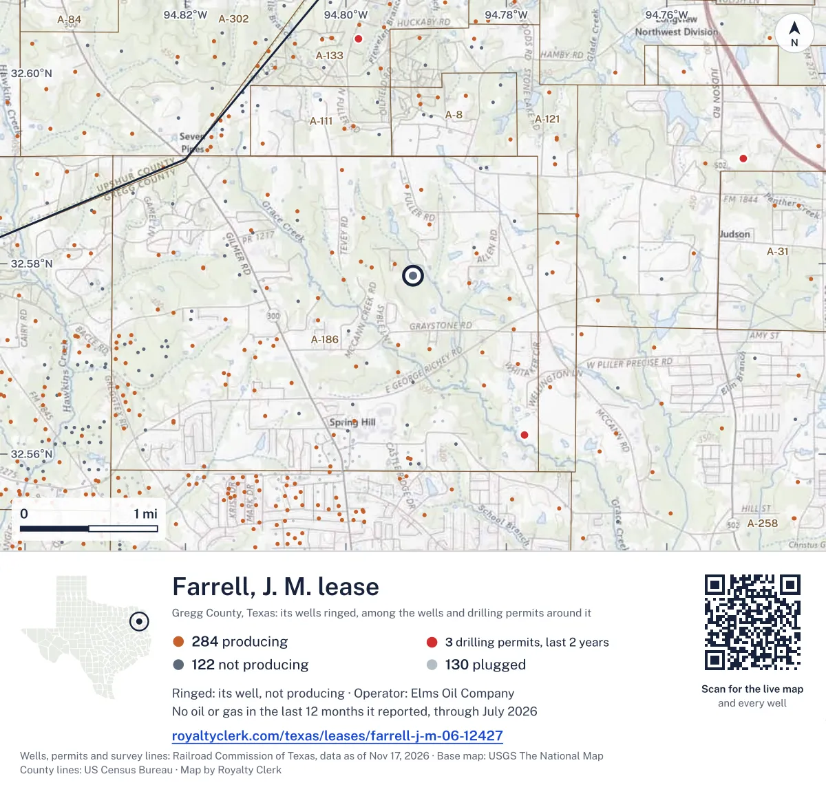
From the State's well records
One well on this lease
| Well | API number | Completed | Depthfeet | Today |
|---|---|---|---|---|
| 1 | 42-183-30732 | September 1988 | 7,901 | Shut in |
SourceRailroad Commission wellbore and completion records.
What the drilling permits say
80acres on the newest permit
- 80 acres, on the 1988 permits
Oil · last sale month, May 2018 New
Four prices for the same oil
Last sale May 2018. WTI $69.98 in May 2018, the last sale month.
Texas Comptroller
Tax approval on record
SB 290, approved March 11, 1999.
EIA record dated October 1, 2026Estimate your royalty
Type the decimal from your division order
The starting decimal is an example. Nothing you type here leaves this page.
$0a month
At these prices the whole lease’s reported sales were about $0 over 12 reported months. Your estimated share is $0 before taxes and deductions.
Monthly owner volumes and values
| Month | Oil (bbl) | Oil value | Gas (mcf) | Gas value | Total |
|---|---|---|---|---|---|
| July 2026 | 0 | $0.00 | 0 | $0.00 | $0.00 |
| June 2026 | 0 | $0.00 | 0 | $0.00 | $0.00 |
| May 2026 | 0 | $0.00 | 0 | $0.00 | $0.00 |
| April 2026 | 0 | $0.00 | 0 | $0.00 | $0.00 |
| March 2026 | 0 | $0.00 | 0 | $0.00 | $0.00 |
| February 2026 | 0 | $0.00 | 0 | $0.00 | $0.00 |
| January 2026 | 0 | $0.00 | 0 | $0.00 | $0.00 |
| December 2025 | 0 | $0.00 | 0 | $0.00 | $0.00 |
| November 2025 | 0 | $0.00 | 0 | $0.00 | $0.00 |
| October 2025 | 0 | $0.00 | 0 | $0.00 | $0.00 |
| September 2025 | 0 | $0.00 | 0 | $0.00 | $0.00 |
| August 2025 | 0 | $0.00 | 0 | $0.00 | $0.00 |
SourcesRailroad Commission monthly production, EIA WTI, SEC filings and Texas Comptroller records.
Watch Plus sets public prices beside the price on your statement.See Watch Plus
Who takes the oil and gasNew
No buyer shares an owner with the operator
The State lists who gathers and who buys from each lease. Company filings list who owns whom. Here they are on one drawing.
No shared owner, officer or address on record between the oil buyers and the operator.
Also on the P-4: PLAINS MARKETING, L.P. gathers 50%.
Earlier buyers and gatherers, back to 1993
| Company | Product | Role | From | Until |
|---|---|---|---|---|
| PLAINS MARKETING, L.P. | Oil | Gathers | Jul 2023 | Sep 2026 |
| ENERGY TRANS CRUDE MARKETING LLC | Oil | Gathers | Jul 2021 | Jul 2023 |
| PLAINS MARKETING, L.P. | Oil | Gathers | Jul 2020 | Jul 2021 |
| SUNOCO PTNRS. MKTG.&TERMINALS LP | Oil | Gathers | Apr 2002 | Jul 2020 |
| BP AMERICA PRODUCTION COMPANY | Gas | Gathers and buys | Jan 2002 | Jul 2020 |
Who buys my oilOil price check
SourcesBuyers and gatherers: Railroad Commission Form P-4 records, as of October 24, 2026. Ownership: U.S. Securities and Exchange Commission filings.
Royalty Watch tells you the day the buyer of your oil or gas changes.Watch this lease
Seen from space, 2025New
No satellite heat at this pad in 2025
Weather satellites pass over Texas every night and record heat on the ground. Drag the photo from day to night. Beside it, each night of 2025 next to what the operator reported burning.
A lit dot is a night a satellite recorded heat within 500 m of a well on this lease. The red bar is gas reported vented or flared that month.
nights with heat recorded at this pad, 2025.
months in which flaring was reported.
months with heat seen and no flaring reported.
SourcesHeat: NOAA-20, NOAA-21 and Suomi NPP (to November 2, 2026) VIIRS active fire product, night readings (NOAA open data); the readings at this pad from NOAA-20, NOAA-21 and Suomi NPP, through November 16, 2026. Reported flaring and gas use: Railroad Commission production reports. Cloud hides heat, so the count of nights is a floor. The satellite records heat. It does not say what burned.
Watch Plus checks whether you were paid on gas in the months heat was seen.See Watch Plus
The county appraisal roll
No public roll figures
County mineral roll
No public roll figures
There are no publishable figures for this lease from the 2026 county mineral roll.
Royalty Clerk has mineral rolls for 146 Texas counties.
Source County appraisal district mineral rolls.
From the state record
Ask a question about Farrell, J. M.
The available public records have no additional lease-specific answers as of November 19, 2026.
Every monthly report the State holds
404 months, newest first
| Month | Oil soldbarrels | Gas soldthousand cubic feet | Flared or ventedthousand cubic feet | Sold forat public prices | Operator |
|---|---|---|---|---|---|
| AugustAug 2026 | No report on file | – | |||
| JulyJul 2026 | No oil or gas reported | Elms Oil Company | |||
| JuneJun 2026 | No oil or gas reported | Elms Oil Company | |||
| MayMay 2026 | No oil or gas reported | Elms Oil Company | |||
| AprilApr 2026 | No oil or gas reported | Elms Oil Company | |||
| MarchMar 2026 | No oil or gas reported | Elms Oil Company | |||
| FebruaryFeb 2026 | No oil or gas reported | Elms Oil Company | |||
| JanuaryJan 2026 | No oil or gas reported | Elms Oil Company | |||
| DecemberDec 2025 | No oil or gas reported | Elms Oil Company | |||
| NovemberNov 2025 | No oil or gas reported | Elms Oil Company | |||
| OctoberOct 2025 | No oil or gas reported | Elms Oil Company | |||
| SeptemberSep 2025 | No oil or gas reported | Elms Oil Company | |||
| AugustAug 2025 | No oil or gas reported | Basa Resources, Inc. | |||
| JulyJul 2025 | No oil or gas reported | Basa Resources, Inc. | |||
| JuneJun 2025 | No oil or gas reported | Basa Resources, Inc. | |||
| MayMay 2025 | No oil or gas reported | Basa Resources, Inc. | |||
| AprilApr 2025 | No oil or gas reported | Basa Resources, Inc. | |||
| MarchMar 2025 | No oil or gas reported | Basa Resources, Inc. | |||
SourcesTexas Railroad Commission Production Data Query, through August 2026. Prices: EIA.
Likely owed Jan 2025
A whole month was never paid
The state shows 28,175 bbl of oil sold from this lease in January 2025, so your share is 27.51 bbl. No statement covers January 2025. That is the month the operator changed from Endeavor Energy Resources to Diamondback.
Ask Diamondback owner relations: is January 2025 being held in suspense after the change of operator?
$2,277oil + gas
A sample finding, from our example check. The full example found $3,328 likely owed.
Around this lease
Nearby
Elms Oil Company in Gregg County
- Pine Hill Church224 bbl last 12 months
- Pine Hill School185 bbl last 12 months
- Jones-B146 bbl last 12 months
- Fuller, J. J. "B"120 bbl last 12 months
- Freeman, J.101 bbl last 12 months
- Colburn94 bbl last 12 months
- McKinley, J. C.84 bbl last 12 months
- Harrison -B-83 bbl last 12 months
- Tooke, A.61 bbl last 12 months
- White, R. B.51 bbl last 12 months
Johnson-Tekell (Travis Peak Oil) field
- Castleberry, Jack2,250 bbl last 12 months
Leases within 10 km
- McMurreyno production in the last 12 months · 0.1 km
- Mattox, G. C.1,350 bbl last 12 months · 0.2 km
- Mattox229 bbl last 12 months · 0.5 km
- McMurrey 'A'990 bbl last 12 months · 0.6 km
- McMurrey753 bbl last 12 months · 0.7 km
- McMurreyno production in the last 12 months · 0.8 km
- Bruton, Trudie114 bbl last 12 months · 0.8 km
- Clemens, C. C. -B-797 bbl last 12 months · 0.8 km
- Alexander, J. H.1,863 bbl last 12 months · 0.8 km
- McMurrey58,201 mcf last 12 months · 0.9 km
Drilling permits within 10 km
- LONGVIEW NORTH - HENDERSON (AW) #1Hnew drill · horizontal · Buffco Production Inc. · Nov 2, 2026 · 7.3 km
- CULPEPPER #7recompletion · Neches Exploration, L.L.C. · Oct 28, 2026 · 2.3 km
- HAMBY 4 #1recompletion · Faulconer Energy, LLC · Aug 3, 2026 · 5.4 km
- SPEAR NO. 1 #1recompletion · Faulconer Energy, LLC · Apr 17, 2026 · 4.1 km
- EVANS, M. W. #2recompletion · Mud Creek Operating, LLC · Mar 18, 2026 · 5.4 km
Where it sits
This county
Where this page comes from
- Railroad Commission of Texas production, Form P-4, permits, wells
- Texas Comptroller tax approvals, lease values
- U.S. Energy Information Administration prices
- FracFocus frac dates
- NOAA storms and cold
- NOAA-20, NOAA-21 and Suomi NPP (to November 2, 2026) VIIRS active fire product, night readings (NOAA open data) night heat
- U.S. Geological Survey photos