
Texas oil leaseRRC 01-17725Producing
Lion Unit
One well on 442 acres in Atascosa County. The lease produced 2,074 barrels of oil in the last 12 months, through August 2026.
- Operator
- EOG Resources, Inc.
- County
- Atascosa
- On record since
- April 2014
- Newest report on file
- August 2026
- Unit on the newest permit
- 442 acres
Outline: the original land surveys this lease's wells sit in. The State publishes no lease outlines. RRC surveys, 2026-09-29.
The story, from 149 monthly reports
2014 to 2026: it sold the most in 2014
April 2014: the first month the lease sold oil on record, 7 barrels.
2014: the year the lease sold the most, $4.98 million of oil and gas at public prices.
June 2020 to July 2020: two months in a row with no oil and no gas reported.
August 2026 is the newest monthly production report on file.
SourceRailroad Commission production reports, April 2014 through August 2026. Not a forecast, not reserves.
149 months against 7 other recordsNew
Every month since April 2014, and what else happened that month
The lease is the line on top. Under it, on the same clock: the weather, the State, the price, the wells next door, who ran the lease, who bought from it and the rest of the field. Move across it.
Oil averaged $60.06 a barrel · EOG Resources, Inc.
- Nothing else on record this month.
Move the pointer or drag across the chart. The numbered buttons jump to each drop.
Monthly oil sold from this lease since April 2014, with eight record tracks beneath it. Use the left and right arrow keys to move month by month.. 149 months from April 2014 to August 2026. The most in one month: 9,541 barrels, June 2014. The newest month: 307 barrels. 10 months with nothing reported. Moments marked: 1, Feb 2015; 2, Nov 2017; 3, Dec 2017; 4, May 2020; 5, Oct 2020; 6, Nov 2020; 7, Sep 2025; 8, Nov 2025.
SourcesProduction, cut-offs, operators and buyers: Railroad Commission of Texas. Weather: NOAA. Prices: U.S. Energy Information Administration. Fracs: FracFocus. A record in the same month is not proof of a cause. Through August 2026.
Royalty Watch tells you the month a drop starts, with the records from that month.Watch this lease
146 months, one line eachNew
Two months of silence in 2020
A gap is a month with no oil and no gas reported. Many leases end after 60 to 90 days without production unless the lease says otherwise.
months in a row with nothing reported, June to July 2020. Reports are on file for all 2 months, with no oil and no gas. The only silence on record here.
barrels of oil and 209 thousand cubic feet of gas on the newest report on file with oil or gas, for August 2026, the State's newest month.
of 146 months with oil or gas reported since April 2014.
barrels of oil a day on average from September 2025 through August 2026, counting a month with no report on file as zero.
A shut-in payment or work on the wells can keep a lease alive through a gap. Your own lease paper decides.
SourceRailroad Commission production reports, April 2014 through May 2026. The newest months, after May 2026, are left out of the count because reports arrive late.
Royalty Watch tells you when a silent month starts, and drafts the letter asking whether the lease is still in force.Watch this lease
13 years of state records, 2014 to 2026
Sold since April 2014
$10.4million
Sales at public prices before tax and deductions. Multiply by your decimal interest to estimate your share.
- Oil sold
- 143,120barrels
- Gas sold
- 146,416thousand cubic feet
- Best year
- 2014$4.98 million sold
| Year | Oil, dollars | Gas, dollars | Total |
|---|---|---|---|
| 2014 | $4.86 million | $121,000 | $4.98 million, sold the most |
| 2015 | $1.57 million | $94,300 | $1.66 million |
| 2016 | $584,000 | $18,700 | $602,000 |
| 2017 | $512,000 | $9,260 | $521,000 |
| 2018 | $572,000 | $40,900 | $613,000 |
| 2019 | $310,000 | $25,000 | $335,000 |
| 2020 | $195,000 | $24,300 | $219,000 |
| 2021 | $251,000 | $46,900 | $298,000 |
| 2022 | $301,000 | $49,700 | $351,000 |
| 2023 | $235,000 | $21,600 | $257,000 |
| 2024 | $232,000 | $12,400 | $245,000 |
| 2025 | $145,000 | $9,390 | $155,000 |
| 2026, 2026 so far | $136,000 | $4,940 | $141,000 |
Did a relative own a share of this lease?
SourcesRailroad Commission Production Data Query, every monthly report since April 2014. EIA monthly WTI and Henry Hub prices. 2026 is part of a year, drawn lighter. Not a forecast, not reserves.
The newest well, seen from the side
No well on the way. Well 1H was completed in May 2014.
- Permit filedNot on file
- Drilling startedNot on file
- FrackedNot on file
- Completion filedMay 18, 2014
- First production on the leaseNot on file
- First checkNot on file
SourcesRailroad Commission drilling permits and well records, and the FracFocus registry. Lease record built November 17, 2026.
Royalty Watch follows new well permits and completions on this lease.Watch this lease
About 6 miles across
Wells on this lease and around it
For a lawyer, a buyer or a probate file. Wells and permits within about 2 miles. Railroad Commission of Texas, FracFocus and USGS imagery.
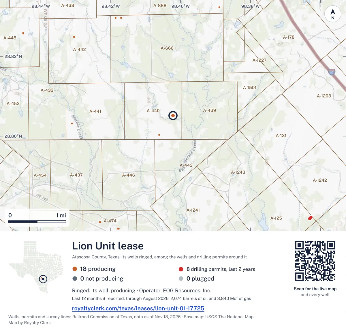
From the State's well records
One well on this lease
| Well | API number | Completed | Sidewaysfeet | Depthfeet | Today |
|---|---|---|---|---|---|
| 1H | 42-013-34932 | May 2014 | 5,514 | 8,898 | Active |
SourceRailroad Commission wellbore and completion records.
What the drilling permits say
442acres on the newest permit
- 442 acres, on the 2014 permits
Oil, August 2026, dollars per barrel New
Four prices for the same oil
What the market paid, what the operator told its investors, what it told the tax office for this lease, and the one only you hold.
The State approved a lower tax for this lease
- Kind
- Low Producing Leases
- Wells
- The whole lease
- Runs
- August 2020 to no end date on file
- Rate
- Not given in the file
Look at the tax line on your statement for this lease. The record says which rate applies.
Estimate your royalty
Type the decimal from your division order
The starting decimal is an example. Nothing you type here leaves this page.
$59a month
At these prices the whole lease’s reported sales were about $182,000 over 12 reported months. Your estimated share is $712 before taxes and deductions.
Monthly owner volumes and values
| Month | Oil (bbl) | Oil value | Gas (mcf) | Gas value | Total |
|---|---|---|---|---|---|
| August 2026 | 1.1992 | $100.61 | 0.8164 | $2.27 | $102.88 |
| July 2026 | 0.7344 | $59.09 | 0.4766 | $1.38 | $60.47 |
| June 2026 | 1.3203 | $111.98 | 0.4375 | $1.38 | $113.35 |
| May 2026 | 0.707 | $72.21 | 0.457 | $1.34 | $73.55 |
| April 2026 | 0.7344 | $73.67 | 0.6992 | $1.94 | $75.61 |
| March 2026 | 0.7383 | $67.46 | 1.0117 | $3.08 | $70.54 |
| February 2026 | 0.7305 | $47.12 | 0.082 | $0.30 | $47.42 |
| January 2026 | 0 | $0.00 | 0.9883 | $7.63 | $7.63 |
| December 2025 | 2.0078 | $116.39 | 1.5391 | $6.56 | $122.95 |
| November 2025 | 0 | $0.00 | 0.1875 | $0.71 | $0.71 |
| October 2025 | 0 | $0.00 | 0 | $0.00 | $0.00 |
| September 2025 | 0.5625 | $35.98 | 0.2031 | $0.60 | $36.58 |
SourcesMarket: U.S. Energy Information Administration (WTI Cushing for oil; Henry Hub for gas, taken per thousand cubic feet). Investors: EOG Resources, Inc., Form 10-Q, Q3 2026, company-wide. Tax office and tax approval: Texas Comptroller. The third price shows once the Comptroller's records for this lease have arrived. As of October 1, 2026.
Watch Plus sets these prices beside the price on each of your statements, every month.See Watch Plus
Who takes the oil and gasNew
The oil gatherer and the operator share an officer
The State lists who gathers and who buys from each lease. Company filings list who owns whom. Here they are on one drawing.
Also on the P-4: EOG RESOURCES MARKETING LLC gathers 10%.
No shared owner, officer or address on record between the gas buyers and the operator.
Selling to a related company is common and legal. It is also the first thing an auditor looks at, because the price between the two is set inside one company.
Earlier buyers and gatherers, back to 1993
| Company | Product | Role | From | Until |
|---|---|---|---|---|
| WILLIAMS MLP OPERATING LLC | Gas | Gathers | May 2019 | Jan 2021 |
| EOG RESOURCES MARKETING LLC | Oil | Gathers | Apr 2015 | Jan 2021 |
| EOG RESOURCES, INC. | Gas | Gathers | May 2014 | May 2019 |
Who buys my oilOil price check
SourcesBuyers and gatherers: Railroad Commission Form P-4 records, as of October 24, 2026. Ownership: U.S. Securities and Exchange Commission filings.
Royalty Watch tells you the day the buyer of your oil or gas changes.Watch this lease
Seen from space, 2025New
No satellite heat at this pad in 2025
Weather satellites pass over Texas every night and record heat on the ground. Drag the photo from day to night. Beside it, each night of 2025 next to what the operator reported burning.
A lit dot is a night a satellite recorded heat within 500 m of a well on this lease. The red bar is gas reported vented or flared that month.
nights with heat recorded at this pad, 2025.
months in which flaring was reported, 155 thousand cubic feet in all.
months with heat seen and no flaring reported.
Where the gas went in 2025, as the operator reported it
SourcesHeat: NOAA-20, NOAA-21 and Suomi NPP (to November 2, 2026) VIIRS active fire product, night readings (NOAA open data); the readings at this pad from NOAA-20, NOAA-21 and Suomi NPP, through November 16, 2026. Reported flaring and gas use: Railroad Commission production reports. Cloud hides heat, so the count of nights is a floor. The satellite records heat. It does not say what burned.
Watch Plus checks whether you were paid on gas in the months heat was seen.See Watch Plus
Where the gas went, month by month
Since May 2026 the lease's gas goes to lease fuel instead of a processing plant
Where gas goes decides how it is paid: processed gas can carry plant products and processing fees, gas sold straight to a pipeline usually does not.
- Lease fuel (1)48% · 2,021 mcf
- Processing plant (3)48% · 2,018 mcf
- Flared (4)3.8% · 159 mcf
3.8% of the gas was flared in the last 12 months. 24 months above 3%, the most 8.9% in April 2024.
SourcesRailroad Commission production reports, gas disposition by code, September 2023 to August 2026.
Atascosa County Appraisal District, 2026 mineral roll
11 royalty accounts on the county roll
- Owners
- 21
- Accounts
- 21
- Appraised in all
- $54,790
Is one of these yours?
Each square is one account
- Royalty 11
- Overriding royalty 9
- Working interest 1
SourceAtascosa County Appraisal District, 2026 mineral roll (source), read October 7, 2026. Accounts matched to this lease by RRC number or lease name.
From the state record
What owners ask about Lion Unit
- 01When is the check for August 2026 due?
- Aug 31sale month endsOct 30oil dueNov 29gas due
- August 2026 is the newest month the state has posted for this lease. Texas law gives the payor until 60 days after the end of the sale month for oil and 90 for gas: the oil by Oct 30, 2026 and the gas by Nov 29, 2026, unless the lease sets another time.
- Source: Railroad Commission production reports; Texas Natural Resources Code §91.402.
- See your next three checks
- 02Which Texas production tax rate applies?
- Gas7.50%Oil4.60%
- The Texas Comptroller lists low producing leases for this lease, from Aug 1, 2020. Its file does not give the rate, so we compare your stub with the full 4.6%. That is for August 2026.
- Source: Texas Comptroller, approved severance tax exemptions.
- Check the tax on your stub
- 03Who buys the oil and gas?
- OILShell Trading (Us) Company90%GASEog Resources, Inc.100%
- Oil: Shell Trading (Us) Company and Eog Resources Marketing LLC gather it. Gas from oil wells: Eog Resources, Inc. buys and gathers it. The buyer's price is what a royalty check is figured on.
- Source: Railroad Commission Form P-4, gatherers and purchasers.
- See every buyer and past buyers
- 04How many 1099s should an owner expect for 2025?
- 1January to December 2025: one operator of record in all 12 months
- One company, EOG Resources, Inc., filed this lease's reports behind every 2025 check, so most owners get one form. The operator is not always the company that pays, so go by the name on the stubs.
- Source: Railroad Commission production reports, operator of record by month.
- Check your 1099 against it
Every monthly report the State holds
149 months, newest first
| Month | Oil soldbarrels | Gas soldthousand cubic feet | Flared or ventedthousand cubic feet | Sold forat public prices |
|---|---|---|---|---|
| AugustAug 2026 | 307 | 209 | 16 · 7.66% | $26,300 |
| JulyJul 2026 | 188 | 122 | 19 · 15.6% | $15,500 |
| JuneJun 2026 | 338 | 112 | 14 · 12.5% | $29,000 |
| MayMay 2026 | 181 | 117 | 12 · 10.3% | $18,800 |
| AprilApr 2026 | 188 | 179 | 18 · 10.1% | $19,400 |
| MarchMar 2026 | 189 | 259 | 22 · 8.49% | $18,100 |
| FebruaryFeb 2026 | 187 | 21 | 1 · 4.76% | $12,100 |
| JanuaryJan 2026 | 0 | 253 | 10 · 3.95% | $1,950 |
| DecemberDec 2025 | 514 | 394 | 30 · 7.61% | $31,500 |
| NovemberNov 2025 | 0 | 48 | 1 | $182 |
| OctoberOct 2025 | No oil or gas reported | |||
| SeptemberSep 2025 | 144 | 52 | 4 · 7.69% | $9,360 |
| AugustAug 2025 | 172 | 252 | 12 · 4.76% | $11,900 |
| JulyJul 2025 | 167 | 109 | 14 · 12.8% | $11,800 |
| JuneJun 2025 | 360 | 154 | 18 · 11.7% | $25,000 |
| MayMay 2025 | 172 | 194 | 16 · 8.25% | $11,300 |
| AprilApr 2025 | 159 | 203 | 13 · 6.40% | $10,800 |
| MarchMar 2025 | 173 | 331 | 14 · 4.23% | $13,200 |
SourcesTexas Railroad Commission Production Data Query, through August 2026. Prices: EIA.
Likely owed Jan 2025
A whole month was never paid
The state shows 28,175 bbl of oil sold from this lease in January 2025, so your share is 27.51 bbl. No statement covers January 2025. That is the month the operator changed from Endeavor Energy Resources to Diamondback.
Ask Diamondback owner relations: is January 2025 being held in suspense after the change of operator?
$2,277oil + gas
A sample finding, from our example check. The full example found $3,328 likely owed.
Around this lease
Nearby
EOG Resources, Inc. in Atascosa County
- DVR 'D'2,418 bbl last 12 months
- Dharma Unit2,176 bbl last 12 months
- Lucas 'C'2,196 bbl last 12 months
- H.e. Unit2,170 bbl last 12 months
- Bufflehead Unit2,103 bbl last 12 months
- Stone Unit2,100 bbl last 12 months
- Canvasback Unit2,096 bbl last 12 months
- Eland Unit2,088 bbl last 12 months
- Thompson C Unit2,066 bbl last 12 months
- Redhead Unit1,946 bbl last 12 months
Eagleville (Eagle Ford-1) field
- Roxana Unit2,160 bbl last 12 months
- Hixon-Larson 'A' Unit8,531 mcf last 12 months
- GW Deep Gas Unit 16,196 mcf last 12 months
- Lessor B Unit2,015 bbl last 12 months
- Swaim Unit I MCM2,039 bbl last 12 months
- Lucas 'C'2,196 bbl last 12 months
- Hixon-Trout B Unit9,799 mcf last 12 months
- Ramsey-Larson 'B' Unit5,827 mcf last 12 months
- H.e. Unit2,170 bbl last 12 months
- Clscm, LTD4,041 mcf last 12 months
Leases within 10 km
- Springbok Unit3,282 bbl last 12 months · 0.7 km
- Blesbok Unit1,732 bbl last 12 months · 2.8 km
- Hyena20,232 bbl last 12 months · 3.1 km
- East Hospital427,030 bbl last 12 months · 3.5 km
- Rhino Unit2,541 bbl last 12 months · 3.5 km
- Hippo Unit2,649 bbl last 12 months · 3.5 km
- Poth A29,065 bbl last 12 months · 3.6 km
- Eland Unit2,088 bbl last 12 months · 4.7 km
- Scheske5,591 bbl last 12 months · 4.8 km
- Tibetan Red Unit3,426 bbl last 12 months · 4.8 km
Drilling permits within 10 km
- WEST LAKE #3Hnew drill · horizontal · EOG Resources, Inc. · Jul 31, 2026 · 4.6 km
- WEST LAKE #4Hnew drill · horizontal · EOG Resources, Inc. · Jul 31, 2026 · 4.6 km
- WEST LAKE #1Hnew drill · horizontal · EOG Resources, Inc. · Jul 31, 2026 · 4.6 km
- WEST LAKE #2Hnew drill · horizontal · EOG Resources, Inc. · Jul 31, 2026 · 4.6 km
- WEST LAKE #5Hnew drill · horizontal · EOG Resources, Inc. · Jul 31, 2026 · 4.6 km
Where it sits
This county
Where this page comes from
- Railroad Commission of Texas production, Form P-4, permits, wells
- Texas Comptroller tax approvals, lease values
- U.S. Energy Information Administration prices
- SEC EDGAR company filings
- FracFocus frac dates
- NOAA storms and cold
- NOAA-20, NOAA-21 and Suomi NPP (to November 2, 2026) VIIRS active fire product, night readings (NOAA open data) night heat
- Atascosa County Appraisal District mineral roll
- U.S. Geological Survey photos