
Wichita County, Texas
Oil wells and drilling locations near Electra
- 6,008wells
- 13drilling locations in two years
- 254producing leases
Within 10 miles
Wells and drilling locations around Electra
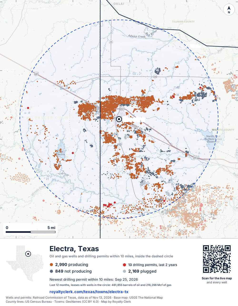
- Drilling locations13Permits issued in the last two years
- Producing wells2,990On a lease reporting production now
- Not producing849Shut in, inactive or no lease on record
- Plugged2,169The state's wellbore record says plugged
The dashed circle is 10 miles from the town's point (34.02926, -98.91896); the counts are for wells inside it. Sources: Railroad Commission of Texas well layers and permit files, US Census Bureau county outlines, town points from GeoNames (CC BY 4.0), base map from USGS The National Map.
Use this map on your site
You may show this map on any site, unchanged. Keep the credit line and its link to Royalty Clerk under the map. The picture updates by itself as the state records new wells and permits.
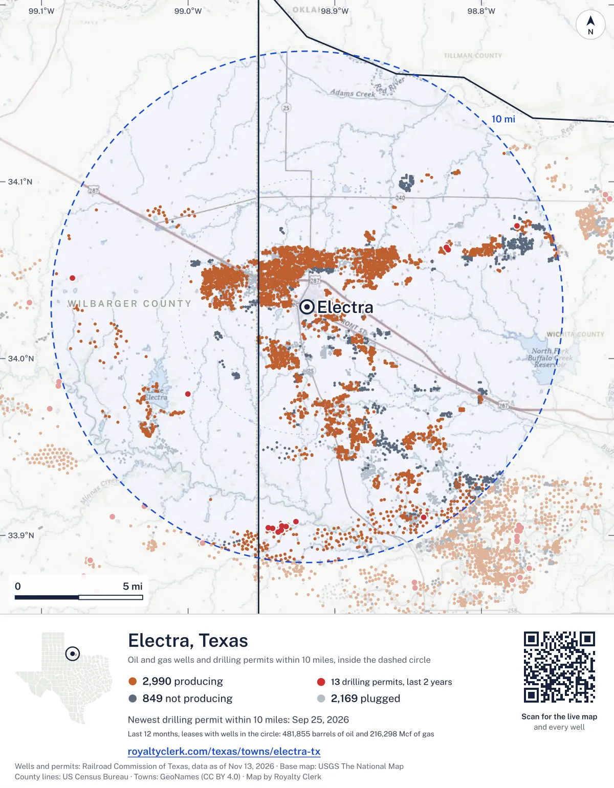
<a href="https://royaltyclerk.com/texas/towns/electra-tx"><img src="https://royaltyclerk.com/maps/town-wells/electra-tx.svg" alt="Map of Electra, Texas: 6,008 wells and 13 recent drilling locations within 10 miles, inside a dashed circle." width="1000" height="1284" loading="lazy" style="max-width:100%;height:auto;border:0"></a>
<p style="margin:4px 0 0;font-size:14px">Map: <a href="https://royaltyclerk.com/texas/towns/electra-tx">Electra, Texas oil and gas wells</a> by Royalty Clerk, from Railroad Commission of Texas records</p>
Which way it is heading
Where the new drilling is around Electra
What became of the 13 permits
- 4finished, on a lease that reports productionThe well was completed and its lease is reporting oil or gas to the state.
- 6drilling startedThe operator reported a start date. No completion is on file yet.
- 3still only a permitNothing after the permit is on file. Many permits wait a year or more, and some are never drilled.
Wells finished in the last two years: 3 south-east, 4 south, 4 west of town.
A permit is permission to drill, not a well, and a well nearby says nothing about who owns the minerals under it. Direction is taken from the well's surface location. Source: Railroad Commission of Texas drilling permits and wellbore records.
In numbers
Oil and gas within 10 miles of Electra
- wells with a location on the state's map
- 6,008
- drilling permits in the last 24 months
- 13
- producing leases with a well in the circle
- 254
- operators running them
- 48
- oil and condensate those leases reported in their latest 12 months
- 481,855 bbl
- gas those leases reported in their latest 12 months
- 216,298 mcf
A lease counts when at least one of its wells is inside the circle; its whole production is counted, so a lease reaching beyond the circle counts in full.
In dollars
What the oil and gas near Electra sold for
- sale value of 12 months, before taxes and costs
- $36 million
- oil and condensate sold
- 470,918 bbl
- gas sold
- 215,762 mcf
- the middle lease: half sold more, half less
- $65,424
A 0.01 share (1%) of the middle producing lease near Electra comes to about $654 for the 12 months.
Sold volumes at the public monthly prices, before severance tax and any costs. A guide to the size, not what any owner was paid.
Sold volumes from each lease's monthly report to the Railroad Commission, times the month's West Texas Intermediate oil price and Henry Hub gas price (EIA). Real prices at the lease differ. A lease counts in full when one of its wells is near the town. Check a statement against what the lease sold
Drilling locations
The newest drilling permits near Electra
| Issued | Lease and well | Where | Operator |
|---|---|---|---|
| 2026-09-25 | WAGGONER WEST HORSE 531EPvertical · API 42-487-33428 · permit 0918879Waggoner Operating, L.L.C. | 9.2 mi W34.04563, -99.07892 on OpenStreetMap (opens in a new tab) | Waggoner Operating, L.L.C. |
| 2026-09-18 | SAUDER A 11vertical · API 42-485-46435 · permit 0918471R2q Operating LLC | 8.6 mi S33.90509, -98.93336 on OpenStreetMap (opens in a new tab) | R2q Operating LLC |
| 2026-08-24 | THROCKMORTON 1vertical · API 42-485-46433 · permit 0917938Kodiak Oil & Gas, Inc. | 8.4 mi S33.90769, -98.92655 on OpenStreetMap (opens in a new tab) | Kodiak Oil & Gas, Inc. |
| 2026-05-12 | GILLIS, BRUCE 21Bvertical · API 42-485-46427 · permit 0914538Bonfire Operating LLC | 5.9 mi E34.06153, -98.82287 on OpenStreetMap (opens in a new tab) | Bonfire Operating LLC |
| 2026-05-12 | GILLIS, BRUCE 20Bvertical · API 42-485-46428 · permit 0914537Bonfire Operating LLC | 5.9 mi NE34.06293, -98.82400 on OpenStreetMap (opens in a new tab) | Bonfire Operating LLC |
| 2026-04-10 | POTTS TWO 10vertical · API 42-485-46425 · permit 0914706Mountain Creek Oil Company, Inc. | 8.7 mi S33.90427, -98.94540 on OpenStreetMap (opens in a new tab) | Mountain Creek Oil Company, Inc. |
| 2026-04-09 | SAUDER A 10vertical · API 42-485-46424 · permit 0914700R2q Operating LLC | 8.6 mi S33.90527, -98.93631 on OpenStreetMap (opens in a new tab) | R2q Operating LLC |
| 2026-04-09 | SAUDER A 9vertical · API 42-485-46426 · permit 0914688R2q Operating LLC | 8.8 mi S33.90307, -98.93633 on OpenStreetMap (opens in a new tab) | R2q Operating LLC |
| 2025-10-28 | SAUDER A 8vertical · API 42-485-46418 · permit 0911384R2q Operating LLC | 8.7 mi S33.90387, -98.94224 on OpenStreetMap (opens in a new tab) | R2q Operating LLC |
| 2025-07-16 | FOSTER, ED. ESTATE 15vertical · API 42-485-46411 · permit 0909256S&G Oil LLC | 8.8 mi E34.07494, -98.77585 on OpenStreetMap (opens in a new tab) | S&G Oil LLC |
| 2025-06-13 | SAUDER A 7vertical · API 42-485-46409 · permit 0908470R2q Operating LLC | 8.8 mi S33.90204, -98.93868 on OpenStreetMap (opens in a new tab) | R2q Operating LLC |
| 2025-01-07 | WAGGONER, J & J KMA UNIT 98vertical · API 42-485-46318 · permit 0904956R2q Operating LLC | 9.4 mi SE33.91031, -98.83951 on OpenStreetMap (opens in a new tab) | R2q Operating LLC |
| 2024-12-18 | WAGGONER EAST ELECTRA LAKE 71EPvertical · API 42-487-33410 · permit 0904753W.t. Waggoner Estate, Inc. | 5.8 mi SW33.97985, -99.00011 on OpenStreetMap (opens in a new tab) | W.t. Waggoner Estate, Inc. |
| 2024-11-07 | WAGGONER TWIN PEAKS 41EPvertical · API 42-487-33407 · permit 0903857W.t. Waggoner Estate, Inc. | 9.2 mi SW33.92964, -99.02643 on OpenStreetMap (opens in a new tab) | W.t. Waggoner Estate, Inc. |
| 2024-11-07 | WAGGONER BUTLER 1EPvertical · API 42-487-33406 · permit 0903856W.t. Waggoner Estate, Inc. | 7.5 mi SW33.95351, -99.01295 on OpenStreetMap (opens in a new tab) | W.t. Waggoner Estate, Inc. |
| 2024-11-06 | WAGGONER BDB 32EPvertical · API 42-487-33403 · permit 0903791W.t. Waggoner Estate, Inc. | 7.7 mi W34.02006, -99.05238 on OpenStreetMap (opens in a new tab) | W.t. Waggoner Estate, Inc. |
| 2024-10-31 | WAGGONER BDA 31EPvertical · API 42-487-33402 · permit 0903711W.t. Waggoner Estate, Inc. | 8.3 mi W34.01970, -99.06321 on OpenStreetMap (opens in a new tab) | W.t. Waggoner Estate, Inc. |
| 2024-10-21 | WAGGONER EBCC 102EPvertical · API 42-487-33399 · permit 0903401W.t. Waggoner Estate, Inc. | 7.0 mi W34.00734, -99.03749 on OpenStreetMap (opens in a new tab) | W.t. Waggoner Estate, Inc. |
| 2024-10-21 | WAGGONER EBCB 103EPvertical · API 42-487-33398 · permit 0903400W.t. Waggoner Estate, Inc. | 6.6 mi W34.00109, -99.02865 on OpenStreetMap (opens in a new tab) | W.t. Waggoner Estate, Inc. |
| 2024-10-11 | WAGGONER EBCA 101EPvertical · API 42-487-33397 · permit 0903186W.t. Waggoner Estate, Inc. | 7.2 mi W34.00995, -99.04187 on OpenStreetMap (opens in a new tab) | W.t. Waggoner Estate, Inc. |
| 2024-10-04 | SAUDER B 5vertical · API 42-485-46398 · permit 0903089R2q Operating LLC | 9.5 mi S33.89164, -98.92975 on OpenStreetMap (opens in a new tab) | R2q Operating LLC |
| 2024-07-31 | POTTS TWO 9vertical · API 42-485-46393 · permit 0901696Mountain Creek Oil Company, Inc. | 8.9 mi S33.90202, -98.94621 on OpenStreetMap (opens in a new tab) | Mountain Creek Oil Company, Inc. |
| 2022-02-09 | MARRIOTT, J.H. 60vertical · API 42-485-46232 · permit 0876705S&G Oil LLC | 2.8 mi NE34.04794, -98.87604 on OpenStreetMap (opens in a new tab) | S&G Oil LLC |
| 2022-02-07 | PARRISH 6vertical · API 42-485-46314 · permit 0876703S&G Oil LLC | 4.5 mi E34.05309, -98.84505 on OpenStreetMap (opens in a new tab) | S&G Oil LLC |
A permit is permission to drill, not a well. Distances are from the town's point to the well's surface location. Source: Railroad Commission of Texas drilling permits.
Find your land
The surveys under the new drilling near Electra
- A-114 H&TC RR CO, block 7, section 135 permits, newest September 18, 2026
- A-339 AB&M, section 112 permits, newest May 12, 2026
- A-75 H&TC RR CO, block 4, section 531 permit, newest September 25, 2026
- A-118 H&TC RR CO, block 7, section 231 permit, newest August 24, 2026
- A-544 TEMPLETON, M M, block 7, section 121 permit, newest April 10, 2026
- A-633 BARWISE, T H, section 21 permit, newest July 16, 2025
- A-387 BS&F, section 111 permit, newest January 7, 2025
- A-108 H&TC RR CO, block 5, section 71 permit, newest December 18, 2024
Not in the list? Search every survey in the county by name or abstract number.
Who is on the county roll
47 mineral accounts near Electra are still in the name of an estate
- mineral accounts on the roll
- 2,257
- owner names
- 580
- appraised value of those accounts
- $12 million
- the middle account's appraised value
- $230
- the middle account in all of Wichita County
- $340
- accounts titled to an estate
- 47
An account in the name of an estate usually means the owner died and the title was never moved to the heirs. The account stays on the roll, and these are appraised at $244,310 together. If a parent or grandparent owned minerals near Electra, their name may be one of them.
Totals from the county appraisal district's mineral roll, matched to leases by the state lease number. No owner is named here, and a count under 10 accounts or 5 owner names is left out. How Wichita County values minerals, and how to protest · Inherited minerals: where to start
Producing leases
Top producing leases near Electra
- 1Sauder A21,555 bbl · 0 mcf a yearR2q Operating LLC · Wichita County · 8 wells in the circle
- 2Waggoner Buoy Lease17,834 bbl · 0 mcf a yearWaggoner Operating, L.L.C. · Wichita County · 16 wells in the circle
- 3Stringer, J. W.12,595 bbl · 27,130 mcf a yearWaggoner Operating, L.L.C. · Wichita County · 215 wells in the circle
- 4Second Bywaters13,843 bbl · 13,126 mcf a yearWaggoner Operating, L.L.C. · Wichita County · 154 wells in the circle
- 5Allen, R. S.11,447 bbl · 22,094 mcf a yearWaggoner Operating, L.L.C. · Wichita County · 144 wells in the circle
- 6Waggoner, W. T. -A- NCT-312,507 bbl · 15,663 mcf a yearWaggoner Operating, L.L.C. · Wichita County · 40 wells in the circle
- 7Sumner, Frances8,930 bbl · 23,885 mcf a yearWaggoner Operating, L.L.C. · Wilbarger County · 192 wells in the circle
- 8Pudge12,057 bbl · 0 mcf a yearBurk Royalty Co., Ltd. · Wilbarger County · 2 wells in the circle
- 9Bywaters, B. A.10,075 bbl · 7,178 mcf a yearWaggoner Operating, L.L.C. · Wichita County · 130 wells in the circle
- 10Bradley Ranch10,346 bbl · 0 mcf a yearR2q Operating LLC · Wichita County · 2 wells in the circle
- 11Fee "Acc"10,178 bbl · 0 mcf a yearWaggoner Operating, L.L.C. · Wilbarger County · 15 wells in the circle
- 12Texfel Petroleum Corp.10,050 bbl · 0 mcf a yearQuatro Oil and Gas, Inc. · Wichita County · 3 wells in the circle
- 13Honaker, W. B. NCT-19,463 bbl · 903 mcf a yearWaggoner Operating, L.L.C. · Wichita County · 14 wells in the circle
- 14Waggoner, J & J "14"9,196 bbl · 0 mcf a yearQuatro Oil and Gas, Inc. · Wichita County · 5 wells in the circle
- 15Second Bywaters6,692 bbl · 6,762 mcf a yearWaggoner Operating, L.L.C. · Wichita County · 16 wells in the circle
- 16Waggoner -W-7,659 bbl · 0 mcf a yearBurk Royalty Co., Ltd. · Wilbarger County · 34 wells in the circle
- 17Waggoner, W. T. "E"2,298 bbl · 30,775 mcf a yearWaggoner Operating, L.L.C. · Wichita County · 7 wells in the circle
- 18Honaker, W. B. NCT-17,015 bbl · 560 mcf a yearWaggoner Operating, L.L.C. · Wichita County · 82 wells in the circle
- 19Skinner, Geo. S.4,263 bbl · 15,458 mcf a yearWaggoner Operating, L.L.C. · Wichita County · 34 wells in the circle
- 20Marriott, J. H.6,765 bbl · 0 mcf a yearS&G Oil LLC · Wichita County · 35 wells in the circle
Whose name is on the check
Who buys the oil and gas near Electra
Oil and condensate
- SENTINEL TRANSPORTATION, LLC141 leases
- PTT PREMIER TRADING AND TRAN LLC100 leases
- GULFMARK ENERGY, INC.13 leases
- CONOCO PIPE LINE COMPANY2 leases
- ENERGY TRANSFER MARKETING & TERM2 leases
From each lease's newest Form P-4 filing with the Railroad Commission, which names its gatherers and purchasers. One lease can name several.
If your checks stopped
Leases near Electra that went quiet or changed hands
40 leases reported nothing for a year or more
Leases that reported within the last four years and then stopped. The newest to stop first; 10 shown.
- Waggoner Kathy · Olenox Corp.last report July 2025
- Waggoner 'A' · W.t. Waggoner Estate, Inc.last report March 2025
- Moorhouse -A- · Sterling Oil and Gas LLClast report February 2025
- Jennings -A- · Sterling Oil and Gas LLClast report February 2025
- Lalk Bros. · Burk Royalty Co., Ltd.last report February 2025
- Burnett, S. B.-B- · Ray Loveless Enterprises, L.L.C.last report December 2024
- Obenhaus "A" · Roberts & Hammack Inc.last report December 2024
- Williamson · Rush Creek Operating LLClast report October 2024
- Whittenbach -B- · Rush Creek Operating LLClast report October 2024
- Whittenbach -A- · Rush Creek Operating LLClast report October 2024
109 leases got a new operator in two years
Checks often pause after a change while the new company sets up its owner records. The newest first; 10 shown.
- Allen, Red RiverDara Operating Company, LLC to Waggoner Operating, L.L.C.June 2026
- Allen, R. S.Dara Operating Company, LLC to Waggoner Operating, L.L.C.June 2026
- Bickley, W. P. & J. F.Dara Operating Company, LLC to Waggoner Operating, L.L.C.June 2026
- Bickley, W. P. & J. F.Dara Operating Company, LLC to Waggoner Operating, L.L.C.June 2026
- Brown & CrossDara Operating Company, LLC to Waggoner Operating, L.L.C.June 2026
- Bywaters, B. A.Dara Operating Company, LLC to Waggoner Operating, L.L.C.June 2026
- Corsicana HonakerDara Operating Company, LLC to Waggoner Operating, L.L.C.June 2026
- Corsicana-HonakerDara Operating Company, LLC to Waggoner Operating, L.L.C.June 2026
- First BywatersDara Operating Company, LLC to Waggoner Operating, L.L.C.June 2026
- First BywatersDara Operating Company, LLC to Waggoner Operating, L.L.C.June 2026
From the monthly production reports operators file with the Railroad Commission. The newest months fill in late, so a lease is listed only after 12 months with no report.
Year by year
Production of the leases near Electra, by year
| Year | Oil, bbl | Gas, mcf |
|---|---|---|
| 2026 so far | 312,715 | 141,997 |
| 2025 | 518,413 | 244,253 |
| 2024 | 604,799 | 247,108 |
| 2023 | 605,676 | 243,520 |
| 2022 | 625,186 | 258,890 |
| 2021 | 640,665 | 254,203 |
| 2020 | 688,925 | 253,289 |
Every lease with a well in the circle, producing now or not, as reported to the Railroad Commission. The newest months fill in as operators report.
The long view: in the state's records from January 1993 on, 419 of these leases reported 29,056,158 bbl of oil and condensate and 5,829,925 mcf of gas. Each lease page carries that lease's history back to January 1993.
Around it
Towns near Electra
- Iowa Park15 mi E5,704 wells · 21 permits
- Holliday20 mi SE4,869 wells · 37 permits
- Burkburnett21 mi E3,000 wells · 6 permits
- Vernon22 mi NW288 wells · 2 permits
- Wichita Falls26 mi E1,281 wells · 7 permits
Electra is in ZIP code 76360: its wells and permits
All of Wichita County: leases, operators and production · Wichita County well map
Press and community kit
Writing about Electra? Take what you need
Three facts to quote
- 6,008 oil and gas wells on the state's map lie within 10 miles of Electra: 2,990 on producing leases, 849 not producing and 2,169 plugged.
- The Railroad Commission of Texas issued 8 drilling permits within 10 miles of Electra in the last 12 months, the newest dated September 25, 2026.
- The 254 producing leases with a well in that circle, run by 48 operators, reported 481,855 barrels of oil and 216,298 thousand cubic feet of gas over their latest 12 months.
The map picture
The page's map with its legend and credit, as a JPEG.
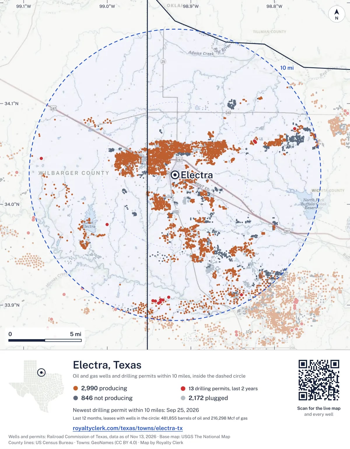
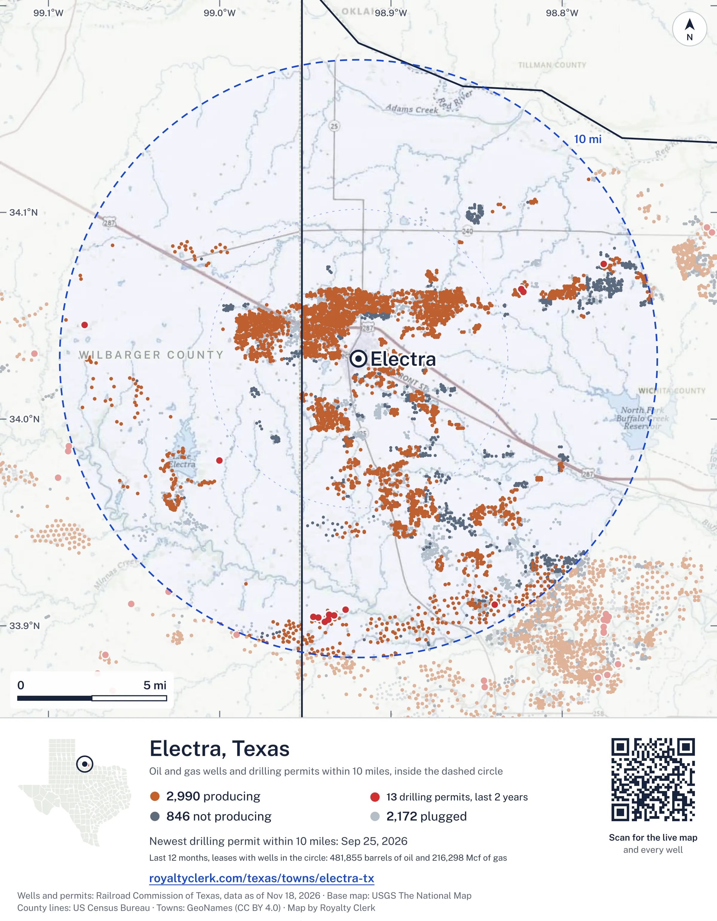
The live map on your page
A frame that loads its picture first and the live map on a tap. No cookies.
How to cite
Railroad Commission of Texas records of the wells and drilling permits within 10 miles of Electra, mapped by Royalty Clerk (https://royaltyclerk.com/texas/towns/electra-tx), data as of November 15, 2026.
Under a map or a chart: Source: Railroad Commission of Texas · Map: Royalty Clerk, with a link to this page.
The figures say where the state's records put wells and permits, not who owns the land or the minerals. Kits for other Texas towns
Follow it
Watch the 10 miles around Electra
Watching a place says nothing about who owns the land or the minerals there. For the whole county, or one survey, use the Wichita County well watch.
FAQ
Questions people ask
How many oil and gas wells are near Electra?
6,008 wells with a location on the Railroad Commission's map lie within 10 miles of Electra: 2,990 on leases that are producing, 849 not producing and 2,169 plugged. The state also issued 13 drilling permits with a well location in that circle in the last 24 months.
What are the coordinates on this page?
Latitude and longitude of the well's surface location in NAD83, the coordinates map apps use. They come from the Railroad Commission's well layers as published, and from its drilling permit files, which are published in the older NAD27 and converted here. Paste them into any map app. A horizontal well's bottom hole can be a mile or two away from its surface location.
Do I own minerals under a well near Electra?
A well nearby says nothing about who owns the minerals under it. The county's mineral roll lists who is paid on each producing lease. Search a name to see whether the Wichita County roll lists it.
Is drilling near Electra picking up or slowing down?
Drilling permits near Electra are rising: 8 permits in the last 12 months, 5 in the 12 months before. They are spread around town, with no side clearly ahead. The nearest is 5.8 miles south-west of the town's point. A permit is permission to drill, not a well.
How much are the oil and gas near Electra worth?
The 254 producing leases with a well within 10 miles sold about $36 million of oil and gas in their newest 12 months on file, at the public monthly prices and before taxes and costs. That is what the leases sold, not what a tract of land or a mineral interest is worth: an owner is paid a share of one lease.
A relative owned minerals near Electra and has died. What now?
The county mineral roll still lists 47 accounts in the name of an estate on leases near Electra. Search the family name first. If an account turns up, the title usually has to be moved to the heirs before the operator will pay them.
My checks from a lease here stopped. Why?
The usual reasons: the lease stopped producing, a new operator took it over, or the operator put the payments in suspense over a title or address question. Near Electra, 40 leases went quiet and 109 changed operator; both lists are on this page.
Own land or minerals near Electra?
47 accounts near Electra are still in the name of an estate. See whether a county roll lists your name, and get an email when a permit or a new well is filed near you.
Sources
Primary sources, opened on 29 September 2026. Statute text is the current version on statutes.capitol.texas.gov.