
Goliad County, Texas
Oil wells and drilling locations near Goliad
- 164wells
- 1drilling location in two years
- 55producing leases
Within 10 miles
Wells and drilling locations around Goliad
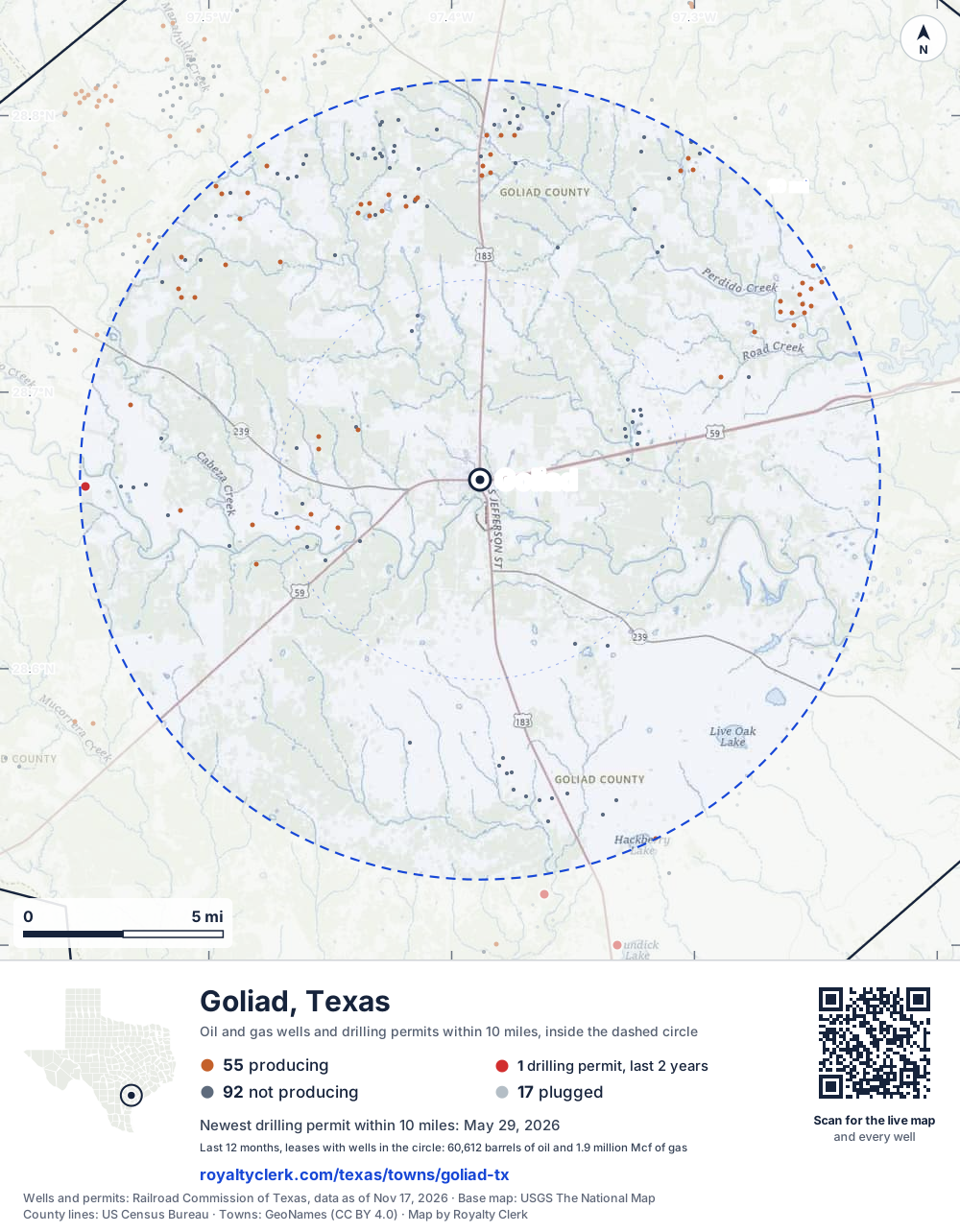
- Drilling locations1Permits issued in the last two years
- Producing wells55On a lease reporting production now
- Not producing93Shut in, inactive or no lease on record
- Plugged16The state's wellbore record says plugged
The dashed circle is 10 miles from the town's point (28.66833, -97.38833); the counts are for wells inside it. Sources: Railroad Commission of Texas well layers and permit files, US Census Bureau county outlines, town points from GeoNames (CC BY 4.0), base map from USGS The National Map.
Use this map on your site
You may show this map on any site, unchanged. Keep the credit line and its link to Royalty Clerk under the map. The picture updates by itself as the state records new wells and permits.
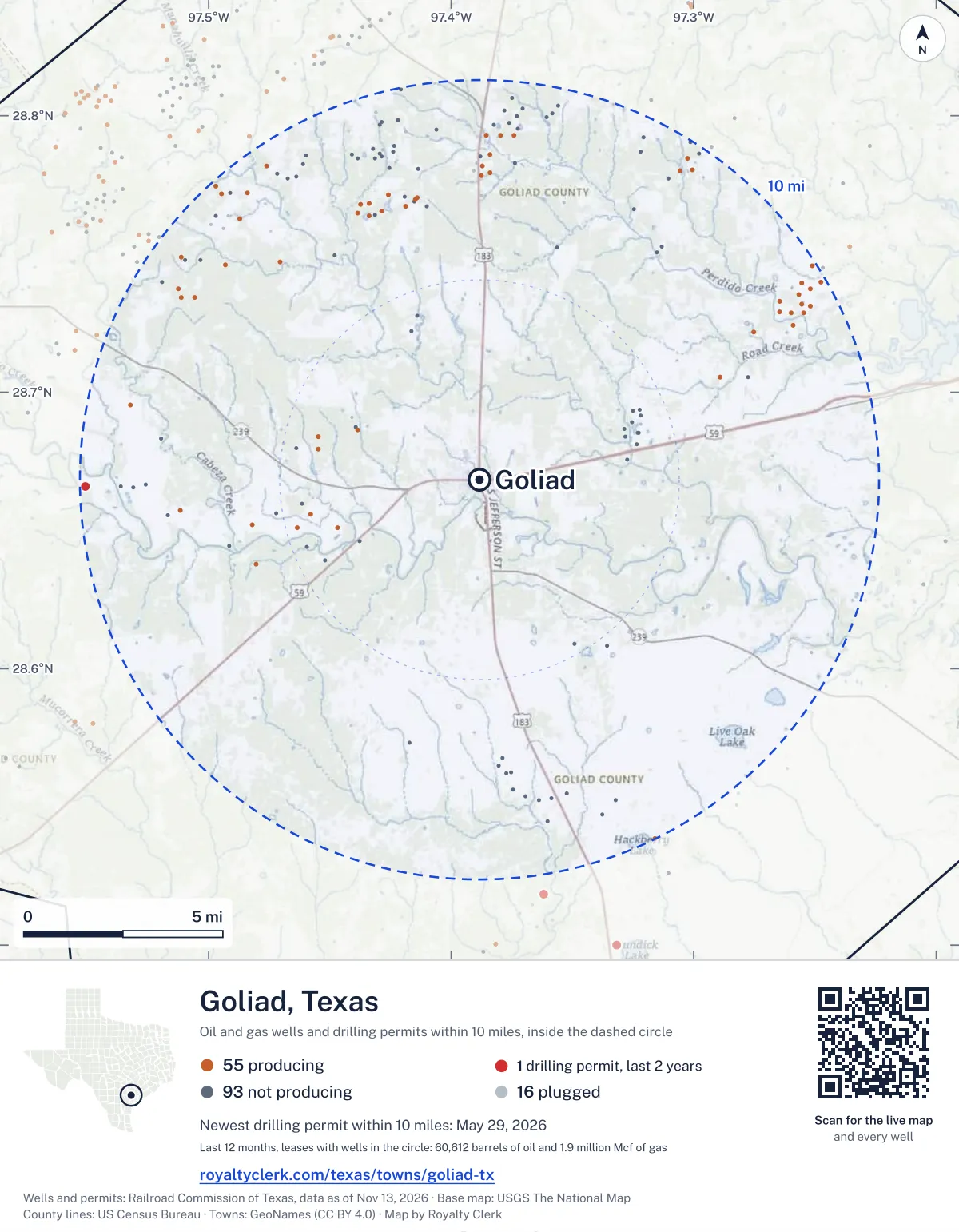
<a href="https://royaltyclerk.com/texas/towns/goliad-tx"><img src="https://royaltyclerk.com/maps/town-wells/goliad-tx.svg" alt="Map of Goliad, Texas: 164 wells and 1 recent drilling locations within 10 miles, inside a dashed circle." width="1000" height="1284" loading="lazy" style="max-width:100%;height:auto;border:0"></a>
<p style="margin:4px 0 0;font-size:14px">Map: <a href="https://royaltyclerk.com/texas/towns/goliad-tx">Goliad, Texas oil and gas wells</a> by Royalty Clerk, from Railroad Commission of Texas records</p>
Which way it is heading
Where the new drilling is around Goliad
What became of the 1 permit
- 1still only a permitNothing after the permit is on file. Many permits wait a year or more, and some are never drilled.
A horizontal well runs sideways underground. 1 starts inside and ends outside. So a well can drain land a mile or two from the spot where it shows on a map.
A permit is permission to drill, not a well, and a well nearby says nothing about who owns the minerals under it. Direction is taken from the well's surface location. Source: Railroad Commission of Texas drilling permits and wellbore records.
In numbers
Oil and gas within 10 miles of Goliad
- wells with a location on the state's map
- 164
- drilling permits in the last 24 months
- 1
- producing leases with a well in the circle
- 55
- operators running them
- 13
- oil and condensate those leases reported in their latest 12 months
- 60,612 bbl
- gas those leases reported in their latest 12 months
- 1,935,191 mcf
A lease counts when at least one of its wells is inside the circle; its whole production is counted, so a lease reaching beyond the circle counts in full.
In dollars
What the oil and gas near Goliad sold for
- sale value of 12 months, before taxes and costs
- $11 million
- oil and condensate sold
- 61,172 bbl
- gas sold
- 1,838,687 mcf
- the middle lease: half sold more, half less
- $41,085
A 0.01 share (1%) of the middle producing lease near Goliad comes to about $411 for the 12 months.
Sold volumes at the public monthly prices, before severance tax and any costs. A guide to the size, not what any owner was paid.
Sold volumes from each lease's monthly report to the Railroad Commission, times the month's West Texas Intermediate oil price and Henry Hub gas price (EIA). Real prices at the lease differ. A lease counts in full when one of its wells is near the town. Check a statement against what the lease sold
Drilling locations
The newest drilling permits near Goliad
| Issued | Lease and well | Where | Operator |
|---|---|---|---|
| 2026-05-29 | ALTA VISTA 1vertical · API 42-175-34264 · permit 0916013Viper S.w.d., LLC | 9.9 mi W28.66576, -97.55087 on OpenStreetMap (opens in a new tab) | Viper S.w.d., LLC |
| 2024-10-16 | PETTUS HEIRS 3vertical · API 42-175-33344 · permit 0899775Magnum Producing, LP | 9.0 mi W28.66575, -97.53612 on OpenStreetMap (opens in a new tab) | Magnum Producing, LP |
A permit is permission to drill, not a well. Distances are from the town's point to the well's surface location. Source: Railroad Commission of Texas drilling permits.
Find your land
The surveys under the new drilling near Goliad
- A-270 SOUTHERLAND, G1 permit, newest May 29, 2026
Not in the list? Search every survey in the county by name or abstract number.
Who is on the county roll
What the county mineral roll lists near Goliad
- mineral accounts on the roll
- 701
- owner names
- 437
- appraised value of those accounts
- $13 million
- the middle account's appraised value
- $460
- the middle account in all of Goliad County
- $660
Totals from the county appraisal district's mineral roll, matched to leases by the state lease number. No owner is named here, and a count under 10 accounts or 5 owner names is left out. How Goliad County values minerals, and how to protest · Inherited minerals: where to start
Producing leases
Top producing leases near Goliad
- 1Rob & Van Ramsey Unit42,312 bbl · 847,086 mcf a yearStroud Petroleum, Inc. · Goliad County · 1 well in the circle
- 2Ramsey2,716 bbl · 122,998 mcf a yearPaleo Oil Company LLC · Goliad County · 1 well in the circle
- 3Post621 bbl · 92,459 mcf a yearTranspacific Energy, LLC · Goliad County · 1 well in the circle
- 4Schendel A733 bbl · 90,101 mcf a yearBlack Oak Operating LLC · Goliad County · 1 well in the circle
- 5Bethke Roudon Gas Unit2,037 bbl · 69,252 mcf a yearNog Production & Operating LLC · Goliad County · 1 well in the circle
- 6Post300 bbl · 77,252 mcf a yearTranspacific Energy, LLC · Goliad County · 1 well in the circle
- 7Strong Gas Unit564 bbl · 75,049 mcf a yearTranspacific Energy, LLC · Goliad County · 1 well in the circle
- 8Strong Gas Unit158 bbl · 49,095 mcf a yearTranspacific Energy, LLC · Goliad County · 1 well in the circle
- 9Windberg, Dalhart633 bbl · 43,683 mcf a yearRemora Operating, LLC · Goliad County · 1 well in the circle
- 10Wood, Carrie0 bbl · 42,382 mcf a yearCharro Operating, L.L.C. · Goliad County · 1 well in the circle
- 11Worsham Gas Unit442 bbl · 37,277 mcf a yearAldine Oil and Gas, LP · Goliad County · 1 well in the circle
- 12Crews Gas Unit4,161 bbl · 13,842 mcf a yearAldine Oil and Gas, LP · Goliad County · 1 well in the circle
- 13Schendel A321 bbl · 32,680 mcf a yearBlack Oak Operating LLC · Goliad County · 1 well in the circle
- 14Roudon261 bbl · 30,404 mcf a yearNog Production & Operating LLC · Goliad County · 1 well in the circle
- 15Strong Gas Unit41 bbl · 29,132 mcf a yearTranspacific Energy, LLC · Goliad County · 1 well in the circle
- 16Strong Gas Unit0 bbl · 28,384 mcf a yearTranspacific Energy, LLC · Goliad County · 1 well in the circle
- 17Eichman - Lange Gas Unit250 bbl · 21,985 mcf a yearRemora Operating, LLC · Goliad County · 1 well in the circle
- 18Robinson-Reaves247 bbl · 21,957 mcf a yearRemora Operating, LLC · Goliad County · 1 well in the circle
- 19Robinson-Reaves206 bbl · 22,101 mcf a yearRemora Operating, LLC · Goliad County · 1 well in the circle
- 20Robinson-Reaves345 bbl · 21,047 mcf a yearRemora Operating, LLC · Goliad County · 1 well in the circle
Whose name is on the check
Who buys the oil and gas near Goliad
Oil and condensate
- GULFMARK ENERGY, INC.43 leases
- SYNERGY TRANSFER, LLC7 leases
- ACE GATHERING, INC.6 leases
- DORADO OIL COMPANY3 leases
- ENERGY TRANSFER MARKETING & TERM3 leases
Gas
- REPUBLIC COAST PIPELINE, LLC17 leases
- HOUSTON PIPE LINE COMPANY LP13 leases
- DCP OPERATING COMPANY, LP11 leases
- GULF COAST ENERGY, INC.5 leases
- TPL SOUTHTEX MIDSTREAM LLC3 leases
From each lease's newest Form P-4 filing with the Railroad Commission, which names its gatherers and purchasers. One lease can name several.
If your checks stopped
Leases near Goliad that went quiet or changed hands
17 leases reported nothing for a year or more
Leases that reported within the last four years and then stopped. The newest to stop first; 10 shown.
- O'Connor Ranch · Proline Energy Resources Inclast report April 2025
- Dohmann "A" · Nog Production & Operating LLClast report March 2025
- Pettus Heirs · Magnum Producing, LPlast report January 2025
- Albrecht, V. · Rock Resources, Inc.last report August 2024
- Sievers · Apv McCamey LLClast report May 2024
- Franke · Mercy Oil and Gas, LPlast report August 2023
- Cascadia #2 · Mercy Oil and Gas, LPlast report August 2023
- Justen, Elizabeth · Houston Gulf Energy Corporationlast report April 2023
- Dohmann 80 · Houston Gulf Energy Corporationlast report April 2023
- Arnecke A · Saddle Lake Energy, LLClast report October 2022
10 leases got a new operator in two years
Checks often pause after a change while the new company sets up its owner records. The newest first.
- PattonVentex Operating Corp. to Black Oak Operating LLCMay 2026
- Patton UnitVentex Operating Corp. to Black Oak Operating LLCMay 2026
- Schendel AVentex Operating Corp. to Black Oak Operating LLCMay 2026
- Schendel AVentex Operating Corp. to Black Oak Operating LLCMay 2026
- Rob & Van Ramsey UnitVentex Operating Corp. to Stroud Petroleum, Inc.March 2026
- Roudon ARemora Operating, LLC to Nog Production & Operating LLCJanuary 2026
- Alta VistaPaleo Oil Company LLC to Viper S.w.d., LLCDecember 2025
- Albrecht, Arco V.Dewbre Petroleum Corporation to Nog Production & Operating LLCOctober 2025
- Bethke Roudon Gas UnitRemora Operating, LLC to Nog Production & Operating LLCMarch 2025
- RoudonRemora Operating, LLC to Nog Production & Operating LLCMarch 2025
From the monthly production reports operators file with the Railroad Commission. The newest months fill in late, so a lease is listed only after 12 months with no report.
Year by year
Production of the leases near Goliad, by year
| Year | Oil, bbl | Gas, mcf |
|---|---|---|
| 2026 so far | 40,012 | 1,284,036 |
| 2025 | 52,922 | 1,715,859 |
| 2024 | 18,035 | 1,000,572 |
| 2023 | 16,288 | 1,023,275 |
| 2022 | 18,383 | 1,253,715 |
| 2021 | 34,701 | 1,606,401 |
| 2020 | 27,000 | 1,888,103 |
Every lease with a well in the circle, producing now or not, as reported to the Railroad Commission. The newest months fill in as operators report.
The long view: in the state's records from January 1993 on, 162 of these leases reported 3,153,968 bbl of oil and condensate and 192,026,725 mcf of gas. Each lease page carries that lease's history back to January 1993.
Around it
Towns near Goliad
- Quail Creek20 mi E200 wells · 3 permits
- Yorktown23 mi N1,197 wells · 129 permits
- Runge25 mi NW1,900 wells · 166 permits
- Victoria25 mi E213 wells · 3 permits
- Refugio26 mi S1,097 wells · 18 permits
- Beeville29 mi SW255 wells · 9 permits
- Kenedy30 mi W2,160 wells · 119 permits
- Woodsboro30 mi S401 wells · 18 permits
- Cuero30 mi N307 wells · 33 permits
Goliad is in ZIP code 77963: its wells and permits
All of Goliad County: leases, operators and production · Goliad County well map
Follow it
Watch the 10 miles around Goliad
Watching a place says nothing about who owns the land or the minerals there. For the whole county, or one survey, use the Goliad County well watch.
FAQ
Questions people ask
How many oil and gas wells are near Goliad?
164 wells with a location on the Railroad Commission's map lie within 10 miles of Goliad: 55 on leases that are producing, 93 not producing and 16 plugged. The state also issued 1 drilling permit with a well location in that circle in the last 24 months.
What are the coordinates on this page?
Latitude and longitude of the well's surface location in NAD83, the coordinates map apps use. They come from the Railroad Commission's well layers as published, and from its drilling permit files, which are published in the older NAD27 and converted here. Paste them into any map app. A horizontal well's bottom hole can be a mile or two away from its surface location.
Do I own minerals under a well near Goliad?
A well nearby says nothing about who owns the minerals under it. The county's mineral roll lists who is paid on each producing lease. Search a name to see whether the Goliad County roll lists it.
Is drilling near Goliad picking up or slowing down?
Drilling permits near Goliad are new: 1 permit in the last 12 months, 0 in the 12 months before. The nearest is 9.9 miles west of the town's point. A permit is permission to drill, not a well.
How much are the oil and gas near Goliad worth?
The 55 producing leases with a well within 10 miles sold about $11 million of oil and gas in their newest 12 months on file, at the public monthly prices and before taxes and costs. That is what the leases sold, not what a tract of land or a mineral interest is worth: an owner is paid a share of one lease.
My checks from a lease here stopped. Why?
The usual reasons: the lease stopped producing, a new operator took it over, or the operator put the payments in suspense over a title or address question. Near Goliad, 17 leases went quiet and 10 changed operator; both lists are on this page.
Own land or minerals near Goliad?
See whether a county roll lists your name, and get an email when a permit or a new well is filed near you.
Sources
Primary sources, opened on 29 September 2026. Statute text is the current version on statutes.capitol.texas.gov.