
Archer County, Texas
Archer County drilling permits: what the state recorded
- 55drilling permits
- 36completions
- 8first-production reports
- in the last twelve months
Wells by coordinates
Oil wells and drilling locations in Archer County
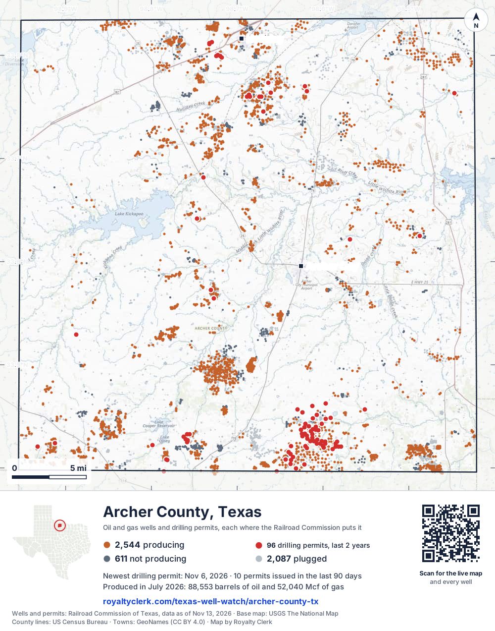
- Drilling locations96Permits issued in the last two years
- Producing wells2,544On a lease reporting production now
- Not producing611Shut in, inactive or no lease on record
- Plugged2,087The state's wellbore record says plugged
Sources: Railroad Commission of Texas well layers and permit files, US Census Bureau county outline, town points from GeoNames (CC BY 4.0), base map from USGS The National Map. A dot is a surface location; a horizontal well runs a mile or more from it.
5,242 wells with a location on the state's map and 96 drilling locations permitted in the last 24 months, each where the Railroad Commission puts it.
A permit is not a well.
Archer County is one of the 25 counties of the Barnett Shale
Wells near each town in Archer County
Wells within 10 miles of each town, on either side of the county line.
Use this map on your site
You may show this map on any site, unchanged. Keep the credit line and its link to Royalty Clerk under the map. The picture updates by itself as the state records new wells and permits.
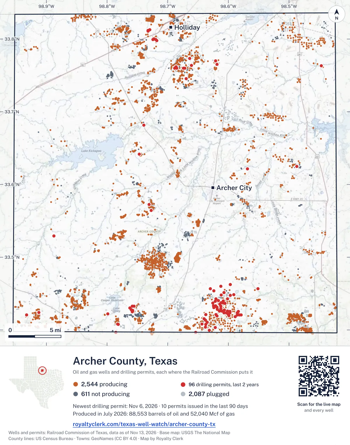
<a href="https://royaltyclerk.com/texas-well-watch/archer-county-tx"><img src="https://royaltyclerk.com/maps/county-wells/archer-county-tx.svg" alt="Map of Archer County, Texas, with 5,242 oil and gas wells and 96 recent drilling locations as dots." width="1000" height="1273" loading="lazy" style="max-width:100%;height:auto;border:0"></a>
<p style="margin:4px 0 0;font-size:14px">Map: <a href="https://royaltyclerk.com/texas-well-watch/archer-county-tx">Archer County, Texas oil and gas wells</a> by Royalty Clerk, from Railroad Commission of Texas records</p>
The last twelve months
Month by month in Archer County
| Month | Permits | Completions | First production |
|---|---|---|---|
| Nov 2026 | 3 | 0 | 0 |
| Oct 2026 | 5 | 0 | 0 |
| Sep 2026 | 1 | 2 | 0 |
| Aug 2026 | 5 | 0 | 0 |
| Jul 2026 | 4 | 4 | 2 |
| Jun 2026 | 7 | 8 | 3 |
| May 2026 | 10 | 3 | 0 |
| Apr 2026 | 3 | 7 | 2 |
| Mar 2026 | 6 | 3 | 0 |
| Feb 2026 | 4 | 1 | 0 |
| Jan 2026 | 6 | 2 | 0 |
| Dec 2025 | 0 | 4 | 1 |
| Nov 2025 | 1 | 2 | 0 |
Counted from November 15, 2025 to November 6, 2026, so the first and last months are partial. Source: Railroad Commission of Texas data sets.
Free, no sign-in
The newest drilling permits in Archer County
| Issued | Lease and well | Operator | Drilling began | Depth, ft | API number | Coordinates | Permit |
|---|---|---|---|---|---|---|---|
| 2026-11-06 | BRIDWELL ARCHER RANCH -D- 9new drill · verticalBridwell Oil Co.API 42-009-43449 · permit 091982933.42339, -98.585136,000 ft | Bridwell Oil Co. | |||||
| 2026-11-05 | BENSON 170 1new drill · verticalB.o.l.d. Oil and Gas, LLCAPI 42-009-43451 · permit 091988633.40323, -98.621715,999 ft | B.o.l.d. Oil and Gas, LLC | |||||
| 2026-11-02 | BRIDWELL ARCHER RANCH -100- 3new drill · verticalBridwell Oil Co.API 42-009-43450 · permit 091985233.41810, -98.588566,000 ft | Bridwell Oil Co. | |||||
| 2026-10-27 | ANDREWS, M.P. -C- 16new drill · verticalWilcox Energy Company LLCAPI 42-009-43448 · permit 091960633.42339, -98.607514,999 ft | Wilcox Energy Company LLC | |||||
| 2026-10-27 | ANDREWS, M.P. -C- 15new drill · verticalWilcox Energy Company LLCAPI 42-009-43447 · permit 091960133.42165, -98.600304,999 ft | Wilcox Energy Company LLC | |||||
| 2026-10-21 | BASIN 326.125 1new drill · verticalPlains Marketing, L.P.API 42-009-43446 · permit 091925833.77014, -98.62091300 ft | Plains Marketing, L.P. | |||||
| 2026-10-20 | RICHARDSON -A- 9new drill · verticalOlney Oil LLCAPI 42-009-43445 · permit 091942633.42680, -98.757591,300 ft | Olney Oil LLC | |||||
| 2026-10-20 | DEITRICH -C- 2Cnew drill · verticalGuidance Oil DevelopersAPI 42-009-43444 · permit 091942733.39651, -98.785461,300 ft | Guidance Oil Developers | |||||
| 2026-09-08 | ANDREWS 'D' 1new drill · verticalBorderline Operating Corp.API 42-009-43443 · permit 091829033.44855, -98.591315,999 ft | Borderline Operating Corp. | |||||
| 2026-08-26 | ANDREWS NORTH 2new drill · verticalBorderline Operating Corp.API 42-009-43442 · permit 091809333.45160, -98.607325,100 ft | Borderline Operating Corp. | |||||
| 2026-08-05 | HF SINCLAIR T012MPnew drill · verticalWbi Energy Midstream, LLCAPI 42-009-43433 · permit 091601133.74572, -98.66964drilling began 2026-08-19 · 350 ft | Wbi Energy Midstream, LLC | |||||
| 2026-08-03 | ANDREWS LONGLEY 5new drill · verticalJMH Production, LLCAPI 42-009-43441 · permit 091751933.43984, -98.608175,200 ft | JMH Production, LLC | |||||
| 2026-08-03 | ANDREWS 'A' 14new drill · verticalBorderline Operating Corp.API 42-009-43440 · permit 091751533.43105, -98.618495,500 ft | Borderline Operating Corp. | |||||
| 2026-08-03 | HF SINCLAIR T013MPnew drill · verticalWbi Energy Midstream, LLCAPI 42-009-43437 · permit 091601533.52924, -98.88780drilling began 2026-08-13 · 350 ft | Wbi Energy Midstream, LLC | |||||
| 2026-07-10 | PROTHRO 108new drill · verticalNewport Operating, LLCAPI 42-009-43439 · permit 091701633.81257, -98.729822,000 ft | Newport Operating, LLC | |||||
| 2026-07-06 | MATUS 9new drill · verticalGuidance Oil Developers,inc.(1)API 42-009-43436 · permit 091662733.42048, -98.932701,500 ft | Guidance Oil Developers,inc.(1) | |||||
| 2026-07-01 | BENSON ESTATE -E- 14new drill · verticalWilcox Energy Company LLCAPI 42-009-43438 · permit 091673333.41324, -98.63789drilling began 2026-07-14 · 1,500 ft | Wilcox Energy Company LLC | |||||
| 2026-07-01 | MUSTANG 6new drill · verticalEagle Oil & Gas Co.API 42-009-43435 · permit 091641633.43062, -98.623855,500 ft | Eagle Oil & Gas Co. | |||||
| 2026-06-30 | HILL R. E. 50new drill · verticalPalmer Operating LLCAPI 42-009-43434 · permit 091643433.42393, -98.912221,900 ft | Palmer Operating LLC | |||||
| 2026-06-15 | HULL-SILK 4300' UNIT 76Mrecompletion · verticalBlackflat Oil Company LLCAPI 42-009-43127 · permit 091634633.77342, -98.66352drilling began 2018-01-20 · 5,156 ft | Blackflat Oil Company LLC | |||||
| 2026-06-15 | MUSTANG 4new drill · verticalEagle Oil & Gas Co.API 42-009-43431 · permit 091615433.43062, -98.623855,500 ft | Eagle Oil & Gas Co. | |||||
| 2026-06-15 | HULL SILK 4000-FOOT LIME UNIT 502recompletion · verticalLewis Operating CompanyAPI 42-009-42549 · permit 091607333.75995, -98.685014,750 ft | Lewis Operating Company | |||||
| 2026-06-15 | HULL SILK 4000-FOOT LIME UNIT 501recompletion · verticalLewis Operating CompanyAPI 42-009-42548 · permit 091606833.76195, -98.686394,750 ft | Lewis Operating Company | |||||
| 2026-06-12 | HORNED FROG 1new drill · verticalEagle Oil & Gas Co.API 42-009-43432 · permit 091625233.44023, -98.61642drilling began 2026-07-07 · 1,500 ft | Eagle Oil & Gas Co. | |||||
| 2026-06-05 | MAY RUTTY A 3recompletion · verticalLewis Operating CompanyAPI 42-009-42617 · permit 091606633.76002, -98.688825,000 ft | Lewis Operating Company | |||||
| 2026-05-29 | COWAN MCKINNEY -Y- 3new drill · verticalB.o.l.d. Oil and Gas, LLCAPI 42-009-43430 · permit 091595533.46017, -98.612215,999 ft | B.o.l.d. Oil and Gas, LLC | |||||
| 2026-05-29 | COWAN MCKINNEY -Y- 2new drill · verticalB.o.l.d. Oil and Gas, LLCAPI 42-009-43429 · permit 091595433.45379, -98.623985,999 ft | B.o.l.d. Oil and Gas, LLC | |||||
| 2026-05-29 | COWAN MCKINNEY -Y- 1new drill · verticalB.o.l.d. Oil and Gas, LLCAPI 42-009-43428 · permit 091591133.45673, -98.629505,999 ft | B.o.l.d. Oil and Gas, LLC | |||||
| 2026-05-18 | WESTFORK 4new drill · verticalBridwell Oil Co.API 42-009-43427 · permit 091564233.42605, -98.601206,000 ft | Bridwell Oil Co. | |||||
| 2026-05-14 | MUSTANG 3new drill · verticalEagle Oil & Gas Co.API 42-009-43426 · permit 091546233.43318, -98.62450drilling began 2026-08-14 · 5,500 ft | Eagle Oil & Gas Co. | |||||
| 2026-05-14 | MUSTANG 2new drill · verticalEagle Oil & Gas Co.API 42-009-43425 · permit 091545733.43710, -98.62576drilling began 2026-08-05 · 5,500 ft | Eagle Oil & Gas Co. | |||||
| 2026-05-12 | TURBEVILLE B 3new drill · verticalEagle Oil & Gas Co.API 42-009-43424 · permit 091545633.44266, -98.62042drilling began 2026-08-03 · 5,500 ft | Eagle Oil & Gas Co. | |||||
| 2026-05-12 | CAMPBELL 400 1new drill · verticalB.o.l.d. Oil and Gas, LLCAPI 42-009-43421 · permit 091485233.40797, -98.64363drilling began 2026-05-20 · 4,999 ft | B.o.l.d. Oil and Gas, LLC | |||||
| 2026-05-06 | BENSON 180 2recompletion · verticalB.o.l.d. Oil and Gas, LLCAPI 42-009-43400 · permit 091532833.40769, -98.637015,500 ft | B.o.l.d. Oil and Gas, LLC | |||||
| 2026-05-04 | STEVEN ATCHLEY LEASE 5Anew drill · verticalGuidance Oil Developers,inc.(1)API 42-009-43423 · permit 091529533.42196, -98.79850drilling began 2026-05-18 · 1,400 ft | Guidance Oil Developers,inc.(1) | |||||
| 2026-04-28 | CAMPBELL 400 2new drill · verticalB.o.l.d. Oil and Gas, LLCAPI 42-009-43422 · permit 091491333.39681, -98.653685,999 ft | B.o.l.d. Oil and Gas, LLC | |||||
| 2026-04-07 | BENSON 180 3new drill · verticalB.o.l.d. Oil and Gas, LLCAPI 42-009-43420 · permit 091444633.41044, -98.634854,999 ft | B.o.l.d. Oil and Gas, LLC | |||||
| 2026-04-07 | VIETH, A.P. 7field transfer · verticalVeteran Exploration & Prod, LLCAPI 42-009-41556 · permit 091368733.62483, -98.48708drilling began 2006-06-10 · 5,606 ft | Veteran Exploration & Prod, LLC | |||||
| 2026-03-24 | ANDREWS-LUIG 9field transfer · verticalPowder River Resources, LLCAPI 42-009-43299 · permit 091424233.41974, -98.599164,810 ft | Powder River Resources, LLC | |||||
| 2026-03-24 | ANDREWS-LUIG 3new drill · verticalPowder River Resources, LLCAPI 42-009-43419 · permit 091423633.42339, -98.59757drilling began 2026-06-08 · 5,200 ft | Powder River Resources, LLC | |||||
| 2026-03-17 | BENSON ESTATE -E- 13new drill · verticalWilcox Energy Company LLCAPI 42-009-43417 · permit 091399733.41350, -98.637914,999 ft | Wilcox Energy Company LLC | |||||
| 2026-03-13 | ANDREWS, M.P. -C- 14new drill · verticalWilcox Energy Company LLCAPI 42-009-43418 · permit 091404633.42377, -98.603164,999 ft | Wilcox Energy Company LLC | |||||
| 2026-03-06 | BRIDWELL ARCHER RANCH -C- 2new drill · verticalBridwell Oil Co.API 42-009-43416 · permit 091387133.42086, -98.57874drilling began 2026-05-18 · 6,000 ft | Bridwell Oil Co. | |||||
| 2026-03-06 | WESTFORK 3new drill · verticalBridwell Oil Co.API 42-009-43415 · permit 091387033.42570, -98.597497,000 ft | Bridwell Oil Co. | |||||
| 2026-02-26 | RICHARDSON -A- 8new drill · verticalOlney Oil LLCAPI 42-009-43414 · permit 091361533.42607, -98.75757drilling began 2026-02-25 · 1,300 ft | Olney Oil LLC | |||||
| 2026-02-05 | RICHARDSON -A- 7new drill · verticalOlney Oil LLCAPI 42-009-43413 · permit 091319733.42511, -98.75859drilling began 2026-02-19 · 1,300 ft | Olney Oil LLC | |||||
| 2026-02-05 | WHITE UNIT 1011recompletion · verticalClark Operating Inc.API 42-009-86667 · permit 091317733.76531, -98.61895drilling began 1940-09-24 · 4,000 ft | Clark Operating Inc. | |||||
| 2026-02-04 | BENSON 40 UNIT 1recompletion · verticalB.o.l.d. Oil and Gas, LLCAPI 42-009-43368 · permit 091303833.39956, -98.631445,041 ft | B.o.l.d. Oil and Gas, LLC | |||||
| 2026-01-13 | TURBEVILLE B 2new drill · verticalEagle Oil & Gas Co.API 42-009-43411 · permit 091258033.43965, -98.62174drilling began 2026-02-07 · 5,200 ft | Eagle Oil & Gas Co. | |||||
| 2026-01-08 | MUSTANG 1new drill · verticalEagle Oil & Gas Co.API 42-009-43412 · permit 091257433.43341, -98.62088drilling began 2026-02-18 · 5,400 ft | Eagle Oil & Gas Co. |
These are the newest 50 of 139 permits on file for Archer County. The rest follow, 50 to a page.
A permit is permission to drill, not a well. Source: Railroad Commission of Texas drilling permit files.
Year by year
Drilling permits issued in Archer County, by year
| Year | Permits issued |
|---|---|
| 2026 so far | 54 |
| 2025 | 38 |
| 2024 | 31 |
| 2023 | 14 |
| 2022 | 1 |
| 2013 | 1 |
Counted from the permit files we hold, which start in 2013; that first year may be partial. Source: Railroad Commission of Texas drilling permit files.
The latest
The most recent records
| Date | What, who and where |
|---|---|
| 2026-11-06 | Permit issued: Bridwell Oil Co.BRIDWELL ARCHER RANCH -D- · A-510 · permit 0919829 |
| 2026-11-05 | Permit issued: B.o.l.d. Oil and Gas, LLCBENSON 170 · A-476 · permit 0919886 |
| 2026-11-02 | Permit issued: Bridwell Oil Co.BRIDWELL ARCHER RANCH -100- · A-510 · permit 0919852 |
| 2026-10-27 | Permit issued: Wilcox Energy Company LLCANDREWS, M.P. -C- · A-509 · permit 0919601 |
| 2026-10-27 | Permit issued: Wilcox Energy Company LLCANDREWS, M.P. -C- · A-508 · permit 0919606 |
| 2026-10-21 | Permit issued: Plains Marketing, L.P.BASIN 326.125 · A-4 · permit 0919258 |
| 2026-10-20 | Permit issued: Guidance Oil DevelopersDEITRICH -C- · A-1150 · permit 0919427 |
| 2026-10-20 | Permit issued: Olney Oil LLCRICHARDSON -A- · A-269 · permit 0919426 |
| 2026-09-08 | Permit issued: Borderline Operating Corp.ANDREWS 'D' · A-733 · permit 0918290 |
| 2026-09-03 | Completed: Borderline Operating Corp.ANDREWS 'A' · A-184 · permit 0912496 |
| 2026-09-01 | Completed: SBG Resources Group LLCGARVEY, C. K. -C- · A-539 |
| 2026-08-26 | Permit issued: Borderline Operating Corp.ANDREWS NORTH · A-129 · permit 0918093 |
| 2026-08-05 | Permit issued: Wbi Energy Midstream, LLCHF SINCLAIR · A-409 · permit 0916011 |
| 2026-08-03 | Permit issued: JMH Production, LLCANDREWS LONGLEY · A-184 · permit 0917519 |
| 2026-08-03 | Permit issued: Borderline Operating Corp.ANDREWS 'A' · A-674 · permit 0917515 |
Coming up
First checks coming due in Archer County
- Wilson Spr, Crampton, Freddieby November 28, 2026
- Campbell 400, B.o.l.d. Oil and Gas, LLCby November 28, 2026
- ANDREWS 'A', Borderline Operating Corp.by November 28, 2026
- ANDREWS-LUIG, Powder River Resources, LLCby November 28, 2026
- BENSON ESTATE -E-, Wilcox Energy Company LLCby November 28, 2026
- GARVEY, C. K. -C-, SBG Resources Group LLCby January 28, 2027
- ANDREWS 'A', Borderline Operating Corp.by January 28, 2027
Follow it
Watch Archer County, or one abstract
What do you want to follow?
Where the land is. Your deed or lease names it.
For example A-1119, or Bush, or T&P 38. Your deed or the tax bill has it.
Other counties
Drilling activity in other counties
Related
Related
- ToolTexas well watchPermit, completion, first production and when the first check is due.
- ToolIs this buyout offer fair?The offer as months of your income, what the acres mean, and the questions to ask.
- ToolIs this lease offer good?Bonus and royalty against the county, and a scan of the lease's clauses.
- Texas dataTexas operator changesWho took over whose leases in the last 24 months.
- ToolLate payment interestDeadlines and the interest a late payment earns.
- Texas dataTexas oil and gas atlas254 counties, every lease, operator and field.
FAQ
Questions people ask
How many wells were permitted in Archer County in the last year?
The Railroad Commission issued 55 drilling permits in Archer County in the twelve months to November 6, 2026, and recorded 36 completions and 8 first-production reports. A permit is permission to drill, not a well.
How do I get an alert when a permit is issued near my land in Archer County?
Choose your abstract on this page, or the whole county, and sign in. You get one email a week, only when something new is recorded after you sign up. The alert says whether an event is on an interest in your Mineral File, on a place you follow, or only nearby.
When is my first royalty check due after a new well?
Natural Resources Code section 91.402(a) says on or before 120 days after the end of the month of first sale of production from the well. The state's first-production month is the closest public marker, so the date on this page is the earliest, not a certainty.
Got a new well on your land?
The first check is due within 120 days after the end of the month of first sale.
Sources
Primary sources, opened on 29 September 2026. Statute text is the current version on statutes.capitol.texas.gov.