
Railroad Commission of Texas · Districts 5, 7B and 9 · 25 counties
Barnett Shale
- 274drilling permits in 12 months
- 3%of the state's permits
- 56,321wells on the map
- 71operators filing
Where it is drilled
The Barnett Shale's wells and new permits
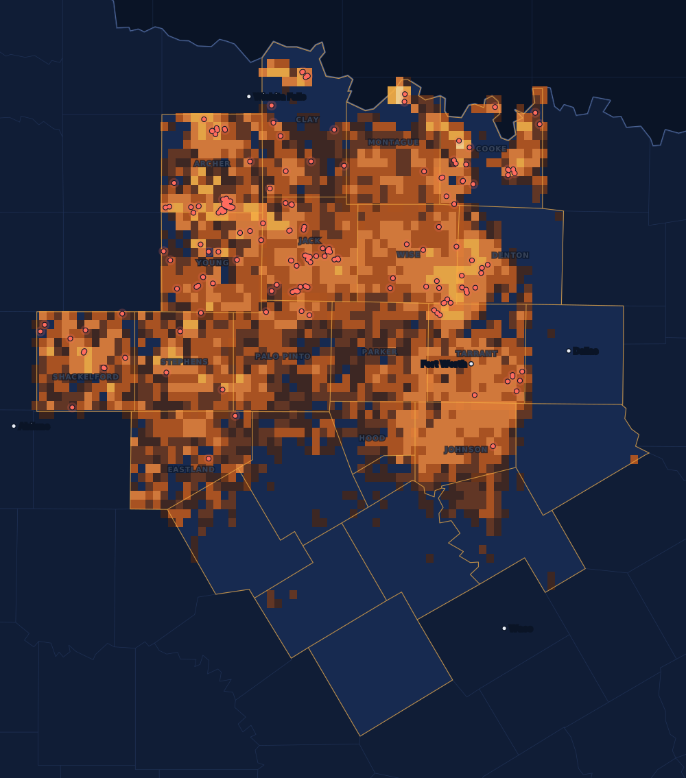
A gas shale that reaches west and south from Dallas over about 5,000 square miles, one of the largest onshore natural gas fields in the United States. The state names its productive part the Newark, East (Barnett Shale) field.
Counties
The 25 counties, by permits
Drilling permits of the last 12 months in each county, and the wells on the state's map there. Each county's live map shows every well and permit where the state puts it.
- 1Archer County555,242 wells on the mapLive map
- 2Jack County494,421 wells on the mapLive map
- 3Cooke County293,853 wells on the mapLive map
- 4Wise County285,625 wells on the mapLive map
- 5Tarrant County274,490 wells on the mapLive map
- 6Shackelford County213,190 wells on the mapLive map
- 7Clay County192,177 wells on the mapLive map
- 8Young County174,499 wells on the mapLive map
- 9Denton County153,232 wells on the mapLive map
- 10Montague County44,175 wells on the mapLive map
- 11Stephens County43,717 wells on the mapLive map
- 12Palo Pinto County32,247 wells on the mapLive map
- 13Eastland County22,012 wells on the mapLive map
- 14Johnson County13,589 wells on the mapLive map
- 15Parker County01,895 wells on the mapLive map
- 16Hood County0865 wells on the mapLive map
The other 9 counties, A to Z
- Bosque County0 permits · 10 wells
- Comanche County0 permits · 234 wells
- Coryell County0 permits · 0 wells
- Dallas County0 permits · 74 wells
- Ellis County0 permits · 80 wells
- Erath County0 permits · 327 wells
- Hamilton County0 permits · 17 wells
- Hill County0 permits · 237 wells
- Somervell County0 permits · 113 wells
Operators
Who files the permits
The companies with the most drilling permits in the play's counties in the last 12 months, as the state names them.
- 1BKV Barnett, LLC27
- 2Oakridge Oil and Gas, LP23
- 3Tep Barnett USA, LLC19
- 4B.o.l.d. Oil and Gas, LLC17
- 5BKV North Texas, LLC14
- 6Borderline Operating Corp.12
- 7Stasney Well Service, LLC12
- 8FX Energy Operating, LLC9
- 9Muirfield Exploration, Ltd.9
- 10Eagle Oil & Gas Co.8
- 11Felderhoff Production Company8
- 12Oleum Partners, LLC7
Wells completed each year
Most in 2012: 1,606. 2025: 155. 2026 so far, lighter.
Towns with the most permits nearby
Drilling permits of the last 12 months within 10 miles of the town.
FAQ
Questions people ask
Is my land in the Barnett Shale?
This page counts every well and permit in the 25 counties the Railroad Commission lists for the Barnett Shale. A county on the list does not mean the formation lies under every tract in it, or that a well will be drilled on yours. Your county's live map shows the wells and permits around your land, and the operator's division order says which well pays you.
What does the heat on the map show?
Every well on the state's map, counted in squares about two and a half miles wide: the brighter the square, the more wells in it. It shows where drilling has been, old wells included. The red dots are the drilling permits of the last twelve months that have a location on file: where drilling is going now.
Why are some years so different?
Drilling follows prices and the industry's spending. The bars count wells by the completion date the state has on file; the newest months fill in as operators file their completion reports, so the current year is drawn lighter.
Does a permit mean royalties?
No. A permit is permission to drill, not a well, and many are drilled months later or never. Royalties start after a well is completed, produces and the operator sets up its division order. If you own minerals in one of these counties, the first check is usually due about four months after first sales.
Sources
- Railroad Commission of Texas, Barnett Shale (the play and its affected counties)www.rrc.texas.gov/oil-and-gas/major-oil-and-gas-formations/barnett-shale/ · read November 14, 2026
- Railroad Commission of Texas, major oil and gas formationswww.rrc.texas.gov/oil-and-gas/major-oil-and-gas-formations/ · read November 14, 2026
- Railroad Commission of Texas, well layers, completion records and drilling permit fileswww.rrc.texas.gov/resource-center/research/data-sets-available-for-download/ · loaded as the state publishes them; figures kept six hours
- US Census Bureau, cartographic boundary files (county lines), through the us-atlas package 3.0.1www.census.gov/geographies/mapping-files/time-series/geo/cartographic-boundary.html · built into the site with its well maps
- GeoNames, towns and their points (CC BY 4.0)www.geonames.org/ · built into the site with its town pages