
Bee County, Texas
Bee County drilling permits: what the state recorded
- 7drilling permits
- 9completions
- 5first-production reports
- in the last twelve months
Wells by coordinates
Oil wells and drilling locations in Bee County
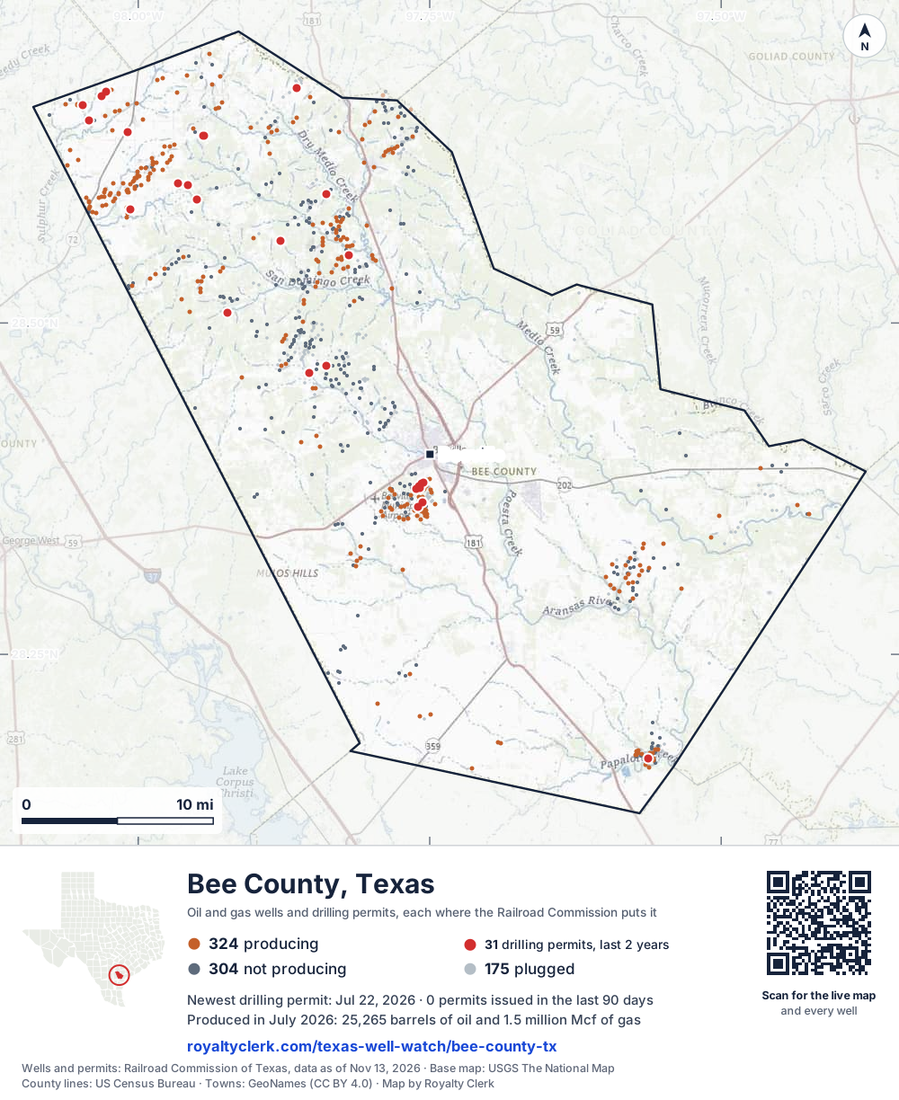
- Drilling locations31Permits issued in the last two years
- Producing wells324On a lease reporting production now
- Not producing304Shut in, inactive or no lease on record
- Plugged175The state's wellbore record says plugged
Sources: Railroad Commission of Texas well layers and permit files, US Census Bureau county outline, town points from GeoNames (CC BY 4.0), base map from USGS The National Map. A dot is a surface location; a horizontal well runs a mile or more from it.
803 wells with a location on the state's map and 31 drilling locations permitted in the last 24 months, each where the Railroad Commission puts it.
A permit is not a well.
Bee County is one of the 27 counties of the Eagle Ford Shale
Wells near each town in Bee County
Wells within 10 miles of each town, on either side of the county line.
Use this map on your site
You may show this map on any site, unchanged. Keep the credit line and its link to Royalty Clerk under the map. The picture updates by itself as the state records new wells and permits.
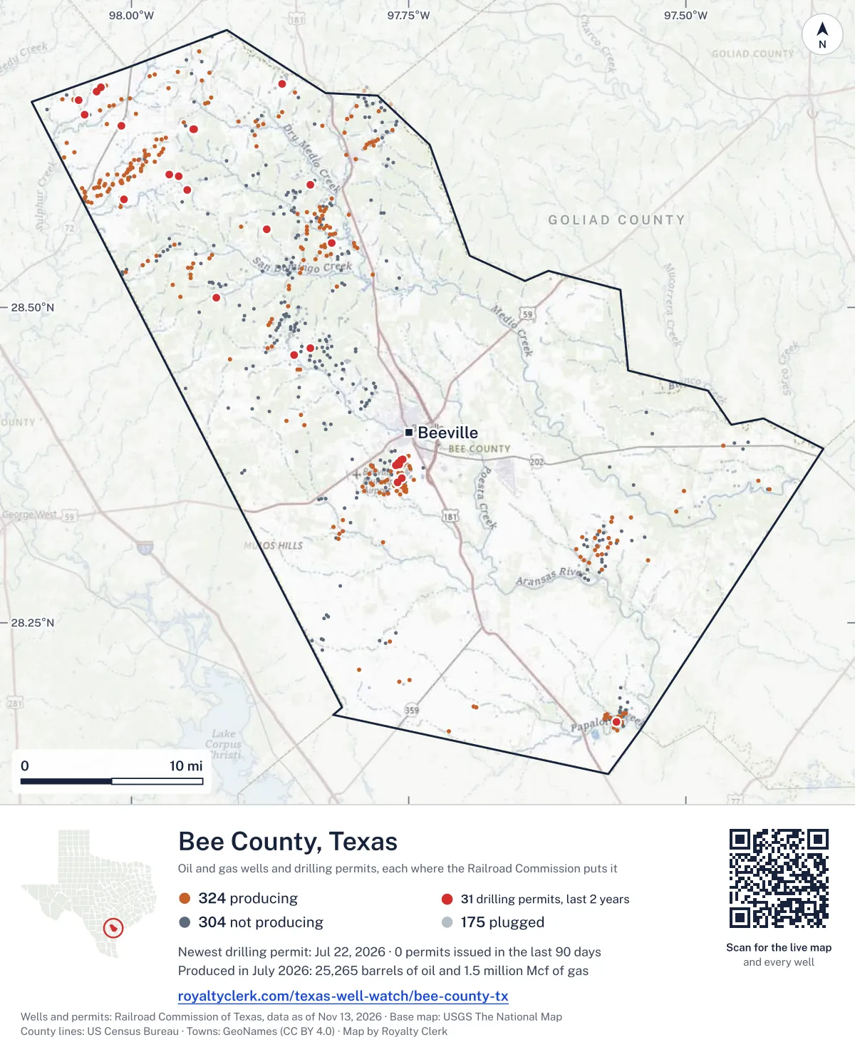
<a href="https://royaltyclerk.com/texas-well-watch/bee-county-tx"><img src="https://royaltyclerk.com/maps/county-wells/bee-county-tx.svg" alt="Map of Bee County, Texas, with 803 oil and gas wells and 31 recent drilling locations as dots." width="1000" height="1224" loading="lazy" style="max-width:100%;height:auto;border:0"></a>
<p style="margin:4px 0 0;font-size:14px">Map: <a href="https://royaltyclerk.com/texas-well-watch/bee-county-tx">Bee County, Texas oil and gas wells</a> by Royalty Clerk, from Railroad Commission of Texas records</p>
The last twelve months
Month by month in Bee County
| Month | Permits | Completions | First production |
|---|---|---|---|
| Jul 2026 | 1 | 1 | 0 |
| May 2026 | 1 | 1 | 0 |
| Apr 2026 | 2 | 0 | 0 |
| Mar 2026 | 2 | 0 | 0 |
| Feb 2026 | 0 | 2 | 1 |
| Dec 2025 | 1 | 5 | 4 |
Counted from November 16, 2025 to July 22, 2026, so the first and last months are partial. Source: Railroad Commission of Texas data sets.
Free, no sign-in
The newest drilling permits in Bee County
| Issued | Lease and well | Operator | Drilling began | Depth, ft | API number | Coordinates | Permit |
|---|---|---|---|---|---|---|---|
| 2026-07-22 | BRINKOETER 1new drill · verticalEverest Resource CompanyAPI 42-025-34087 · permit 091726828.59704, -97.838698,000 ft | Everest Resource Company | |||||
| 2026-05-22 | TAYLOR RANCH 1new drill · verticalPaloma Operating, LLCAPI 42-025-34086 · permit 091578728.59308, -97.95000drilling began 2026-06-08 · 7,600 ft | Paloma Operating, LLC | |||||
| 2026-04-27 | TEAL 1new drill · verticalSuemaur Operating LLCAPI 42-025-34085 · permit 091510628.67696, -97.8643410,000 ft | Suemaur Operating LLC | |||||
| 2026-04-08 | MIA 1new drill · verticalPaloma Operating, LLCAPI 42-025-34084 · permit 091461328.60507, -97.96610drilling began 2026-04-14 · 7,800 ft | Paloma Operating, LLC | |||||
| 2026-03-20 | SOUTH TEXAS CHILDREN'S HOME 1Trecompletion · verticalRoyal Production Company, Inc.API 42-025-34002 · permit 091421928.56215, -97.87815drilling began 2020-11-02 · 4,838 ft | Royal Production Company, Inc. | |||||
| 2026-03-19 | LYLA 1new drill · verticalPaloma Operating, LLCAPI 42-025-34083 · permit 091417128.60404, -97.95704drilling began 2026-03-30 · 7,200 ft | Paloma Operating, LLC | |||||
| 2025-12-29 | BOB WHITE 2Hnew drill · horizontalDahco Operating, LLCAPI 42-025-34082 · permit 091244328.55104, -97.819623,250 ft | Dahco Operating, LLC | |||||
| 2025-09-30 | DAVIS, NONA BERRY 76new drill · verticalWelderxp Ltd.API 42-025-34081 · permit 091079828.36125, -97.759643,900 ft | Welderxp Ltd. | |||||
| 2025-09-30 | DAVIS, NONA BERRY 75new drill · verticalWelderxp Ltd.API 42-025-34080 · permit 091079728.36448, -97.756323,950 ft | Welderxp Ltd. | |||||
| 2025-08-29 | SKY MCCARN 4Hnew drill · horizontalWarwick-Artemis, LLCAPI 42-025-34079 · permit 091004828.67101, -98.03164drilling began 2025-10-14 · 14,000 ft | Warwick-Artemis, LLC | |||||
| 2025-07-24 | MANSKER RANCH 1Rnew drill · verticalSuemaur Operating LLCAPI 42-025-34078 · permit 090942728.64120, -97.94389drilling began 2025-08-03 · 9,500 ft | Suemaur Operating LLC | |||||
| 2025-07-01 | RANCHO SALADO EAST UNIT A 1recompletion · horizontalBurlington Resources O & G Co LPAPI 42-025-33747 · permit 090897828.67471, -98.0272312,833 ft | Burlington Resources O & G Co LP | |||||
| 2025-06-30 | KAREN KENNEDY UNIT A 1recompletion · horizontalBurlington Resources O & G Co LPAPI 42-025-33794 · permit 090893828.66468, -98.04730drilling began 2012-03-14 · 13,124 ft | Burlington Resources O & G Co LP | |||||
| 2025-05-13 | MANSKER RANCH 1new drill · verticalSuemaur Operating LLCAPI 42-025-34077 · permit 090787528.64133, -97.94396drilling began 2025-06-13 · 9,500 ft | Suemaur Operating LLC | |||||
| 2025-05-08 | MURPHY, WILLIE 9Rnew drill · verticalBridwell Oil Co.API 42-025-34076 · permit 090781928.17117, -97.562844,000 ft | Bridwell Oil Co. | |||||
| 2025-03-21 | SOUTH TEXAS CHILDREN'S HOME 1Trecompletion · verticalRoyal Production Company, Inc.API 42-025-34002 · permit 090659828.56215, -97.87815drilling began 2025-02-28 · 4,838 ft | Royal Production Company, Inc. | |||||
| 2025-03-11 | KESSLER DUGAT 1new drill · verticalHeadwaters Energy Partners, LLCAPI 42-025-34075 · permit 090619428.46793, -97.838506,000 ft | Headwaters Energy Partners, LLC | |||||
| 2025-02-27 | DIANA BRALY 1new drill · verticalHeadwaters Energy Partners, LLCAPI 42-025-34064 · permit 090504228.46222, -97.85332drilling began 2025-04-12 · 6,000 ft | Headwaters Energy Partners, LLC | |||||
| 2025-02-18 | MCCARN B 3Hnew drill · horizontalWarwick-Artemis, LLCAPI 42-025-34074 · permit 090591428.65309, -98.04229drilling began 2025-03-19 · 14,000 ft | Warwick-Artemis, LLC | |||||
| 2025-02-18 | MCCARN B 2Hnew drill · horizontalWarwick-Artemis, LLCAPI 42-025-34073 · permit 090591328.65314, -98.04229drilling began 2025-03-14 · 14,000 ft | Warwick-Artemis, LLC | |||||
| 2025-02-18 | MCCARN A2 2Hnew drill · horizontalWarwick-Artemis, LLCAPI 42-025-34072 · permit 090591228.65303, -98.0422914,000 ft | Warwick-Artemis, LLC | |||||
| 2025-01-30 | RTC 3new drill · verticalPaleo Oil Company LLCAPI 42-025-34071 · permit 090554928.58600, -98.00644drilling began 2025-03-25 · 2,325 ft | Paleo Oil Company LLC | |||||
| 2025-01-14 | EDLER, J.B. 48new drill · verticalWelderxp Ltd.API 42-025-34070 · permit 090509728.37521, -97.75817drilling began 2025-03-16 · 3,850 ft | Welderxp Ltd. | |||||
| 2025-01-14 | EDLER, J.B. 47new drill · verticalWelderxp Ltd.API 42-025-34069 · permit 090509628.37460, -97.76161drilling began 2025-03-04 · 3,850 ft | Welderxp Ltd. | |||||
| 2025-01-14 | EDLER, J.B. 46new drill · verticalWelderxp Ltd.API 42-025-34068 · permit 090509528.37653, -97.75921drilling began 2025-02-21 · 3,850 ft | Welderxp Ltd. | |||||
| 2025-01-14 | EDLER, J.B. 45new drill · verticalWelderxp Ltd.API 42-025-34067 · permit 090509128.37867, -97.75683drilling began 2025-05-22 · 3,850 ft | Welderxp Ltd. | |||||
| 2025-01-14 | EDLER, J.B. 44new drill · verticalWelderxp Ltd.API 42-025-34066 · permit 090509028.37954, -97.75529drilling began 2025-01-31 · 3,850 ft | Welderxp Ltd. | |||||
| 2025-01-13 | CICADA 2Hnew drill · horizontalRosewood Resources, Inc.API 42-025-34065 · permit 090512128.64393, -98.00899drilling began 2025-06-14 · 14,000 ft | Rosewood Resources, Inc. | |||||
| 2025-01-10 | LOCUST 1Hnew drill · horizontalRosewood Resources, Inc.API 42-025-34063 · permit 090509428.64387, -98.00903drilling began 2025-06-12 · 14,000 ft | Rosewood Resources, Inc. | |||||
| 2025-01-10 | CICADA 1Hnew drill · horizontalRosewood Resources, Inc.API 42-025-34062 · permit 090509228.64398, -98.00896drilling began 2025-06-17 · 14,000 ft | Rosewood Resources, Inc. | |||||
| 2024-12-13 | H. E. YOWARD 11new drill · verticalSRS Properties, LLCAPI 42-025-34061 · permit 090465328.50769, -97.923805,500 ft | SRS Properties, LLC | |||||
| 2024-10-16 | CRUICKSHANKS 1new drill · verticalDahco Operating, LLCAPI 42-025-34059 · permit 090319428.54909, -97.93099drilling began 2024-10-28 · 3,600 ft | Dahco Operating, LLC | |||||
| 2024-10-16 | WD DUGAT 1new drill · verticalHeadwaters Energy Partners, LLCAPI 42-025-34057 · permit 090312528.46884, -97.84669drilling began 2024-11-10 · 6,000 ft | Headwaters Energy Partners, LLC | |||||
| 2024-10-14 | BOB WHITE 1Hnew drill · horizontalDahco Operating, LLCAPI 42-025-34060 · permit 090319628.56356, -97.82071drilling began 2024-11-22 · 3,250 ft | Dahco Operating, LLC | |||||
| 2024-10-11 | MCWHORTER HEIRS 1new drill · verticalPaloma Operating, LLCAPI 42-025-34058 · permit 090319028.57919, -97.76977drilling began 2025-02-05 · 5,000 ft | Paloma Operating, LLC | |||||
| 2024-07-10 | EVANS BROS 3new drill · verticalWelderxp Ltd.API 42-025-34056 · permit 090099528.37860, -97.748753,900 ft | Welderxp Ltd. | |||||
| 2024-07-09 | EVANS BROS 2new drill · verticalWelderxp Ltd.API 42-025-34055 · permit 090099428.38041, -97.75380drilling began 2024-08-20 · 3,900 ft | Welderxp Ltd. | |||||
| 2024-07-09 | EVANS BROS 1new drill · verticalWelderxp Ltd.API 42-025-34054 · permit 090099328.38145, -97.75266drilling began 2024-08-12 · 3,900 ft | Welderxp Ltd. | |||||
| 2024-06-11 | BREVARD 1new drill · verticalKebo Oil & Gas, Inc.API 42-025-34053 · permit 090026028.57918, -98.017386,480 ft | Kebo Oil & Gas, Inc. | |||||
| 2024-05-31 | RTC 4re-entry · verticalPaleo Oil Company LLCAPI 42-025-31944 · permit 090006428.58364, -98.00589drilling began 2024-06-10 · 6,212 ft | Paleo Oil Company LLC | |||||
| 2024-03-25 | DAVIS, NONA BERRY 74new drill · verticalWelderxp Ltd.API 42-025-34052 · permit 089834928.36162, -97.75754drilling began 2024-04-22 · 3,950 ft | Welderxp Ltd. | |||||
| 2024-02-02 | RTC 2new drill · verticalPaleo Oil Company LLCAPI 42-025-34025 · permit 088404328.58549, -98.00699drilling began 2024-02-23 · 6,500 ft | Paleo Oil Company LLC | |||||
| 2023-12-20 | HENKHAUS 1new drill · verticalKebo Oil & Gas, Inc.API 42-025-34051 · permit 089607928.38632, -97.40435drilling began 2023-12-31 · 5,600 ft | Kebo Oil & Gas, Inc. | |||||
| 2023-12-14 | WINDHAM A 5Hnew drill · horizontalWarwick-Artemis, LLCAPI 42-025-34050 · permit 089538828.66495, -98.06260drilling began 2024-03-11 · 14,000 ft | Warwick-Artemis, LLC | |||||
| 2023-12-05 | BUMBLE BEE B E 1LHnew drill · horizontalWarwick-Artemis, LLCAPI 42-025-34045 · permit 089480828.68464, -97.9789013,000 ft | Warwick-Artemis, LLC | |||||
| 2023-12-01 | WINDHAM A 4Hnew drill · horizontalWarwick-Artemis, LLCAPI 42-025-34049 · permit 089538728.66501, -98.06260drilling began 2024-03-13 · 14,000 ft | Warwick-Artemis, LLC | |||||
| 2023-12-01 | WINDHAM A 3Hnew drill · horizontalWarwick-Artemis, LLCAPI 42-025-34048 · permit 089538628.66506, -98.06260drilling began 2024-03-16 · 14,000 ft | Warwick-Artemis, LLC | |||||
| 2023-12-01 | WINDHAM A 2Hnew drill · horizontalWarwick-Artemis, LLCAPI 42-025-34047 · permit 089538528.66512, -98.06260drilling began 2024-03-19 · 14,000 ft | Warwick-Artemis, LLC | |||||
| 2023-11-07 | COX-HISLOP G.U. 1new drill · verticalWelderxp Ltd.API 42-025-34046 · permit 089493628.52563, -97.880088,600 ft | Welderxp Ltd. | |||||
| 2023-10-26 | BUMBLE BEE B 3LHnew drill · horizontalWarwick-Artemis, LLCAPI 42-025-34044 · permit 089477828.68443, -97.97890drilling began 2023-10-30 · 13,000 ft | Warwick-Artemis, LLC |
These are the newest 50 of 53 permits on file for Bee County. The rest follow, 50 to a page.
A permit is permission to drill, not a well. Source: Railroad Commission of Texas drilling permit files.
Year by year
Drilling permits issued in Bee County, by year
| Year | Permits issued |
|---|---|
| 2026 so far | 6 |
| 2025 | 24 |
| 2024 | 12 |
| 2023 | 11 |
Counted from the permit files we hold, which start in 2023; that first year may be partial. Source: Railroad Commission of Texas drilling permit files.
The latest
The most recent records
| Date | What, who and where |
|---|---|
| 2026-07-22 | Permit issued: Everest Resource CompanyBRINKOETER · A-411 · permit 0917268 |
| 2026-07-20 | Completed: Suemaur Operating LLCTEAL · A-315 · permit 0915106 |
| 2026-05-22 | Permit issued: Paloma Operating, LLCTAYLOR RANCH · A-114 · permit 0915787 |
| 2026-05-06 | Completed: Welderxp Ltd.EDLER, J.B. · A-139 · permit 0905090 |
| 2026-04-27 | Permit issued: Suemaur Operating LLCTEAL · A-315 · permit 0915106 |
| 2026-04-08 | Permit issued: Paloma Operating, LLCMIA · A-453 · permit 0914613 |
| 2026-03-20 | Permit issued: Royal Production Company, Inc.SOUTH TEXAS CHILDREN'S HOME · A-532 · permit 0914219 |
| 2026-03-19 | Permit issued: Paloma Operating, LLCLYLA · A-550 · permit 0914171 |
| 2026-02-25 | Completed: Lakeshore Operating, LLCHEARD, C.E. -B- · A-67 |
| 2026-02-20 | Completed: Royal Production Company, Inc.SOUTH TEXAS CHILDREN'S HOME · A-532 · permit 0914219 |
| 2026-02-01 | First production: Royal Production Company, Inc.South Texas Children's Home |
| 2025-12-30 | Completed: Rosewood Resources, Inc.LOCUST · A-70 · permit 0905094 |
| 2025-12-30 | Completed: Rosewood Resources, Inc.CICADA · A-70 · permit 0905121 |
| 2025-12-30 | Completed: Rosewood Resources, Inc.CICADA · A-70 · permit 0905092 |
| 2025-12-29 | Permit issued: Dahco Operating, LLCBOB WHITE · A-68 · permit 0912443 |
Follow it
Watch Bee County, or one abstract
What do you want to follow?
Where the land is. Your deed or lease names it.
For example A-1119, or Bush, or T&P 38. Your deed or the tax bill has it.
Other counties
Drilling activity in other counties
Related
Related
- ToolTexas well watchPermit, completion, first production and when the first check is due.
- ToolIs this buyout offer fair?The offer as months of your income, what the acres mean, and the questions to ask.
- ToolIs this lease offer good?Bonus and royalty against the county, and a scan of the lease's clauses.
- Texas dataTexas operator changesWho took over whose leases in the last 24 months.
- ToolLate payment interestDeadlines and the interest a late payment earns.
- Texas dataTexas oil and gas atlas254 counties, every lease, operator and field.
FAQ
Questions people ask
How many wells were permitted in Bee County in the last year?
The Railroad Commission issued 7 drilling permits in Bee County in the twelve months to July 22, 2026, and recorded 9 completions and 5 first-production reports. A permit is permission to drill, not a well.
How do I get an alert when a permit is issued near my land in Bee County?
Choose your abstract on this page, or the whole county, and sign in. You get one email a week, only when something new is recorded after you sign up. The alert says whether an event is on an interest in your Mineral File, on a place you follow, or only nearby.
When is my first royalty check due after a new well?
Natural Resources Code section 91.402(a) says on or before 120 days after the end of the month of first sale of production from the well. The state's first-production month is the closest public marker, so the date on this page is the earliest, not a certainty.
Got a new well on your land?
The first check is due within 120 days after the end of the month of first sale.
Sources
Primary sources, opened on 29 September 2026. Statute text is the current version on statutes.capitol.texas.gov.