
Railroad Commission of Texas · Districts 1 to 6 · 27 counties
Eagle Ford Shale
- 1,565drilling permits in 12 months
- 19%of the state's permits
- 59,620wells on the map
- 109operators filing
Where it is drilled
The Eagle Ford Shale's wells and new permits
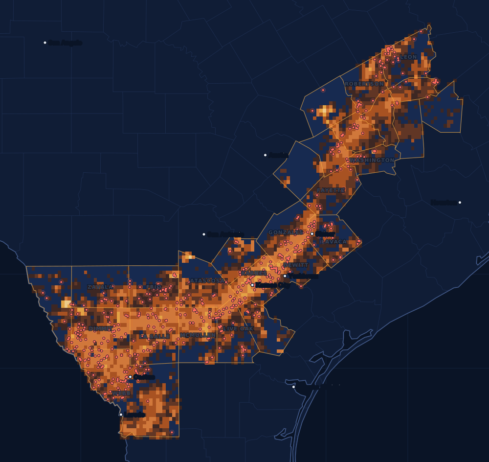
A shale that runs from the Mexican border into East Texas, about 50 miles wide and 400 miles long and some 250 feet thick. It gives gas, and more oil than most shale plays.
Counties
The 27 counties, by permits
Drilling permits of the last 12 months in each county, and the wells on the state's map there. Each county's live map shows every well and permit where the state puts it.
- 1Webb County2738,339 wells on the mapLive map
- 2De Witt County1743,123 wells on the mapLive map
- 3Karnes County1536,140 wells on the mapLive map
- 4Dimmit County1535,752 wells on the mapLive map
- 5La Salle County1215,246 wells on the mapLive map
- 6McMullen County964,079 wells on the mapLive map
- 7Live Oak County821,845 wells on the mapLive map
- 8Gonzales County732,481 wells on the mapLive map
- 9Frio County731,768 wells on the mapLive map
- 10Atascosa County583,129 wells on the mapLive map
- 11Washington County47588 wells on the mapLive map
- 12Lavaca County461,048 wells on the mapLive map
- 13Fayette County381,051 wells on the mapLive map
- 14Leon County301,165 wells on the mapLive map
- 15Robertson County221,305 wells on the mapLive map
- 16Zavala County22939 wells on the mapLive map
The other 11 counties, A to Z
- Bastrop County0 permits · 367 wells
- Bee County7 permits · 803 wells
- Brazos County3 permits · 1,133 wells
- Burleson County17 permits · 1,837 wells
- Grimes County1 permits · 312 wells
- Lee County20 permits · 1,084 wells
- Madison County12 permits · 738 wells
- Maverick County21 permits · 2,010 wells
- Milam County2 permits · 2,260 wells
- Walker County1 permits · 60 wells
- Wilson County20 permits · 1,018 wells
Operators
Who files the permits
The companies with the most drilling permits in the play's counties in the last 12 months, as the state names them.
- 1EOG Resources, Inc.169
- 2Burlington Resources O & G Co LP162
- 3Magnolia Oil & Gas Operating LLC84
- 4Rosewood Resources, Inc.57
- 5Devon Energy Production Co, L.P.56
- 6Marathon Oil Ef LLC55
- 7Javelin Energy Partners Mgmt LLC54
- 8Lewis Petro Properties, Inc.54
- 9BPX Operating Company53
- 10Caturus Energy, LLC53
- 11Verdun Oil & Gas LLC45
- 12Silver Hill Energy Operating LLC43
Wells completed each year
Most in 2014: 4,923. 2025: 1,248. 2026 so far, lighter.
Towns with the most permits nearby
Drilling permits of the last 12 months within 10 miles of the town.
FAQ
Questions people ask
Is my land in the Eagle Ford?
This page counts every well and permit in the 27 counties the Railroad Commission lists for the Eagle Ford Shale. A county on the list does not mean the formation lies under every tract in it, or that a well will be drilled on yours. Your county's live map shows the wells and permits around your land, and the operator's division order says which well pays you.
What does the heat on the map show?
Every well on the state's map, counted in squares about two and a half miles wide: the brighter the square, the more wells in it. It shows where drilling has been, old wells included. The red dots are the drilling permits of the last twelve months that have a location on file: where drilling is going now.
Why are some years so different?
Drilling follows prices and the industry's spending. The bars count wells by the completion date the state has on file; the newest months fill in as operators file their completion reports, so the current year is drawn lighter.
Does a permit mean royalties?
No. A permit is permission to drill, not a well, and many are drilled months later or never. Royalties start after a well is completed, produces and the operator sets up its division order. If you own minerals in one of these counties, the first check is usually due about four months after first sales.
Sources
- Railroad Commission of Texas, Eagle Ford Shale (the play and its affected counties)www.rrc.texas.gov/oil-and-gas/major-oil-and-gas-formations/eagle-ford-shale/ · read November 14, 2026
- Railroad Commission of Texas, major oil and gas formationswww.rrc.texas.gov/oil-and-gas/major-oil-and-gas-formations/ · read November 14, 2026
- Railroad Commission of Texas, well layers, completion records and drilling permit fileswww.rrc.texas.gov/resource-center/research/data-sets-available-for-download/ · loaded as the state publishes them; figures kept six hours
- US Census Bureau, cartographic boundary files (county lines), through the us-atlas package 3.0.1www.census.gov/geographies/mapping-files/time-series/geo/cartographic-boundary.html · built into the site with its well maps
- GeoNames, towns and their points (CC BY 4.0)www.geonames.org/ · built into the site with its town pages