
Burleson County, Texas
Burleson County drilling permits: what the state recorded
- 17drilling permits
- 26completions
- 8first-production reports
- in the last twelve months
Wells by coordinates
Oil wells and drilling locations in Burleson County
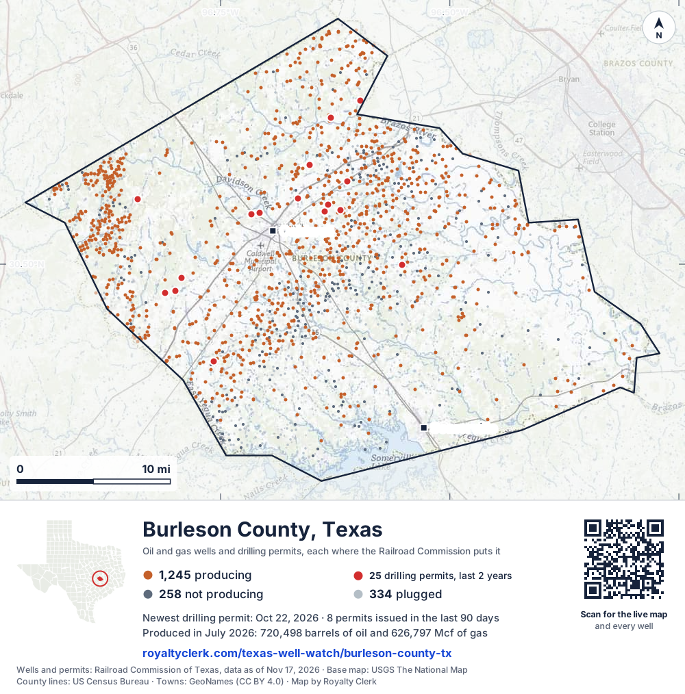
- Drilling locations25Permits issued in the last two years
- Producing wells1,245On a lease reporting production now
- Not producing258Shut in, inactive or no lease on record
- Plugged334The state's wellbore record says plugged
Sources: Railroad Commission of Texas well layers and permit files, US Census Bureau county outline, town points from GeoNames (CC BY 4.0), base map from USGS The National Map. A dot is a surface location; a horizontal well runs a mile or more from it.
1,837 wells with a location on the state's map and 25 drilling locations permitted in the last 24 months, each where the Railroad Commission puts it.
A permit is not a well.
Burleson County is one of the 27 counties of the Eagle Ford Shale
Wells near each town in Burleson County
Wells within 10 miles of each town, on either side of the county line.
Use this map on your site
You may show this map on any site, unchanged. Keep the credit line and its link to Royalty Clerk under the map. The picture updates by itself as the state records new wells and permits.
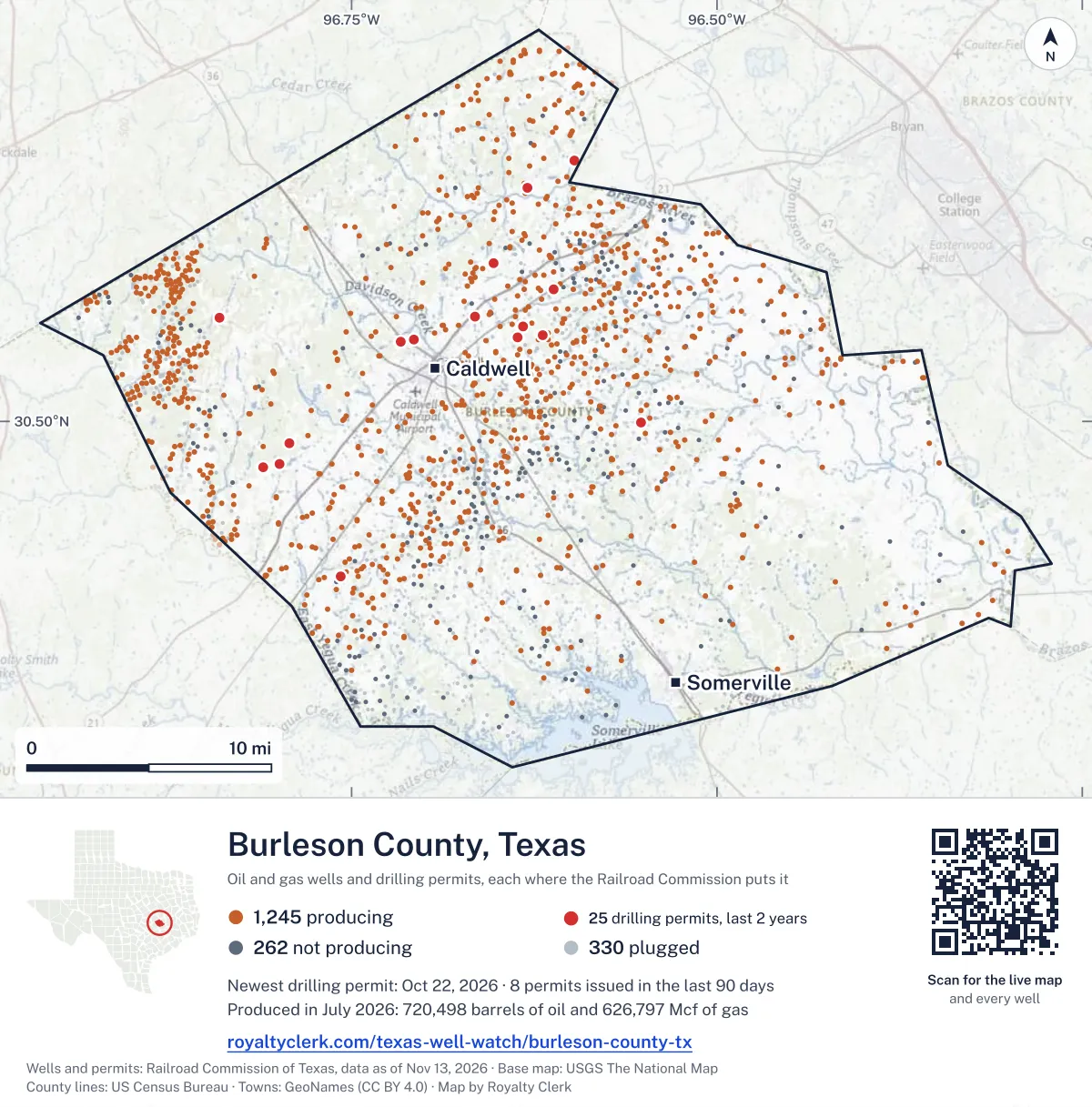
<a href="https://royaltyclerk.com/texas-well-watch/burleson-county-tx"><img src="https://royaltyclerk.com/maps/county-wells/burleson-county-tx.svg" alt="Map of Burleson County, Texas, with 1,837 oil and gas wells and 25 recent drilling locations as dots." width="1000" height="1014" loading="lazy" style="max-width:100%;height:auto;border:0"></a>
<p style="margin:4px 0 0;font-size:14px">Map: <a href="https://royaltyclerk.com/texas-well-watch/burleson-county-tx">Burleson County, Texas oil and gas wells</a> by Royalty Clerk, from Railroad Commission of Texas records</p>
The last twelve months
Month by month in Burleson County
| Month | Permits | Completions | First production |
|---|---|---|---|
| Oct 2026 | 5 | 1 | 0 |
| Sep 2026 | 3 | 0 | 0 |
| Jul 2026 | 2 | 3 | 0 |
| Jun 2026 | 0 | 5 | 0 |
| May 2026 | 4 | 9 | 5 |
| Apr 2026 | 2 | 1 | 0 |
| Mar 2026 | 0 | 4 | 1 |
| Feb 2026 | 0 | 2 | 2 |
| Jan 2026 | 0 | 1 | 0 |
| Dec 2025 | 1 | 0 | 0 |
Counted from November 19, 2025 to October 22, 2026, so the first and last months are partial. Source: Railroad Commission of Texas data sets.
Free, no sign-in
The newest drilling permits in Burleson County
| Issued | Lease and well | Operator | Drilling began | Depth, ft | API number | Coordinates | Permit |
|---|---|---|---|---|---|---|---|
| 2026-10-22 | CHARLOTTE NICOLE A 1HEnew drill · horizontalMagnolia Oil & Gas Operating LLCAPI 42-051-34431 · permit 091936930.55609, -96.632758,500 ft | Magnolia Oil & Gas Operating LLC | |||||
| 2026-10-20 | STEFKA EF UNIT H 01SMnew drill · horizontalMagnolia Oil & Gas Operating LLCAPI 42-051-34428 · permit 091927130.56199, -96.665287,600 ft | Magnolia Oil & Gas Operating LLC | |||||
| 2026-10-15 | MUTT EF UNIT H 05SMnew drill · horizontalMagnolia Oil & Gas Operating LLCAPI 42-051-34429 · permit 091927530.56206, -96.665387,600 ft | Magnolia Oil & Gas Operating LLC | |||||
| 2026-10-15 | KELLY EF UNIT H 03SMnew drill · horizontalMagnolia Oil & Gas Operating LLCAPI 42-051-34430 · permit 091927630.56203, -96.665337,600 ft | Magnolia Oil & Gas Operating LLC | |||||
| 2026-10-15 | DENNIS RAY A 1HEnew drill · horizontalMagnolia Oil & Gas Operating LLCAPI 42-051-34424 · permit 091845430.55603, -96.632698,500 ft | Magnolia Oil & Gas Operating LLC | |||||
| 2026-09-24 | ASCARI ALLOC. 2HEnew drill · horizontalMagnolia Oil & Gas Operating LLCAPI 42-051-34426 · permit 091870230.59343, -96.653077,600 ft | Magnolia Oil & Gas Operating LLC | |||||
| 2026-09-23 | ASCARI UNIT 3HEnew drill · horizontalMagnolia Oil & Gas Operating LLCAPI 42-051-34425 · permit 091870130.59340, -96.653137,600 ft | Magnolia Oil & Gas Operating LLC | |||||
| 2026-09-22 | BRECK EF UNIT 3HEnew drill · horizontalMagnolia Oil & Gas Operating LLCAPI 42-051-34427 · permit 091878630.59337, -96.653177,600 ft | Magnolia Oil & Gas Operating LLC | |||||
| 2026-07-06 | FAIRWAY B 13HAnew drill · horizontalWildfire Energy Operating LLCAPI 42-051-34422 · permit 091683030.57788, -96.611449,000 ft | Wildfire Energy Operating LLC | |||||
| 2026-07-06 | FAIRWAY A 11HAnew drill · horizontalWildfire Energy Operating LLCAPI 42-051-34421 · permit 091682930.55076, -96.619259,000 ft | Wildfire Energy Operating LLC | |||||
| 2026-05-18 | SUNRISE 1HEnew drill · horizontalWildfire Energy Operating LLCAPI 42-051-34420 · permit 091557930.47482, -96.799158,000 ft | Wildfire Energy Operating LLC | |||||
| 2026-05-14 | REED EF UNIT 2Hnew drill · horizontalWildfire Energy Operating LLCAPI 42-051-34419 · permit 091552530.48695, -96.79264drilling began 2026-06-10 · 8,000 ft | Wildfire Energy Operating LLC | |||||
| 2026-05-13 | KRETZER 1Hnew drill · horizontalWildfire Energy Operating LLCAPI 42-051-34418 · permit 091551430.48699, -96.79256drilling began 2026-06-09 · 8,000 ft | Wildfire Energy Operating LLC | |||||
| 2026-05-01 | L8-9-4-9 1new drill · verticalAtmos Pipeline - TexasAPI 42-051-34417 · permit 091441430.49958, -96.55165550 ft | Atmos Pipeline - Texas | |||||
| 2026-04-28 | SCHAPER HCX1 1Hnew drill · horizontalWildfire Energy Operating LLCAPI 42-051-34416 · permit 091508930.47308, -96.81043drilling began 2026-06-06 · 8,000 ft | Wildfire Energy Operating LLC | |||||
| 2026-04-23 | SORSBY HCX 2Hnew drill · horizontalWildfire Energy Operating LLCAPI 42-051-34415 · permit 091501930.47304, -96.810518,000 ft | Wildfire Energy Operating LLC | |||||
| 2025-12-16 | FOX 4HEnew drill · horizontalWildfire Energy Operating LLCAPI 42-051-34412 · permit 091064230.54849, -96.70774drilling began 2026-03-17 · 8,000 ft | Wildfire Energy Operating LLC | |||||
| 2025-10-27 | MARY AGNES 1HEnew drill · horizontalWildfire Energy Operating LLCAPI 42-051-34414 · permit 091064530.54690, -96.71610drilling began 2026-02-16 · 8,000 ft | Wildfire Energy Operating LLC | |||||
| 2025-10-23 | MARY AGNES HCX 2HEnew drill · horizontalWildfire Energy Operating LLCAPI 42-051-34413 · permit 091064430.54683, -96.71604drilling began 2026-02-17 · 8,000 ft | Wildfire Energy Operating LLC | |||||
| 2025-06-16 | JUSTICE 8HAnew drill · horizontalWildfire Energy Operating LLCAPI 42-051-34411 · permit 090857930.65387, -96.59751drilling began 2026-01-30 · 8,000 ft | Wildfire Energy Operating LLC | |||||
| 2025-05-07 | BIG LEE HCX 1HAnew drill · horizontalWildfire Energy Operating LLCAPI 42-051-34410 · permit 090774030.63791, -96.62960drilling began 2025-06-23 · 8,000 ft | Wildfire Energy Operating LLC | |||||
| 2025-04-22 | FAIRWAY 5HAnew drill · horizontalWildfire Energy Operating LLCAPI 42-051-34409 · permit 090750530.54929, -96.63631drilling began 2026-01-11 · 8,500 ft | Wildfire Energy Operating LLC | |||||
| 2025-04-11 | C.L. ANDERSON A HCX 1Hnew drill · horizontalWildfire Energy Operating LLCAPI 42-051-34408 · permit 090730730.40854, -96.75767drilling began 2026-04-03 · 9,000 ft | Wildfire Energy Operating LLC | |||||
| 2025-04-11 | GRW 1new drill · verticalStrand Energy, L.c.API 42-051-34407 · permit 090729830.56124, -96.840129,900 ft | Strand Energy, L.c. | |||||
| 2024-12-18 | C.L. ANDERSON B 1Hnew drill · horizontalWildfire Energy Operating LLCAPI 42-051-34405 · permit 090476830.40860, -96.75761drilling began 2026-04-04 · 9,000 ft | Wildfire Energy Operating LLC | |||||
| 2024-11-04 | TUCKER HCX1 2HEnew drill · horizontalWildfire Energy Operating LLCAPI 42-051-34404 · permit 090285730.50632, -96.77771drilling began 2024-11-14 · 8,500 ft | Wildfire Energy Operating LLC | |||||
| 2024-11-04 | TUCKER 1HEnew drill · horizontalWildfire Energy Operating LLCAPI 42-051-34402 · permit 090285630.50625, -96.77785drilling began 2024-11-11 · 8,500 ft | Wildfire Energy Operating LLC | |||||
| 2024-11-04 | CORBIN HCX1 2HEnew drill · horizontalWildfire Energy Operating LLCAPI 42-051-34401 · permit 090285430.50629, -96.77778drilling began 2024-11-12 · 8,500 ft | Wildfire Energy Operating LLC | |||||
| 2024-10-25 | CORBIN HCX2 3HEnew drill · horizontalWildfire Energy Operating LLCAPI 42-051-34403 · permit 090285530.50622, -96.77792drilling began 2024-11-10 · 8,500 ft | Wildfire Energy Operating LLC | |||||
| 2024-09-23 | SULLY ALLOC. 1HEnew drill · horizontalWildfire Energy Operating LLCAPI 42-051-34398 · permit 090268230.57928, -96.60352drilling began 2026-04-16 · 8,500 ft | Wildfire Energy Operating LLC | |||||
| 2024-09-19 | HARLEY UNIT 1HEnew drill · horizontalWildfire Energy Operating LLCAPI 42-051-34400 · permit 090269530.56788, -96.57300drilling began 2026-05-07 · 8,500 ft | Wildfire Energy Operating LLC | |||||
| 2024-09-19 | SULLY UNIT 2HEnew drill · horizontalWildfire Energy Operating LLCAPI 42-051-34399 · permit 090268330.56783, -96.57307drilling began 2026-05-06 · 8,500 ft | Wildfire Energy Operating LLC | |||||
| 2024-09-11 | RILEY 1HEnew drill · horizontalWildfire Energy Operating LLCAPI 42-051-34397 · permit 090255730.57934, -96.603588,500 ft | Wildfire Energy Operating LLC | |||||
| 2024-09-11 | ROSS 1HEnew drill · horizontalWildfire Energy Operating LLCAPI 42-051-34396 · permit 090255230.57922, -96.60347drilling began 2026-04-14 · 8,500 ft | Wildfire Energy Operating LLC | |||||
| 2024-09-11 | CHARANZA 1 Creclass · verticalOgden Resources CorporationAPI 42-051-31060 · permit 089817630.39003, -96.63499drilling began 2019-06-03 · 9,321 ft | Ogden Resources Corporation | |||||
| 2024-07-23 | NOVOSAD HCX1 1Hnew drill · horizontalWildfire Energy Operating LLCAPI 42-051-34395 · permit 090127230.53640, -96.75965drilling began 2024-09-20 · 9,000 ft | Wildfire Energy Operating LLC | |||||
| 2024-07-23 | HOLLIDAY HCX6 A 6Hnew drill · horizontalWildfire Energy Operating LLCAPI 42-051-34394 · permit 090126930.53633, -96.75960drilling began 2024-09-19 · 9,000 ft | Wildfire Energy Operating LLC | |||||
| 2024-03-12 | JACKSON 2Hnew drill · horizontalSBJ Energy Partners, L.L.C.API 42-051-34393 · permit 089783230.54654, -96.8613712,000 ft | SBJ Energy Partners, L.L.C. | |||||
| 2023-10-05 | JACKSON 1Hnew drill · horizontalSBJ Energy Partners, L.L.C.API 42-051-34391 · permit 089423330.54729, -96.8613512,000 ft | SBJ Energy Partners, L.L.C. | |||||
| 2023-08-14 | HORAK B 1Hnew drill · horizontalWildfire Energy Operating LLCAPI 42-051-34388 · permit 089270130.40652, -96.77263drilling began 2024-06-19 · 9,000 ft | Wildfire Energy Operating LLC | |||||
| 2023-04-26 | GUNSMITH ALLOC. 1Hnew drill · horizontalWildfire Energy Operating LLCAPI 42-051-34386 · permit 088987730.51039, -96.805438,000 ft | Wildfire Energy Operating LLC | |||||
| 2023-04-21 | DUSK 2Hnew drill · horizontalWildfire Energy Operating LLCAPI 42-051-34385 · permit 088987130.51032, -96.80548drilling began 2023-11-14 · 8,000 ft | Wildfire Energy Operating LLC | |||||
| 2023-01-17 | RUSSELL TRUST B 3Hnew drill · horizontalTrailblazer Energy Resources,llcAPI 42-051-34382 · permit 088674730.51969, -96.81544drilling began 2023-02-18 · 6,700 ft | Trailblazer Energy Resources,llc | |||||
| 2022-03-01 | BLACK ALLOCATION 2Hnew drill · horizontalWildfire Energy Operating LLCAPI 42-051-34369 · permit 087732530.47273, -96.64668drilling began 2022-09-18 · 9,000 ft | Wildfire Energy Operating LLC | |||||
| 2022-02-28 | BLACK 1Hnew drill · horizontalWildfire Energy Operating LLCAPI 42-051-34368 · permit 087731430.47279, -96.64675drilling began 2022-09-17 · 9,000 ft | Wildfire Energy Operating LLC | |||||
| 2022-02-18 | SPARROW ALLOCATION 1Hnew drill · horizontalWildfire Energy Operating LLCAPI 42-051-34366 · permit 087712230.47267, -96.64661drilling began 2022-09-19 · 9,000 ft | Wildfire Energy Operating LLC |
A permit is permission to drill, not a well. Source: Railroad Commission of Texas drilling permit files.
Year by year
Drilling permits issued in Burleson County, by year
| Year | Permits issued |
|---|---|
| 2026 so far | 16 |
| 2025 | 8 |
| 2024 | 14 |
| 2023 | 5 |
| 2022 | 3 |
Counted from the permit files we hold, which start in 2022; that first year may be partial. Source: Railroad Commission of Texas drilling permit files.
The latest
The most recent records
| Date | What, who and where |
|---|---|
| 2026-10-22 | Permit issued: Magnolia Oil & Gas Operating LLCCHARLOTTE NICOLE A · A-48 · permit 0919369 |
| 2026-10-20 | Permit issued: Magnolia Oil & Gas Operating LLCSTEFKA EF UNIT · A-28 · permit 0919271 |
| 2026-10-15 | Permit issued: Magnolia Oil & Gas Operating LLCDENNIS RAY A · A-48 · permit 0918454 |
| 2026-10-15 | Permit issued: Magnolia Oil & Gas Operating LLCMUTT EF UNIT · A-28 · permit 0919275 |
| 2026-10-15 | Permit issued: Magnolia Oil & Gas Operating LLCKELLY EF UNIT · A-28 · permit 0919276 |
| 2026-10-08 | Completed: Wildfire Energy Operating LLCFAIRWAY B · A-34 · permit 0916830 |
| 2026-09-24 | Permit issued: Magnolia Oil & Gas Operating LLCASCARI ALLOC. · A-213 · permit 0918702 |
| 2026-09-23 | Permit issued: Magnolia Oil & Gas Operating LLCASCARI UNIT · A-213 · permit 0918701 |
| 2026-09-22 | Permit issued: Magnolia Oil & Gas Operating LLCBRECK EF UNIT · A-213 · permit 0918786 |
| 2026-07-25 | Completed: Wildfire Energy Operating LLCSULLY UNIT · A-34 · permit 0902683 |
| 2026-07-24 | Completed: Wildfire Energy Operating LLCSULLY ALLOC. · A-34 · permit 0902682 |
| 2026-07-18 | Completed: Wildfire Energy Operating LLCSUNRISE · A-203 · permit 0915579 |
| 2026-07-06 | Permit issued: Wildfire Energy Operating LLCFAIRWAY B · A-34 · permit 0916830 |
| 2026-07-06 | Permit issued: Wildfire Energy Operating LLCFAIRWAY A · A-48 · permit 0916829 |
| 2026-06-30 | Completed: Wildfire Energy Operating LLCREED EF UNIT · A-95 · permit 0915525 |
Follow it
Watch Burleson County, or one abstract
What do you want to follow?
Where the land is. Your deed or lease names it.
For example A-1119, or Bush, or T&P 38. Your deed or the tax bill has it.
Other counties
Drilling activity in other counties
Related
Related
- ToolTexas well watchPermit, completion, first production and when the first check is due.
- ToolIs this buyout offer fair?The offer as months of your income, what the acres mean, and the questions to ask.
- ToolIs this lease offer good?Bonus and royalty against the county, and a scan of the lease's clauses.
- Texas dataTexas operator changesWho took over whose leases in the last 24 months.
- ToolLate payment interestDeadlines and the interest a late payment earns.
- Texas dataTexas oil and gas atlas254 counties, every lease, operator and field.
FAQ
Questions people ask
How many wells were permitted in Burleson County in the last year?
The Railroad Commission issued 17 drilling permits in Burleson County in the twelve months to October 22, 2026, and recorded 26 completions and 8 first-production reports. A permit is permission to drill, not a well.
How do I get an alert when a permit is issued near my land in Burleson County?
Choose your abstract on this page, or the whole county, and sign in. You get one email a week, only when something new is recorded after you sign up. The alert says whether an event is on an interest in your Mineral File, on a place you follow, or only nearby.
When is my first royalty check due after a new well?
Natural Resources Code section 91.402(a) says on or before 120 days after the end of the month of first sale of production from the well. The state's first-production month is the closest public marker, so the date on this page is the earliest, not a certainty.
Got a new well on your land?
The first check is due within 120 days after the end of the month of first sale.
Sources
Primary sources, opened on 29 September 2026. Statute text is the current version on statutes.capitol.texas.gov.