
Cass County, Texas
Cass County drilling permits: what the state recorded
- 13drilling permits
- 2completions
- 0first-production reports
- in the last twelve months
Wells by coordinates
Oil wells and drilling locations in Cass County
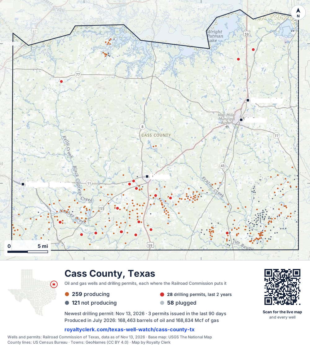
- Drilling locations28Permits issued in the last two years
- Producing wells259On a lease reporting production now
- Not producing121Shut in, inactive or no lease on record
- Plugged58The state's wellbore record says plugged
Sources: Railroad Commission of Texas well layers and permit files, US Census Bureau county outline, town points from GeoNames (CC BY 4.0), base map from USGS The National Map. A dot is a surface location; a horizontal well runs a mile or more from it.
438 wells with a location on the state's map and 28 drilling locations permitted in the last 24 months, each where the Railroad Commission puts it.
A permit is not a well.
Wells near each town in Cass County
Wells within 10 miles of each town, on either side of the county line.
Use this map on your site
You may show this map on any site, unchanged. Keep the credit line and its link to Royalty Clerk under the map. The picture updates by itself as the state records new wells and permits.
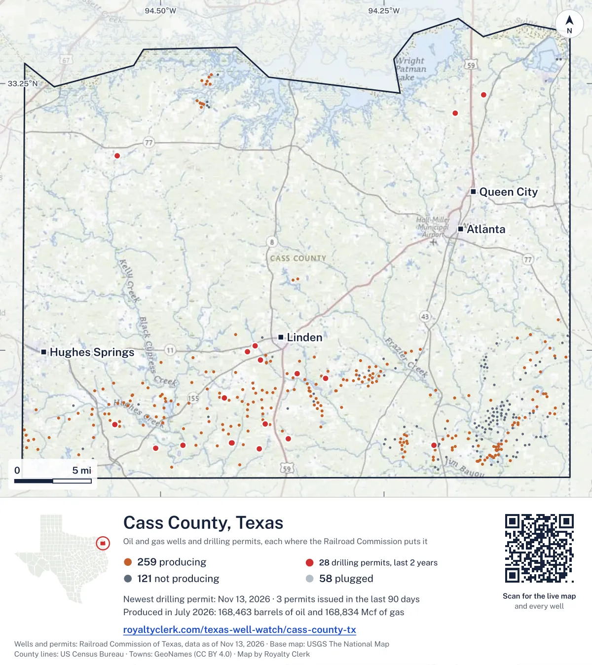
<a href="https://royaltyclerk.com/texas-well-watch/cass-county-tx"><img src="https://royaltyclerk.com/maps/county-wells/cass-county-tx.svg" alt="Map of Cass County, Texas, with 438 oil and gas wells and 28 recent drilling locations as dots." width="1000" height="1123" loading="lazy" style="max-width:100%;height:auto;border:0"></a>
<p style="margin:4px 0 0;font-size:14px">Map: <a href="https://royaltyclerk.com/texas-well-watch/cass-county-tx">Cass County, Texas oil and gas wells</a> by Royalty Clerk, from Railroad Commission of Texas records</p>
The last twelve months
Month by month in Cass County
| Month | Permits | Completions | First production |
|---|---|---|---|
| Nov 2026 | 1 | 0 | 0 |
| Oct 2026 | 1 | 0 | 0 |
| Aug 2026 | 1 | 0 | 0 |
| Jul 2026 | 3 | 0 | 0 |
| Jun 2026 | 1 | 0 | 0 |
| May 2026 | 3 | 0 | 0 |
| Apr 2026 | 0 | 1 | 0 |
| Mar 2026 | 1 | 0 | 0 |
| Feb 2026 | 1 | 0 | 0 |
| Dec 2025 | 1 | 0 | 0 |
| Nov 2025 | 0 | 1 | 0 |
Counted from November 15, 2025 to November 13, 2026, so the first and last months are partial. Source: Railroad Commission of Texas data sets.
Free, no sign-in
The newest drilling permits in Cass County
| Issued | Lease and well | Operator | Drilling began | Depth, ft | API number | Coordinates | Permit |
|---|---|---|---|---|---|---|---|
| 2026-11-13 | SALMON 1Hnew drill · horizontalRose City Resources, LLCAPI 42-067-30989 · permit 091997732.90830, -94.5053213,000 ft | Rose City Resources, LLC | |||||
| 2026-10-08 | TORRANS 1Hnew drill · horizontalRose City Resources, LLCAPI 42-067-30986 · permit 091843032.91306, -94.4202913,000 ft | Rose City Resources, LLC | |||||
| 2026-08-28 | WARE 1Hnew drill · horizontalRose City Resources, LLCAPI 42-067-30985 · permit 091810532.91306, -94.4203613,000 ft | Rose City Resources, LLC | |||||
| 2026-07-28 | PERRY 1Hnew drill · horizontalRose City Resources, LLCAPI 42-067-30982 · permit 091640132.99894, -94.4030513,000 ft | Rose City Resources, LLC | |||||
| 2026-07-23 | JUNIPER 1new drill · verticalChevron U. S. A. Inc.API 42-067-30984 · permit 091727033.23945, -94.1385512,000 ft | Chevron U. S. A. Inc. | |||||
| 2026-07-01 | FULLER 1Hnew drill · horizontalRose City Resources, LLCAPI 42-067-30981 · permit 091586032.99883, -94.40279drilling began 2026-07-20 · 13,000 ft | Rose City Resources, LLC | |||||
| 2026-06-22 | LYNN 1Hnew drill · horizontalRose City Resources, LLCAPI 42-067-30979 · permit 091546732.90788, -94.38936drilling began 2026-08-28 · 13,000 ft | Rose City Resources, LLC | |||||
| 2026-05-28 | CLARK 1Hnew drill · horizontalRose City Resources, LLCAPI 42-067-30977 · permit 091319132.90788, -94.38930drilling began 2026-08-03 · 13,000 ft | Rose City Resources, LLC | |||||
| 2026-05-19 | WEBSTER 2Hnew drill · horizontalRose City Resources, LLCAPI 42-067-30978 · permit 091454532.99884, -94.40273drilling began 2026-06-19 · 11,200 ft | Rose City Resources, LLC | |||||
| 2026-05-13 | APOSTLE 1new drill · verticalFossil Petroleum LLCAPI 42-067-30980 · permit 091554332.91122, -94.19392drilling began 2026-06-12 · 12,000 ft | Fossil Petroleum LLC | |||||
| 2026-03-06 | ALMA 1Hnew drill · horizontalRose City Resources, LLCAPI 42-067-30975 · permit 091300132.91102, -94.47518drilling began 2026-04-11 · 13,000 ft | Rose City Resources, LLC | |||||
| 2026-02-26 | HORACE 1Hnew drill · horizontalRose City Resources, LLCAPI 42-067-30976 · permit 091297932.91101, -94.47525drilling began 2026-03-15 · 13,000 ft | Rose City Resources, LLC | |||||
| 2025-12-09 | MCDOWELL 1Hnew drill · horizontalRose City Resources, LLCAPI 42-067-30974 · permit 091159732.97374, -94.3154813,000 ft | Rose City Resources, LLC | |||||
| 2025-09-29 | KAY 1Hnew drill · horizontalRose City Resources, LLCAPI 42-067-30971 · permit 091003132.97369, -94.31548drilling began 2026-01-21 · 13,000 ft | Rose City Resources, LLC | |||||
| 2025-09-11 | JUDY 1new drill · verticalSaltwerx LLCAPI 42-067-30973 · permit 091016833.18231, -94.54834drilling began 2025-10-10 · 12,335 ft | Saltwerx LLC | |||||
| 2025-09-05 | BLEDSOE 1Hnew drill · horizontalRose City Resources, LLCAPI 42-067-30968 · permit 090902532.97363, -94.3154813,000 ft | Rose City Resources, LLC | |||||
| 2025-09-04 | WARD 1Hnew drill · horizontalRose City Resources, LLCAPI 42-067-30970 · permit 090954033.00409, -94.39414drilling began 2025-09-09 · 13,000 ft | Rose City Resources, LLC | |||||
| 2025-09-02 | WADSWORTH 1new drill · verticalSaltwerx LLCAPI 42-067-30972 · permit 091016533.22216, -94.1706113,000 ft | Saltwerx LLC | |||||
| 2025-07-15 | WEBSTER 1Hnew drill · horizontalRose City Resources, LLCAPI 42-067-30969 · permit 090911733.00404, -94.3941313,000 ft | Rose City Resources, LLC | |||||
| 2025-05-07 | MCD 1recompletion · verticalBarrow-Shaver Resources Co.API 42-067-30881 · permit 090779632.93027, -94.5508912,000 ft | Barrow-Shaver Resources Co. | |||||
| 2025-04-22 | TANNER 1Hnew drill · horizontalRose City Resources, LLCAPI 42-067-30967 · permit 090673332.99109, -94.3880713,000 ft | Rose City Resources, LLC | |||||
| 2025-04-09 | WILSON 1Hnew drill · horizontalRose City Resources, LLCAPI 42-067-30965 · permit 090640032.97797, -94.34688drilling began 2025-07-08 · 13,000 ft | Rose City Resources, LLC | |||||
| 2025-03-14 | MAHKO 1new drill · verticalFossil Petroleum LLCAPI 42-067-30966 · permit 090655332.91730, -94.35737drilling began 2025-06-23 · 12,000 ft | Fossil Petroleum LLC | |||||
| 2025-03-05 | YOCHUM 1Hnew drill · horizontalRose City Resources, LLCAPI 42-067-30964 · permit 090616532.99106, -94.38805drilling began 2025-04-02 · 13,000 ft | Rose City Resources, LLC | |||||
| 2025-01-28 | GRACE 1Hnew drill · horizontalRose City Resources, LLCAPI 42-067-30963 · permit 090537832.93081, -94.3830513,000 ft | Rose City Resources, LLC | |||||
| 2025-01-16 | HARPER 1Hnew drill · horizontalRose City Resources, LLCAPI 42-067-30957 · permit 090248932.97802, -94.3468613,000 ft | Rose City Resources, LLC | |||||
| 2025-01-14 | JENA 1Hnew drill · horizontalRose City Resources, LLCAPI 42-067-30962 · permit 090511632.93076, -94.3830513,000 ft | Rose City Resources, LLC | |||||
| 2024-12-17 | DURISOE 1new drill · verticalBrammer Engineering, Inc.API 42-067-30925 · permit 089542132.95521, -94.4287312,000 ft | Brammer Engineering, Inc. | |||||
| 2024-10-16 | NELSON 1Hnew drill · horizontalRose City Resources, LLCAPI 42-067-30961 · permit 090318532.98837, -94.38182drilling began 2024-12-05 · 13,000 ft | Rose City Resources, LLC | |||||
| 2024-10-08 | MARSH 1Hnew drill · horizontalRose City Resources, LLCAPI 42-067-30960 · permit 090311632.98847, -94.3817313,000 ft | Rose City Resources, LLC | |||||
| 2024-10-04 | GMFB 1Hnew drill · horizontalRose City Resources, LLCAPI 42-067-30959 · permit 090292932.93018, -94.3777113,000 ft | Rose City Resources, LLC | |||||
| 2024-10-01 | WALNUT 1Hnew drill · horizontalRose City Resources, LLCAPI 42-067-30958 · permit 090299932.93018, -94.37771drilling began 2024-11-08 · 13,000 ft | Rose City Resources, LLC | |||||
| 2024-08-26 | ROUNTREE 1new drill · verticalRose City Resources, LLCAPI 42-067-30956 · permit 090225333.01492, -94.41581drilling began 2024-09-18 · 13,000 ft | Rose City Resources, LLC | |||||
| 2024-08-02 | LOCKETT 1Hnew drill · horizontalRose City Resources, LLCAPI 42-067-30949 · permit 090005232.99004, -94.3769113,000 ft | Rose City Resources, LLC | |||||
| 2024-07-26 | ADAMS 1Hnew drill · horizontalRose City Resources, LLCAPI 42-067-30955 · permit 090144832.95867, -94.4984013,000 ft | Rose City Resources, LLC | |||||
| 2024-07-11 | GERONIMO 1new drill · verticalFossil Petroleum LLCAPI 42-067-30954 · permit 090111532.92444, -94.36399drilling began 2024-10-11 · 11,600 ft | Fossil Petroleum LLC | |||||
| 2024-06-17 | LINDEN 1Hnew drill · horizontalRose City Resources, LLCAPI 42-067-30953 · permit 090034732.99004, -94.3767913,000 ft | Rose City Resources, LLC | |||||
| 2024-06-12 | ABERNATHY 1new drill · verticalRose City Resources, LLCAPI 42-067-30952 · permit 090019232.95155, -94.39597drilling began 2024-07-11 · 13,000 ft | Rose City Resources, LLC | |||||
| 2024-06-06 | KERLIN 1new drill · verticalRose City Resources, LLCAPI 42-067-30910 · permit 089394532.95100, -94.4163613,000 ft | Rose City Resources, LLC | |||||
| 2024-06-03 | HENDERSON 1new drill · verticalBarrow-Shaver Resources Co.API 42-067-30951 · permit 090011532.92688, -94.5247412,000 ft | Barrow-Shaver Resources Co. | |||||
| 2024-06-03 | FLOWERS DISPOSAL 1new drill · verticalExpress Energy Group, LLCAPI 42-067-30950 · permit 090008032.96235, -94.08067drilling began 2025-02-27 · 2,000 ft | Express Energy Group, LLC | |||||
| 2024-05-23 | MOSELEY 1new drill · verticalRose City Resources, LLCAPI 42-067-30948 · permit 089989732.96332, -94.35068drilling began 2024-07-28 · 13,000 ft | Rose City Resources, LLC | |||||
| 2024-05-21 | BROWN 1Hnew drill · horizontalRose City Resources, LLCAPI 42-067-30942 · permit 089886532.96231, -94.30388drilling began 2024-05-29 · 13,000 ft | Rose City Resources, LLC | |||||
| 2024-05-13 | JANICE 1new drill · verticalRose City Resources, LLCAPI 42-067-30946 · permit 089959232.96377, -94.44769drilling began 2024-05-31 · 13,000 ft | Rose City Resources, LLC | |||||
| 2024-04-24 | FELKER 1new drill · verticalRose City Resources, LLCAPI 42-067-30945 · permit 089911432.89069, -94.48745drilling began 2024-06-19 · 13,000 ft | Rose City Resources, LLC | |||||
| 2024-04-23 | STOERMER SWD 1new drill · verticalBarrow-Shaver Resources Co.API 42-067-30944 · permit 089907332.94596, -94.62745drilling began 2024-07-26 · 6,000 ft | Barrow-Shaver Resources Co. | |||||
| 2024-04-22 | JEAN 1new drill · verticalRose City Resources, LLCAPI 42-067-30943 · permit 089892132.95274, -94.53375drilling began 2024-05-09 · 13,000 ft | Rose City Resources, LLC | |||||
| 2024-04-16 | TEMPLETON 1new drill · verticalBarrow-Shaver Resources Co.API 42-067-30941 · permit 089878232.95070, -94.54113drilling began 2024-05-03 · 12,000 ft | Barrow-Shaver Resources Co. | |||||
| 2024-04-08 | GOLDING 1Hnew drill · horizontalRose City Resources, LLCAPI 42-067-30940 · permit 089852732.96222, -94.3037313,000 ft | Rose City Resources, LLC | |||||
| 2024-04-04 | YOUNG 1new drill · verticalRose City Resources, LLCAPI 42-067-30939 · permit 089849032.94843, -94.50664drilling began 2024-04-25 · 13,000 ft | Rose City Resources, LLC |
These are the newest 50 of 84 permits on file for Cass County. The rest follow, 50 to a page.
A permit is permission to drill, not a well. Source: Railroad Commission of Texas drilling permit files.
Year by year
Drilling permits issued in Cass County, by year
| Year | Permits issued |
|---|---|
| 2026 so far | 12 |
| 2025 | 15 |
| 2024 | 32 |
| 2023 | 25 |
Counted from the permit files we hold, which start in 2023; that first year may be partial. Source: Railroad Commission of Texas drilling permit files.
The latest
The most recent records
| Date | What, who and where |
|---|---|
| 2026-11-13 | Permit issued: Rose City Resources, LLCSALMON · A-359 · permit 0919977 |
| 2026-10-08 | Permit issued: Rose City Resources, LLCTORRANS · A-51 · permit 0918430 |
| 2026-08-28 | Permit issued: Rose City Resources, LLCWARE · A-51 · permit 0918105 |
| 2026-07-28 | Permit issued: Rose City Resources, LLCPERRY · A-258 · permit 0916401 |
| 2026-07-23 | Permit issued: Chevron U. S. A. Inc.JUNIPER · A-109 · permit 0917270 |
| 2026-07-01 | Permit issued: Rose City Resources, LLCFULLER · A-258 · permit 0915860 |
| 2026-06-22 | Permit issued: Rose City Resources, LLCLYNN · A-251 · permit 0915467 |
| 2026-05-28 | Permit issued: Rose City Resources, LLCCLARK · A-251 · permit 0913191 |
| 2026-05-19 | Permit issued: Rose City Resources, LLCWEBSTER · A-258 · permit 0914545 |
| 2026-05-13 | Permit issued: Fossil Petroleum LLCAPOSTLE · A-873 · permit 0915543 |
| 2026-04-27 | Completed: Rose City Resources, LLCBLEDSOE · A-545 · permit 0909025 |
| 2026-03-06 | Permit issued: Rose City Resources, LLCALMA · A-1183 · permit 0913001 |
| 2026-02-26 | Permit issued: Rose City Resources, LLCHORACE · A-1183 · permit 0912979 |
| 2025-12-09 | Permit issued: Rose City Resources, LLCMCDOWELL · A-545 · permit 0911597 |
| 2025-11-20 | Completed: Saltwerx LLCJUDY · A-70 · permit 0910168 |
Follow it
Watch Cass County, or one abstract
What do you want to follow?
Where the land is. Your deed or lease names it.
For example A-1119, or Bush, or T&P 38. Your deed or the tax bill has it.
Other counties
Drilling activity in other counties
Related
Related
- ToolTexas well watchPermit, completion, first production and when the first check is due.
- ToolIs this buyout offer fair?The offer as months of your income, what the acres mean, and the questions to ask.
- ToolIs this lease offer good?Bonus and royalty against the county, and a scan of the lease's clauses.
- Texas dataTexas operator changesWho took over whose leases in the last 24 months.
- ToolLate payment interestDeadlines and the interest a late payment earns.
- Texas dataTexas oil and gas atlas254 counties, every lease, operator and field.
FAQ
Questions people ask
How many wells were permitted in Cass County in the last year?
The Railroad Commission issued 13 drilling permits in Cass County in the twelve months to November 13, 2026, and recorded 2 completions and 0 first-production reports. A permit is permission to drill, not a well.
How do I get an alert when a permit is issued near my land in Cass County?
Choose your abstract on this page, or the whole county, and sign in. You get one email a week, only when something new is recorded after you sign up. The alert says whether an event is on an interest in your Mineral File, on a place you follow, or only nearby.
When is my first royalty check due after a new well?
Natural Resources Code section 91.402(a) says on or before 120 days after the end of the month of first sale of production from the well. The state's first-production month is the closest public marker, so the date on this page is the earliest, not a certainty.
Got a new well on your land?
The first check is due within 120 days after the end of the month of first sale.
Sources
Primary sources, opened on 29 September 2026. Statute text is the current version on statutes.capitol.texas.gov.