
Clay County, Texas
Clay County drilling permits: what the state recorded
- 19drilling permits
- 8completions
- 3first-production reports
- in the last twelve months
Wells by coordinates
Oil wells and drilling locations in Clay County
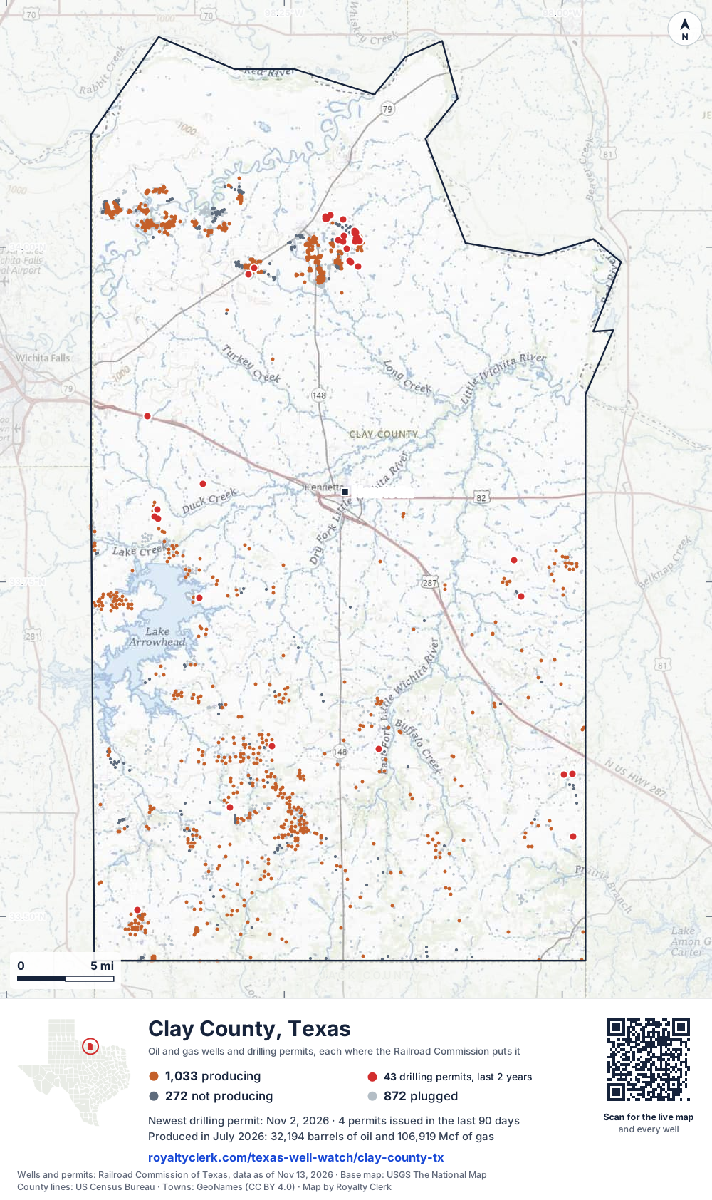
- Drilling locations43Permits issued in the last two years
- Producing wells1,036On a lease reporting production now
- Not producing274Shut in, inactive or no lease on record
- Plugged867The state's wellbore record says plugged
Sources: Railroad Commission of Texas well layers and permit files, US Census Bureau county outline, town points from GeoNames (CC BY 4.0), base map from USGS The National Map. A dot is a surface location; a horizontal well runs a mile or more from it.
2,177 wells with a location on the state's map and 43 drilling locations permitted in the last 24 months, each where the Railroad Commission puts it.
A permit is not a well.
Wells near each town in Clay County
Wells within 10 miles of each town, on either side of the county line.
Use this map on your site
You may show this map on any site, unchanged. Keep the credit line and its link to Royalty Clerk under the map. The picture updates by itself as the state records new wells and permits.
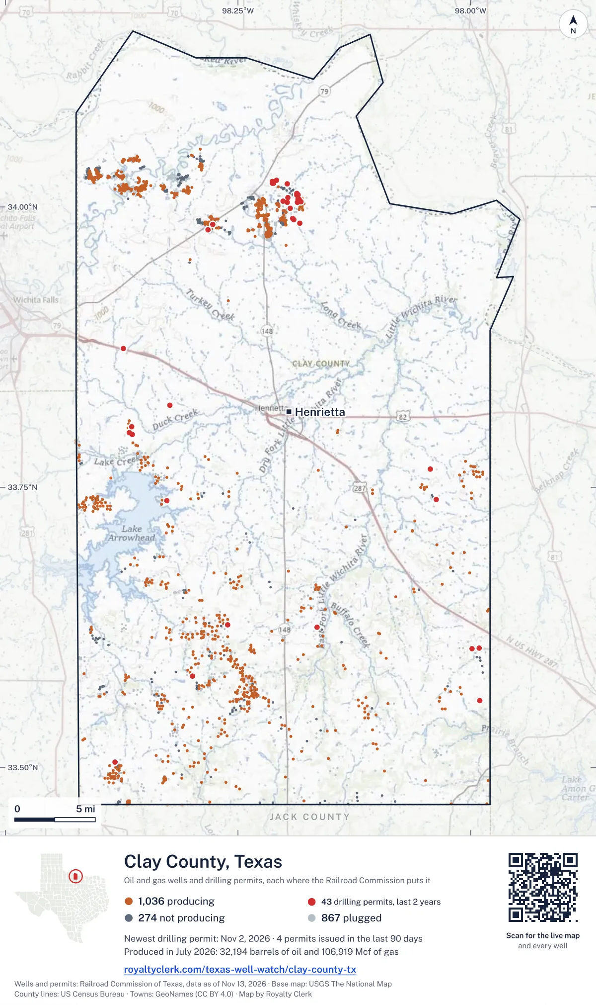
<a href="https://royaltyclerk.com/texas-well-watch/clay-county-tx"><img src="https://royaltyclerk.com/maps/county-wells/clay-county-tx.svg" alt="Map of Clay County, Texas, with 2,177 oil and gas wells and 43 recent drilling locations as dots." width="1000" height="1684" loading="lazy" style="max-width:100%;height:auto;border:0"></a>
<p style="margin:4px 0 0;font-size:14px">Map: <a href="https://royaltyclerk.com/texas-well-watch/clay-county-tx">Clay County, Texas oil and gas wells</a> by Royalty Clerk, from Railroad Commission of Texas records</p>
The last twelve months
Month by month in Clay County
| Month | Permits | Completions | First production |
|---|---|---|---|
| Nov 2026 | 1 | 0 | 0 |
| Oct 2026 | 2 | 0 | 0 |
| Sep 2026 | 1 | 0 | 0 |
| Aug 2026 | 1 | 1 | 0 |
| Jun 2026 | 1 | 2 | 1 |
| May 2026 | 2 | 2 | 0 |
| Apr 2026 | 5 | 0 | 1 |
| Mar 2026 | 1 | 1 | 0 |
| Feb 2026 | 1 | 1 | 1 |
| Jan 2026 | 0 | 1 | 0 |
| Dec 2025 | 4 | 0 | 0 |
Counted from November 17, 2025 to November 2, 2026, so the first and last months are partial. Source: Railroad Commission of Texas data sets.
Free, no sign-in
The newest drilling permits in Clay County
| Issued | Lease and well | Operator | Drilling began | Depth, ft | API number | Coordinates | Permit |
|---|---|---|---|---|---|---|---|
| 2026-11-02 | KEETON 35new drill · verticalMuirfield Exploration, Ltd.API 42-077-35430 · permit 091984934.00405, -98.186272,000 ft | Muirfield Exploration, Ltd. | |||||
| 2026-10-28 | SCALING 1new drill · verticalB.o.l.d. Oil and Gas, LLCAPI 42-077-35429 · permit 091976533.58176, -98.298696,500 ft | B.o.l.d. Oil and Gas, LLC | |||||
| 2026-10-28 | HALSELL, FURD -A- 33re-entry · verticalBridwell Oil Co.API 42-077-80847 · permit 091973533.73813, -98.326624,875 ft | Bridwell Oil Co. | |||||
| 2026-09-14 | JOHNNY RINGGOLD 1new drill · verticalExtech Operating, LLCAPI 42-077-35428 · permit 091853233.76636, -98.042966,500 ft | Extech Operating, LLC | |||||
| 2026-08-05 | BELLEVUE UNIT 304new drill · verticalQuail Ridge Operating LLCAPI 42-077-35426 · permit 091755733.60637, -97.990866,100 ft | Quail Ridge Operating LLC | |||||
| 2026-06-02 | SB1-MP 199.571 1new drill · verticalEnterprise Products OperatingllcAPI 42-077-35425 · permit 091565433.87374, -98.37343400 ft | Enterprise Products Operatingllc | |||||
| 2026-05-22 | ORTON B UNIT 2Hrecompletion · horizontalQuail Ridge Operating LLCAPI 42-077-35351 · permit 091523133.60637, -97.990676,600 ft | Quail Ridge Operating LLC | |||||
| 2026-05-15 | HENDERSON 1recompletion · verticalDRY Creek Operating, LLCAPI 42-077-35339 · permit 091558833.50494, -98.382445,660 ft | DRY Creek Operating, LLC | |||||
| 2026-04-24 | KARMICHAEL 1new drill · verticalMuirfield Exploration, Ltd.API 42-077-35424 · permit 091510833.99895, -98.19414drilling began 2026-05-05 · 2,000 ft | Muirfield Exploration, Ltd. | |||||
| 2026-04-23 | ROSS 3new drill · verticalFelty Drilling Co. IncAPI 42-077-35423 · permit 091497233.79720, -98.36389drilling began 2026-07-20 · 5,800 ft | Felty Drilling Co. Inc | |||||
| 2026-04-21 | FULLER 1recompletion · verticalTrio Consulting & Management,llcAPI 42-077-35003 · permit 091492333.62520, -98.16520drilling began 2022-03-31 · 6,430 ft | Trio Consulting & Management,llc | |||||
| 2026-04-17 | KEETON 38new drill · verticalMuirfield Exploration, Ltd.API 42-077-35422 · permit 091488734.00671, -98.18551drilling began 2026-04-28 · 2,000 ft | Muirfield Exploration, Ltd. | |||||
| 2026-04-07 | ORTON B UNIT 3Hnew drill · horizontalQuail Ridge Operating LLCAPI 42-077-35421 · permit 091439933.60637, -97.99073drilling began 2026-08-14 · 6,600 ft | Quail Ridge Operating LLC | |||||
| 2026-03-26 | KEETON 37new drill · verticalMuirfield Exploration, Ltd.API 42-077-35420 · permit 091437234.00596, -98.18432drilling began 2026-04-10 · 2,000 ft | Muirfield Exploration, Ltd. | |||||
| 2026-02-10 | KEETON 36new drill · verticalMuirfield Exploration, Ltd.API 42-077-35419 · permit 091335234.00479, -98.18215drilling began 2026-02-13 · 2,000 ft | Muirfield Exploration, Ltd. | |||||
| 2025-12-18 | ROWDY 15new drill · verticalMuirfield Exploration, Ltd.API 42-077-35418 · permit 091222634.02395, -98.208401,000 ft | Muirfield Exploration, Ltd. | |||||
| 2025-12-18 | ROWDY 12new drill · verticalMuirfield Exploration, Ltd.API 42-077-35417 · permit 091221734.02261, -98.21278drilling began 2026-02-05 · 1,000 ft | Muirfield Exploration, Ltd. | |||||
| 2025-12-12 | ROWDY 11new drill · verticalMuirfield Exploration, Ltd.API 42-077-35416 · permit 091213234.02096, -98.21178drilling began 2026-01-21 · 1,000 ft | Muirfield Exploration, Ltd. | |||||
| 2025-12-12 | ROWDY 10new drill · verticalMuirfield Exploration, Ltd.API 42-077-35415 · permit 091213134.02096, -98.21277drilling began 2026-01-19 · 1,000 ft | Muirfield Exploration, Ltd. | |||||
| 2025-11-14 | CATHODIC PROTECTION 31new drill · verticalAtmos Pipeline - TexasAPI 42-077-35414 · permit 091139633.82300, -98.32311550 ft | Atmos Pipeline - Texas | |||||
| 2025-10-24 | STINE -A- 3Drecompletion · verticalYet Profits, LLCAPI 42-077-80217 · permit 091122533.97965, -98.282232,000 ft | Yet Profits, LLC | |||||
| 2025-10-22 | WRIGHT UNIT 1new drill · verticalQuail Ridge Operating LLCAPI 42-077-35413 · permit 091120133.60588, -97.998266,500 ft | Quail Ridge Operating LLC | |||||
| 2025-09-19 | NONAME 1new drill · verticalMuirfield Exploration, Ltd.API 42-077-35412 · permit 091055333.98547, -98.18337drilling began 2025-09-29 · 2,000 ft | Muirfield Exploration, Ltd. | |||||
| 2025-09-17 | TREASURE 1new drill · verticalMuirfield Exploration, Ltd.API 42-077-35411 · permit 0910497drilling began 2025-09-23 · 2,000 ft | Muirfield Exploration, Ltd. | |||||
| 2025-08-05 | KLEMENT 3new drill · verticalMuirfield Exploration, Ltd.API 42-077-35410 · permit 090968834.01130, -98.185612,000 ft | Muirfield Exploration, Ltd. | |||||
| 2025-07-15 | KEETON 34new drill · verticalMuirfield Exploration, Ltd.API 42-077-35409 · permit 090922434.00676, -98.18453drilling began 2025-07-22 · 2,000 ft | Muirfield Exploration, Ltd. | |||||
| 2025-07-15 | EXTECH MEYERS 2new drill · verticalExtech Operating, LLCAPI 42-077-35408 · permit 090922333.62742, -98.26117drilling began 2025-07-23 · 6,500 ft | Extech Operating, LLC | |||||
| 2025-07-07 | KEETON 33new drill · verticalMuirfield Exploration, Ltd.API 42-077-35407 · permit 090904834.01074, -98.18562drilling began 2025-07-14 · 2,000 ft | Muirfield Exploration, Ltd. | |||||
| 2025-06-30 | KLEMENT 2new drill · verticalMuirfield Exploration, Ltd.API 42-077-35406 · permit 090895034.01212, -98.18661drilling began 2025-07-08 · 2,000 ft | Muirfield Exploration, Ltd. | |||||
| 2025-06-13 | BENNETT 2new drill · verticalMuirfield Exploration, Ltd.API 42-077-35405 · permit 090860133.98852, -98.18980drilling began 2025-06-23 · 2,000 ft | Muirfield Exploration, Ltd. | |||||
| 2025-06-13 | KLEMENT 1new drill · verticalMuirfield Exploration, Ltd.API 42-077-35404 · permit 090856334.01130, -98.18660drilling began 2025-06-16 · 2,000 ft | Muirfield Exploration, Ltd. | |||||
| 2025-05-23 | EDDIE DUNN 3new drill · verticalMuirfield Exploration, Ltd.API 42-077-35403 · permit 090815334.00521, -98.20124drilling began 2025-06-02 · 2,000 ft | Muirfield Exploration, Ltd. | |||||
| 2025-05-23 | EDDIE DUNN 2new drill · verticalMuirfield Exploration, Ltd.API 42-077-35402 · permit 090813834.00846, -98.19629drilling began 2025-05-25 · 2,000 ft | Muirfield Exploration, Ltd. | |||||
| 2025-04-10 | KEETON 32new drill · verticalMuirfield Exploration, Ltd.API 42-077-35400 · permit 090662934.01064, -98.18660drilling began 2025-05-19 · 2,000 ft | Muirfield Exploration, Ltd. | |||||
| 2025-03-19 | TEXAKOMA COMANCHE 3new drill · verticalGreat American Resources Inc.API 42-077-35401 · permit 090673133.73927, -98.0367610,000 ft | Great American Resources Inc. | |||||
| 2025-03-04 | STINE -A- 100new drill · verticalYet Profits, LLCAPI 42-077-35395 · permit 090512233.98421, -98.277292,000 ft | Yet Profits, LLC | |||||
| 2025-02-27 | ROSS 2new drill · verticalFelty Drilling Co. IncAPI 42-077-35399 · permit 090604333.79894, -98.36677drilling began 2025-03-27 · 5,800 ft | Felty Drilling Co. Inc | |||||
| 2025-02-19 | ROSS 1new drill · verticalFelty Drilling Co. IncAPI 42-077-35398 · permit 090601133.80397, -98.36415drilling began 2025-03-05 · 5,800 ft | Felty Drilling Co. Inc | |||||
| 2025-02-14 | EDDIE DUNN 1new drill · verticalMuirfield Exploration, Ltd.API 42-077-35397 · permit 090594234.00430, -98.19682drilling began 2025-03-18 · 2,000 ft | Muirfield Exploration, Ltd. | |||||
| 2025-01-24 | BENNETT 1new drill · verticalMuirfield Exploration, Ltd.API 42-077-35396 · permit 090540733.98970, -98.19152drilling began 2025-03-25 · 2,000 ft | Muirfield Exploration, Ltd. | |||||
| 2024-12-10 | EAGLE UNIT 3Hnew drill · horizontalQuail Ridge Operating LLCAPI 42-077-35394 · permit 090452633.55975, -97.99034drilling began 2024-12-16 · 6,600 ft | Quail Ridge Operating LLC | |||||
| 2024-12-10 | EAGLE UNIT 2Hnew drill · horizontalQuail Ridge Operating LLCAPI 42-077-35393 · permit 090452533.55980, -97.99034drilling began 2024-12-15 · 6,600 ft | Quail Ridge Operating LLC | |||||
| 2024-12-10 | EAGLE UNIT 1Hnew drill · horizontalQuail Ridge Operating LLCAPI 42-077-35392 · permit 090452433.55986, -97.99034drilling began 2024-12-14 · 6,600 ft | Quail Ridge Operating LLC | |||||
| 2024-12-10 | NOLAN 2new drill · verticalMuirfield Exploration, Ltd.API 42-077-35391 · permit 090443634.02086, -98.19693drilling began 2024-12-17 · 2,000 ft | Muirfield Exploration, Ltd. | |||||
| 2024-10-17 | NOLAN 1new drill · verticalMuirfield Exploration, Ltd.API 42-077-35390 · permit 090318734.01993, -98.19644drilling began 2024-11-19 · 2,000 ft | Muirfield Exploration, Ltd. | |||||
| 2024-10-04 | HARDING 1new drill · verticalMuirfield Exploration, Ltd.API 42-077-35389 · permit 090308834.00261, -98.34978drilling began 2024-11-14 · 2,000 ft | Muirfield Exploration, Ltd. | |||||
| 2024-09-04 | HOLT 'D' 1new drill · verticalExtech Operating, LLCAPI 42-077-35388 · permit 090238833.62834, -98.26527drilling began 2024-12-30 · 6,000 ft | Extech Operating, LLC | |||||
| 2024-06-20 | CPU 105 1new drill · verticalEnterprise Products Texas Op LLCAPI 42-077-35387 · permit 090046433.82424, -98.35078400 ft | Enterprise Products Texas Op LLC | |||||
| 2024-06-18 | SWANDA NW 2new drill · verticalMuirfield Exploration, Ltd.API 42-077-35386 · permit 090043533.98680, -98.36850drilling began 2024-06-19 · 2,000 ft | Muirfield Exploration, Ltd. | |||||
| 2024-05-10 | ROWDY 9new drill · verticalMuirfield Exploration, Ltd.API 42-077-35385 · permit 089959934.01025, -98.20677drilling began 2024-05-10 · 2,000 ft | Muirfield Exploration, Ltd. |
These are the newest 50 of 68 permits on file for Clay County. The rest follow, 50 to a page.
A permit is permission to drill, not a well. Source: Railroad Commission of Texas drilling permit files.
Year by year
Drilling permits issued in Clay County, by year
| Year | Permits issued |
|---|---|
| 2026 so far | 15 |
| 2025 | 25 |
| 2024 | 19 |
| 2023 | 9 |
Counted from the permit files we hold, which start in 2023; that first year may be partial. Source: Railroad Commission of Texas drilling permit files.
The latest
The most recent records
| Date | What, who and where |
|---|---|
| 2026-11-02 | Permit issued: Muirfield Exploration, Ltd.KEETON · A-712 · permit 0919849 |
| 2026-10-28 | Permit issued: B.o.l.d. Oil and Gas, LLCSCALING · A-209 · permit 0919765 |
| 2026-10-28 | Permit issued: Bridwell Oil Co.HALSELL, FURD -A- · A-842 · permit 0919735 |
| 2026-09-14 | Permit issued: Extech Operating, LLCJOHNNY RINGGOLD · A-308 · permit 0918532 |
| 2026-08-31 | Completed: Felty Drilling Co. IncROSS · A-703 · permit 0914972 |
| 2026-08-05 | Permit issued: Quail Ridge Operating LLCBELLEVUE UNIT · A-535 · permit 0917557 |
| 2026-06-11 | Completed: Muirfield Exploration, Ltd.KARMICHAEL · A-374 · permit 0915108 |
| 2026-06-02 | Permit issued: Enterprise Products OperatingllcSB1-MP 199.571 · A-959 · permit 0915654 |
| 2026-06-02 | Completed: Bridwell Oil Co.BRIDWELL RIVER RANCH |
| 2026-06-01 | First production: Great American Resources Inc.Texakoma Comanche · A-308 · permit 0906731 |
| 2026-05-28 | Completed: Muirfield Exploration, Ltd.KEETON · A-712 · permit 0914887 |
| 2026-05-22 | Permit issued: Quail Ridge Operating LLCORTON B UNIT · A-535 · permit 0915231 |
| 2026-05-16 | Completed: Muirfield Exploration, Ltd.KEETON · A-712 · permit 0914372 |
| 2026-05-15 | Permit issued: DRY Creek Operating, LLCHENDERSON · A-464 · permit 0915588 |
| 2026-04-24 | Permit issued: Muirfield Exploration, Ltd.KARMICHAEL · A-374 · permit 0915108 |
Coming up
First checks coming due in Clay County
- ROSS, Felty Drilling Co. Incby December 29, 2026
Follow it
Watch Clay County, or one abstract
What do you want to follow?
Where the land is. Your deed or lease names it.
For example A-1119, or Bush, or T&P 38. Your deed or the tax bill has it.
Other counties
Drilling activity in other counties
Related
Related
- ToolTexas well watchPermit, completion, first production and when the first check is due.
- ToolIs this buyout offer fair?The offer as months of your income, what the acres mean, and the questions to ask.
- ToolIs this lease offer good?Bonus and royalty against the county, and a scan of the lease's clauses.
- Texas dataTexas operator changesWho took over whose leases in the last 24 months.
- ToolLate payment interestDeadlines and the interest a late payment earns.
- Texas dataTexas oil and gas atlas254 counties, every lease, operator and field.
FAQ
Questions people ask
How many wells were permitted in Clay County in the last year?
The Railroad Commission issued 19 drilling permits in Clay County in the twelve months to November 2, 2026, and recorded 8 completions and 3 first-production reports. A permit is permission to drill, not a well.
How do I get an alert when a permit is issued near my land in Clay County?
Choose your abstract on this page, or the whole county, and sign in. You get one email a week, only when something new is recorded after you sign up. The alert says whether an event is on an interest in your Mineral File, on a place you follow, or only nearby.
When is my first royalty check due after a new well?
Natural Resources Code section 91.402(a) says on or before 120 days after the end of the month of first sale of production from the well. The state's first-production month is the closest public marker, so the date on this page is the earliest, not a certainty.
Got a new well on your land?
The first check is due within 120 days after the end of the month of first sale.
Sources
Primary sources, opened on 29 September 2026. Statute text is the current version on statutes.capitol.texas.gov.