
Crockett County, Texas
Crockett County drilling permits: what the state recorded
- 19drilling permits
- 21completions
- 5first-production reports
- in the last twelve months
Wells by coordinates
Oil wells and drilling locations in Crockett County
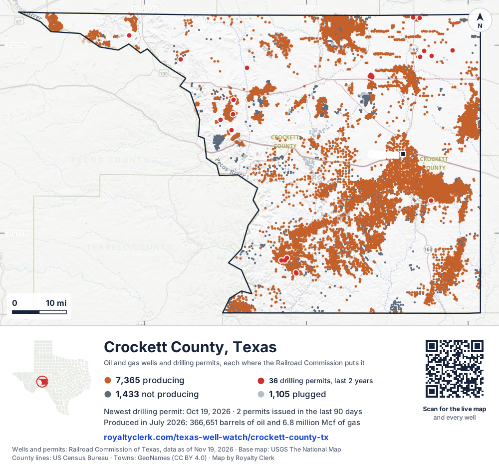
- Drilling locations36Permits issued in the last two years
- Producing wells7,365On a lease reporting production now
- Not producing1,434Shut in, inactive or no lease on record
- Plugged1,104The state's wellbore record says plugged
Sources: Railroad Commission of Texas well layers and permit files, US Census Bureau county outline, town points from GeoNames (CC BY 4.0), base map from USGS The National Map. A dot is a surface location; a horizontal well runs a mile or more from it.
9,903 wells with a location on the state's map and 36 drilling locations permitted in the last 24 months, each where the Railroad Commission puts it.
A permit is not a well.
Crockett County is one of the 61 counties of the Permian Basin
Wells near each town in Crockett County
Wells within 10 miles of each town, on either side of the county line.
Use this map on your site
You may show this map on any site, unchanged. Keep the credit line and its link to Royalty Clerk under the map. The picture updates by itself as the state records new wells and permits.
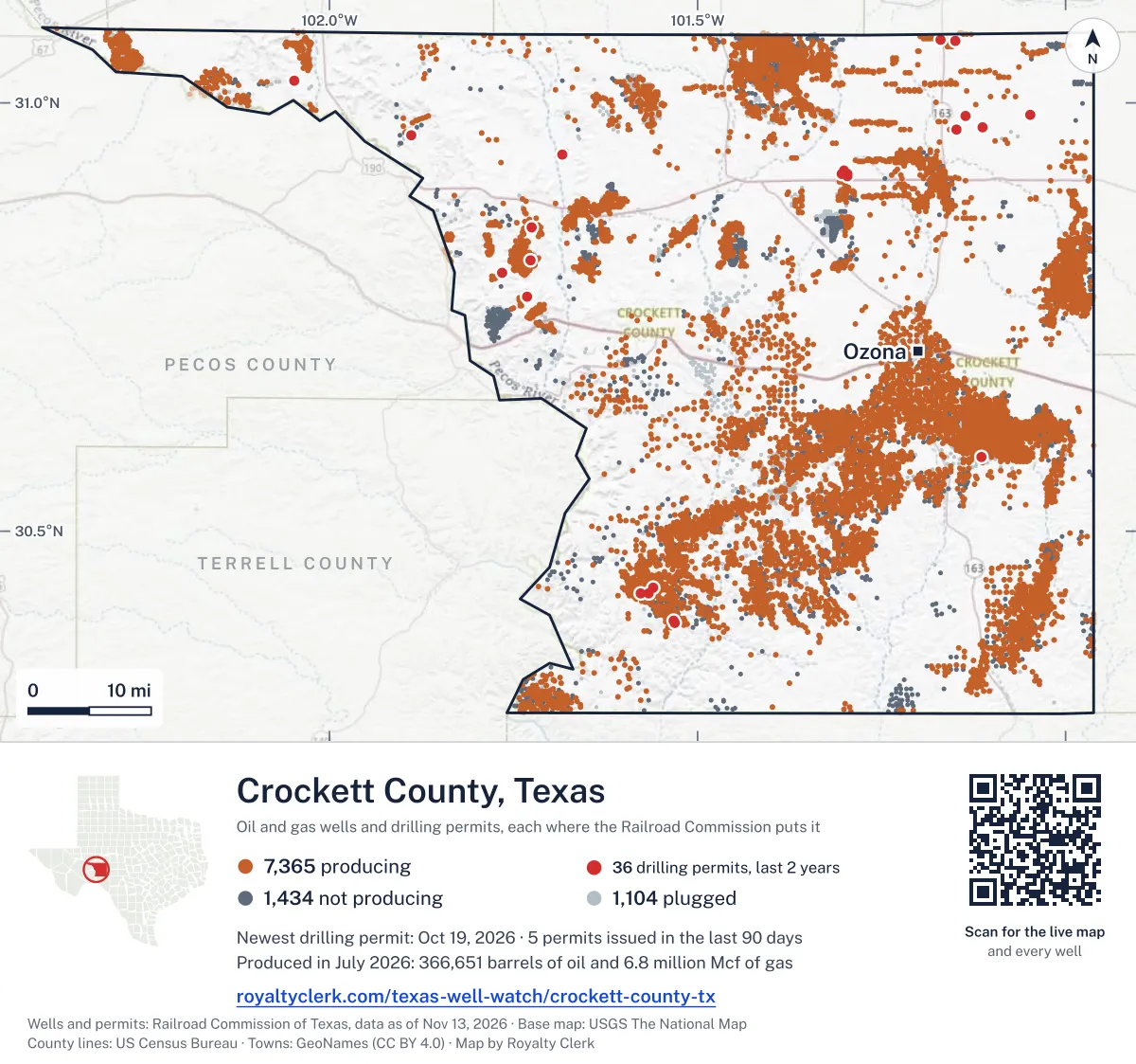
<a href="https://royaltyclerk.com/texas-well-watch/crockett-county-tx"><img src="https://royaltyclerk.com/maps/county-wells/crockett-county-tx.svg" alt="Map of Crockett County, Texas, with 9,903 oil and gas wells and 36 recent drilling locations as dots." width="1000" height="936" loading="lazy" style="max-width:100%;height:auto;border:0"></a>
<p style="margin:4px 0 0;font-size:14px">Map: <a href="https://royaltyclerk.com/texas-well-watch/crockett-county-tx">Crockett County, Texas oil and gas wells</a> by Royalty Clerk, from Railroad Commission of Texas records</p>
The last twelve months
Month by month in Crockett County
| Month | Permits | Completions | First production |
|---|---|---|---|
| Oct 2026 | 2 | 0 | 0 |
| Sep 2026 | 0 | 1 | 0 |
| Aug 2026 | 5 | 0 | 0 |
| Jul 2026 | 4 | 0 | 0 |
| Jun 2026 | 1 | 2 | 0 |
| May 2026 | 0 | 1 | 0 |
| Apr 2026 | 0 | 2 | 1 |
| Mar 2026 | 0 | 8 | 1 |
| Feb 2026 | 4 | 2 | 1 |
| Jan 2026 | 2 | 4 | 1 |
| Dec 2025 | 1 | 0 | 1 |
| Nov 2025 | 0 | 1 | 0 |
Counted from November 15, 2025 to October 19, 2026, so the first and last months are partial. Source: Railroad Commission of Texas data sets.
Free, no sign-in
The newest drilling permits in Crockett County
| Issued | Lease and well | Operator | Drilling began | Depth, ft | API number | Coordinates | Permit |
|---|---|---|---|---|---|---|---|
| 2026-10-19 | UNIVERSITY 40 B 1603WCnew drill · horizontalSem Operating Company LLCAPI 42-105-42579 · permit 091938031.07238, -101.15019drilling began 2026-10-28 · 10,000 ft | Sem Operating Company LLC | |||||
| 2026-10-19 | UNIVERSITY 40 B 1601WCnew drill · horizontalSem Operating Company LLCAPI 42-105-42578 · permit 091937931.07238, -101.15028drilling began 2026-10-27 · 10,000 ft | Sem Operating Company LLC | |||||
| 2026-08-21 | HATTON, E.H. ESTATE '14' 4recompletion · verticalScout Energy Management LLCAPI 42-105-32307 · permit 091798430.42743, -101.577137,450 ft | Scout Energy Management LLC | |||||
| 2026-08-20 | HATTON, E.H. ESTATE '8D' 3recompletion · verticalScout Energy Management LLCAPI 42-105-32135 · permit 091794930.43399, -101.560677,500 ft | Scout Energy Management LLC | |||||
| 2026-08-20 | WARREN, W. K. FOUNDATION '24' 12recompletion · verticalScout Energy Management LLCAPI 42-105-38645 · permit 091792430.39246, -101.531557,235 ft | Scout Energy Management LLC | |||||
| 2026-08-07 | WARREN,W. K. FOUNDATION '24' 1recompletion · verticalScout Energy Management LLCAPI 42-105-31990 · permit 091767130.39528, -101.531797,400 ft | Scout Energy Management LLC | |||||
| 2026-08-07 | HATTON, E.H. ESTATE '14B' 3recompletion · verticalScout Energy Management LLCAPI 42-105-32182 · permit 091761330.42737, -101.566507,500 ft | Scout Energy Management LLC | |||||
| 2026-07-13 | UNIVERSITY 40 1511WCnew drill · horizontalSem Operating Company LLCAPI 42-105-42577 · permit 091703331.07354, -101.16974drilling began 2026-07-18 · 10,000 ft | Sem Operating Company LLC | |||||
| 2026-07-13 | UNIVERSITY 40 1509WCnew drill · horizontalSem Operating Company LLCAPI 42-105-42576 · permit 091703231.07354, -101.16983drilling began 2026-07-19 · 10,000 ft | Sem Operating Company LLC | |||||
| 2026-07-13 | UNIVERSITY 40 1507WCnew drill · horizontalSem Operating Company LLCAPI 42-105-42575 · permit 091703131.07354, -101.16993drilling began 2026-07-19 · 10,000 ft | Sem Operating Company LLC | |||||
| 2026-07-13 | UNIVERSITY 40 1503WCnew drill · horizontalSem Operating Company LLCAPI 42-105-42574 · permit 091702831.07354, -101.17002drilling began 2026-07-20 · 10,000 ft | Sem Operating Company LLC | |||||
| 2026-06-02 | EAGLE DRAW '11' 1recompletion · horizontalWalsh & Watts, Inc.API 42-105-38575 · permit 091541130.81639, -101.726505,904 ft | Walsh & Watts, Inc. | |||||
| 2026-02-23 | UNIVERSITY 66 67 68 350new drill · verticalPetx Operating LLCAPI 42-105-42573 · permit 091361430.91398, -101.29668drilling began 2026-03-31 · 2,000 ft | Petx Operating LLC | |||||
| 2026-02-23 | UNIVERSITY 66 67 68 325new drill · verticalPetx Operating LLCAPI 42-105-42572 · permit 091361330.91736, -101.29692drilling began 2026-03-24 · 2,000 ft | Petx Operating LLC | |||||
| 2026-02-23 | UNIVERSITY 66 67 68 225new drill · verticalPetx Operating LLCAPI 42-105-42571 · permit 091361230.91751, -101.30411drilling began 2026-03-16 · 2,000 ft | Petx Operating LLC | |||||
| 2026-02-19 | UNIVERSITY 66 67 68 125new drill · verticalPetx Operating LLCAPI 42-105-42570 · permit 091339830.92053, -101.30160drilling began 2026-03-06 · 2,000 ft | Petx Operating LLC | |||||
| 2026-01-09 | SHANNON ESTATE 'A' 3301recompletion · verticalScout Energy Management LLCAPI 42-105-34795 · permit 091254830.93964, -101.684187,200 ft | Scout Energy Management LLC | |||||
| 2026-01-08 | OWENS 19 1field transfer · verticalBeach Exploration, Inc.API 42-105-35728 · permit 091248730.80099, -101.76620drilling began 1990-03-10 · 6,100 ft | Beach Exploration, Inc. | |||||
| 2025-12-30 | OWENS 1new drill · verticalKaler Energy Corp.API 42-105-42569 · permit 091248630.77438, -101.73156drilling began 2026-03-14 · 2,200 ft | Kaler Energy Corp. | |||||
| 2025-11-07 | SIMPSON CANYON 1045 1re-entry · verticalSurge Solutions, Inc.API 42-105-39253 · permit 091147830.96156, -101.889505,900 ft | Surge Solutions, Inc. | |||||
| 2025-11-04 | SHANNON ESTATE 44re-entry · verticalAspen Operating Company, L.L.C.API 42-105-40097 · permit 091153030.85510, -101.72509drilling began 2026-03-26 · 3,170 ft | Aspen Operating Company, L.L.C. | |||||
| 2025-10-28 | MICHELOB 110recompletion · verticalOgris Operating, LLCAPI 42-105-42547 · permit 091139431.02576, -102.047298,200 ft | Ogris Operating, LLC | |||||
| 2025-06-25 | UNIVERSITY LANDS 214 N043Hnew drill · horizontalTriple Crown Resources, LLCAPI 42-105-42566 · permit 090881230.98621, -101.04843drilling began 2025-07-16 · 9,000 ft | Triple Crown Resources, LLC | |||||
| 2025-06-25 | UNIVERSITY LANDS 214 N042Hnew drill · horizontalTriple Crown Resources, LLCAPI 42-105-42565 · permit 090881130.98621, -101.04849drilling began 2025-07-13 · 9,000 ft | Triple Crown Resources, LLC | |||||
| 2025-06-25 | UNIVERSITY LANDS 214 N041Hnew drill · horizontalTriple Crown Resources, LLCAPI 42-105-42564 · permit 090881030.98621, -101.04856drilling began 2025-07-12 · 9,000 ft | Triple Crown Resources, LLC | |||||
| 2025-06-04 | UNIVERSITY LANDS 225 SOUTH S063Hnew drill · horizontalTriple Crown Resources, LLCAPI 42-105-42563 · permit 090838230.97198, -101.11269drilling began 2025-06-17 · 9,000 ft | Triple Crown Resources, LLC | |||||
| 2025-06-04 | UNIVERSITY LANDS 225 SOUTH S062Hnew drill · horizontalTriple Crown Resources, LLCAPI 42-105-42562 · permit 090838130.97198, -101.11275drilling began 2025-06-20 · 9,000 ft | Triple Crown Resources, LLC | |||||
| 2025-06-04 | UNIVERSITY LANDS 225 SOUTH S061Hnew drill · horizontalTriple Crown Resources, LLCAPI 42-105-42561 · permit 090838030.97198, -101.11281drilling began 2025-06-21 · 9,000 ft | Triple Crown Resources, LLC | |||||
| 2025-05-09 | UNIVERSITY LANDS 224 S044Hnew drill · horizontalTriple Crown Resources, LLCAPI 42-105-42536 · permit 090784830.96908, -101.14865drilling began 2025-05-14 · 9,000 ft | Triple Crown Resources, LLC | |||||
| 2025-05-09 | UNIVERSITY LANDS 224 S043Hnew drill · horizontalTriple Crown Resources, LLCAPI 42-105-42535 · permit 090784630.96908, -101.14878drilling began 2025-05-12 · 9,000 ft | Triple Crown Resources, LLC | |||||
| 2025-05-08 | UNIVERSITY LANDS 224 N274Hnew drill · horizontalTriple Crown Resources, LLCAPI 42-105-42560 · permit 090783830.96908, -101.14871drilling began 2025-05-13 · 9,000 ft | Triple Crown Resources, LLC | |||||
| 2025-05-08 | UNIVERSITY LANDS 224 N273Hnew drill · horizontalTriple Crown Resources, LLCAPI 42-105-42559 · permit 090783730.96908, -101.14884drilling began 2025-05-10 · 9,000 ft | Triple Crown Resources, LLC | |||||
| 2025-02-18 | UNIVERSITY LANDS 226 S264Hnew drill · horizontalTriple Crown Resources, LLCAPI 42-105-42558 · permit 090589330.98453, -101.13622drilling began 2025-03-22 · 9,000 ft | Triple Crown Resources, LLC | |||||
| 2025-02-18 | UNIVERSITY LANDS 226 S263Hnew drill · horizontalTriple Crown Resources, LLCAPI 42-105-42557 · permit 090589230.98453, -101.13628drilling began 2025-03-22 · 9,000 ft | Triple Crown Resources, LLC | |||||
| 2025-02-18 | UNIVERSITY LANDS 226 S262Hnew drill · horizontalTriple Crown Resources, LLCAPI 42-105-42556 · permit 090589030.98453, -101.13635drilling began 2025-03-25 · 9,000 ft | Triple Crown Resources, LLC | |||||
| 2025-02-13 | MCMULLAN 'B' 13recompletion · verticalScout Energy Management LLCAPI 42-105-40501 · permit 090587830.58726, -101.11481drilling began 2008-02-07 · 9,242 ft | Scout Energy Management LLC | |||||
| 2024-11-12 | SHANNON ESTATE NOELKE SE S 37new drill · verticalGreen Century Exp & Prod, LLCAPI 42-105-42555 · permit 090385830.82532, -101.77864drilling began 2024-11-14 · 1,900 ft | Green Century Exp & Prod, LLC | |||||
| 2024-09-03 | UNIVERSITY LANDS 213 N282Hnew drill · horizontalTriple Crown Resources, LLCAPI 42-105-42554 · permit 090236831.00742, -101.06782drilling began 2024-09-27 · 9,000 ft | Triple Crown Resources, LLC | |||||
| 2024-09-03 | UNIVERSITY LANDS 213 N281Hnew drill · horizontalTriple Crown Resources, LLCAPI 42-105-42553 · permit 090236731.00742, -101.06789drilling began 2024-09-26 · 9,000 ft | Triple Crown Resources, LLC | |||||
| 2024-08-12 | SHANNON HOSPITAL 1C 9new drill · verticalStone Creek Operating, LLCAPI 42-105-42552 · permit 090186730.84749, -101.72018drilling began 2024-12-10 · 6,300 ft | Stone Creek Operating, LLC | |||||
| 2024-07-18 | SHANNON ESTATE 1re-entry · verticalAspen Operating Company, L.L.C.permit 09009672,089 ft | Aspen Operating Company, L.L.C. | |||||
| 2024-07-18 | SHANNON ESTATE M 35re-entry · verticalAspen Operating Company, L.L.C.API 42-105-02282 · permit 090096430.83812, -101.74683drilling began 2024-08-20 · 2,176 ft | Aspen Operating Company, L.L.C. | |||||
| 2024-05-22 | UNIVERSITY LANDS 213 S283Hnew drill · horizontalTriple Crown Resources, LLCAPI 42-105-42551 · permit 089981931.00743, -101.06758drilling began 2024-06-02 · 9,000 ft | Triple Crown Resources, LLC | |||||
| 2024-05-22 | UNIVERSITY LANDS 213 S282Hnew drill · horizontalTriple Crown Resources, LLCAPI 42-105-42550 · permit 089981831.00743, -101.06764drilling began 2024-06-01 · 9,000 ft | Triple Crown Resources, LLC | |||||
| 2024-05-22 | UNIVERSITY LANDS 213 S281Hnew drill · horizontalTriple Crown Resources, LLCAPI 42-105-42549 · permit 089981731.00743, -101.06771drilling began 2024-06-01 · 9,000 ft | Triple Crown Resources, LLC | |||||
| 2024-05-22 | UNIVERSITY LANDS 213 N283Hnew drill · horizontalTriple Crown Resources, LLCAPI 42-105-42548 · permit 089981631.00743, -101.06777drilling began 2024-05-30 · 9,000 ft | Triple Crown Resources, LLC | |||||
| 2024-04-15 | MICHELOB 110new drill · verticalOgris Operating, LLCAPI 42-105-42547 · permit 089854731.02576, -102.04729drilling began 2024-07-04 · 8,200 ft | Ogris Operating, LLC | |||||
| 2023-12-14 | UNIVERSITY LANDS 217 S294Hnew drill · horizontalTriple Crown Resources, LLCAPI 42-105-42546 · permit 089560831.00734, -101.08335drilling began 2024-01-19 · 9,000 ft | Triple Crown Resources, LLC | |||||
| 2023-12-14 | UNIVERSITY LANDS 217 S293Hnew drill · horizontalTriple Crown Resources, LLCAPI 42-105-42545 · permit 089560731.00734, -101.08341drilling began 2024-01-17 · 9,000 ft | Triple Crown Resources, LLC | |||||
| 2023-12-14 | UNIVERSITY LANDS 217 B S292Hnew drill · horizontalTriple Crown Resources, LLCAPI 42-105-42544 · permit 089560631.00734, -101.08348drilling began 2024-01-12 · 9,000 ft | Triple Crown Resources, LLC |
These are the newest 50 of 63 permits on file for Crockett County. The rest follow, 50 to a page.
A permit is permission to drill, not a well. Source: Railroad Commission of Texas drilling permit files.
Year by year
Drilling permits issued in Crockett County, by year
| Year | Permits issued |
|---|---|
| 2026 so far | 18 |
| 2025 | 18 |
| 2024 | 11 |
| 2023 | 12 |
| 2017 | 4 |
Counted from the permit files we hold, which start in 2017; that first year may be partial. Source: Railroad Commission of Texas drilling permit files.
The latest
The most recent records
| Date | What, who and where |
|---|---|
| 2026-10-19 | Permit issued: Sem Operating Company LLCUNIVERSITY 40 B · A-U311 · permit 0919380 |
| 2026-10-19 | Permit issued: Sem Operating Company LLCUNIVERSITY 40 B · A-U311 · permit 0919379 |
| 2026-09-17 | Completed: Aspen Operating Company, L.L.C.SHANNON ESTATE · A-1872 |
| 2026-08-21 | Permit issued: Scout Energy Management LLCHATTON, E.H. ESTATE '14' · A-4856 · permit 0917984 |
| 2026-08-20 | Permit issued: Scout Energy Management LLCWARREN, W. K. FOUNDATION '24' · A-5418 · permit 0917924 |
| 2026-08-20 | Permit issued: Scout Energy Management LLCHATTON, E.H. ESTATE '8D' · A-5287 · permit 0917949 |
| 2026-08-07 | Permit issued: Scout Energy Management LLCHATTON, E.H. ESTATE '14B' · A-4856 · permit 0917613 |
| 2026-08-07 | Permit issued: Scout Energy Management LLCWARREN,W. K. FOUNDATION '24' · A-5418 · permit 0917671 |
| 2026-07-13 | Permit issued: Sem Operating Company LLCUNIVERSITY 40 · A-U312 · permit 0917033 |
| 2026-07-13 | Permit issued: Sem Operating Company LLCUNIVERSITY 40 · A-U312 · permit 0917032 |
| 2026-07-13 | Permit issued: Sem Operating Company LLCUNIVERSITY 40 · A-U312 · permit 0917031 |
| 2026-07-13 | Permit issued: Sem Operating Company LLCUNIVERSITY 40 · A-U312 · permit 0917028 |
| 2026-06-29 | Completed: Kaler Energy Corp.OWENS · A-2709 · permit 0912486 |
| 2026-06-25 | Completed: Walsh & Watts, Inc.EAGLE DRAW '11' · A-2904 · permit 0915411 |
| 2026-06-02 | Permit issued: Walsh & Watts, Inc.EAGLE DRAW '11' · A-2904 · permit 0915411 |
Coming up
First checks coming due in Crockett County
- SHANNON ESTATE, Aspen Operating Company, L.L.C.by January 28, 2027
Follow it
Watch Crockett County, or one abstract
What do you want to follow?
Where the land is. Your deed or lease names it.
For example A-1119, or Bush, or T&P 38. Your deed or the tax bill has it.
Other counties
Drilling activity in other counties
Related
Related
- ToolTexas well watchPermit, completion, first production and when the first check is due.
- ToolIs this buyout offer fair?The offer as months of your income, what the acres mean, and the questions to ask.
- ToolIs this lease offer good?Bonus and royalty against the county, and a scan of the lease's clauses.
- Texas dataTexas operator changesWho took over whose leases in the last 24 months.
- ToolLate payment interestDeadlines and the interest a late payment earns.
- Texas dataTexas oil and gas atlas254 counties, every lease, operator and field.
FAQ
Questions people ask
How many wells were permitted in Crockett County in the last year?
The Railroad Commission issued 19 drilling permits in Crockett County in the twelve months to October 19, 2026, and recorded 21 completions and 5 first-production reports. A permit is permission to drill, not a well.
How do I get an alert when a permit is issued near my land in Crockett County?
Choose your abstract on this page, or the whole county, and sign in. You get one email a week, only when something new is recorded after you sign up. The alert says whether an event is on an interest in your Mineral File, on a place you follow, or only nearby.
When is my first royalty check due after a new well?
Natural Resources Code section 91.402(a) says on or before 120 days after the end of the month of first sale of production from the well. The state's first-production month is the closest public marker, so the date on this page is the earliest, not a certainty.
Got a new well on your land?
The first check is due within 120 days after the end of the month of first sale.
Sources
Primary sources, opened on 29 September 2026. Statute text is the current version on statutes.capitol.texas.gov.