
Railroad Commission of Texas · Districts 7C, 08 and 8A · 61 counties
Permian Basin
- 5,205drilling permits in 12 months
- 64%of the state's permits
- 245,967wells on the map
- 243operators filing
Where it is drilled
The Permian Basin's wells and new permits
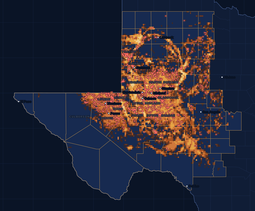
An oil and gas region of West Texas and southeastern New Mexico, about 250 miles wide and 300 miles long, with more than 7,000 fields. The Spraberry, Wolfcamp, Bone Spring, San Andres and Clear Fork are among the formations that produce there; the Delaware and Midland basins are parts of it.
Counties
The 61 counties, by permits
Drilling permits of the last 12 months in each county, and the wells on the state's map there. Each county's live map shows every well and permit where the state puts it.
- 1Midland County67215,018 wells on the mapLive map
- 2Martin County55112,647 wells on the mapLive map
- 3Upton County48012,439 wells on the mapLive map
- 4Reeves County4717,884 wells on the mapLive map
- 5Loving County4155,496 wells on the mapLive map
- 6Reagan County3149,986 wells on the mapLive map
- 7Glasscock County2786,936 wells on the mapLive map
- 8Andrews County21719,604 wells on the mapLive map
- 9Gaines County1828,589 wells on the mapLive map
- 10Howard County16311,199 wells on the mapLive map
- 11Crane County16310,511 wells on the mapLive map
- 12Ector County15517,600 wells on the mapLive map
- 13Yoakum County1548,388 wells on the mapLive map
- 14Winkler County1405,832 wells on the mapLive map
- 15Ward County1238,607 wells on the mapLive map
- 16Culberson County1161,797 wells on the mapLive map
The other 45 counties, A to Z
- Bailey County0 permits · 0 wells
- Borden County82 permits · 1,727 wells
- Brewster County0 permits · 0 wells
- Cochran County1 permits · 4,499 wells
- Coke County9 permits · 863 wells
- Concho County3 permits · 472 wells
- Cottle County0 permits · 175 wells
- Crockett County19 permits · 9,903 wells
- Crosby County1 permits · 1,351 wells
- Dawson County63 permits · 2,936 wells
- Dickens County5 permits · 308 wells
- Edwards County0 permits · 801 wells
- El Paso County0 permits · 0 wells
- Fisher County15 permits · 1,233 wells
- Floyd County0 permits · 2 wells
- Garza County9 permits · 3,544 wells
- Hale County13 permits · 436 wells
- Hockley County34 permits · 8,599 wells
- Hudspeth County0 permits · 9 wells
- Irion County73 permits · 3,998 wells
- Jeff Davis County0 permits · 0 wells
- Kent County10 permits · 1,084 wells
- Kimble County0 permits · 16 wells
- King County13 permits · 898 wells
- Lamb County0 permits · 208 wells
- Lubbock County7 permits · 866 wells
- Lynn County0 permits · 169 wells
- McCulloch County1 permits · 107 wells
- Menard County1 permits · 210 wells
- Mitchell County23 permits · 5,145 wells
- Motley County2 permits · 44 wells
- Nolan County18 permits · 1,482 wells
- Pecos County108 permits · 8,043 wells
- Presidio County0 permits · 3 wells
- Real County0 permits · 8 wells
- Runnels County5 permits · 742 wells
- Schleicher County4 permits · 1,485 wells
- Scurry County46 permits · 7,366 wells
- Sterling County3 permits · 2,481 wells
- Stonewall County7 permits · 1,809 wells
- Sutton County4 permits · 6,443 wells
- Terrell County1 permits · 707 wells
- Terry County21 permits · 1,912 wells
- Tom Green County10 permits · 1,063 wells
- Val Verde County0 permits · 287 wells
Operators
Who files the permits
The companies with the most drilling permits in the play's counties in the last 12 months, as the state names them.
- 1Pioneer Natural Res. USA, Inc.667
- 2Diamondback E&P LLC552
- 3De Central Operating, LLC194
- 4Ovintiv USA Inc.171
- 5Apache Corporation162
- 6Anadarko E&P Onshore LLC150
- 7OXY USA Inc.141
- 8Blackbeard Operating, LLC122
- 9Continental Resources, Inc.122
- 10Cog Operating LLC120
- 11Oxyrock Operating, LLC114
- 12Occidental Permian Ltd.105
Wells completed each year
Most in 2012: 8,407. 2025: 4,037. 2026 so far, lighter.
Towns with the most permits nearby
Drilling permits of the last 12 months within 10 miles of the town.
FAQ
Questions people ask
Is my land in the Permian Basin?
This page counts every well and permit in the 61 counties the Railroad Commission lists for the Permian Basin. A county on the list does not mean the formation lies under every tract in it, or that a well will be drilled on yours. Your county's live map shows the wells and permits around your land, and the operator's division order says which well pays you.
What does the heat on the map show?
Every well on the state's map, counted in squares about two and a half miles wide: the brighter the square, the more wells in it. It shows where drilling has been, old wells included. The red dots are the drilling permits of the last twelve months that have a location on file: where drilling is going now.
Why are some years so different?
Drilling follows prices and the industry's spending. The bars count wells by the completion date the state has on file; the newest months fill in as operators file their completion reports, so the current year is drawn lighter.
Does a permit mean royalties?
No. A permit is permission to drill, not a well, and many are drilled months later or never. Royalties start after a well is completed, produces and the operator sets up its division order. If you own minerals in one of these counties, the first check is usually due about four months after first sales.
Sources
- Railroad Commission of Texas, Permian Basin (the play and its affected counties)www.rrc.texas.gov/oil-and-gas/major-oil-and-gas-formations/permian-basin/ · read November 14, 2026
- Railroad Commission of Texas, major oil and gas formationswww.rrc.texas.gov/oil-and-gas/major-oil-and-gas-formations/ · read November 14, 2026
- Railroad Commission of Texas, well layers, completion records and drilling permit fileswww.rrc.texas.gov/resource-center/research/data-sets-available-for-download/ · loaded as the state publishes them; figures kept six hours
- US Census Bureau, cartographic boundary files (county lines), through the us-atlas package 3.0.1www.census.gov/geographies/mapping-files/time-series/geo/cartographic-boundary.html · built into the site with its well maps
- GeoNames, towns and their points (CC BY 4.0)www.geonames.org/ · built into the site with its town pages