
Harrison County, Texas
Harrison County drilling permits: what the state recorded
- 95drilling permits
- 122completions
- 54first-production reports
- in the last twelve months
Wells by coordinates
Oil wells and drilling locations in Harrison County
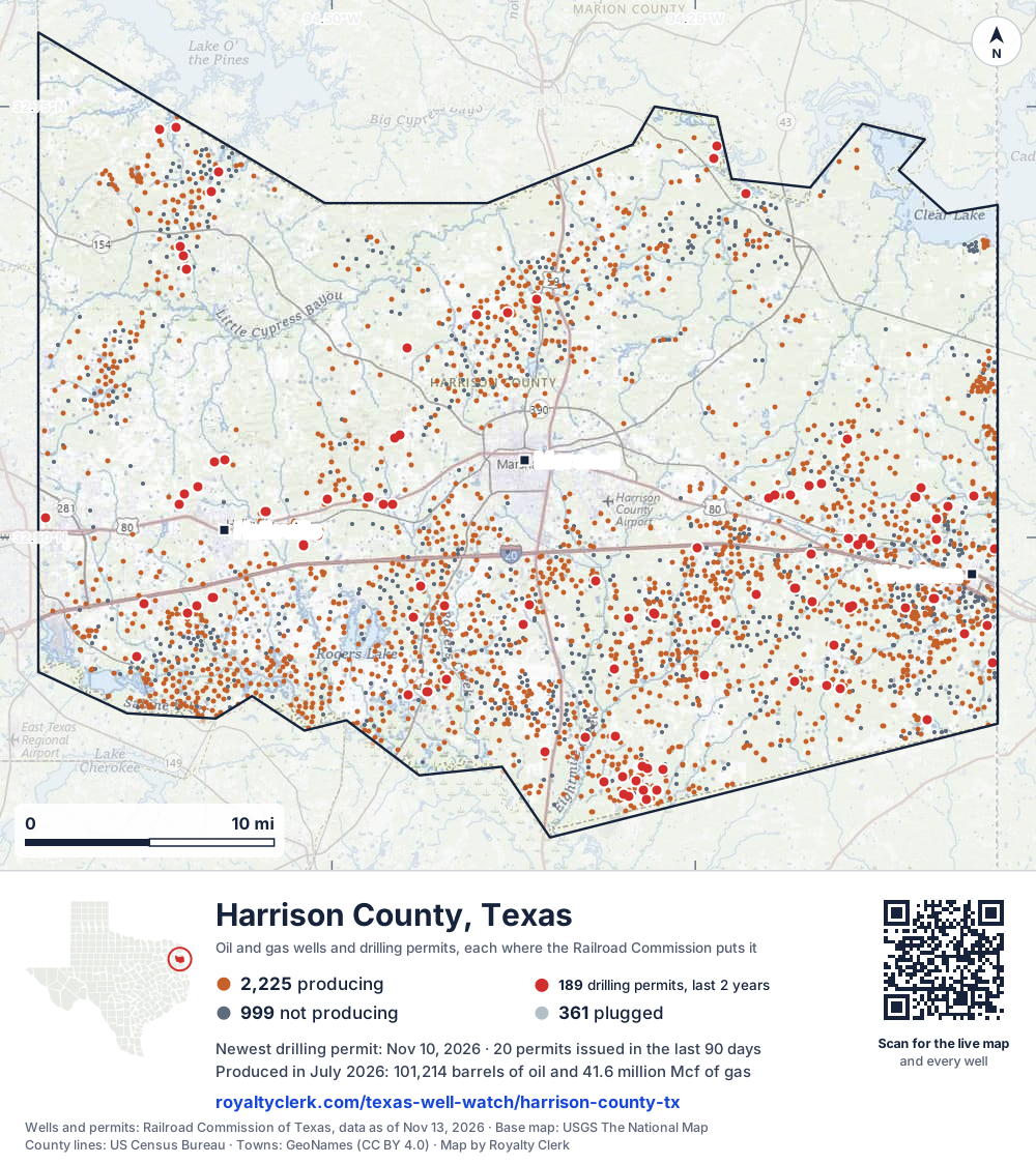
- Drilling locations189Permits issued in the last two years
- Producing wells2,225On a lease reporting production now
- Not producing999Shut in, inactive or no lease on record
- Plugged361The state's wellbore record says plugged
Sources: Railroad Commission of Texas well layers and permit files, US Census Bureau county outline, town points from GeoNames (CC BY 4.0), base map from USGS The National Map. A dot is a surface location; a horizontal well runs a mile or more from it.
3,585 wells with a location on the state's map and 189 drilling locations permitted in the last 24 months, each where the Railroad Commission puts it.
A permit is not a well.
Harrison County is one of the 10 counties of the Haynesville/Bossier Shale
Wells near each town in Harrison County
Wells within 10 miles of each town, on either side of the county line.
Use this map on your site
You may show this map on any site, unchanged. Keep the credit line and its link to Royalty Clerk under the map. The picture updates by itself as the state records new wells and permits.
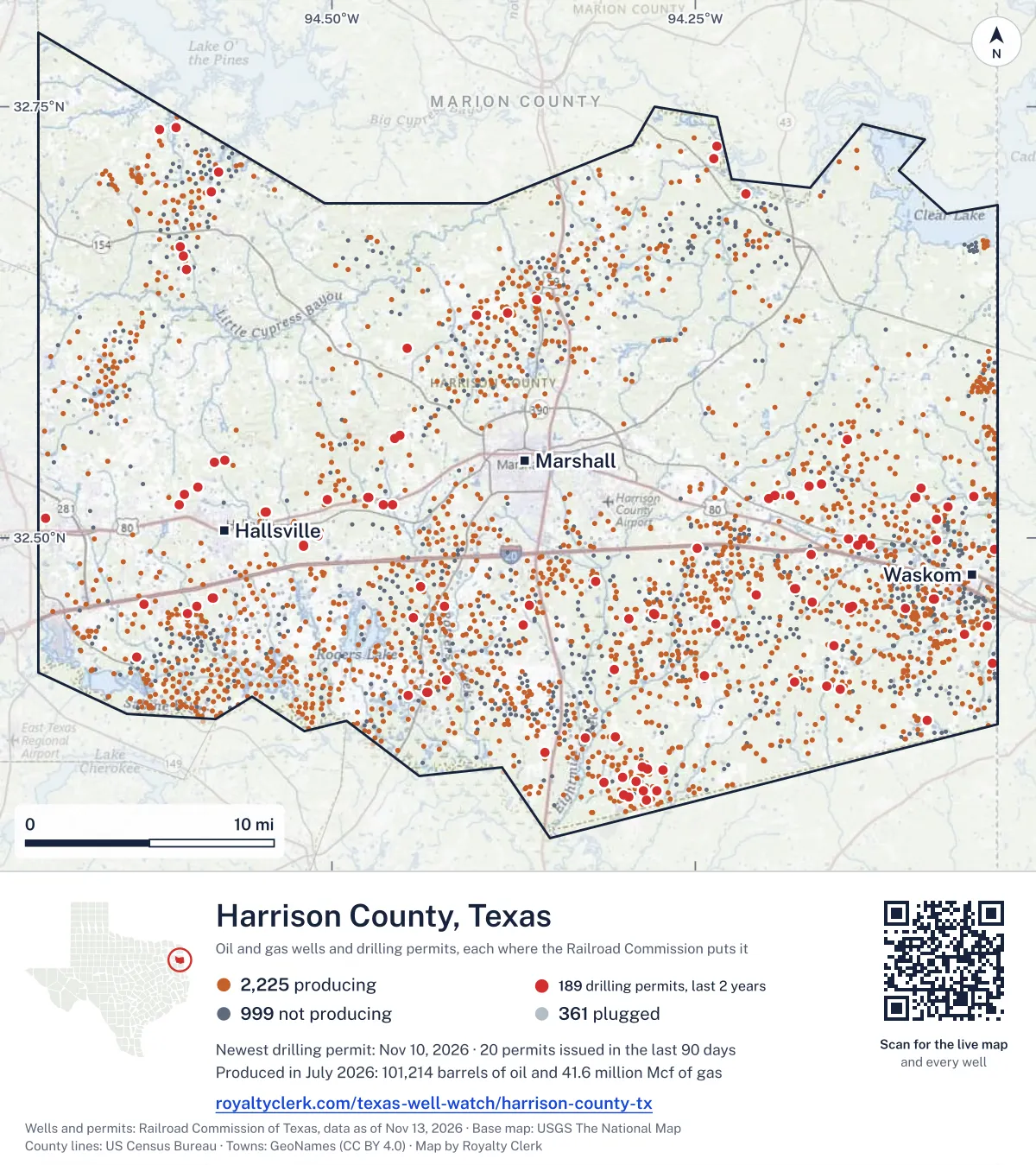
<a href="https://royaltyclerk.com/texas-well-watch/harrison-county-tx"><img src="https://royaltyclerk.com/maps/county-wells/harrison-county-tx.svg" alt="Map of Harrison County, Texas, with 3,585 oil and gas wells and 189 recent drilling locations as dots." width="1000" height="1124" loading="lazy" style="max-width:100%;height:auto;border:0"></a>
<p style="margin:4px 0 0;font-size:14px">Map: <a href="https://royaltyclerk.com/texas-well-watch/harrison-county-tx">Harrison County, Texas oil and gas wells</a> by Royalty Clerk, from Railroad Commission of Texas records</p>
The last twelve months
Month by month in Harrison County
| Month | Permits | Completions | First production |
|---|---|---|---|
| Nov 2026 | 6 | 0 | 0 |
| Oct 2026 | 6 | 0 | 0 |
| Sep 2026 | 5 | 4 | 0 |
| Aug 2026 | 3 | 6 | 7 |
| Jul 2026 | 9 | 11 | 6 |
| Jun 2026 | 4 | 18 | 5 |
| May 2026 | 14 | 9 | 4 |
| Apr 2026 | 13 | 12 | 7 |
| Mar 2026 | 10 | 10 | 1 |
| Feb 2026 | 3 | 21 | 12 |
| Jan 2026 | 6 | 15 | 5 |
| Dec 2025 | 15 | 15 | 7 |
| Nov 2025 | 1 | 1 | 0 |
Counted from November 16, 2025 to November 10, 2026, so the first and last months are partial. Source: Railroad Commission of Texas data sets.
Free, no sign-in
The newest drilling permits in Harrison County
| Issued | Lease and well | Operator | Drilling began | Depth, ft | API number | Coordinates | Permit |
|---|---|---|---|---|---|---|---|
| 2026-11-10 | HAGEN CV 1 (AW) 1Hnew drill · horizontalRfe Operating, LLCAPI 42-203-35837 · permit 091944732.52965, -94.5920112,100 ft | Rfe Operating, LLC | |||||
| 2026-11-09 | HAGEN HVS 3 (AW) 3Hnew drill · horizontalRfe Operating, LLCAPI 42-203-35840 · permit 091945432.52965, -94.5919412,100 ft | Rfe Operating, LLC | |||||
| 2026-11-09 | HAGEN HVS 2 (AW) 2Hnew drill · horizontalRfe Operating, LLCAPI 42-203-35839 · permit 091945032.52965, -94.5920712,100 ft | Rfe Operating, LLC | |||||
| 2026-11-06 | HAGEN HVS 1 (AW) 1Hnew drill · horizontalRfe Operating, LLCAPI 42-203-35838 · permit 091944932.52964, -94.5921412,100 ft | Rfe Operating, LLC | |||||
| 2026-11-03 | GIBSON FURRH 1Hnew drill · horizontalComstock Oil & Gas, LLCAPI 42-203-35844 · permit 091955532.38460, -94.3051130,000 ft | Comstock Oil & Gas, LLC | |||||
| 2026-11-03 | ANDERSON FURRH 1Hnew drill · horizontalComstock Oil & Gas, LLCAPI 42-203-35843 · permit 091955232.38460, -94.3050530,000 ft | Comstock Oil & Gas, LLC | |||||
| 2026-10-27 | G08C MOCHI BN 2UHnew drill · horizontalTgnr East Texas II LLCAPI 42-203-35842 · permit 091954632.43748, -94.1549522,000 ft | Tgnr East Texas II LLC | |||||
| 2026-10-27 | G08C MOCHI AN 1UHnew drill · horizontalTgnr East Texas II LLCAPI 42-203-35841 · permit 091954532.43753, -94.1549422,000 ft | Tgnr East Texas II LLC | |||||
| 2026-10-27 | N. LOUISIANA TIMBERLAND 1recompletion · verticalOil & Gas Production, Inc.API 42-203-34143 · permit 091934832.52910, -94.0946810,400 ft | Oil & Gas Production, Inc. | |||||
| 2026-10-21 | HERRIN HA 1Hnew drill · horizontalComstock Oil & Gas, LLCAPI 42-203-35836 · permit 091878032.46716, -94.2077430,000 ft | Comstock Oil & Gas, LLC | |||||
| 2026-10-21 | HERRIN BRUNE B 2Hnew drill · horizontalComstock Oil & Gas, LLCAPI 42-203-35835 · permit 091877932.46721, -94.2077430,000 ft | Comstock Oil & Gas, LLC | |||||
| 2026-10-20 | HERRIN BRUNE A 1Hnew drill · horizontalComstock Oil & Gas, LLCAPI 42-203-35834 · permit 091877732.46727, -94.2077430,000 ft | Comstock Oil & Gas, LLC | |||||
| 2026-09-30 | PATTON 1Hnew drill · horizontalRose City Resources, LLCAPI 42-203-35832 · permit 091804632.73769, -94.607128,000 ft | Rose City Resources, LLC | |||||
| 2026-09-18 | SUMMERS SPE 1Hnew drill · horizontalPwep Operating, LLCAPI 42-203-35833 · permit 091862432.46135, -94.6292512,000 ft | Pwep Operating, LLC | |||||
| 2026-09-14 | BLOCKER SUS D 4Hnew drill · horizontalComstock Oil & Gas, LLCAPI 42-203-35831 · permit 091787032.45587, -94.2788030,000 ft | Comstock Oil & Gas, LLC | |||||
| 2026-09-14 | BLOCKER SUS C 3Hnew drill · horizontalComstock Oil & Gas, LLCAPI 42-203-35830 · permit 091786732.45587, -94.2787430,000 ft | Comstock Oil & Gas, LLC | |||||
| 2026-09-04 | CRAWFORD OIL UNIT 1 3recompletion · verticalBrookston Energy, Inc.API 42-203-34340 · permit 091821232.35833, -94.3127310,264 ft | Brookston Energy, Inc. | |||||
| 2026-08-31 | BONNER NORTH A HS (AW) 1Hnew drill · horizontalSabine Energy Inc.API 42-203-35829 · permit 091753532.49589, -94.5199012,000 ft | Sabine Energy Inc. | |||||
| 2026-08-28 | BONNER NORTH A CV (AW) 1Hnew drill · horizontalSabine Energy Inc.API 42-203-35828 · permit 091752932.49589, -94.5198312,000 ft | Sabine Energy Inc. | |||||
| 2026-08-24 | JENNIFER STEWART JR 1Hnew drill · horizontalPwep Operating, LLCAPI 42-203-35826 · permit 091695732.45599, -94.5994911,900 ft | Pwep Operating, LLC | |||||
| 2026-07-28 | BONNER NORTH D HS (AW) 4Hnew drill · horizontalSabine Energy Inc.API 42-203-35822 · permit 091669532.49589, -94.5195712,000 ft | Sabine Energy Inc. | |||||
| 2026-07-28 | BONNER NORTH C HS (AW) 3Hnew drill · horizontalSabine Energy Inc.API 42-203-35821 · permit 091669232.49589, -94.5197012,000 ft | Sabine Energy Inc. | |||||
| 2026-07-27 | BONNER NORTH B HS (AW) 2Hnew drill · horizontalSabine Energy Inc.API 42-203-35820 · permit 091668732.49589, -94.5197712,000 ft | Sabine Energy Inc. | |||||
| 2026-07-27 | BONNER NORTH B CV (AW) 2Hnew drill · horizontalSabine Energy Inc.API 42-203-35819 · permit 091668532.49589, -94.5196412,000 ft | Sabine Energy Inc. | |||||
| 2026-07-20 | BRYANT RAINS EB 1Hnew drill · horizontalComstock Oil & Gas, LLCAPI 42-203-35824 · permit 091687132.49421, -94.2484830,000 ft | Comstock Oil & Gas, LLC | |||||
| 2026-07-17 | BRYANT RAINS BMP 1Hnew drill · horizontalComstock Oil & Gas, LLCAPI 42-203-35823 · permit 091686732.49421, -94.2484230,000 ft | Comstock Oil & Gas, LLC | |||||
| 2026-07-16 | HUNT HL A 2Hnew drill · horizontalPwep Operating, LLCAPI 42-203-35827 · permit 091697832.46535, -94.5819711,850 ft | Pwep Operating, LLC | |||||
| 2026-07-16 | CANNON CF 1Hnew drill · horizontalPwep Operating, LLCAPI 42-203-35825 · permit 091695632.46028, -94.5928211,900 ft | Pwep Operating, LLC | |||||
| 2026-07-02 | FLYING LL TRUST 1recompletion · verticalBuffco Production Inc.API 42-203-34617 · permit 091680532.51154, -94.6972512,316 ft | Buffco Production Inc. | |||||
| 2026-06-18 | WOODS 6 (AW) 6Hnew drill · horizontalRfe Operating, LLCAPI 42-203-35817 · permit 091642132.52506, -94.60124drilling began 2026-07-02 · 12,100 ft | Rfe Operating, LLC | |||||
| 2026-06-18 | WOODS 11 (AW) 11Hnew drill · horizontalRfe Operating, LLCAPI 42-203-35818 · permit 091642232.52496, -94.60118drilling began 2026-06-29 · 12,100 ft | Rfe Operating, LLC | |||||
| 2026-06-16 | WOODS 1 (AW) 1Hnew drill · horizontalRfe Operating, LLCAPI 42-203-35816 · permit 091642032.52501, -94.60121drilling began 2026-07-01 · 10,800 ft | Rfe Operating, LLC | |||||
| 2026-06-12 | HUNT HL 1Hnew drill · horizontalPwep Operating, LLCAPI 42-203-35805 · permit 091505232.46535, -94.58189drilling began 2026-08-10 · 11,950 ft | Pwep Operating, LLC | |||||
| 2026-05-28 | H06C HAMILTON DN 4HHnew drill · horizontalTgnr East Texas II LLCAPI 42-203-35814 · permit 091582232.52452, -94.19536drilling began 2026-07-09 · 22,000 ft | Tgnr East Texas II LLC | |||||
| 2026-05-28 | H06C HAMILTON CN 3HHnew drill · horizontalTgnr East Texas II LLCAPI 42-203-35813 · permit 091582132.52447, -94.19539drilling began 2026-07-10 · 22,000 ft | Tgnr East Texas II LLC | |||||
| 2026-05-27 | H06C HAMILTON BN 2HHnew drill · horizontalTgnr East Texas II LLCAPI 42-203-35815 · permit 091582032.52443, -94.19542drilling began 2026-07-11 · 22,000 ft | Tgnr East Texas II LLC | |||||
| 2026-05-27 | H06C HAMILTON AN 1HHnew drill · horizontalTgnr East Texas II LLCAPI 42-203-35812 · permit 091581932.52438, -94.19545drilling began 2026-07-12 · 22,000 ft | Tgnr East Texas II LLC | |||||
| 2026-05-20 | DURKEE GAS UNIT #1 6recompletion · verticalT W Clemons Operating Co., LLCAPI 42-203-32788 · permit 091539932.63027, -94.3794310,025 ft | T W Clemons Operating Co., LLC | |||||
| 2026-05-19 | H06A HOYT BN 2HHnew drill · horizontalTgnr East Texas II LLCAPI 42-203-35810 · permit 091568232.52440, -94.1844322,000 ft | Tgnr East Texas II LLC | |||||
| 2026-05-19 | H06A HOYT AN 1HHnew drill · horizontalTgnr East Texas II LLCAPI 42-203-35811 · permit 091568132.52445, -94.18443drilling began 2026-07-17 · 22,000 ft | Tgnr East Texas II LLC | |||||
| 2026-05-14 | MCCLENDON OIL UNIT 3 3recompletion · verticalBrookston Energy, Inc.API 42-203-33832 · permit 091496632.36621, -94.282708,560 ft | Brookston Energy, Inc. | |||||
| 2026-05-07 | THUNDER VALLEY 2 (AW) 2Hnew drill · horizontalRfe Operating, LLCAPI 42-203-35809 · permit 091516632.51933, -94.4580610,255 ft | Rfe Operating, LLC | |||||
| 2026-05-07 | GEORGE-MATTHEWS A 1Hnew drill · horizontalSponte Operating, Inc.API 42-203-35802 · permit 091510532.41058, -94.43414drilling began 2026-08-06 · 11,500 ft | Sponte Operating, Inc. | |||||
| 2026-05-06 | THUNDER VALLEY 8 (AW) 8Hnew drill · horizontalRfe Operating, LLCAPI 42-203-35808 · permit 091516532.51928, -94.4580611,525 ft | Rfe Operating, LLC | |||||
| 2026-05-06 | THUNDER VALLEY 12 (AW) 12Hnew drill · horizontalRfe Operating, LLCAPI 42-203-35807 · permit 091516432.51922, -94.4580711,525 ft | Rfe Operating, LLC | |||||
| 2026-05-06 | FURRH GAS UNIT NO 3 13recompletion · verticalBrookston Energy, Inc.API 42-203-33941 · permit 091451332.35130, -94.2993210,160 ft | Brookston Energy, Inc. | |||||
| 2026-05-01 | C. B. GEORGE 4recompletion · verticalShelby Operating CompanyAPI 42-203-33663 · permit 091482332.51078, -94.0842211,000 ft | Shelby Operating Company | |||||
| 2026-04-30 | GEORGE-MATTHEWS D 4Hnew drill · horizontalSponte Operating, Inc.API 42-203-35806 · permit 091515732.41057, -94.43439drilling began 2026-08-10 · 11,500 ft | Sponte Operating, Inc. | |||||
| 2026-04-30 | GEORGE-MATTHEWS C 3Hnew drill · horizontalSponte Operating, Inc.API 42-203-35804 · permit 091510932.41057, -94.43431drilling began 2026-08-09 · 11,500 ft | Sponte Operating, Inc. | |||||
| 2026-04-30 | GEORGE-MATTHEWS B 2Hnew drill · horizontalSponte Operating, Inc.API 42-203-35803 · permit 091510732.41058, -94.43423drilling began 2026-08-08 · 11,500 ft | Sponte Operating, Inc. |
These are the newest 50 of 300 permits on file for Harrison County. The rest follow, 50 to a page.
A permit is permission to drill, not a well. Source: Railroad Commission of Texas drilling permit files.
Year by year
Drilling permits issued in Harrison County, by year
| Year | Permits issued |
|---|---|
| 2026 so far | 79 |
| 2025 | 95 |
| 2024 | 77 |
| 2023 | 41 |
| 2022 | 8 |
Counted from the permit files we hold, which start in 2022; that first year may be partial. Source: Railroad Commission of Texas drilling permit files.
The latest
The most recent records
| Date | What, who and where |
|---|---|
| 2026-11-10 | Permit issued: Rfe Operating, LLCHAGEN CV 1 (AW) · A-146 · permit 0919447 |
| 2026-11-09 | Permit issued: Rfe Operating, LLCHAGEN HVS 3 (AW) · A-146 · permit 0919454 |
| 2026-11-09 | Permit issued: Rfe Operating, LLCHAGEN HVS 2 (AW) · A-146 · permit 0919450 |
| 2026-11-06 | Permit issued: Rfe Operating, LLCHAGEN HVS 1 (AW) · A-146 · permit 0919449 |
| 2026-11-03 | Permit issued: Comstock Oil & Gas, LLCGIBSON FURRH · A-14 · permit 0919555 |
| 2026-11-03 | Permit issued: Comstock Oil & Gas, LLCANDERSON FURRH · A-14 · permit 0919552 |
| 2026-10-27 | Permit issued: Tgnr East Texas II LLCG08C MOCHI BN · A-296 · permit 0919546 |
| 2026-10-27 | Permit issued: Tgnr East Texas II LLCG08C MOCHI AN · A-296 · permit 0919545 |
| 2026-10-27 | Permit issued: Oil & Gas Production, Inc.N. LOUISIANA TIMBERLAND · A-762 · permit 0919348 |
| 2026-10-21 | Permit issued: Comstock Oil & Gas, LLCHERRIN HA · A-744 · permit 0918780 |
| 2026-10-21 | Permit issued: Comstock Oil & Gas, LLCHERRIN BRUNE B · A-744 · permit 0918779 |
| 2026-10-20 | Permit issued: Comstock Oil & Gas, LLCHERRIN BRUNE A · A-744 · permit 0918777 |
| 2026-09-30 | Permit issued: Rose City Resources, LLCPATTON · A-230 · permit 0918046 |
| 2026-09-29 | Completed: Rfe Operating, LLCWOODS 1 (AW) · A-146 · permit 0916420 |
| 2026-09-18 | Permit issued: Pwep Operating, LLCSUMMERS SPE · A-74 · permit 0918624 |
Coming up
First checks coming due in Harrison County
- Thunder Valley 1 (Aw), Rfe Operating, LLCby November 28, 2026
- Crawford Gas Unit, Brookston Energy, Inc.by November 28, 2026
- PARKER GAS UNIT, Sabine Energy Inc.by November 28, 2026
- CRAWFORD OIL UNIT, Brookston Energy, Inc.by November 28, 2026
- MARTIN HEIRS, Valence Operating Companyby November 28, 2026
- Bobcat B HS (Aw), Sabine Energy Inc.by November 28, 2026
- Bobcat A HS (Aw), Sabine Energy Inc.by November 28, 2026
- McClaran, Comstock Oil & Gas, LLCby November 28, 2026
- Bobcat A CV (Aw), Sabine Energy Inc.by November 28, 2026
- JORDAN, Valence Operating Companyby December 29, 2026
Follow it
Watch Harrison County, or one abstract
What do you want to follow?
Where the land is. Your deed or lease names it.
For example A-1119, or Bush, or T&P 38. Your deed or the tax bill has it.
Other counties
Drilling activity in other counties
Related
Related
- ToolTexas well watchPermit, completion, first production and when the first check is due.
- ToolIs this buyout offer fair?The offer as months of your income, what the acres mean, and the questions to ask.
- ToolIs this lease offer good?Bonus and royalty against the county, and a scan of the lease's clauses.
- Texas dataTexas operator changesWho took over whose leases in the last 24 months.
- ToolLate payment interestDeadlines and the interest a late payment earns.
- Texas dataTexas oil and gas atlas254 counties, every lease, operator and field.
FAQ
Questions people ask
How many wells were permitted in Harrison County in the last year?
The Railroad Commission issued 95 drilling permits in Harrison County in the twelve months to November 10, 2026, and recorded 122 completions and 54 first-production reports. A permit is permission to drill, not a well.
How do I get an alert when a permit is issued near my land in Harrison County?
Choose your abstract on this page, or the whole county, and sign in. You get one email a week, only when something new is recorded after you sign up. The alert says whether an event is on an interest in your Mineral File, on a place you follow, or only nearby.
When is my first royalty check due after a new well?
Natural Resources Code section 91.402(a) says on or before 120 days after the end of the month of first sale of production from the well. The state's first-production month is the closest public marker, so the date on this page is the earliest, not a certainty.
Got a new well on your land?
The first check is due within 120 days after the end of the month of first sale.
Sources
Primary sources, opened on 29 September 2026. Statute text is the current version on statutes.capitol.texas.gov.