
Jack County, Texas
Jack County drilling permits: what the state recorded
- 49drilling permits
- 42completions
- 19first-production reports
- in the last twelve months
Wells by coordinates
Oil wells and drilling locations in Jack County
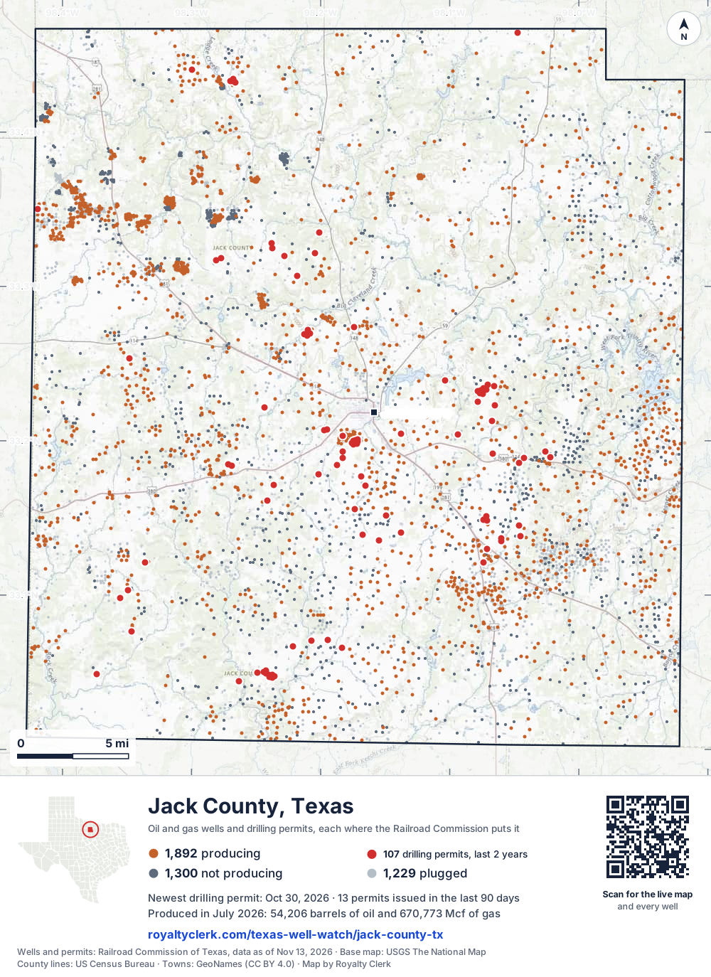
- Drilling locations107Permits issued in the last two years
- Producing wells1,892On a lease reporting production now
- Not producing1,300Shut in, inactive or no lease on record
- Plugged1,229The state's wellbore record says plugged
Sources: Railroad Commission of Texas well layers and permit files, US Census Bureau county outline, town points from GeoNames (CC BY 4.0), base map from USGS The National Map. A dot is a surface location; a horizontal well runs a mile or more from it.
4,421 wells with a location on the state's map and 107 drilling locations permitted in the last 24 months, each where the Railroad Commission puts it.
A permit is not a well.
Wells near each town in Jack County
Wells within 10 miles of each town, on either side of the county line.
Use this map on your site
You may show this map on any site, unchanged. Keep the credit line and its link to Royalty Clerk under the map. The picture updates by itself as the state records new wells and permits.
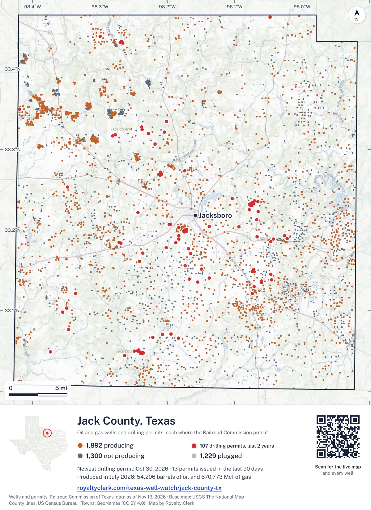
<a href="https://royaltyclerk.com/texas-well-watch/jack-county-tx"><img src="https://royaltyclerk.com/maps/county-wells/jack-county-tx.svg" alt="Map of Jack County, Texas, with 4,421 oil and gas wells and 107 recent drilling locations as dots." width="1000" height="1374" loading="lazy" style="max-width:100%;height:auto;border:0"></a>
<p style="margin:4px 0 0;font-size:14px">Map: <a href="https://royaltyclerk.com/texas-well-watch/jack-county-tx">Jack County, Texas oil and gas wells</a> by Royalty Clerk, from Railroad Commission of Texas records</p>
The last twelve months
Month by month in Jack County
| Month | Permits | Completions | First production |
|---|---|---|---|
| Oct 2026 | 7 | 1 | 0 |
| Sep 2026 | 4 | 4 | 0 |
| Aug 2026 | 3 | 6 | 1 |
| Jul 2026 | 6 | 4 | 1 |
| Jun 2026 | 1 | 3 | 2 |
| May 2026 | 4 | 5 | 1 |
| Apr 2026 | 5 | 3 | 2 |
| Mar 2026 | 5 | 3 | 6 |
| Feb 2026 | 4 | 2 | 1 |
| Jan 2026 | 8 | 4 | 1 |
| Dec 2025 | 1 | 6 | 4 |
| Nov 2025 | 1 | 1 | 0 |
Counted from November 15, 2025 to October 30, 2026, so the first and last months are partial. Source: Railroad Commission of Texas data sets.
Free, no sign-in
The newest drilling permits in Jack County
| Issued | Lease and well | Operator | Drilling began | Depth, ft | API number | Coordinates | Permit |
|---|---|---|---|---|---|---|---|
| 2026-10-30 | COCA COLA 14recompletion · verticalOakridge Oil and Gas, LPAPI 42-237-39335 · permit 091979533.20391, -98.093576,390 ft | Oakridge Oil and Gas, LP | |||||
| 2026-10-28 | HOUSE 2new drill · verticalClear Brooke Ranches, LLCAPI 42-237-40731 · permit 091964733.04905, -98.373335,100 ft | Clear Brooke Ranches, LLC | |||||
| 2026-10-19 | BROWN, LUPTON 8Sre-entry · verticalB.o.l.d. Oil and Gas, LLCAPI 42-237-02589 · permit 091918533.22513, -98.078522,400 ft | B.o.l.d. Oil and Gas, LLC | |||||
| 2026-10-09 | SEWELL A 2recompletion · verticalOakridge Oil and Gas, LPAPI 42-237-39267 · permit 091905133.17689, -98.168436,013 ft | Oakridge Oil and Gas, LP | |||||
| 2026-10-08 | SOUTH BRISCOE 8Cnew drill · verticalDRY Creek Operating, LLCAPI 42-237-40730 · permit 091901933.43264, -98.266425,300 ft | DRY Creek Operating, LLC | |||||
| 2026-10-07 | CHERRYHOMES, MIKE D 11recompletion · verticalOakridge Oil and Gas, LPAPI 42-237-38890 · permit 091903033.18878, -98.042676,355 ft | Oakridge Oil and Gas, LP | |||||
| 2026-10-05 | MYERS 1recompletion · verticalFX Energy Operating, LLCAPI 42-237-39716 · permit 091905333.32157, -98.204516,025 ft | FX Energy Operating, LLC | |||||
| 2026-09-14 | SIMPSON 1recompletion · verticalOakridge Oil and Gas, LPAPI 42-237-39636 · permit 091851133.18392, -98.269075,702 ft | Oakridge Oil and Gas, LP | |||||
| 2026-09-10 | CHERRYHOMES, MIKE D 43recompletion · verticalOakridge Oil and Gas, LPAPI 42-237-38969 · permit 091808433.19326, -98.025826,327 ft | Oakridge Oil and Gas, LP | |||||
| 2026-09-08 | BROWN, LUPTON 'B' O 1new drill · verticalOakridge Oil and Gas, LPAPI 42-237-40729 · permit 091838533.22284, -98.06515drilling began 2026-09-16 · 3,000 ft | Oakridge Oil and Gas, LP | |||||
| 2026-09-04 | PLASTER 1recompletion · verticalJLW Operations, LLCAPI 42-237-40691 · permit 091819933.20728, -98.195012,400 ft | JLW Operations, LLC | |||||
| 2026-08-27 | SOUTH BRISCOE 7Enew drill · verticalDRY Creek Operating, LLCAPI 42-237-40728 · permit 091814333.43306, -98.27007drilling began 2026-09-04 · 6,400 ft | DRY Creek Operating, LLC | |||||
| 2026-08-19 | STEWART, ORNEE 2recompletion · verticalBorderline Operating Corp.API 42-237-01794 · permit 091728733.23642, -98.070515,757 ft | Borderline Operating Corp. | |||||
| 2026-08-14 | WISE STEWART 9Snew drill · verticalB.o.l.d. Oil and Gas, LLCAPI 42-237-40727 · permit 091783633.23415, -98.073612,999 ft | B.o.l.d. Oil and Gas, LLC | |||||
| 2026-07-31 | SUTTON 1recompletion · verticalFX Energy Operating, LLCAPI 42-237-39637 · permit 091747533.16107, -98.241545,600 ft | FX Energy Operating, LLC | |||||
| 2026-07-22 | CHERRYHOMES, MIKE D 47recompletion · verticalOakridge Oil and Gas, LPAPI 42-237-38933 · permit 091728033.18926, -98.021846,622 ft | Oakridge Oil and Gas, LP | |||||
| 2026-07-21 | SIMPSON O 2new drill · verticalOakridge Oil and Gas, LPAPI 42-237-40726 · permit 091733033.18494, -98.27187drilling began 2026-08-11 · 4,999 ft | Oakridge Oil and Gas, LP | |||||
| 2026-07-10 | PARKER 2recompletion · verticalOakridge Oil and Gas, LPAPI 42-237-39402 · permit 091710233.06609, -98.183575,910 ft | Oakridge Oil and Gas, LP | |||||
| 2026-07-10 | RICHARDS RANCH O 4recompletion · verticalOakridge Oil and Gas, LPAPI 42-237-40662 · permit 091708433.19944, -98.171222,099 ft | Oakridge Oil and Gas, LP | |||||
| 2026-07-10 | PARKER O 4new drill · verticalOakridge Oil and Gas, LPAPI 42-237-40725 · permit 091700133.07083, -98.19469drilling began 2026-07-27 · 3,000 ft | Oakridge Oil and Gas, LP | |||||
| 2026-06-10 | DAVIS 'D' 4new drill · verticalPop Operating CompanyAPI 42-237-40724 · permit 091629733.35029, -98.41927drilling began 2026-08-02 · 3,700 ft | Pop Operating Company | |||||
| 2026-05-27 | PLASTER 2new drill · verticalJLW Operations, LLCAPI 42-237-40723 · permit 091580433.20684, -98.19703drilling began 2026-06-23 · 1,999 ft | JLW Operations, LLC | |||||
| 2026-05-19 | WISE STEWART 7Snew drill · verticalB.o.l.d. Oil and Gas, LLCAPI 42-237-40722 · permit 091552333.23319, -98.07168drilling began 2026-06-04 · 2,999 ft | B.o.l.d. Oil and Gas, LLC | |||||
| 2026-05-13 | LARRY MCCLURE 1new drill · verticalB.o.l.d. Oil and Gas, LLCAPI 42-237-40721 · permit 091554733.23893, -98.103802,999 ft | B.o.l.d. Oil and Gas, LLC | |||||
| 2026-05-01 | MESA BRISCOE LUCKY 7Hnew drill · horizontalG & F Oil, Inc.API 42-237-40720 · permit 091521833.43303, -98.26881drilling began 2026-05-25 · 6,000 ft | G & F Oil, Inc. | |||||
| 2026-04-21 | R. L. MARTIN O 12new drill · verticalOakridge Oil and Gas, LPAPI 42-237-40718 · permit 091485333.04975, -98.24894drilling began 2026-06-23 · 3,000 ft | Oakridge Oil and Gas, LP | |||||
| 2026-04-14 | TEAGUE 1re-entry · verticalOakridge Oil and Gas, LPAPI 42-237-39723 · permit 091456633.04428, -98.26313drilling began 2013-05-29 · 3,000 ft | Oakridge Oil and Gas, LP | |||||
| 2026-04-13 | SOUTH BRISCOE 6Pnew drill · verticalDRY Creek Operating, LLCAPI 42-237-40716 · permit 091473233.43452, -98.26791drilling began 2026-05-26 · 2,200 ft | DRY Creek Operating, LLC | |||||
| 2026-04-13 | SOUTH BRISCOE 5Crecompletion · verticalDRY Creek Operating, LLCAPI 42-237-40717 · permit 091474233.43208, -98.26628drilling began 2026-08-01 · 6,400 ft | DRY Creek Operating, LLC | |||||
| 2026-04-06 | GARDNER 1recompletion · verticalFX Energy Operating, LLCAPI 42-237-40382 · permit 091452833.33491, -98.200925,955 ft | FX Energy Operating, LLC | |||||
| 2026-03-31 | HUGHES 1Hreclass · horizontalFX Energy Operating, LLCAPI 42-237-39489 · permit 091430233.06688, -98.221685,174 ft | FX Energy Operating, LLC | |||||
| 2026-03-27 | BEALL 1new drill · verticalWillowbend Investments, Inc.API 42-237-40715 · permit 091434833.07626, -98.34635drilling began 2026-04-08 · 4,999 ft | Willowbend Investments, Inc. | |||||
| 2026-03-26 | BRISCOE 2recompletion · verticalCaribou Operating, Inc.API 42-237-40383 · permit 091434533.44031, -98.29985drilling began 2025-09-21 · 6,500 ft | Caribou Operating, Inc. | |||||
| 2026-03-24 | HENDERSON O 2new drill · verticalOakridge Oil and Gas, LPAPI 42-237-40714 · permit 091428833.31683, -98.281173,000 ft | Oakridge Oil and Gas, LP | |||||
| 2026-03-20 | HENDERSON O 1new drill · verticalOakridge Oil and Gas, LPAPI 42-237-40713 · permit 091425833.31843, -98.27733drilling began 2026-03-30 · 3,000 ft | Oakridge Oil and Gas, LP | |||||
| 2026-02-26 | R. L. MARTIN O 11new drill · verticalOakridge Oil and Gas, LPAPI 42-237-40712 · permit 091369533.05124, -98.242393,000 ft | Oakridge Oil and Gas, LP | |||||
| 2026-02-26 | R. L. MARTIN O 10new drill · verticalOakridge Oil and Gas, LPAPI 42-237-40711 · permit 091369433.05027, -98.24423drilling began 2026-03-02 · 3,000 ft | Oakridge Oil and Gas, LP | |||||
| 2026-02-13 | R. L. MARTIN O 9new drill · verticalOakridge Oil and Gas, LPAPI 42-237-40710 · permit 091341033.04941, -98.24231drilling began 2026-02-17 · 3,000 ft | Oakridge Oil and Gas, LP | |||||
| 2026-02-02 | RICHARDS RANCH W 51recompletion · verticalFX Energy Operating, LLCAPI 42-237-40498 · permit 091308133.20305, -98.182845,851 ft | FX Energy Operating, LLC | |||||
| 2026-01-26 | MCCLURE NORTH 7recompletion · verticalFX Energy Operating, LLCAPI 42-237-40112 · permit 091272633.20449, -98.137976,355 ft | FX Energy Operating, LLC | |||||
| 2026-01-22 | RICHARDS RANCH N 25recompletion · verticalFX Energy Operating, LLCAPI 42-237-40030 · permit 091300833.18885, -98.18273drilling began 2014-06-29 · 6,095 ft | FX Energy Operating, LLC | |||||
| 2026-01-21 | R. L. MARTIN O 8new drill · verticalOakridge Oil and Gas, LPAPI 42-237-40709 · permit 091298433.04738, -98.23562drilling began 2026-02-09 · 3,000 ft | Oakridge Oil and Gas, LP | |||||
| 2026-01-21 | R. L. MARTIN O 7new drill · verticalOakridge Oil and Gas, LPAPI 42-237-40708 · permit 091298333.04642, -98.23747drilling began 2026-02-01 · 3,000 ft | Oakridge Oil and Gas, LP | |||||
| 2026-01-14 | BROWN, LUPTON 6Snew drill · verticalBorderline Operating Corp.API 42-237-40707 · permit 091259633.23058, -98.074362,999 ft | Borderline Operating Corp. | |||||
| 2026-01-14 | BROWN, LUPTON 4Snew drill · verticalBorderline Operating Corp.API 42-237-40706 · permit 091258933.23090, -98.07649drilling began 2026-02-02 · 2,999 ft | Borderline Operating Corp. | |||||
| 2026-01-13 | R. L. MARTIN O 6new drill · verticalOakridge Oil and Gas, LPAPI 42-237-40705 · permit 091266633.04854, -98.24040drilling began 2026-01-14 · 3,000 ft | Oakridge Oil and Gas, LP | |||||
| 2026-01-08 | R. L. MARTIN O 4re-entry · verticalOakridge Oil and Gas, LPAPI 42-237-40702 · permit 091248533.04685, -98.23956drilling began 2026-01-09 · 3,000 ft | Oakridge Oil and Gas, LP | |||||
| 2025-12-12 | JACKSBORO, S. (1975) UNIT 35new drill · verticalPecos Valley Operating Inc.API 42-237-40704 · permit 091213733.20107, -98.17158drilling began 2026-02-02 · 2,100 ft | Pecos Valley Operating Inc. | |||||
| 2025-11-17 | R. L. MARTIN O 5new drill · verticalOakridge Oil and Gas, LPAPI 42-237-40703 · permit 091178233.04824, -98.23754drilling began 2025-11-18 · 3,000 ft | Oakridge Oil and Gas, LP | |||||
| 2025-11-14 | RICHARDS RANCH N 19recompletion · verticalFX Energy Operating, LLCAPI 42-237-40029 · permit 091166033.19309, -98.182686,095 ft | FX Energy Operating, LLC |
These are the newest 50 of 152 permits on file for Jack County. The rest follow, 50 to a page.
A permit is permission to drill, not a well. Source: Railroad Commission of Texas drilling permit files.
Year by year
Drilling permits issued in Jack County, by year
| Year | Permits issued |
|---|---|
| 2026 so far | 47 |
| 2025 | 50 |
| 2024 | 38 |
| 2023 | 12 |
| 2020 | 1 |
| 2014 | 1 |
| 2013 | 1 |
| 2012 | 1 |
| 2011 | 1 |
Counted from the permit files we hold, which start in 2011; that first year may be partial. Source: Railroad Commission of Texas drilling permit files.
The latest
The most recent records
| Date | What, who and where |
|---|---|
| 2026-10-30 | Permit issued: Oakridge Oil and Gas, LPCOCA COLA · A-223 · permit 0919795 |
| 2026-10-28 | Permit issued: Clear Brooke Ranches, LLCHOUSE · A-350 · permit 0919647 |
| 2026-10-19 | Permit issued: B.o.l.d. Oil and Gas, LLCBROWN, LUPTON · A-358 · permit 0919185 |
| 2026-10-09 | Permit issued: Oakridge Oil and Gas, LPSEWELL A · A-278 · permit 0919051 |
| 2026-10-08 | Completed: DRY Creek Operating, LLCSOUTH BRISCOE · A-380 · permit 0918143 |
| 2026-10-08 | Permit issued: DRY Creek Operating, LLCSOUTH BRISCOE · A-380 · permit 0919019 |
| 2026-10-07 | Permit issued: Oakridge Oil and Gas, LPCHERRYHOMES, MIKE · A-1106 · permit 0919030 |
| 2026-10-05 | Permit issued: FX Energy Operating, LLCMYERS · A-1592 · permit 0919053 |
| 2026-09-14 | Permit issued: Oakridge Oil and Gas, LPSIMPSON · A-11 · permit 0918511 |
| 2026-09-12 | Completed: FX Energy Operating, LLCRICHARDS RANCH · A-254 · permit 0911621 |
| 2026-09-10 | Completed: Oakridge Oil and Gas, LPCHERRYHOMES "Y" · A-251 |
| 2026-09-10 | Permit issued: Oakridge Oil and Gas, LPCHERRYHOMES, MIKE · A-1073 · permit 0918084 |
| 2026-09-08 | Permit issued: Oakridge Oil and Gas, LPBROWN, LUPTON 'B' · A-52 · permit 0918385 |
| 2026-09-07 | Completed: JLW Operations, LLCPLASTER · A-43 · permit 0918199 |
| 2026-09-04 | Permit issued: JLW Operations, LLCPLASTER · A-43 · permit 0918199 |
Coming up
First checks coming due in Jack County
- WORTHINGTON, Oakridge Oil and Gas, LPby November 28, 2026
- STEWART, ORNEE, Borderline Operating Corp.by November 28, 2026
- Beall, Willowbend Investments, Inc.by November 28, 2026
- CHERRYHOMES, MIKE, Oakridge Oil and Gas, LPby December 29, 2026
- Cherryhomes, Mike, Oakridge Oil and Gas, LPby December 29, 2026
- PARKER, Oakridge Oil and Gas, LPby December 29, 2026
- CLAYTON RANCH C, Oakridge Oil and Gas, LPby December 29, 2026
- RICHARDS RANCH, FX Energy Operating, LLCby January 28, 2027
Follow it
Watch Jack County, or one abstract
What do you want to follow?
Where the land is. Your deed or lease names it.
For example A-1119, or Bush, or T&P 38. Your deed or the tax bill has it.
Other counties
Drilling activity in other counties
Related
Related
- ToolTexas well watchPermit, completion, first production and when the first check is due.
- ToolIs this buyout offer fair?The offer as months of your income, what the acres mean, and the questions to ask.
- ToolIs this lease offer good?Bonus and royalty against the county, and a scan of the lease's clauses.
- Texas dataTexas operator changesWho took over whose leases in the last 24 months.
- ToolLate payment interestDeadlines and the interest a late payment earns.
- Texas dataTexas oil and gas atlas254 counties, every lease, operator and field.
FAQ
Questions people ask
How many wells were permitted in Jack County in the last year?
The Railroad Commission issued 49 drilling permits in Jack County in the twelve months to October 30, 2026, and recorded 42 completions and 19 first-production reports. A permit is permission to drill, not a well.
How do I get an alert when a permit is issued near my land in Jack County?
Choose your abstract on this page, or the whole county, and sign in. You get one email a week, only when something new is recorded after you sign up. The alert says whether an event is on an interest in your Mineral File, on a place you follow, or only nearby.
When is my first royalty check due after a new well?
Natural Resources Code section 91.402(a) says on or before 120 days after the end of the month of first sale of production from the well. The state's first-production month is the closest public marker, so the date on this page is the earliest, not a certainty.
Got a new well on your land?
The first check is due within 120 days after the end of the month of first sale.
Sources
Primary sources, opened on 29 September 2026. Statute text is the current version on statutes.capitol.texas.gov.