
Jackson County, Texas
Jackson County drilling permits: what the state recorded
- 7drilling permits
- 16completions
- 1first-production report
- in the last twelve months
Wells by coordinates
Oil wells and drilling locations in Jackson County
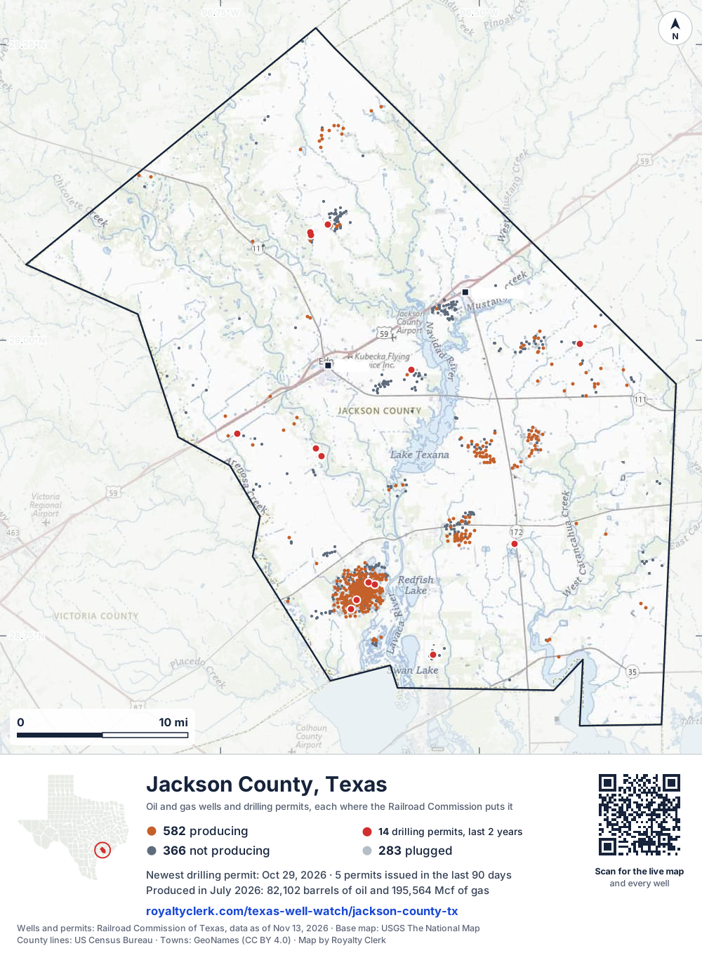
- Drilling locations14Permits issued in the last two years
- Producing wells582On a lease reporting production now
- Not producing366Shut in, inactive or no lease on record
- Plugged283The state's wellbore record says plugged
Sources: Railroad Commission of Texas well layers and permit files, US Census Bureau county outline, town points from GeoNames (CC BY 4.0), base map from USGS The National Map. A dot is a surface location; a horizontal well runs a mile or more from it.
1,231 wells with a location on the state's map and 14 drilling locations permitted in the last 24 months, each where the Railroad Commission puts it.
A permit is not a well.
Wells near each town in Jackson County
Wells within 10 miles of each town, on either side of the county line.
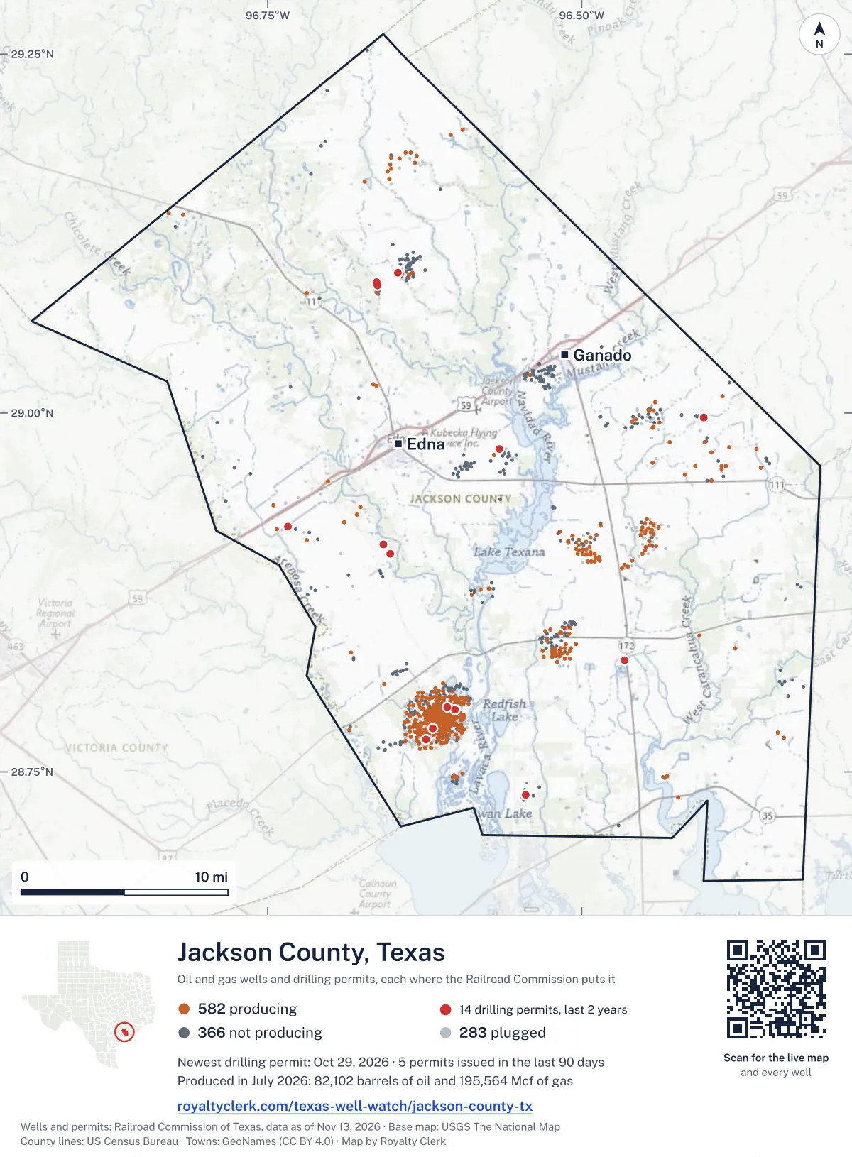
Use this map on your site
You may show this map on any site, unchanged. Keep the credit line and its link to Royalty Clerk under the map. The picture updates by itself as the state records new wells and permits.
<a href="https://royaltyclerk.com/texas-well-watch/jackson-county-tx"><img src="https://royaltyclerk.com/maps/county-wells/jackson-county-tx.svg" alt="Map of Jackson County, Texas, with 1,231 oil and gas wells and 14 recent drilling locations as dots." width="1000" height="1358" loading="lazy" style="max-width:100%;height:auto;border:0"></a>
<p style="margin:4px 0 0;font-size:14px">Map: <a href="https://royaltyclerk.com/texas-well-watch/jackson-county-tx">Jackson County, Texas oil and gas wells</a> by Royalty Clerk, from Railroad Commission of Texas records</p>
The last twelve months
Month by month in Jackson County
| Month | Permits | Completions | First production |
|---|---|---|---|
| Oct 2026 | 2 | 0 | 0 |
| Sep 2026 | 3 | 1 | 0 |
| Aug 2026 | 0 | 1 | 0 |
| Jul 2026 | 0 | 2 | 0 |
| May 2026 | 0 | 3 | 0 |
| Apr 2026 | 0 | 1 | 0 |
| Mar 2026 | 0 | 2 | 1 |
| Feb 2026 | 0 | 1 | 0 |
| Jan 2026 | 0 | 5 | 0 |
| Dec 2025 | 2 | 0 | 0 |
Counted from November 16, 2025 to October 29, 2026, so the first and last months are partial. Source: Railroad Commission of Texas data sets.
Free, no sign-in
The newest drilling permits in Jackson County
| Issued | Lease and well | Operator | Drilling began | Depth, ft | API number | Coordinates | Permit |
|---|---|---|---|---|---|---|---|
| 2026-10-29 | BROOKING, G.T. 45recompletion · verticalBritnic Oil & Gas, Inc.API 42-239-33451 · permit 091954928.73390, -96.544327,637 ft | Britnic Oil & Gas, Inc. | |||||
| 2026-10-16 | WEST RANCH (41-A/98-A CONS) UNIT 2193recompletion · verticalHilcorp Energy CompanyAPI 42-239-33833 · permit 091921528.79355, -96.60072drilling began 2025-08-20 · 7,200 ft | Hilcorp Energy Company | |||||
| 2026-09-21 | WEST RANCH A 2075recompletion · verticalHilcorp Energy CompanyAPI 42-239-33804 · permit 091871828.77256, -96.623896,474 ft | Hilcorp Energy Company | |||||
| 2026-09-21 | WEST RANCH A 600recompletion · verticalHilcorp Energy CompanyAPI 42-239-33580 · permit 091870828.79492, -96.606756,500 ft | Hilcorp Energy Company | |||||
| 2026-09-16 | STAFFORD UNIT 1new drill · verticalKaler Energy Corp.API 42-239-33972 · permit 091864528.92082, -96.7341811,500 ft | Kaler Energy Corp. | |||||
| 2025-12-23 | LORENZEN 2new drill · verticalPaloma Operating, LLCAPI 42-239-33971 · permit 091239428.90166, -96.65247drilling began 2026-01-10 · 6,900 ft | Paloma Operating, LLC | |||||
| 2025-12-15 | YAUSSI B X 1new drill · verticalOxbow Ep LLCAPI 42-239-33970 · permit 091207729.09099, -96.66363drilling began 2025-12-16 · 6,300 ft | Oxbow Ep LLC | |||||
| 2025-09-18 | L RANCH D UNIT 1Arecompletion · verticalWagner Oil CompanyAPI 42-239-33436 · permit 091033428.82761, -96.466018,600 ft | Wagner Oil Company | |||||
| 2025-08-21 | HESS 2Are-entry · verticalMamerow Energy CorpAPI 42-239-31455 · permit 090993928.99693, -96.402866,718 ft | Mamerow Energy Corp | |||||
| 2025-08-08 | MAUDE K. HILLYER 2recompletion · verticalBeard Oil Company, LLCAPI 42-239-01645 · permit 090971328.97473, -96.565806,815 ft | Beard Oil Company, LLC | |||||
| 2025-03-25 | ROSE-SAMPLE 2re-entry · verticalStone Edge Energy, LLCAPI 42-239-32434 · permit 090636029.09749, -96.646412,800 ft | Stone Edge Energy, LLC | |||||
| 2025-03-21 | LORENZEN 1recompletion · verticalPaloma Operating, LLCAPI 42-239-33944 · permit 090679328.90833, -96.65820drilling began 2021-01-08 · 6,805 ft | Paloma Operating, LLC | |||||
| 2024-12-10 | WEST RANCH (41-A/98-A CONS) UNIT 1044recompletion · verticalHilcorp Energy CompanyAPI 42-239-33723 · permit 090435628.78005, -96.61870drilling began 2024-10-30 · 6,494 ft | Hilcorp Energy Company | |||||
| 2024-12-04 | YAUSSI B 101new drill · verticalOxbow Ep LLCAPI 42-239-33969 · permit 090442729.08881, -96.66233drilling began 2024-12-07 · 3,500 ft | Oxbow Ep LLC | |||||
| 2024-11-13 | WEST RANCH -A- 439recompletion · verticalHilcorp Energy CompanyAPI 42-239-02785 · permit 090390628.76957, -96.623567,810 ft | Hilcorp Energy Company | |||||
| 2024-10-22 | WEST RANCH -A- 1109recompletion · verticalHilcorp Energy CompanyAPI 42-239-33887 · permit 090341528.77117, -96.630506,482 ft | Hilcorp Energy Company | |||||
| 2024-09-30 | WEST RANCH (41-A/98-A CONS) UNIT 326recompletion · verticalHilcorp Energy CompanyAPI 42-239-02674 · permit 090283828.80209, -96.60503drilling began 2024-05-22 · 6,500 ft | Hilcorp Energy Company | |||||
| 2024-09-26 | WEST RANCH -A- 503recompletion · verticalHilcorp Energy CompanyAPI 42-239-32014 · permit 090283928.77661, -96.623558,251 ft | Hilcorp Energy Company | |||||
| 2024-09-20 | WEST RANCH (41-A/98-A CONS) UNIT 1107reclass · verticalHilcorp Energy CompanyAPI 42-239-33799 · permit 090275528.77568, -96.627876,470 ft | Hilcorp Energy Company | |||||
| 2024-09-18 | WEST RANCH (41-A/98-A CONS) UNIT 1071reclass · verticalHilcorp Energy CompanyAPI 42-239-33709 · permit 090272528.79468, -96.61701drilling began 2024-03-25 · 6,485 ft | Hilcorp Energy Company | |||||
| 2024-09-11 | DRUMMOND, J.H. A 2recompletion · verticalHilcorp Energy CompanyAPI 42-239-33576 · permit 090254928.80440, -96.616039,000 ft | Hilcorp Energy Company | |||||
| 2024-08-09 | ROBBINS 7recompletion · verticalHG Operating LLCAPI 42-239-33588 · permit 090128528.93383, -96.522657,445 ft | HG Operating LLC | |||||
| 2024-07-18 | WEST RANCH (41-A/98-A CONS) UNIT 1110reclass · verticalHilcorp Energy CompanyAPI 42-239-33757 · permit 090120228.77662, -96.62189drilling began 2024-04-02 · 6,505 ft | Hilcorp Energy Company | |||||
| 2024-06-28 | WEST RANCH (41-A/98-A CONS) UNIT 1065reclass · verticalHilcorp Energy CompanyAPI 42-239-33706 · permit 090074228.78727, -96.62366drilling began 2024-05-01 · 6,500 ft | Hilcorp Energy Company | |||||
| 2024-06-05 | WEST RANCH (41-A/98-A CONS) UNIT 1046reclass · verticalHilcorp Energy CompanyAPI 42-239-33754 · permit 090011428.77968, -96.62449drilling began 2024-03-21 · 6,489 ft | Hilcorp Energy Company | |||||
| 2024-06-05 | WEST RANCH (41-A/98-A CONS) UNIT 1019reclass · verticalHilcorp Energy CompanyAPI 42-239-33687 · permit 090002828.78545, -96.61531drilling began 2024-04-16 · 6,401 ft | Hilcorp Energy Company | |||||
| 2024-05-31 | WEST RANCH -A- 1123recompletion · verticalHilcorp Energy CompanyAPI 42-239-33903 · permit 090002728.78311, -96.60084drilling began 2024-03-05 · 6,444 ft | Hilcorp Energy Company | |||||
| 2024-05-20 | JOHN MACHYCEK 2re-entry · verticalMamerow Energy CorpAPI 42-239-00722 · permit 089853729.00200, -96.387015,850 ft | Mamerow Energy Corp | |||||
| 2024-02-07 | TEXANA 1new drill · verticalKaler Energy Corp.API 42-239-33968 · permit 089709729.03743, -96.6015310,000 ft | Kaler Energy Corp. | |||||
| 2024-01-30 | WEST RANCH (41-A/98-A CONS) UNIT 1069reclass · verticalHilcorp Energy CompanyAPI 42-239-33707 · permit 089685428.79694, -96.61275drilling began 2023-12-18 · 6,438 ft | Hilcorp Energy Company | |||||
| 2024-01-12 | WEST RANCH -A- 378recompletion · verticalHilcorp Energy CompanyAPI 42-239-02725 · permit 089644828.78244, -96.60698drilling began 2023-11-22 · 6,303 ft | Hilcorp Energy Company | |||||
| 2023-12-15 | WEST RANCH -A- 508recompletion · verticalHilcorp Energy CompanyAPI 42-239-32010 · permit 089596128.78412, -96.60023drilling began 2023-11-20 · 6,500 ft | Hilcorp Energy Company | |||||
| 2023-11-15 | WEST RANCH -A- 394recompletion · verticalHilcorp Energy CompanyAPI 42-239-02741 · permit 089514928.78801, -96.60795drilling began 2023-10-25 · 5,854 ft | Hilcorp Energy Company | |||||
| 2023-10-23 | WEST RANCH -A- 127recompletion · verticalHilcorp Energy CompanyAPI 42-239-02482 · permit 089472028.78282, -96.60182drilling began 2023-10-09 · 5,819 ft | Hilcorp Energy Company | |||||
| 2023-10-23 | WEST RANCH -A- 602recompletion · verticalHilcorp Energy CompanyAPI 42-239-33586 · permit 089471128.79354, -96.60550drilling began 2023-10-16 · 6,553 ft | Hilcorp Energy Company | |||||
| 2023-10-02 | DRUMMOND, J.H. 3Mrecompletion · verticalHilcorp Energy CompanyAPI 42-239-33569 · permit 089404128.80617, -96.61399drilling began 2023-10-12 · 8,007 ft | Hilcorp Energy Company | |||||
| 2021-04-16 | STRICKLER 2new drill · verticalZeppe Petroleum, LLCAPI 42-239-33945 · permit 086533828.99249, -96.47934drilling began 2023-03-16 · 6,500 ft | Zeppe Petroleum, LLC |
A permit is permission to drill, not a well. Source: Railroad Commission of Texas drilling permit files.
Year by year
Drilling permits issued in Jackson County, by year
| Year | Permits issued |
|---|---|
| 2026 so far | 5 |
| 2025 | 7 |
| 2024 | 19 |
| 2023 | 5 |
| 2021 | 1 |
Counted from the permit files we hold, which start in 2021; that first year may be partial. Source: Railroad Commission of Texas drilling permit files.
The latest
The most recent records
| Date | What, who and where |
|---|---|
| 2026-10-29 | Permit issued: Britnic Oil & Gas, Inc.BROOKING, G.T. · A-7 · permit 0919549 |
| 2026-10-16 | Permit issued: Hilcorp Energy CompanyWEST RANCH (41-A/98-A CONS) UNIT · A-59 · permit 0919215 |
| 2026-09-21 | Permit issued: Hilcorp Energy CompanyWEST RANCH A · A-59 · permit 0918718 |
| 2026-09-21 | Permit issued: Hilcorp Energy CompanyWEST RANCH A · A-59 · permit 0918708 |
| 2026-09-16 | Permit issued: Kaler Energy Corp.STAFFORD UNIT · A-21 · permit 0918645 |
| 2026-09-14 | Completed: Mamerow Energy CorpHESS · A-357 · permit 0909939 |
| 2026-08-08 | Completed: Hilcorp Energy CompanyWEST RANCH (41-A/98-A CONS) UNIT · A-59 · permit 0902755 |
| 2026-07-10 | Completed: Hilcorp Energy CompanyWEST RANCH (41-A/98-A CONS) UNIT · A-24 |
| 2026-07-10 | Completed: Hilcorp Energy CompanyWEST RANCH (41-A/98-A CONS) UNIT · A-24 |
| 2026-05-29 | Completed: Hilcorp Energy CompanyWEST RANCH (41-A/98-A CONS) UNIT · A-59 |
| 2026-05-07 | Completed: McGowan Working Partners, Inc.JOHNSON, ELMER · A-149 |
| 2026-05-06 | CompletedA-7 |
| 2026-04-10 | Completed: Hilcorp Energy CompanyWEST RANCH (41-A/98-A CONS) UNIT · A-59 |
| 2026-03-24 | Completed: Hilcorp Energy CompanyWEST RANCH (41-A/98-A CONS) UNIT · A-59 |
| 2026-03-20 | Completed: Paloma Operating, LLCLORENZEN · A-213 · permit 0912394 |
Coming up
First checks coming due in Jackson County
- WEST RANCH (41-A/98-A CONS) UNIT, Hilcorp Energy Companyby November 28, 2026
- WEST RANCH (41-A/98-A CONS) UNIT, Hilcorp Energy Companyby November 28, 2026
Follow it
Watch Jackson County, or one abstract
What do you want to follow?
Where the land is. Your deed or lease names it.
For example A-1119, or Bush, or T&P 38. Your deed or the tax bill has it.
Other counties
Drilling activity in other counties
Related
Related
- ToolTexas well watchPermit, completion, first production and when the first check is due.
- ToolIs this buyout offer fair?The offer as months of your income, what the acres mean, and the questions to ask.
- ToolIs this lease offer good?Bonus and royalty against the county, and a scan of the lease's clauses.
- Texas dataTexas operator changesWho took over whose leases in the last 24 months.
- ToolLate payment interestDeadlines and the interest a late payment earns.
- Texas dataTexas oil and gas atlas254 counties, every lease, operator and field.
FAQ
Questions people ask
How many wells were permitted in Jackson County in the last year?
The Railroad Commission issued 7 drilling permits in Jackson County in the twelve months to October 29, 2026, and recorded 16 completions and 1 first-production report. A permit is permission to drill, not a well.
How do I get an alert when a permit is issued near my land in Jackson County?
Choose your abstract on this page, or the whole county, and sign in. You get one email a week, only when something new is recorded after you sign up. The alert says whether an event is on an interest in your Mineral File, on a place you follow, or only nearby.
When is my first royalty check due after a new well?
Natural Resources Code section 91.402(a) says on or before 120 days after the end of the month of first sale of production from the well. The state's first-production month is the closest public marker, so the date on this page is the earliest, not a certainty.
Got a new well on your land?
The first check is due within 120 days after the end of the month of first sale.
Sources
Primary sources, opened on 29 September 2026. Statute text is the current version on statutes.capitol.texas.gov.