
Kent County, Texas
Kent County drilling permits: what the state recorded
- 10drilling permits
- 14completions
- 0first-production reports
- in the last twelve months
Wells by coordinates
Oil wells and drilling locations in Kent County
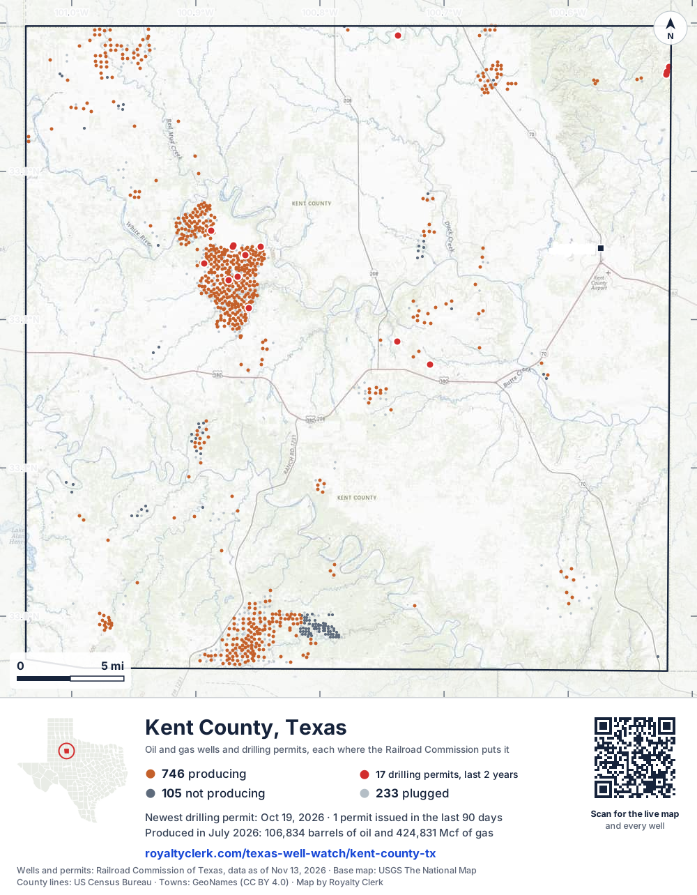
- Drilling locations17Permits issued in the last two years
- Producing wells746On a lease reporting production now
- Not producing105Shut in, inactive or no lease on record
- Plugged233The state's wellbore record says plugged
Sources: Railroad Commission of Texas well layers and permit files, US Census Bureau county outline, town points from GeoNames (CC BY 4.0), base map from USGS The National Map. A dot is a surface location; a horizontal well runs a mile or more from it.
1,084 wells with a location on the state's map and 17 drilling locations permitted in the last 24 months, each where the Railroad Commission puts it.
A permit is not a well.
Wells near each town in Kent County
Wells within 10 miles of each town, on either side of the county line.
Use this map on your site
You may show this map on any site, unchanged. Keep the credit line and its link to Royalty Clerk under the map. The picture updates by itself as the state records new wells and permits.
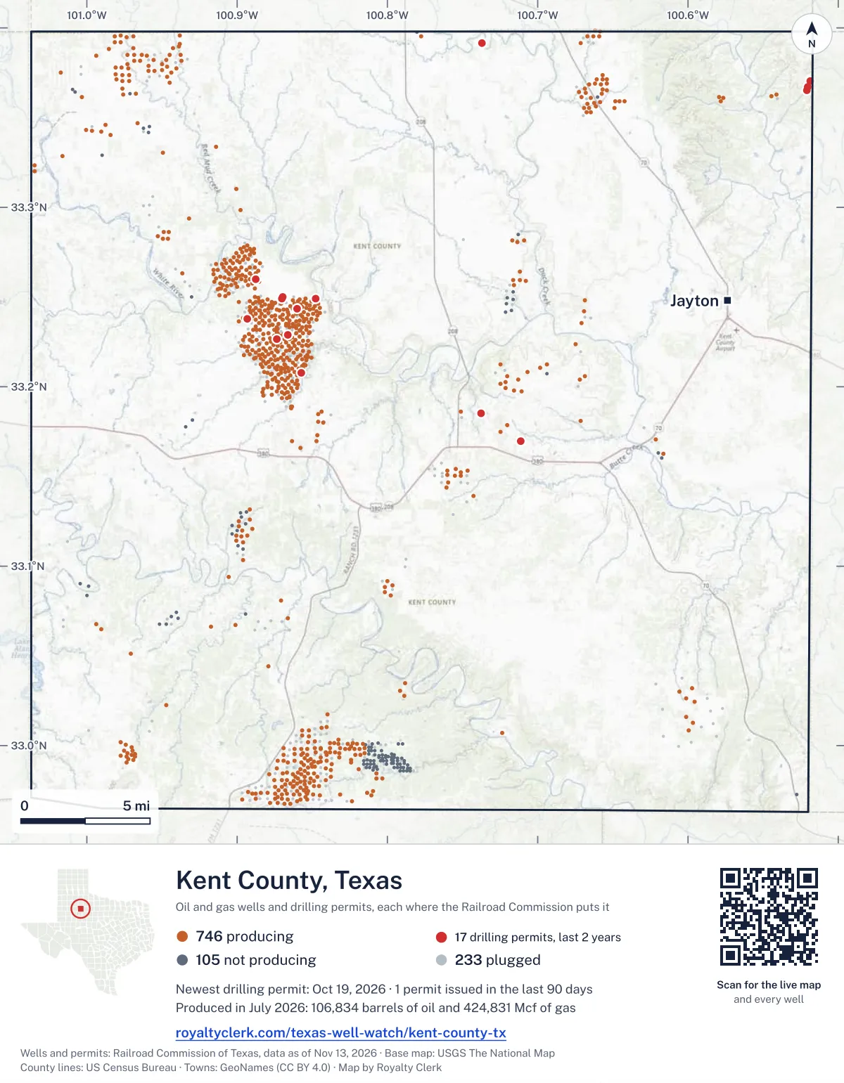
<a href="https://royaltyclerk.com/texas-well-watch/kent-county-tx"><img src="https://royaltyclerk.com/maps/county-wells/kent-county-tx.svg" alt="Map of Kent County, Texas, with 1,084 oil and gas wells and 17 recent drilling locations as dots." width="1000" height="1284" loading="lazy" style="max-width:100%;height:auto;border:0"></a>
<p style="margin:4px 0 0;font-size:14px">Map: <a href="https://royaltyclerk.com/texas-well-watch/kent-county-tx">Kent County, Texas oil and gas wells</a> by Royalty Clerk, from Railroad Commission of Texas records</p>
The last twelve months
Month by month in Kent County
| Month | Permits | Completions | First production |
|---|---|---|---|
| Oct 2026 | 1 | 0 | 0 |
| Jul 2026 | 1 | 0 | 0 |
| Jun 2026 | 1 | 0 | 0 |
| May 2026 | 1 | 0 | 0 |
| Apr 2026 | 5 | 0 | 0 |
| Mar 2026 | 0 | 5 | 0 |
| Feb 2026 | 1 | 6 | 0 |
| Jan 2026 | 0 | 1 | 0 |
| Dec 2025 | 0 | 1 | 0 |
| Nov 2025 | 0 | 1 | 0 |
Counted from November 17, 2025 to October 19, 2026, so the first and last months are partial. Source: Railroad Commission of Texas data sets.
Free, no sign-in
The newest drilling permits in Kent County
| Issued | Lease and well | Operator | Drilling began | Depth, ft | API number | Coordinates | Permit |
|---|---|---|---|---|---|---|---|
| 2026-10-19 | HOT SPRINGS 5new drill · verticalSojourner Drilling CorporationAPI 42-263-32184 · permit 091904533.37027, -100.518754,500 ft | Sojourner Drilling Corporation | |||||
| 2026-07-23 | BEADLE 1Anew drill · verticalSalida Exploration, LLCAPI 42-263-32183 · permit 091689333.39150, -100.73730drilling began 2026-07-26 · 5,000 ft | Salida Exploration, LLC | |||||
| 2026-06-03 | SALT CREEK FIELD UNIT F043recompletion · horizontalOXY USA WTP LPAPI 42-263-32154 · permit 091601233.24902, -100.847637,200 ft | OXY USA WTP LP | |||||
| 2026-05-07 | MOLLY 3501new drill · verticalCanan Mowrey Operating, LLCAPI 42-263-32182 · permit 091531133.16950, -100.71120drilling began 2026-07-01 · 7,200 ft | Canan Mowrey Operating, LLC | |||||
| 2026-04-29 | BRYNN 2101new drill · verticalCanan Mowrey Operating, LLCAPI 42-263-32181 · permit 091520433.18519, -100.73790drilling began 2026-06-12 · 7,200 ft | Canan Mowrey Operating, LLC | |||||
| 2026-04-24 | SALT CREEK FIELD UNIT N049Arecompletion · horizontalOXY USA WTP LPAPI 42-263-32023 · permit 091504733.23762, -100.893067,200 ft | OXY USA WTP LP | |||||
| 2026-04-08 | SALT CREEK FIELD UNIT F615recompletion · verticalOXY USA WTP LPAPI 42-263-31510 · permit 091453933.25975, -100.887787,000 ft | OXY USA WTP LP | |||||
| 2026-04-02 | SALT CREEK FIELD UNIT H610recompletion · verticalOXY USA WTP LPAPI 42-263-31279 · permit 091451133.22656, -100.873369,000 ft | OXY USA WTP LP | |||||
| 2026-04-02 | SALT CREEK FIELD UNIT F215recompletion · verticalOXY USA WTP LPAPI 42-263-31183 · permit 091450733.24358, -100.860069,000 ft | OXY USA WTP LP | |||||
| 2026-02-09 | SALT CREEK FIELD UNIT F 11recompletion · verticalOXY USA WTP LPAPI 42-263-00227 · permit 091330033.24984, -100.869789,000 ft | OXY USA WTP LP | |||||
| 2025-10-22 | SALT CREEK FIELD UNIT E340Wnew drill · verticalOXY USA WTP LPAPI 42-263-32179 · permit 091117533.24920, -100.87023drilling began 2026-01-10 · 7,000 ft | OXY USA WTP LP | |||||
| 2025-10-22 | SALT CREEK FIELD UNIT E339Wnew drill · verticalOXY USA WTP LPAPI 42-263-32178 · permit 091117433.24920, -100.87034drilling began 2026-01-11 · 7,000 ft | OXY USA WTP LP | |||||
| 2025-10-22 | SALT CREEK FIELD UNIT E338new drill · verticalOXY USA WTP LPAPI 42-263-32177 · permit 091117333.24920, -100.870467,000 ft | OXY USA WTP LP | |||||
| 2025-10-16 | SALT CREEK FIELD UNIT C443new drill · verticalOXY USA WTP LPAPI 42-263-32180 · permit 091116833.20775, -100.85729drilling began 2025-12-17 · 7,000 ft | OXY USA WTP LP | |||||
| 2025-10-13 | HOT SPRINGS 3new drill · verticalSojourner Drilling CorporationAPI 42-263-32175 · permit 091048233.36517, -100.52099drilling began 2025-12-15 · 4,500 ft | Sojourner Drilling Corporation | |||||
| 2025-04-16 | HOT SPRINGS 2new drill · verticalSojourner Drilling CorporationAPI 42-263-32174 · permit 090738333.36730, -100.52049drilling began 2025-05-17 · 4,500 ft | Sojourner Drilling Corporation | |||||
| 2025-01-28 | SALT CREEK FIELD UNIT H 65Wrecompletion · verticalOXY USA WTP LPAPI 42-263-30171 · permit 090542633.22872, -100.866036,900 ft | OXY USA WTP LP | |||||
| 2024-11-04 | SPIRES RANCH B 103 1new drill · verticalJoint Resources CompanyAPI 42-263-32172 · permit 090314933.16787, -100.860797,500 ft | Joint Resources Company | |||||
| 2024-10-22 | HOT SPRINGS 1new drill · verticalSojourner Drilling CorporationAPI 42-263-32173 · permit 0903444drilling began 2024-11-15 · 4,500 ft | Sojourner Drilling Corporation | |||||
| 2024-09-26 | SALT CREEK FIELD UNIT C658recompletion · verticalOXY USA WTP LPAPI 42-263-31178 · permit 090285333.22923, -100.882396,900 ft | OXY USA WTP LP | |||||
| 2024-08-20 | SALT CREEK FIELD UNIT E314Wrecompletion · verticalOXY USA WTP LPAPI 42-263-30618 · permit 090207633.24252, -100.881707,200 ft | OXY USA WTP LP | |||||
| 2024-07-26 | SALT CREEK FIELD UNIT D 74Wrecompletion · verticalOXY USA WTP LPAPI 42-263-31182 · permit 090154533.23257, -100.860697,000 ft | OXY USA WTP LP | |||||
| 2024-05-23 | SALT CREEK FIELD UNIT C440new drill · verticalOXY USA WTP LPAPI 42-263-32171 · permit 089988033.20784, -100.857297,000 ft | OXY USA WTP LP | |||||
| 2024-05-23 | SALT CREEK FIELD UNIT C439new drill · verticalOXY USA WTP LPAPI 42-263-32170 · permit 089987533.20794, -100.857287,000 ft | OXY USA WTP LP | |||||
| 2024-05-23 | SALT CREEK FIELD UNIT C438new drill · verticalOXY USA WTP LPAPI 42-263-32169 · permit 089986833.20804, -100.857287,000 ft | OXY USA WTP LP | |||||
| 2024-05-21 | SPIRES RANCH C 103 3new drill · verticalJoint Resources CompanyAPI 42-263-32168 · permit 089978133.16946, -100.86358drilling began 2024-12-04 · 7,500 ft | Joint Resources Company | |||||
| 2024-05-21 | BEGGS 7new drill · verticalSojourner Drilling CorporationAPI 42-263-32167 · permit 089864533.35913, -100.57833drilling began 2024-10-18 · 4,500 ft | Sojourner Drilling Corporation | |||||
| 2024-03-26 | SALT CREEK FIELD UNIT G517recompletion · verticalOXY USA WTP LPAPI 42-263-31213 · permit 089837133.26271, -100.90504drilling began 1986-08-06 · 9,000 ft | OXY USA WTP LP | |||||
| 2024-03-26 | SALT CREEK FIELD UNIT F 24Arecompletion · verticalOXY USA WTP LPAPI 42-263-31749 · permit 089836833.23697, -100.85862drilling began 2024-06-11 · 9,000 ft | OXY USA WTP LP | |||||
| 2024-03-26 | SALT CREEK FIELD UNIT E320recompletion · verticalOXY USA WTP LPAPI 42-263-31145 · permit 089836233.23707, -100.88291drilling began 1985-08-26 · 9,000 ft | OXY USA WTP LP | |||||
| 2024-03-26 | SALT CREEK FIELD UNIT E326recompletion · verticalOXY USA WTP LPAPI 42-263-31244 · permit 089835533.23993, -100.874639,000 ft | OXY USA WTP LP | |||||
| 2023-12-05 | SALT CREEK FIELD UNIT E034RWnew drill · verticalOXY USA WTP LPAPI 42-263-32166 · permit 089554833.24616, -100.87070drilling began 2024-05-29 · 9,000 ft | OXY USA WTP LP | |||||
| 2023-11-30 | SALT CREEK FIELD UNIT E337new drill · verticalOXY USA WTP LPAPI 42-263-32165 · permit 089554733.24660, -100.87456drilling began 2024-05-12 · 9,000 ft | OXY USA WTP LP | |||||
| 2023-11-30 | SALT CREEK FIELD UNIT F044new drill · verticalOXY USA WTP LPAPI 42-263-32164 · permit 089554533.24834, -100.86310drilling began 2024-05-03 · 9,000 ft | OXY USA WTP LP | |||||
| 2023-11-30 | SALT CREEK FIELD UNIT C664Rnew drill · verticalOXY USA WTP LPAPI 42-263-32163 · permit 089554433.22986, -100.87910drilling began 2024-05-20 · 9,000 ft | OXY USA WTP LP | |||||
| 2023-11-30 | SALT CREEK FIELD UNIT C442new drill · verticalOXY USA WTP LPAPI 42-263-32162 · permit 089554233.21769, -100.85346drilling began 2024-02-17 · 9,000 ft | OXY USA WTP LP | |||||
| 2023-11-30 | SALT CREEK FIELD UNIT C441new drill · verticalOXY USA WTP LPAPI 42-263-32161 · permit 089554133.21767, -100.85313drilling began 2024-03-15 · 9,000 ft | OXY USA WTP LP | |||||
| 2023-11-30 | SALT CREEK FIELD UNIT C437new drill · verticalOXY USA WTP LPAPI 42-263-32160 · permit 089554033.21769, -100.85334drilling began 2024-02-26 · 9,000 ft | OXY USA WTP LP | |||||
| 2023-11-30 | SALT CREEK FIELD UNIT C436new drill · verticalOXY USA WTP LPAPI 42-263-32159 · permit 089553933.21769, -100.85323drilling began 2024-03-06 · 9,000 ft | OXY USA WTP LP |
A permit is permission to drill, not a well. Source: Railroad Commission of Texas drilling permit files.
Year by year
Drilling permits issued in Kent County, by year
| Year | Permits issued |
|---|---|
| 2026 so far | 10 |
| 2025 | 7 |
| 2024 | 14 |
| 2023 | 8 |
Counted from the permit files we hold, which start in 2023; that first year may be partial. Source: Railroad Commission of Texas drilling permit files.
The latest
The most recent records
| Date | What, who and where |
|---|---|
| 2026-10-19 | Permit issued: Sojourner Drilling CorporationHOT SPRINGS · A-1020 · permit 0919045 |
| 2026-07-23 | Permit issued: Salida Exploration, LLCBEADLE · A-644 · permit 0916893 |
| 2026-06-03 | Permit issued: OXY USA WTP LPSALT CREEK FIELD UNIT · A-502 · permit 0916012 |
| 2026-05-07 | Permit issued: Canan Mowrey Operating, LLCMOLLY · A-181 · permit 0915311 |
| 2026-04-29 | Permit issued: Canan Mowrey Operating, LLCBRYNN · A-174 · permit 0915204 |
| 2026-04-24 | Permit issued: OXY USA WTP LPSALT CREEK FIELD UNIT · A-1204 · permit 0915047 |
| 2026-04-08 | Permit issued: OXY USA WTP LPSALT CREEK FIELD UNIT · A-495 · permit 0914539 |
| 2026-04-02 | Permit issued: OXY USA WTP LPSALT CREEK FIELD UNIT · A-1195 · permit 0914511 |
| 2026-04-02 | Permit issued: OXY USA WTP LPSALT CREEK FIELD UNIT · A-1474 · permit 0914507 |
| 2026-03-30 | Completed: OXY USA WTP LPSALT CREEK FIELD UNIT · A-400 |
| 2026-03-20 | Completed: OXY USA WTP LPSALT CREEK FIELD UNIT · A-430 |
| 2026-03-09 | Completed: OXY USA WTP LPSALT CREEK FIELD UNIT |
| 2026-03-09 | Completed: OXY USA WTP LPSALT CREEK FIELD UNIT · A-1359 · permit 0911168 |
| 2026-03-05 | Completed: OXY USA WTP LPSALT CREEK FIELD UNIT · A-1359 · permit 0899875 |
| 2026-02-26 | Completed: OXY USA WTP LPSALT CREEK FIELD UNIT · A-1359 · permit 0899880 |
Follow it
Watch Kent County, or one abstract
What do you want to follow?
Where the land is. Your deed or lease names it.
For example A-1119, or Bush, or T&P 38. Your deed or the tax bill has it.
Other counties
Drilling activity in other counties
Related
Related
- ToolTexas well watchPermit, completion, first production and when the first check is due.
- ToolIs this buyout offer fair?The offer as months of your income, what the acres mean, and the questions to ask.
- ToolIs this lease offer good?Bonus and royalty against the county, and a scan of the lease's clauses.
- Texas dataTexas operator changesWho took over whose leases in the last 24 months.
- ToolLate payment interestDeadlines and the interest a late payment earns.
- Texas dataTexas oil and gas atlas254 counties, every lease, operator and field.
FAQ
Questions people ask
How many wells were permitted in Kent County in the last year?
The Railroad Commission issued 10 drilling permits in Kent County in the twelve months to October 19, 2026, and recorded 14 completions and 0 first-production reports. A permit is permission to drill, not a well.
How do I get an alert when a permit is issued near my land in Kent County?
Choose your abstract on this page, or the whole county, and sign in. You get one email a week, only when something new is recorded after you sign up. The alert says whether an event is on an interest in your Mineral File, on a place you follow, or only nearby.
When is my first royalty check due after a new well?
Natural Resources Code section 91.402(a) says on or before 120 days after the end of the month of first sale of production from the well. The state's first-production month is the closest public marker, so the date on this page is the earliest, not a certainty.
Got a new well on your land?
The first check is due within 120 days after the end of the month of first sale.
Sources
Primary sources, opened on 29 September 2026. Statute text is the current version on statutes.capitol.texas.gov.