
King County, Texas
King County drilling permits: what the state recorded
- 13drilling permits
- 8completions
- 1first-production report
- in the last twelve months
Wells by coordinates
Oil wells and drilling locations in King County
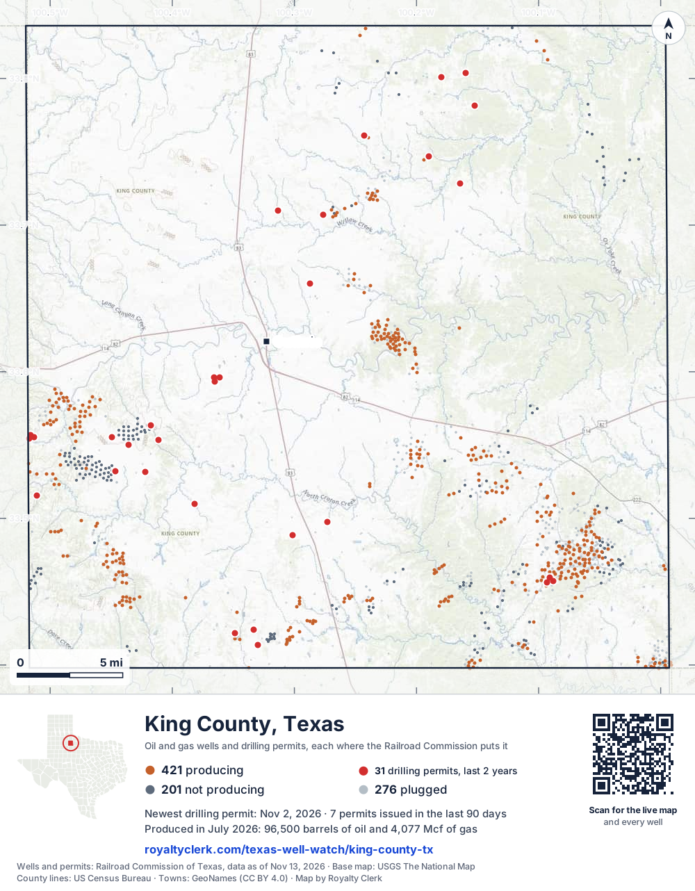
- Drilling locations31Permits issued in the last two years
- Producing wells421On a lease reporting production now
- Not producing200Shut in, inactive or no lease on record
- Plugged277The state's wellbore record says plugged
Sources: Railroad Commission of Texas well layers and permit files, US Census Bureau county outline, town points from GeoNames (CC BY 4.0), base map from USGS The National Map. A dot is a surface location; a horizontal well runs a mile or more from it.
898 wells with a location on the state's map and 31 drilling locations permitted in the last 24 months, each where the Railroad Commission puts it.
A permit is not a well.
Wells near each town in King County
Wells within 10 miles of each town, on either side of the county line.
Use this map on your site
You may show this map on any site, unchanged. Keep the credit line and its link to Royalty Clerk under the map. The picture updates by itself as the state records new wells and permits.
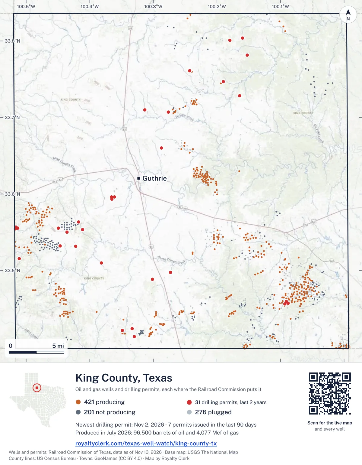
<a href="https://royaltyclerk.com/texas-well-watch/king-county-tx"><img src="https://royaltyclerk.com/maps/county-wells/king-county-tx.svg" alt="Map of King County, Texas, with 898 oil and gas wells and 31 recent drilling locations as dots." width="1000" height="1282" loading="lazy" style="max-width:100%;height:auto;border:0"></a>
<p style="margin:4px 0 0;font-size:14px">Map: <a href="https://royaltyclerk.com/texas-well-watch/king-county-tx">King County, Texas oil and gas wells</a> by Royalty Clerk, from Railroad Commission of Texas records</p>
The last twelve months
Month by month in King County
| Month | Permits | Completions | First production |
|---|---|---|---|
| Nov 2026 | 1 | 0 | 0 |
| Oct 2026 | 1 | 0 | 0 |
| Sep 2026 | 4 | 0 | 0 |
| Aug 2026 | 1 | 0 | 0 |
| Jul 2026 | 0 | 2 | 0 |
| Jun 2026 | 3 | 0 | 0 |
| May 2026 | 1 | 1 | 0 |
| Apr 2026 | 1 | 3 | 1 |
| Feb 2026 | 1 | 0 | 0 |
| Jan 2026 | 0 | 1 | 0 |
| Dec 2025 | 0 | 1 | 0 |
Counted from November 19, 2025 to November 2, 2026, so the first and last months are partial. Source: Railroad Commission of Texas data sets.
Free, no sign-in
The newest drilling permits in King County
| Issued | Lease and well | Operator | Drilling began | Depth, ft | API number | Coordinates | Permit |
|---|---|---|---|---|---|---|---|
| 2026-11-02 | SIMPSON 7Anew drill · verticalSalida Exploration, LLCAPI 42-269-33077 · permit 091984433.42182, -100.348614,000 ft | Salida Exploration, LLC | |||||
| 2026-10-28 | PITCHFORK TTTT 4new drill · verticalMedders Oil Company, Inc.API 42-269-33076 · permit 091971033.55425, -100.517054,500 ft | Medders Oil Company, Inc. | |||||
| 2026-09-27 | PEARLS 'A' 2new drill · verticalHalliburton Operating CompanyAPI 42-269-33073 · permit 091789133.59314, -100.365384,000 ft | Halliburton Operating Company | |||||
| 2026-09-16 | BURNETT RANCH CO2 FLOOD 'PA1' 1BInew drill · verticalHigh River Res Operating, LLCAPI 42-269-33015 · permit 091799633.45644, -100.093236,100 ft | High River Res Operating, LLC | |||||
| 2026-09-09 | BURNETT RANCH CO2 FLOOD 'PA1' 1WInew drill · verticalHigh River Res Operating, LLCAPI 42-269-33017 · permit 091799933.45716, -100.088256,100 ft | High River Res Operating, LLC | |||||
| 2026-09-01 | LEGACY SOUTH 1new drill · verticalHalliburton Operating CompanyAPI 42-269-33074 · permit 091818133.53184, -100.421964,200 ft | Halliburton Operating Company | |||||
| 2026-08-24 | BURNETT RANCH CO2 FLOOD 'PA1' 1MInew drill · verticalHigh River Res Operating, LLCAPI 42-269-33016 · permit 091799733.45949, -100.090806,100 ft | High River Res Operating, LLC | |||||
| 2026-06-22 | BOC 'A' 1new drill · verticalGeosurveys, Inc.API 42-269-33072 · permit 091633833.66033, -100.28699drilling began 2026-07-17 · 6,200 ft | Geosurveys, Inc. | |||||
| 2026-06-10 | CROTON CREEK 1new drill · verticalHalliburton Operating CompanyAPI 42-269-33071 · permit 091629533.50994, -100.38157drilling began 2026-06-22 · 4,000 ft | Halliburton Operating Company | |||||
| 2026-06-08 | PEARLS 2new drill · verticalHalliburton Operating CompanyAPI 42-269-33070 · permit 091573533.59597, -100.36148drilling began 2026-06-10 · 4,000 ft | Halliburton Operating Company | |||||
| 2026-05-06 | FOUR SIXES QF 1new drill · verticalNBX Energy, LLCAPI 42-269-33069 · permit 091519533.70990, -100.31336drilling began 2026-06-01 · 5,500 ft | NBX Energy, LLC | |||||
| 2026-04-29 | FOUR SIXES ST 1new drill · verticalNBX Energy, LLCAPI 42-269-33068 · permit 091518633.70705, -100.27651drilling began 2026-05-16 · 5,500 ft | NBX Energy, LLC | |||||
| 2026-02-18 | PEARLS 1new drill · verticalHalliburton Operating CompanyAPI 42-269-33067 · permit 091350933.59593, -100.36598drilling began 2026-02-24 · 4,000 ft | Halliburton Operating Company | |||||
| 2025-11-10 | PITCHFORK SSSS 2new drill · verticalMedders Oil Company, Inc.API 42-269-33066 · permit 091164233.51561, -100.51074drilling began 2026-02-13 · 4,500 ft | Medders Oil Company, Inc. | |||||
| 2025-11-10 | PITCHFORK TTTT 2new drill · verticalMedders Oil Company, Inc.API 42-269-33065 · permit 091164133.55522, -100.51319drilling began 2026-01-16 · 4,500 ft | Medders Oil Company, Inc. | |||||
| 2025-09-18 | SIMPSON 6Anew drill · verticalSalida Exploration, LLCAPI 42-269-33064 · permit 091052333.41390, -100.33019drilling began 2025-10-29 · 4,000 ft | Salida Exploration, LLC | |||||
| 2025-08-06 | SIXES PICK 1new drill · verticalGunn Oil CompanyAPI 42-269-33063 · permit 090972933.48858, -100.30149drilling began 2025-09-30 · 9,000 ft | Gunn Oil Company | |||||
| 2025-08-06 | OLD EIGHT 1new drill · verticalGunn Oil CompanyAPI 42-269-33062 · permit 090972733.76123, -100.24266drilling began 2025-09-18 · 9,000 ft | Gunn Oil Company | |||||
| 2025-07-30 | SLOAN 1new drill · verticalGunn Oil CompanyAPI 42-269-33061 · permit 090956033.78167, -100.152509,000 ft | Gunn Oil Company | |||||
| 2025-07-28 | SALLIE LEE 4new drill · verticalGunn Oil CompanyAPI 42-269-33060 · permit 090948933.80393, -100.159529,000 ft | Gunn Oil Company | |||||
| 2025-07-23 | SALLIE LEE 3new drill · verticalGunn Oil CompanyAPI 42-269-33059 · permit 090937733.80082, -100.17986drilling began 2025-08-25 · 9,000 ft | Gunn Oil Company | |||||
| 2025-07-22 | STOCKGROWERS 1new drill · verticalGunn Oil CompanyAPI 42-269-33058 · permit 090936733.72861, -100.16417drilling began 2025-09-11 · 9,000 ft | Gunn Oil Company | |||||
| 2025-07-22 | MIMSY 2new drill · verticalGunn Oil CompanyAPI 42-269-33057 · permit 090936633.74684, -100.18998drilling began 2025-09-02 · 9,000 ft | Gunn Oil Company | |||||
| 2025-06-24 | SHERIDAN RANCH 1new drill · verticalGunn Oil CompanyAPI 42-269-33056 · permit 090877733.49735, -100.27284drilling began 2025-08-14 · 9,000 ft | Gunn Oil Company | |||||
| 2025-06-11 | CROWNFIELD 3new drill · verticalGunn Oil CompanyAPI 42-269-33055 · permit 090848533.55370, -100.41115drilling began 2025-08-06 · 9,000 ft | Gunn Oil Company | |||||
| 2025-06-11 | CROWNFIELD 2new drill · verticalGunn Oil CompanyAPI 42-269-33054 · permit 090848433.55031, -100.43586drilling began 2025-07-29 · 9,000 ft | Gunn Oil Company | |||||
| 2025-06-04 | CROWNFIELD 1new drill · verticalGunn Oil CompanyAPI 42-269-33053 · permit 090841533.53201, -100.44649drilling began 2025-07-21 · 9,000 ft | Gunn Oil Company | |||||
| 2025-05-15 | CRUM 1new drill · verticalSojourner Drilling CorporationAPI 42-269-33052 · permit 090795033.42418, -100.33309drilling began 2025-07-08 · 4,000 ft | Sojourner Drilling Corporation | |||||
| 2025-03-12 | PITCHFORK TTTT 1new drill · verticalMedders Oil Company, Inc.API 42-269-33051 · permit 090652633.55657, -100.51579drilling began 2025-04-16 · 4,500 ft | Medders Oil Company, Inc. | |||||
| 2024-12-20 | SOMERVELL 6666 1WSnew drill · verticalBurnett Oil Co., Inc.API 42-269-33049 · permit 090486233.56348, -100.41729drilling began 2025-02-11 · 4,500 ft | Burnett Oil Co., Inc. | |||||
| 2024-12-20 | PITCHFORK 1WSnew drill · verticalBurnett Oil Co., Inc.API 42-269-33050 · permit 090486133.55516, -100.44948drilling began 2025-01-30 · 4,500 ft | Burnett Oil Co., Inc. | |||||
| 2024-11-01 | BACON 'C' 1Cnew drill · verticalSalida Exploration, LLCAPI 42-269-33048 · permit 090367133.45222, -100.29159drilling began 2024-11-12 · 4,000 ft | Salida Exploration, LLC | |||||
| 2024-10-30 | BACON 114 3Bnew drill · verticalSalida Exploration, LLCAPI 42-269-33047 · permit 090366533.43183, -100.30821drilling began 2024-11-20 · 4,000 ft | Salida Exploration, LLC | |||||
| 2024-10-24 | AWM 'E' 1recompletion · verticalBurnett Oil Co., Inc.API 42-269-32346 · permit 090347533.71484, -100.249764,520 ft | Burnett Oil Co., Inc. | |||||
| 2024-09-11 | CORINNE 1new drill · verticalGunn Oil CompanyAPI 42-269-33046 · permit 090260533.83086, -100.38688drilling began 2024-10-01 · 9,000 ft | Gunn Oil Company | |||||
| 2024-08-21 | PITCHFORK YYY 11new drill · verticalMedders Oil Company, Inc.API 42-269-33045 · permit 090214633.53036, -100.50283drilling began 2024-09-16 · 4,500 ft | Medders Oil Company, Inc. | |||||
| 2024-08-15 | HARDWICK 3new drill · verticalS.b. Street Operating, Inc.API 42-269-33044 · permit 090188233.40245, -100.01861drilling began 2024-09-16 · 6,000 ft | S.b. Street Operating, Inc. | |||||
| 2024-08-06 | BUZZARD PEAK 2new drill · verticalSojourner Drilling CorporationAPI 42-269-33043 · permit 090180933.50991, -99.99348drilling began 2024-08-16 · 3,500 ft | Sojourner Drilling Corporation | |||||
| 2024-07-08 | QQQ HIGH RIVER 4recompletion · verticalSojourner Drilling CorporationAPI 42-269-31940 · permit 090095933.46807, -100.04251drilling began 2024-07-01 · 6,000 ft | Sojourner Drilling Corporation | |||||
| 2024-06-11 | TP 21.18 1new drill · verticalEnergy Transfer CompanyAPI 42-269-33042 · permit 090025133.80890, -100.06375410 ft | Energy Transfer Company | |||||
| 2024-06-11 | TP 21.10 1new drill · verticalEnergy Transfer CompanyAPI 42-269-33041 · permit 090024833.77639, -100.05163410 ft | Energy Transfer Company | |||||
| 2024-06-11 | TP 21.15 1new drill · verticalEnergy Transfer CompanyAPI 42-269-33040 · permit 090024733.79575, -100.05858410 ft | Energy Transfer Company | |||||
| 2024-06-11 | TP 20.85 1new drill · verticalEnergy Transfer CompanyAPI 42-269-33039 · permit 090023333.75789, -100.04558385 ft | Energy Transfer Company | |||||
| 2024-04-19 | HARDWICK 2new drill · verticalS.b. Street Operating, Inc.API 42-269-33038 · permit 089892733.40696, -100.01613drilling began 2024-05-18 · 6,000 ft | S.b. Street Operating, Inc. | |||||
| 2024-04-01 | SPRINGER-WILSON 189 2new drill · verticalBuck Wheat Resources, L.P.API 42-269-33037 · permit 089845833.47062, -100.43680drilling began 2024-04-17 · 4,000 ft | Buck Wheat Resources, L.P. | |||||
| 2023-11-15 | DR. SCOTT 1new drill · verticalGunn Oil CompanyAPI 42-269-33036 · permit 089531133.77343, -100.20761drilling began 2024-02-26 · 9,000 ft | Gunn Oil Company | |||||
| 2023-11-15 | MIMSY 1new drill · verticalGunn Oil CompanyAPI 42-269-33035 · permit 089530933.74454, -100.19403drilling began 2024-03-12 · 9,000 ft | Gunn Oil Company | |||||
| 2023-11-09 | BURNETT/GUNN AWM 'D' 2recompletion · verticalBurnett Oil Co., Inc.API 42-269-32336 · permit 089480933.70549, -100.26857drilling began 2023-12-04 · 4,400 ft | Burnett Oil Co., Inc. | |||||
| 2023-11-08 | SALLIE LEE 2new drill · verticalGunn Oil CompanyAPI 42-269-33034 · permit 089514633.80166, -100.17876drilling began 2024-04-01 · 9,000 ft | Gunn Oil Company | |||||
| 2023-11-08 | SALLIE LEE 1new drill · verticalGunn Oil CompanyAPI 42-269-33033 · permit 089514533.79269, -100.17385drilling began 2024-04-18 · 9,000 ft | Gunn Oil Company |
These are the newest 50 of 53 permits on file for King County. The rest follow, 50 to a page.
A permit is permission to drill, not a well. Source: Railroad Commission of Texas drilling permit files.
Year by year
Drilling permits issued in King County, by year
| Year | Permits issued |
|---|---|
| 2026 so far | 13 |
| 2025 | 16 |
| 2024 | 16 |
| 2023 | 8 |
Counted from the permit files we hold, which start in 2023; that first year may be partial. Source: Railroad Commission of Texas drilling permit files.
The latest
The most recent records
| Date | What, who and where |
|---|---|
| 2026-11-02 | Permit issued: Salida Exploration, LLCSIMPSON · A-142 · permit 0919844 |
| 2026-10-28 | Permit issued: Medders Oil Company, Inc.PITCHFORK TTTT · A-284 · permit 0919710 |
| 2026-09-27 | Permit issued: Halliburton Operating CompanyPEARLS 'A' · A-1113 · permit 0917891 |
| 2026-09-16 | Permit issued: High River Res Operating, LLCBURNETT RANCH CO2 FLOOD 'PA1' · A-1186 · permit 0917996 |
| 2026-09-09 | Permit issued: High River Res Operating, LLCBURNETT RANCH CO2 FLOOD 'PA1' · A-1186 · permit 0917999 |
| 2026-09-01 | Permit issued: Halliburton Operating CompanyLEGACY SOUTH · A-286 · permit 0918181 |
| 2026-08-24 | Permit issued: High River Res Operating, LLCBURNETT RANCH CO2 FLOOD 'PA1' · A-1186 · permit 0917997 |
| 2026-07-16 | Completed: High River Res Operating, LLCBURNETT RANCH CO2 FLOOD "PA1" · A-641 |
| 2026-07-14 | Completed: Burnett Oil Co., Inc.AWM "E" · A-578 |
| 2026-06-22 | Permit issued: Geosurveys, Inc.BOC 'A' · A-241 · permit 0916338 |
| 2026-06-10 | Permit issued: Halliburton Operating CompanyCROTON CREEK · A-1031 · permit 0916295 |
| 2026-06-08 | Permit issued: Halliburton Operating CompanyPEARLS · A-1113 · permit 0915735 |
| 2026-05-18 | Completed: High River Res Operating, LLCBURNETT, S. B. ESTATE "RRR" · A-49 |
| 2026-05-06 | Permit issued: NBX Energy, LLCFOUR SIXES QF · A-815 · permit 0915195 |
| 2026-04-30 | Completed: Burnett Oil Co., Inc.BURNETT/GUNN AWM "D" · A-550 |
Coming up
First checks coming due in King County
- BURNETT RANCH CO2 FLOOD "PA1", High River Res Operating, LLCby November 28, 2026
Follow it
Watch King County, or one abstract
What do you want to follow?
Where the land is. Your deed or lease names it.
For example A-1119, or Bush, or T&P 38. Your deed or the tax bill has it.
Other counties
Drilling activity in other counties
Related
Related
- ToolTexas well watchPermit, completion, first production and when the first check is due.
- ToolIs this buyout offer fair?The offer as months of your income, what the acres mean, and the questions to ask.
- ToolIs this lease offer good?Bonus and royalty against the county, and a scan of the lease's clauses.
- Texas dataTexas operator changesWho took over whose leases in the last 24 months.
- ToolLate payment interestDeadlines and the interest a late payment earns.
- Texas dataTexas oil and gas atlas254 counties, every lease, operator and field.
FAQ
Questions people ask
How many wells were permitted in King County in the last year?
The Railroad Commission issued 13 drilling permits in King County in the twelve months to November 2, 2026, and recorded 8 completions and 1 first-production report. A permit is permission to drill, not a well.
How do I get an alert when a permit is issued near my land in King County?
Choose your abstract on this page, or the whole county, and sign in. You get one email a week, only when something new is recorded after you sign up. The alert says whether an event is on an interest in your Mineral File, on a place you follow, or only nearby.
When is my first royalty check due after a new well?
Natural Resources Code section 91.402(a) says on or before 120 days after the end of the month of first sale of production from the well. The state's first-production month is the closest public marker, so the date on this page is the earliest, not a certainty.
Got a new well on your land?
The first check is due within 120 days after the end of the month of first sale.
Sources
Primary sources, opened on 29 September 2026. Statute text is the current version on statutes.capitol.texas.gov.