
Lavaca County, Texas
Lavaca County drilling permits: what the state recorded
- 46drilling permits
- 41completions
- 18first-production reports
- in the last twelve months
Wells by coordinates
Oil wells and drilling locations in Lavaca County
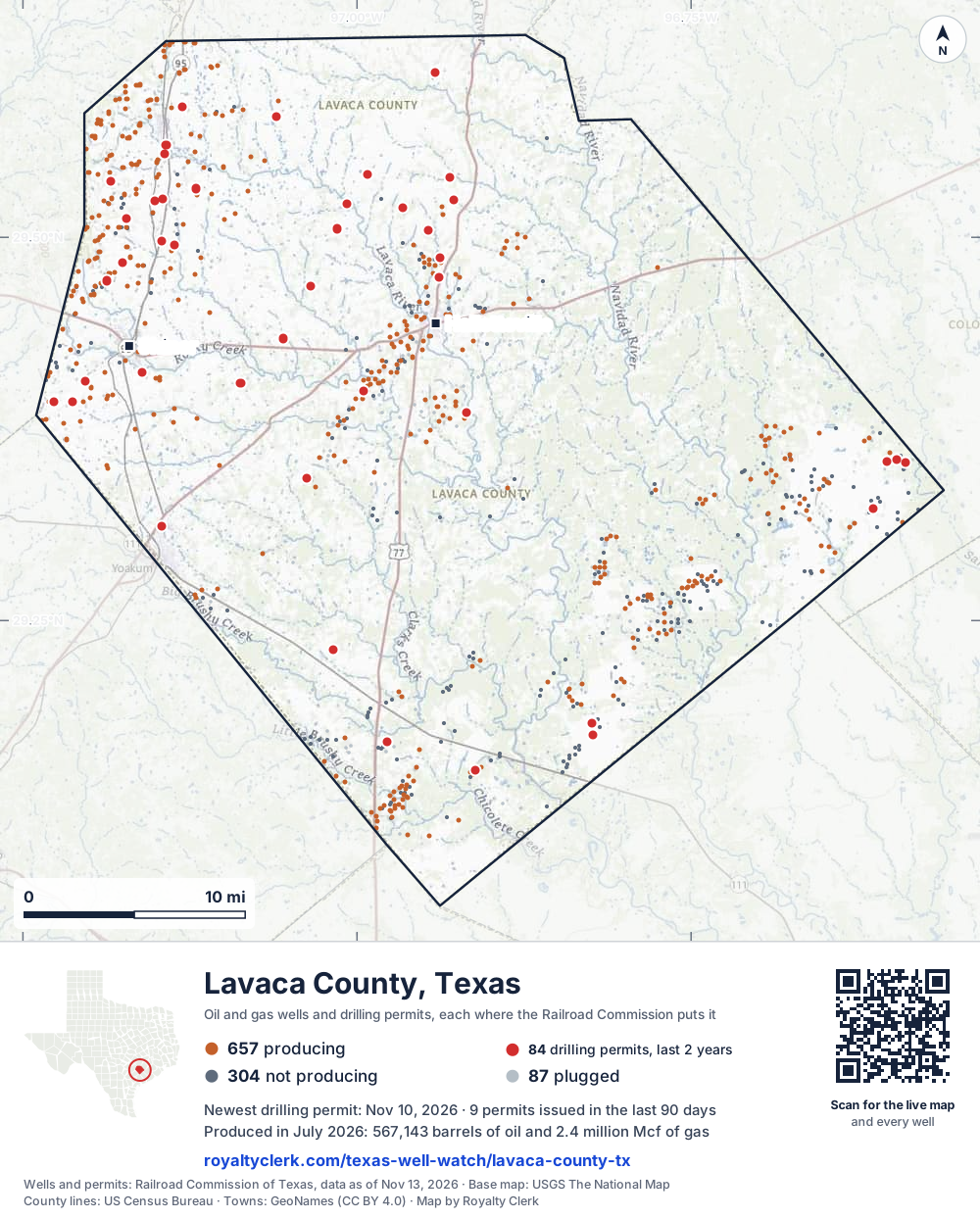
- Drilling locations84Permits issued in the last two years
- Producing wells657On a lease reporting production now
- Not producing304Shut in, inactive or no lease on record
- Plugged87The state's wellbore record says plugged
Sources: Railroad Commission of Texas well layers and permit files, US Census Bureau county outline, town points from GeoNames (CC BY 4.0), base map from USGS The National Map. A dot is a surface location; a horizontal well runs a mile or more from it.
1,048 wells with a location on the state's map and 84 drilling locations permitted in the last 24 months, each where the Railroad Commission puts it.
A permit is not a well.
Lavaca County is one of the 27 counties of the Eagle Ford Shale
Wells near each town in Lavaca County
Wells within 10 miles of each town, on either side of the county line.
Use this map on your site
You may show this map on any site, unchanged. Keep the credit line and its link to Royalty Clerk under the map. The picture updates by itself as the state records new wells and permits.
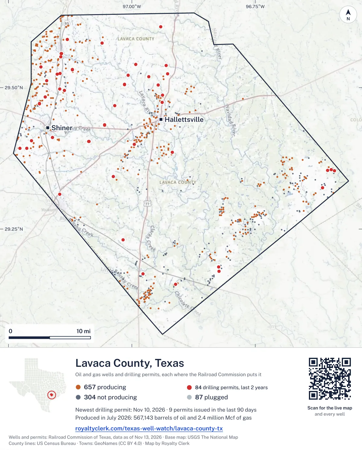
<a href="https://royaltyclerk.com/texas-well-watch/lavaca-county-tx"><img src="https://royaltyclerk.com/maps/county-wells/lavaca-county-tx.svg" alt="Map of Lavaca County, Texas, with 1,048 oil and gas wells and 84 recent drilling locations as dots." width="1000" height="1244" loading="lazy" style="max-width:100%;height:auto;border:0"></a>
<p style="margin:4px 0 0;font-size:14px">Map: <a href="https://royaltyclerk.com/texas-well-watch/lavaca-county-tx">Lavaca County, Texas oil and gas wells</a> by Royalty Clerk, from Railroad Commission of Texas records</p>
The last twelve months
Month by month in Lavaca County
| Month | Permits | Completions | First production |
|---|---|---|---|
| Nov 2026 | 2 | 0 | 0 |
| Oct 2026 | 7 | 1 | 0 |
| Sep 2026 | 0 | 3 | 0 |
| Aug 2026 | 0 | 7 | 0 |
| Jul 2026 | 4 | 6 | 2 |
| Jun 2026 | 4 | 3 | 0 |
| May 2026 | 3 | 1 | 0 |
| Apr 2026 | 1 | 1 | 3 |
| Mar 2026 | 11 | 6 | 5 |
| Feb 2026 | 2 | 3 | 1 |
| Jan 2026 | 3 | 3 | 3 |
| Dec 2025 | 7 | 6 | 4 |
| Nov 2025 | 2 | 1 | 0 |
Counted from November 18, 2025 to November 10, 2026, so the first and last months are partial. Source: Railroad Commission of Texas data sets.
Free, no sign-in
The newest drilling permits in Lavaca County
| Issued | Lease and well | Operator | Drilling began | Depth, ft | API number | Coordinates | Permit |
|---|---|---|---|---|---|---|---|
| 2026-11-10 | MCCREARY SA B 2UHnew drill · horizontalFW Eagle Ford I, LLCAPI 42-285-34386 · permit 091989929.51219, -97.1725514,500 ft | FW Eagle Ford I, LLC | |||||
| 2026-11-10 | MCCREARY SA A 1UHnew drill · horizontalFW Eagle Ford I, LLCAPI 42-285-34385 · permit 091989529.51219, -97.1726014,500 ft | FW Eagle Ford I, LLC | |||||
| 2026-10-27 | BLONDE SA B 2Hnew drill · horizontalFW Eagle Ford I, LLCAPI 42-285-34384 · permit 091950529.47167, -97.1869614,500 ft | FW Eagle Ford I, LLC | |||||
| 2026-10-27 | BLONDE SA A 1Hnew drill · horizontalFW Eagle Ford I, LLCAPI 42-285-34383 · permit 091950429.47171, -97.1869614,500 ft | FW Eagle Ford I, LLC | |||||
| 2026-10-20 | L. KASKIE GAS UNIT 1recompletion · verticalHilcorp Energy CompanyAPI 42-285-32808 · permit 091917629.32293, -96.6134414,350 ft | Hilcorp Energy Company | |||||
| 2026-10-20 | RHINO HUNTER SA B 2Hnew drill · horizontalFW Eagle Ford I, LLCAPI 42-285-34382 · permit 091932029.53632, -97.1843414,500 ft | FW Eagle Ford I, LLC | |||||
| 2026-10-20 | RHINO HUNTER SA A 1Hnew drill · horizontalFW Eagle Ford I, LLCAPI 42-285-34381 · permit 091931629.53636, -97.1843414,500 ft | FW Eagle Ford I, LLC | |||||
| 2026-10-13 | KALLUS 2STre-entry · verticalTrio Consulting & Management,llcAPI 42-285-34358 · permit 091917729.38597, -96.9179110,700 ft | Trio Consulting & Management,llc | |||||
| 2026-10-09 | LANIK 3 3Hnew drill · horizontalCapital Star Oil & Gas, Inc.API 42-285-34380 · permit 091912429.39956, -96.9949214,000 ft | Capital Star Oil & Gas, Inc. | |||||
| 2026-07-22 | KORRIBAN B 2Hnew drill · horizontalFW Eagle Ford I, LLCAPI 42-285-34379 · permit 091721529.49786, -97.1459914,500 ft | FW Eagle Ford I, LLC | |||||
| 2026-07-17 | KORRIBAN C 201Hnew drill · horizontalFW Eagle Ford I, LLCAPI 42-285-34378 · permit 091710029.49786, -97.1460814,500 ft | FW Eagle Ford I, LLC | |||||
| 2026-07-17 | KORRIBAN A 1Hnew drill · horizontalFW Eagle Ford I, LLCAPI 42-285-34377 · permit 091709129.49786, -97.1460414,500 ft | FW Eagle Ford I, LLC | |||||
| 2026-07-14 | WASKA 1new drill · verticalRoyal Production Company, Inc.API 42-285-34376 · permit 091710429.34319, -97.0374310,400 ft | Royal Production Company, Inc. | |||||
| 2026-06-16 | MANDALORE C 3Hnew drill · horizontalFW Eagle Ford I, LLCAPI 42-285-34375 · permit 091643329.39255, -97.2129614,500 ft | FW Eagle Ford I, LLC | |||||
| 2026-06-16 | MANDALORE B 201Hnew drill · horizontalFW Eagle Ford I, LLCAPI 42-285-34374 · permit 091642629.39283, -97.2132214,500 ft | FW Eagle Ford I, LLC | |||||
| 2026-06-16 | MANDALORE A 1Hnew drill · horizontalFW Eagle Ford I, LLCAPI 42-285-34373 · permit 091642429.39263, -97.2129514,500 ft | FW Eagle Ford I, LLC | |||||
| 2026-06-11 | NABOO B MIPA UNIT 2Hnew drill · horizontalFW Eagle Ford I, LLCAPI 42-285-34372 · permit 091574029.56008, -97.14285drilling began 2026-06-17 · 11,478 ft | FW Eagle Ford I, LLC | |||||
| 2026-05-15 | BORCHERS 2recompletion · verticalHydrocarbon Operating, Inc.API 42-285-33640 · permit 091558129.17527, -96.82335drilling began 2012-06-17 · 6,300 ft | Hydrocarbon Operating, Inc. | |||||
| 2026-05-14 | BORCHERS 1recompletion · verticalHydrocarbon Operating, Inc.API 42-285-33676 · permit 091548029.18308, -96.82436drilling began 2012-11-30 · 6,160 ft | Hydrocarbon Operating, Inc. | |||||
| 2026-05-11 | DICKSON, R. FOUNDATION 2recompletion · verticalHilcorp Energy CompanyAPI 42-285-33221 · permit 091544029.35281, -96.5893217,220 ft | Hilcorp Energy Company | |||||
| 2026-04-14 | DICKSON, R. FOUNDATION 1recompletion · verticalHilcorp Energy CompanyAPI 42-285-33044 · permit 091477629.35481, -96.5960715,662 ft | Hilcorp Energy Company | |||||
| 2026-03-24 | MACDONALD UNIT 1Hnew drill · horizontalEOG Resources, Inc.API 42-285-34370 · permit 091421529.40480, -97.0873714,000 ft | EOG Resources, Inc. | |||||
| 2026-03-24 | WORTHINGTON UNIT 1Hnew drill · horizontalEOG Resources, Inc.API 42-285-34369 · permit 091421129.40480, -97.08720drilling began 2026-05-07 · 13,500 ft | EOG Resources, Inc. | |||||
| 2026-03-20 | GIBSON UNIT 1Hnew drill · horizontalEOG Resources, Inc.API 42-285-34368 · permit 091420829.40480, -97.08712drilling began 2026-03-30 · 14,000 ft | EOG Resources, Inc. | |||||
| 2026-03-20 | LEAKEY UNIT 1Hnew drill · horizontalEOG Resources, Inc.API 42-285-34371 · permit 091420629.40480, -97.08729drilling began 2026-03-29 · 13,500 ft | EOG Resources, Inc. | |||||
| 2026-03-18 | GLOVER GU 1new drill · verticalPetrovybe Opco LLCAPI 42-285-34367 · permit 091414529.52454, -96.9274010,000 ft | Petrovybe Opco LLC | |||||
| 2026-03-12 | GRAHMANN GU 1new drill · verticalPetrovybe Opco LLCAPI 42-285-34364 · permit 091386329.53901, -96.9306910,000 ft | Petrovybe Opco LLC | |||||
| 2026-03-10 | RISA C 3Hnew drill · horizontalFW Eagle Ford I, LLCAPI 42-285-34366 · permit 091391429.56008, -97.14280drilling began 2026-06-18 · 14,500 ft | FW Eagle Ford I, LLC | |||||
| 2026-03-10 | RISA A 1Hnew drill · horizontalFW Eagle Ford I, LLCAPI 42-285-34365 · permit 091391329.56008, -97.14290drilling began 2026-06-16 · 14,500 ft | FW Eagle Ford I, LLC | |||||
| 2026-03-09 | CHORIZO 1Hnew drill · horizontalPaleo Oil Company LLCAPI 42-285-34363 · permit 091393229.31151, -97.1458213,950 ft | Paleo Oil Company LLC | |||||
| 2026-03-06 | SVETLIK 1new drill · verticalPetrovybe Opco LLCAPI 42-285-34362 · permit 091386229.51949, -96.9658210,000 ft | Petrovybe Opco LLC | |||||
| 2026-03-06 | ALLEN GAS UNIT 1recompletion · verticalHilcorp Energy CompanyAPI 42-285-32289 · permit 091386129.35351, -96.6032914,643 ft | Hilcorp Energy Company | |||||
| 2026-02-20 | TRILL A 1Hnew drill · horizontalFW Eagle Ford I, LLCAPI 42-285-34361 · permit 091342829.55437, -97.1441714,500 ft | FW Eagle Ford I, LLC | |||||
| 2026-02-12 | TRILL B 2Hnew drill · horizontalFW Eagle Ford I, LLCAPI 42-285-34360 · permit 091342929.55437, -97.14412drilling began 2026-05-17 · 14,500 ft | FW Eagle Ford I, LLC | |||||
| 2026-01-28 | KOENNING GU 1new drill · verticalPetrovybe Opco LLCAPI 42-285-34359 · permit 091309129.52217, -97.00757drilling began 2026-02-11 · 9,500 ft | Petrovybe Opco LLC | |||||
| 2026-01-26 | BORCHERS, VIVIAN ET AL 6recompletion · verticalHydrocarbon Operating, Inc.API 42-285-31972 · permit 091301529.15235, -96.91119drilling began 2025-12-17 · 13,300 ft | Hydrocarbon Operating, Inc. | |||||
| 2026-01-13 | TECHNIK 1recompletion · verticalMB Energy, LLCAPI 42-285-30388 · permit 091258829.48678, -96.93775drilling began 1975-06-05 · 9,000 ft | MB Energy, LLC | |||||
| 2025-12-29 | KALLUS 2new drill · verticalTrio Consulting & Management,llcAPI 42-285-34358 · permit 091243729.38597, -96.91791drilling began 2026-01-03 · 11,500 ft | Trio Consulting & Management,llc | |||||
| 2025-12-29 | RYLOTH C 202Hnew drill · horizontalBaytex Energy USA, Inc.API 42-285-34357 · permit 091233829.39295, -97.22674drilling began 2026-04-14 · 14,500 ft | Baytex Energy USA, Inc. | |||||
| 2025-12-19 | RAWLINS UNIT 1Hnew drill · horizontalEOG Resources, Inc.API 42-285-34356 · permit 091227429.50566, -97.0151814,000 ft | EOG Resources, Inc. | |||||
| 2025-12-18 | KENOBI UNIT 1Hnew drill · horizontalEOG Resources, Inc.API 42-285-34355 · permit 091227329.50559, -97.0151814,000 ft | EOG Resources, Inc. | |||||
| 2025-12-18 | BRUHN UNIT 1Hnew drill · horizontalEOG Resources, Inc.API 42-285-34354 · permit 091227229.50573, -97.0151914,000 ft | EOG Resources, Inc. | |||||
| 2025-12-18 | ALFARO UNIT 1Hnew drill · horizontalEOG Resources, Inc.API 42-285-34353 · permit 091227129.50551, -97.0151714,000 ft | EOG Resources, Inc. | |||||
| 2025-12-05 | BAJOR D 4Hnew drill · horizontalFW Eagle Ford I, LLCAPI 42-285-34352 · permit 091204629.52526, -97.14533drilling began 2025-12-13 · 14,500 ft | FW Eagle Ford I, LLC | |||||
| 2025-11-24 | RYLOTH B 201Hnew drill · horizontalBaytex Energy USA, Inc.API 42-285-34351 · permit 091185529.39296, -97.22670drilling began 2026-04-17 · 14,500 ft | Baytex Energy USA, Inc. | |||||
| 2025-11-24 | RYLOTH A 1Hnew drill · horizontalBaytex Energy USA, Inc.API 42-285-34350 · permit 091185329.39295, -97.2267414,500 ft | Baytex Energy USA, Inc. | |||||
| 2025-11-04 | CHAPMAN UNIT 1Hnew drill · horizontalEOG Resources, Inc.API 42-285-34349 · permit 091155029.46810, -97.0348614,000 ft | EOG Resources, Inc. | |||||
| 2025-11-04 | HOLBROOK UNIT 1Hnew drill · horizontalEOG Resources, Inc.API 42-285-34348 · permit 091154629.46825, -97.03486drilling began 2025-12-20 · 14,000 ft | EOG Resources, Inc. | |||||
| 2025-11-04 | MADDOX UNIT 1Hnew drill · horizontalEOG Resources, Inc.API 42-285-34347 · permit 091154529.46803, -97.03486drilling began 2025-11-21 · 14,000 ft | EOG Resources, Inc. | |||||
| 2025-11-04 | BULLARD UNIT 1Hnew drill · horizontalEOG Resources, Inc.API 42-285-34346 · permit 091154429.46818, -97.03486drilling began 2025-11-20 · 14,000 ft | EOG Resources, Inc. |
These are the newest 50 of 135 permits on file for Lavaca County. The rest follow, 50 to a page.
A permit is permission to drill, not a well. Source: Railroad Commission of Texas drilling permit files.
Year by year
Drilling permits issued in Lavaca County, by year
| Year | Permits issued |
|---|---|
| 2026 so far | 37 |
| 2025 | 44 |
| 2024 | 39 |
| 2023 | 12 |
| 2022 | 1 |
| 2021 | 1 |
| 2012 | 1 |
Counted from the permit files we hold, which start in 2012; that first year may be partial. Source: Railroad Commission of Texas drilling permit files.
The latest
The most recent records
| Date | What, who and where |
|---|---|
| 2026-11-10 | Permit issued: FW Eagle Ford I, LLCMCCREARY SA A · A-354 · permit 0919895 |
| 2026-11-10 | Permit issued: FW Eagle Ford I, LLCMCCREARY SA B · A-354 · permit 0919899 |
| 2026-10-27 | Permit issued: FW Eagle Ford I, LLCBLONDE SA B · A-456 · permit 0919505 |
| 2026-10-27 | Permit issued: FW Eagle Ford I, LLCBLONDE SA A · A-456 · permit 0919504 |
| 2026-10-20 | Permit issued: FW Eagle Ford I, LLCRHINO HUNTER SA B · A-216 · permit 0919320 |
| 2026-10-20 | Permit issued: FW Eagle Ford I, LLCRHINO HUNTER SA A · A-216 · permit 0919316 |
| 2026-10-20 | Permit issued: Hilcorp Energy CompanyL. KASKIE GAS UNIT · A-715 · permit 0919176 |
| 2026-10-16 | Completed: FW Eagle Ford I, LLCELK HUNTER · A-52 |
| 2026-10-13 | Permit issued: Trio Consulting & Management,llcKALLUS · A-1 · permit 0919177 |
| 2026-10-09 | Permit issued: Capital Star Oil & Gas, Inc.LANIK 3 · A-24 · permit 0919124 |
| 2026-09-25 | Completed: FW Eagle Ford I, LLCLEOPARD HUNTER · A-4 |
| 2026-09-23 | Completed: FW Eagle Ford I, LLCLEOPARD HUNTER · A-4 |
| 2026-09-16 | Completed: Hilcorp Energy CompanyALLEN GAS UNIT · A-94 · permit 0913861 |
| 2026-08-20 | Completed: Baytex Energy USA, Inc.ZIRCON B · A-474 |
| 2026-08-17 | Completed: FW Eagle Ford I, LLCCALYPSO A · A-290 |
Coming up
First checks coming due in Lavaca County
- NEUHAUS, F. W., Mountain V Texas, LLCby November 28, 2026
- MOULTON C UNIT, FW Eagle Ford I, LLCby November 28, 2026
- Ryloth B, FW Eagle Ford I, LLCby November 28, 2026
- Ryloth C, FW Eagle Ford I, LLCby November 28, 2026
- DICKSON, R. FOUNDATION, Hilcorp Energy Companyby November 28, 2026
- LEOPARD HUNTER, FW Eagle Ford I, LLCby December 29, 2026
- ORYX HUNTER, FW Eagle Ford I, LLCby December 29, 2026
- STAG HUNTER, FW Eagle Ford I, LLCby December 29, 2026
- LEOPARD HUNTER, FW Eagle Ford I, LLCby January 28, 2027
- ALLEN GAS UNIT, Hilcorp Energy Companyby January 28, 2027
Follow it
Watch Lavaca County, or one abstract
What do you want to follow?
Where the land is. Your deed or lease names it.
For example A-1119, or Bush, or T&P 38. Your deed or the tax bill has it.
Other counties
Drilling activity in other counties
Related
Related
- ToolTexas well watchPermit, completion, first production and when the first check is due.
- ToolIs this buyout offer fair?The offer as months of your income, what the acres mean, and the questions to ask.
- ToolIs this lease offer good?Bonus and royalty against the county, and a scan of the lease's clauses.
- Texas dataTexas operator changesWho took over whose leases in the last 24 months.
- ToolLate payment interestDeadlines and the interest a late payment earns.
- Texas dataTexas oil and gas atlas254 counties, every lease, operator and field.
FAQ
Questions people ask
How many wells were permitted in Lavaca County in the last year?
The Railroad Commission issued 46 drilling permits in Lavaca County in the twelve months to November 10, 2026, and recorded 41 completions and 18 first-production reports. A permit is permission to drill, not a well.
How do I get an alert when a permit is issued near my land in Lavaca County?
Choose your abstract on this page, or the whole county, and sign in. You get one email a week, only when something new is recorded after you sign up. The alert says whether an event is on an interest in your Mineral File, on a place you follow, or only nearby.
When is my first royalty check due after a new well?
Natural Resources Code section 91.402(a) says on or before 120 days after the end of the month of first sale of production from the well. The state's first-production month is the closest public marker, so the date on this page is the earliest, not a certainty.
Got a new well on your land?
The first check is due within 120 days after the end of the month of first sale.
Sources
Primary sources, opened on 29 September 2026. Statute text is the current version on statutes.capitol.texas.gov.