
Leon County, Texas
Leon County drilling permits: what the state recorded
- 30drilling permits
- 36completions
- 18first-production reports
- in the last twelve months
Wells by coordinates
Oil wells and drilling locations in Leon County
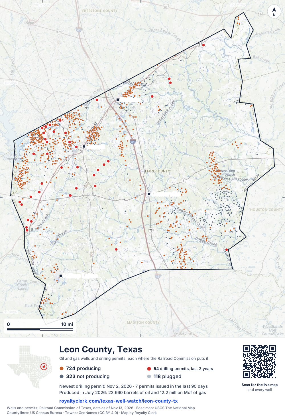
- Drilling locations54Permits issued in the last two years
- Producing wells724On a lease reporting production now
- Not producing323Shut in, inactive or no lease on record
- Plugged118The state's wellbore record says plugged
Sources: Railroad Commission of Texas well layers and permit files, US Census Bureau county outline, town points from GeoNames (CC BY 4.0), base map from USGS The National Map. A dot is a surface location; a horizontal well runs a mile or more from it.
1,165 wells with a location on the state's map and 54 drilling locations permitted in the last 24 months, each where the Railroad Commission puts it.
A permit is not a well.
Leon County is one of the 27 counties of the Eagle Ford Shale
Wells near each town in Leon County
Wells within 10 miles of each town, on either side of the county line.
Use this map on your site
You may show this map on any site, unchanged. Keep the credit line and its link to Royalty Clerk under the map. The picture updates by itself as the state records new wells and permits.
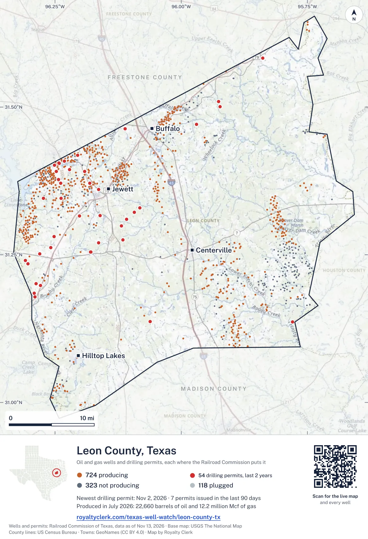
<a href="https://royaltyclerk.com/texas-well-watch/leon-county-tx"><img src="https://royaltyclerk.com/maps/county-wells/leon-county-tx.svg" alt="Map of Leon County, Texas, with 1,165 oil and gas wells and 54 recent drilling locations as dots." width="1000" height="1465" loading="lazy" style="max-width:100%;height:auto;border:0"></a>
<p style="margin:4px 0 0;font-size:14px">Map: <a href="https://royaltyclerk.com/texas-well-watch/leon-county-tx">Leon County, Texas oil and gas wells</a> by Royalty Clerk, from Railroad Commission of Texas records</p>
The last twelve months
Month by month in Leon County
| Month | Permits | Completions | First production |
|---|---|---|---|
| Nov 2026 | 1 | 0 | 0 |
| Oct 2026 | 1 | 0 | 0 |
| Sep 2026 | 4 | 0 | 0 |
| Aug 2026 | 1 | 0 | 1 |
| Jul 2026 | 3 | 4 | 2 |
| Jun 2026 | 3 | 2 | 1 |
| May 2026 | 2 | 6 | 4 |
| Apr 2026 | 6 | 5 | 3 |
| Mar 2026 | 3 | 7 | 6 |
| Feb 2026 | 1 | 3 | 0 |
| Jan 2026 | 0 | 4 | 1 |
| Dec 2025 | 3 | 2 | 0 |
| Nov 2025 | 2 | 3 | 0 |
Counted from November 15, 2025 to November 2, 2026, so the first and last months are partial. Source: Railroad Commission of Texas data sets.
Free, no sign-in
The newest drilling permits in Leon County
| Issued | Lease and well | Operator | Drilling began | Depth, ft | API number | Coordinates | Permit |
|---|---|---|---|---|---|---|---|
| 2026-11-02 | UPR/T-BAR-X KING COBRA 1recompletion · verticalHilcorp Energy CompanyAPI 42-289-31266 · permit 091982531.20089, -96.2874218,038 ft | Hilcorp Energy Company | |||||
| 2026-10-08 | SAMET GAS UNIT 3recompletion · verticalHilcorp Energy CompanyAPI 42-289-31814 · permit 091917231.39107, -96.1909816,031 ft | Hilcorp Energy Company | |||||
| 2026-09-25 | HAYNIE FD 1Hnew drill · horizontalComstock Oil & Gas, LLCAPI 42-289-32236 · permit 091846431.19809, -96.2789730,000 ft | Comstock Oil & Gas, LLC | |||||
| 2026-09-14 | HARRELL 'C' 4recompletion · verticalHilcorp Energy CompanyAPI 42-289-31938 · permit 091850531.34538, -96.2732115,200 ft | Hilcorp Energy Company | |||||
| 2026-09-11 | STROUD GV 1Hnew drill · horizontalComstock Oil & Gas, LLCAPI 42-289-32235 · permit 091841031.58262, -95.8386730,000 ft | Comstock Oil & Gas, LLC | |||||
| 2026-09-11 | FARLEY HG 1Hnew drill · horizontalComstock Oil & Gas, LLCAPI 42-289-32237 · permit 091846531.19809, -96.2789730,000 ft | Comstock Oil & Gas, LLC | |||||
| 2026-08-25 | NEYLAND ML 1Hnew drill · horizontalComstock Oil & Gas, LLCAPI 42-289-32234 · permit 091794131.28064, -96.2519130,000 ft | Comstock Oil & Gas, LLC | |||||
| 2026-07-31 | HOLT MH C 3Hnew drill · horizontalComstock Oil & Gas, LLCAPI 42-289-32232 · permit 091746931.25490, -96.17941drilling began 2026-08-29 · 30,000 ft | Comstock Oil & Gas, LLC | |||||
| 2026-07-31 | HOLT MHP B 2Hnew drill · horizontalComstock Oil & Gas, LLCAPI 42-289-32233 · permit 091746831.25493, -96.1793630,000 ft | Comstock Oil & Gas, LLC | |||||
| 2026-07-16 | TRINITY BLUFF 1new drill · verticalMaximus Operating, Ltd.API 42-289-32231 · permit 091704031.13659, -95.779368,999 ft | Maximus Operating, Ltd. | |||||
| 2026-06-23 | GAIL KING 41recompletion · verticalHilcorp Energy CompanyAPI 42-289-31796 · permit 091664031.37721, -96.2429815,570 ft | Hilcorp Energy Company | |||||
| 2026-06-18 | NEYLAND BG 1Hnew drill · horizontalComstock Oil & Gas, LLCAPI 42-289-32230 · permit 091587231.28058, -96.2519130,000 ft | Comstock Oil & Gas, LLC | |||||
| 2026-06-03 | GAIL KING 15recompletion · verticalHilcorp Energy CompanyAPI 42-289-31495 · permit 091611631.40521, -96.2426314,894 ft | Hilcorp Energy Company | |||||
| 2026-05-18 | FULLEN GAS UNIT 5Hrecompletion · horizontalHilcorp Energy CompanyAPI 42-289-31991 · permit 091568331.41821, -96.2051917,842 ft | Hilcorp Energy Company | |||||
| 2026-05-15 | WELDON COX GAS UNIT 2Hrecompletion · horizontalHilcorp Energy CompanyAPI 42-289-31831 · permit 091551731.39429, -96.2211517,825 ft | Hilcorp Energy Company | |||||
| 2026-04-29 | SWANSON GAS UNIT 1recompletion · verticalHilcorp Energy CompanyAPI 42-289-31914 · permit 091517131.36051, -96.1634517,177 ft | Hilcorp Energy Company | |||||
| 2026-04-20 | JIMMY BEDDINGFIELD GAS UNIT II 1recompletion · verticalHilcorp Energy CompanyAPI 42-289-31525 · permit 091498731.40148, -96.2511415,200 ft | Hilcorp Energy Company | |||||
| 2026-04-08 | KERN NWS 1Hnew drill · horizontalComstock Oil & Gas, LLCAPI 42-289-32229 · permit 091449431.27545, -96.11518drilling began 2026-04-23 · 30,000 ft | Comstock Oil & Gas, LLC | |||||
| 2026-04-08 | KERN PP 1Hnew drill · horizontalComstock Oil & Gas, LLCAPI 42-289-32228 · permit 091449331.27548, -96.11524drilling began 2026-04-22 · 30,000 ft | Comstock Oil & Gas, LLC | |||||
| 2026-04-02 | HOLMES 'S' 1recompletion · verticalHilcorp Energy CompanyAPI 42-289-31111 · permit 091445231.37082, -96.2385810,100 ft | Hilcorp Energy Company | |||||
| 2026-04-02 | GAIL KING 24Hrecompletion · horizontalHilcorp Energy CompanyAPI 42-289-31819 · permit 091445031.39095, -96.2474219,000 ft | Hilcorp Energy Company | |||||
| 2026-03-16 | LEON CO ALLOC 38Hnew drill · horizontalComstock Oil & Gas, LLCAPI 42-289-32227 · permit 091404131.31640, -96.16047drilling began 2026-04-10 · 30,000 ft | Comstock Oil & Gas, LLC | |||||
| 2026-03-09 | DANFORD CS 1Hnew drill · horizontalComstock Oil & Gas, LLCAPI 42-289-32226 · permit 091378331.50069, -95.9228630,000 ft | Comstock Oil & Gas, LLC | |||||
| 2026-03-04 | GAIL KING 23Hrecompletion · horizontalHilcorp Energy CompanyAPI 42-289-31559 · permit 091367731.40464, -96.2415414,493 ft | Hilcorp Energy Company | |||||
| 2026-02-20 | GAIL KING 6recompletion · verticalHilcorp Energy CompanyAPI 42-289-31399 · permit 091345831.40840, -96.2314014,834 ft | Hilcorp Energy Company | |||||
| 2025-12-22 | T.C. SMITH FAMILY TRUST 1new drill · verticalBarbee, R.l. Operating, Inc.API 42-289-32225 · permit 091243231.13704, -96.061387,800 ft | Barbee, R.l. Operating, Inc. | |||||
| 2025-12-17 | WINN CR 1Hnew drill · horizontalComstock Oil & Gas, LLCAPI 42-289-32224 · permit 091221831.24001, -96.30878drilling began 2026-01-19 · 30,000 ft | Comstock Oil & Gas, LLC | |||||
| 2025-12-08 | DUBOIS 1recompletion · verticalTerrain Water Solutions, LLCAPI 42-289-31575 · permit 091203931.34566, -96.23767drilling began 2006-05-26 · 16,000 ft | Terrain Water Solutions, LLC | |||||
| 2025-11-21 | SEABERG ES 1Hnew drill · horizontalComstock Oil & Gas, LLCAPI 42-289-32223 · permit 091185831.29904, -96.11862drilling began 2026-01-20 · 30,000 ft | Comstock Oil & Gas, LLC | |||||
| 2025-11-21 | SEABERG OTA 1Hnew drill · horizontalComstock Oil & Gas, LLCAPI 42-289-32222 · permit 091184831.29898, -96.11861drilling began 2026-01-22 · 30,000 ft | Comstock Oil & Gas, LLC | |||||
| 2025-10-31 | HOLT MHP 1Hnew drill · horizontalComstock Oil & Gas, LLCAPI 42-289-32221 · permit 091142231.25484, -96.17928drilling began 2025-12-05 · 30,000 ft | Comstock Oil & Gas, LLC | |||||
| 2025-10-27 | JBC RANCH 1Hnew drill · horizontalMitsui E&P USA LLCAPI 42-289-32220 · permit 091136631.50915, -95.92579drilling began 2025-11-05 · 30,000 ft | Mitsui E&P USA LLC | |||||
| 2025-09-26 | GLASS KG 1Hnew drill · horizontalComstock Oil & Gas, LLCAPI 42-289-32219 · permit 091066331.18506, -96.29126drilling began 2025-11-05 · 30,000 ft | Comstock Oil & Gas, LLC | |||||
| 2025-09-22 | KIKER BK B 2Hnew drill · horizontalComstock Oil & Gas, LLCAPI 42-289-32218 · permit 091056931.27016, -96.1634330,000 ft | Comstock Oil & Gas, LLC | |||||
| 2025-09-04 | LEON 3HBnew drill · horizontalAethon Energy Operating LLCAPI 42-289-32217 · permit 091018831.23457, -96.3033915,475 ft | Aethon Energy Operating LLC | |||||
| 2025-09-04 | LEON 2HBnew drill · horizontalAethon Energy Operating LLCAPI 42-289-32216 · permit 091018731.23461, -96.3033215,500 ft | Aethon Energy Operating LLC | |||||
| 2025-09-04 | LEON 1HBnew drill · horizontalAdamas Energy LLCAPI 42-289-32215 · permit 091018631.23453, -96.30345drilling began 2026-02-06 · 15,650 ft | Adamas Energy LLC | |||||
| 2025-07-24 | KIKER BK 1Hnew drill · horizontalComstock Oil & Gas, LLCAPI 42-289-32214 · permit 090938131.27012, -96.16347drilling began 2025-08-16 · 30,000 ft | Comstock Oil & Gas, LLC | |||||
| 2025-07-22 | LOTSPEICH BJ 1Hnew drill · horizontalComstock Oil & Gas, LLCAPI 42-289-32213 · permit 090928631.32938, -96.08201drilling began 2025-08-23 · 30,000 ft | Comstock Oil & Gas, LLC | |||||
| 2025-07-17 | JONES LA 1Hnew drill · horizontalComstock Oil & Gas, LLCAPI 42-289-32212 · permit 090928531.32933, -96.08200drilling began 2025-08-24 · 30,000 ft | Comstock Oil & Gas, LLC | |||||
| 2025-06-11 | POLLARD MBK 1Hnew drill · horizontalComstock Oil & Gas, LLCAPI 42-289-32211 · permit 090848931.26193, -96.25873drilling began 2025-06-23 · 30,000 ft | Comstock Oil & Gas, LLC | |||||
| 2025-05-22 | ERICSON KN 1Hnew drill · horizontalComstock Oil & Gas, LLCAPI 42-289-32210 · permit 090811931.37110, -96.18082drilling began 2025-07-03 · 30,000 ft | Comstock Oil & Gas, LLC | |||||
| 2025-05-22 | WILLIAMS JWW 1Hnew drill · horizontalComstock Oil & Gas, LLCAPI 42-289-32209 · permit 090811531.37106, -96.18079drilling began 2025-07-04 · 30,000 ft | Comstock Oil & Gas, LLC | |||||
| 2025-05-16 | POLLARD TFG 1Hnew drill · horizontalComstock Oil & Gas, LLCAPI 42-289-32208 · permit 090796031.26198, -96.25874drilling began 2025-06-21 · 30,000 ft | Comstock Oil & Gas, LLC | |||||
| 2025-05-16 | WHITAKER 1Hnew drill · horizontalMitsui E&P USA LLCAPI 42-289-32207 · permit 090792531.46330, -96.11128drilling began 2025-06-27 · 30,000 ft | Mitsui E&P USA LLC | |||||
| 2025-03-27 | BUMPURS BHGJ 1Hnew drill · horizontalComstock Oil & Gas, LLCAPI 42-289-32206 · permit 090690131.25172, -96.28006drilling began 2025-04-11 · 25,000 ft | Comstock Oil & Gas, LLC | |||||
| 2025-03-27 | BUMPURS NMH 1Hnew drill · horizontalComstock Oil & Gas, LLCAPI 42-289-32205 · permit 090689731.25172, -96.28006drilling began 2025-04-12 · 25,000 ft | Comstock Oil & Gas, LLC | |||||
| 2025-02-21 | O. HENSON 1Hnew drill · horizontalMitsui E&P USA LLCAPI 42-289-32204 · permit 090603931.47078, -95.9695130,000 ft | Mitsui E&P USA LLC | |||||
| 2025-02-12 | BROWN TRUEHEART W 1Hnew drill · horizontalComstock Oil & Gas, LLCAPI 42-289-32202 · permit 090582331.32176, -96.09299drilling began 2025-03-12 · 25,000 ft | Comstock Oil & Gas, LLC | |||||
| 2025-02-12 | BROWN TRUEHEART BB 1Hnew drill · horizontalComstock Oil & Gas, LLCAPI 42-289-32203 · permit 090582031.32171, -96.09298drilling began 2025-03-13 · 25,000 ft | Comstock Oil & Gas, LLC |
These are the newest 50 of 66 permits on file for Leon County. The rest follow, 50 to a page.
A permit is permission to drill, not a well. Source: Railroad Commission of Texas drilling permit files.
Year by year
Drilling permits issued in Leon County, by year
| Year | Permits issued |
|---|---|
| 2026 so far | 25 |
| 2025 | 25 |
| 2024 | 14 |
| 2023 | 2 |
Counted from the permit files we hold, which start in 2023; that first year may be partial. Source: Railroad Commission of Texas drilling permit files.
The latest
The most recent records
| Date | What, who and where |
|---|---|
| 2026-11-02 | Permit issued: Hilcorp Energy CompanyUPR/T-BAR-X KING COBRA · A-832 · permit 0919825 |
| 2026-10-08 | Permit issued: Hilcorp Energy CompanySAMET GAS UNIT · A-296 · permit 0919172 |
| 2026-09-25 | Permit issued: Comstock Oil & Gas, LLCHAYNIE FD · A-284 · permit 0918464 |
| 2026-09-14 | Permit issued: Hilcorp Energy CompanyHARRELL 'C' · A-1215 · permit 0918505 |
| 2026-09-11 | Permit issued: Comstock Oil & Gas, LLCFARLEY HG · A-284 · permit 0918465 |
| 2026-09-11 | Permit issued: Comstock Oil & Gas, LLCSTROUD GV · A-589 · permit 0918410 |
| 2026-08-25 | Permit issued: Comstock Oil & Gas, LLCNEYLAND ML · A-125 · permit 0917941 |
| 2026-08-01 | First production: Mitsui E&P USA LLCJBC Ranch · A-105 · permit 0911366 |
| 2026-07-31 | Permit issued: Comstock Oil & Gas, LLCHOLT MHP B · A-577 · permit 0917468 |
| 2026-07-31 | Permit issued: Comstock Oil & Gas, LLCHOLT MH C · A-577 · permit 0917469 |
| 2026-07-21 | Completed: Comstock Oil & Gas, LLCKIKER BK · A-222 · permit 0909381 |
| 2026-07-16 | Permit issued: Maximus Operating, Ltd.TRINITY BLUFF · A-161 · permit 0917040 |
| 2026-07-05 | Completed: Comstock Oil & Gas, LLCHUTTO RODELL · A-285 · permit 0904209 |
| 2026-07-01 | First production: Comstock Oil & Gas, LLCLotspeich BJ · A-437 · permit 0909286 |
| 2026-07-01 | First production: Comstock Oil & Gas, LLCJones LA · A-437 · permit 0909285 |
Coming up
First checks coming due in Leon County
- Jones LA, Comstock Oil & Gas, LLCby November 28, 2026
- Lotspeich BJ, Comstock Oil & Gas, LLCby November 28, 2026
- JBC Ranch, Mitsui E&P USA LLCby December 29, 2026
Follow it
Watch Leon County, or one abstract
What do you want to follow?
Where the land is. Your deed or lease names it.
For example A-1119, or Bush, or T&P 38. Your deed or the tax bill has it.
Other counties
Drilling activity in other counties
Related
Related
- ToolTexas well watchPermit, completion, first production and when the first check is due.
- ToolIs this buyout offer fair?The offer as months of your income, what the acres mean, and the questions to ask.
- ToolIs this lease offer good?Bonus and royalty against the county, and a scan of the lease's clauses.
- Texas dataTexas operator changesWho took over whose leases in the last 24 months.
- ToolLate payment interestDeadlines and the interest a late payment earns.
- Texas dataTexas oil and gas atlas254 counties, every lease, operator and field.
FAQ
Questions people ask
How many wells were permitted in Leon County in the last year?
The Railroad Commission issued 30 drilling permits in Leon County in the twelve months to November 2, 2026, and recorded 36 completions and 18 first-production reports. A permit is permission to drill, not a well.
How do I get an alert when a permit is issued near my land in Leon County?
Choose your abstract on this page, or the whole county, and sign in. You get one email a week, only when something new is recorded after you sign up. The alert says whether an event is on an interest in your Mineral File, on a place you follow, or only nearby.
When is my first royalty check due after a new well?
Natural Resources Code section 91.402(a) says on or before 120 days after the end of the month of first sale of production from the well. The state's first-production month is the closest public marker, so the date on this page is the earliest, not a certainty.
Got a new well on your land?
The first check is due within 120 days after the end of the month of first sale.
Sources
Primary sources, opened on 29 September 2026. Statute text is the current version on statutes.capitol.texas.gov.