
Lipscomb County, Texas
Lipscomb County drilling permits: what the state recorded
- 4drilling permits
- 5completions
- 6first-production reports
- in the last twelve months
Wells by coordinates
Oil wells and drilling locations in Lipscomb County
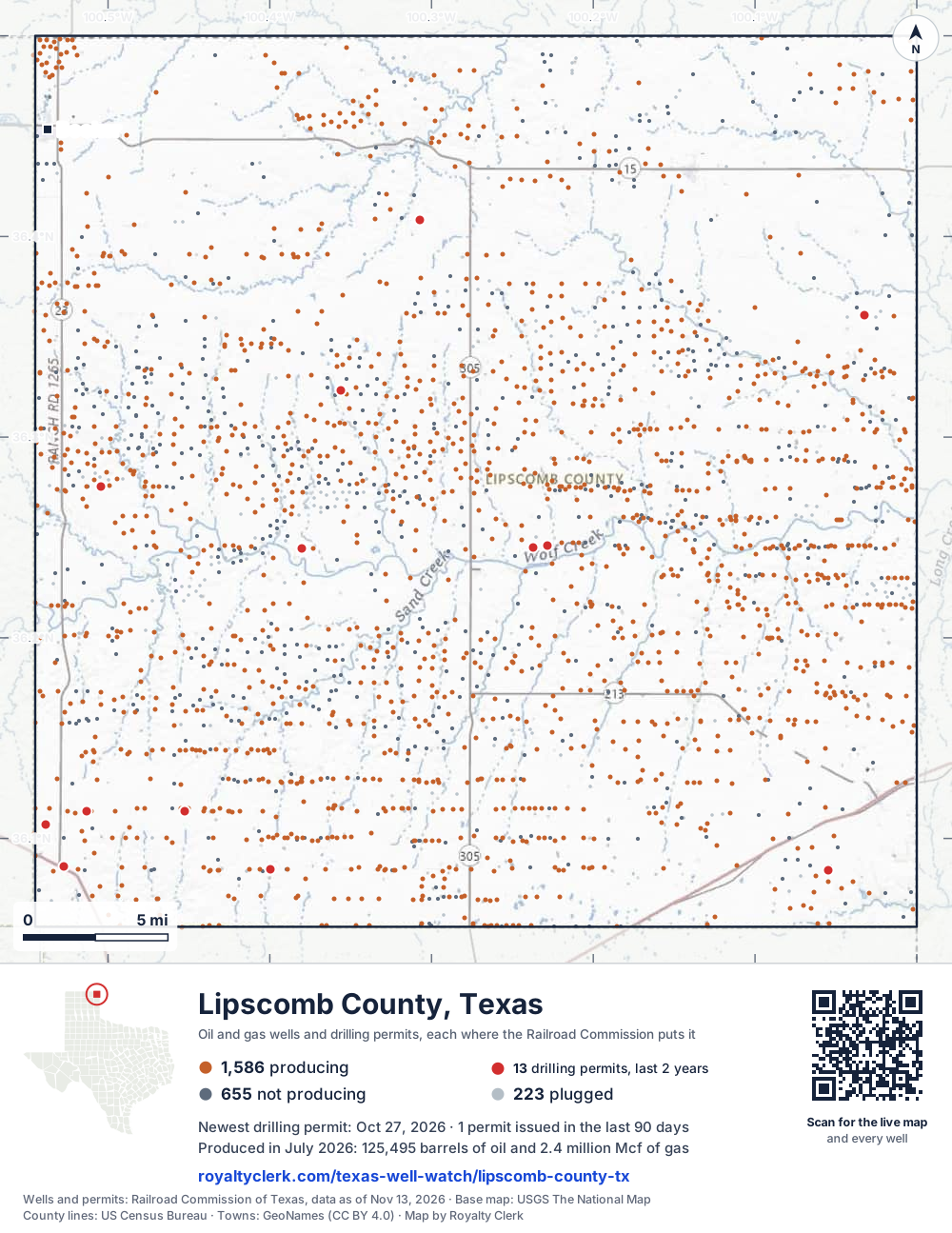
- Drilling locations13Permits issued in the last two years
- Producing wells1,586On a lease reporting production now
- Not producing655Shut in, inactive or no lease on record
- Plugged223The state's wellbore record says plugged
Sources: Railroad Commission of Texas well layers and permit files, US Census Bureau county outline, town points from GeoNames (CC BY 4.0), base map from USGS The National Map. A dot is a surface location; a horizontal well runs a mile or more from it.
2,464 wells with a location on the state's map and 13 drilling locations permitted in the last 24 months, each where the Railroad Commission puts it.
A permit is not a well.
Lipscomb County is one of the 26 counties of the Granite Wash
Wells near each town in Lipscomb County
Wells within 10 miles of each town, on either side of the county line.
Use this map on your site
You may show this map on any site, unchanged. Keep the credit line and its link to Royalty Clerk under the map. The picture updates by itself as the state records new wells and permits.
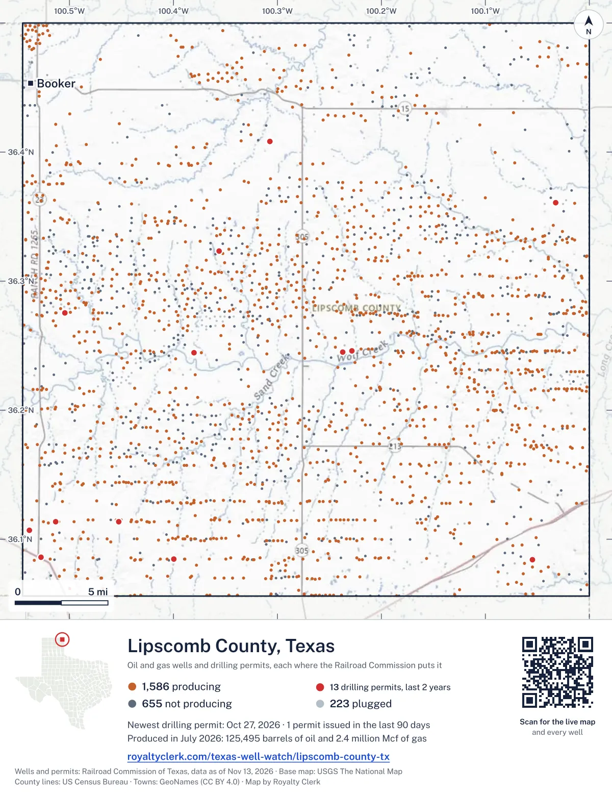
<a href="https://royaltyclerk.com/texas-well-watch/lipscomb-county-tx"><img src="https://royaltyclerk.com/maps/county-wells/lipscomb-county-tx.svg" alt="Map of Lipscomb County, Texas, with 2,464 oil and gas wells and 13 recent drilling locations as dots." width="1000" height="1295" loading="lazy" style="max-width:100%;height:auto;border:0"></a>
<p style="margin:4px 0 0;font-size:14px">Map: <a href="https://royaltyclerk.com/texas-well-watch/lipscomb-county-tx">Lipscomb County, Texas oil and gas wells</a> by Royalty Clerk, from Railroad Commission of Texas records</p>
The last twelve months
Month by month in Lipscomb County
| Month | Permits | Completions | First production |
|---|---|---|---|
| Oct 2026 | 1 | 0 | 0 |
| Jul 2026 | 0 | 0 | 1 |
| May 2026 | 1 | 0 | 0 |
| Apr 2026 | 2 | 1 | 3 |
| Mar 2026 | 0 | 1 | 0 |
| Feb 2026 | 0 | 1 | 1 |
| Jan 2026 | 0 | 1 | 0 |
| Dec 2025 | 0 | 1 | 1 |
Counted from November 15, 2025 to October 27, 2026, so the first and last months are partial. Source: Railroad Commission of Texas data sets.
Free, no sign-in
The newest drilling permits in Lipscomb County
| Issued | Lease and well | Operator | Drilling began | Depth, ft | API number | Coordinates | Permit |
|---|---|---|---|---|---|---|---|
| 2026-10-27 | GUTHRIE 110-67 1Hnew drill · horizontalBe Anadarko II, LLCAPI 42-295-34429 · permit 091958836.08444, -100.399779,000 ft | Be Anadarko II, LLC | |||||
| 2026-05-18 | KELLN 205 C002APnew drill · horizontalMewbourne Oil CompanyAPI 42-295-34428 · permit 091566436.11344, -100.513268,325 ft | Mewbourne Oil Company | |||||
| 2026-04-29 | DOT 1recompletion · verticalUpland Resources LLCAPI 42-295-34375 · permit 091517536.40841, -100.307139,350 ft | Upland Resources LLC | |||||
| 2026-04-29 | ARLENE 2629Hnew drill · horizontalDuncan Oil Properties, Inc.API 42-295-34427 · permit 091516936.24579, -100.22841drilling began 2026-05-25 · 7,813 ft | Duncan Oil Properties, Inc. | |||||
| 2025-10-20 | KELLN 201/152 A C002DMnew drill · horizontalMewbourne Oil CompanyAPI 42-295-34426 · permit 091117136.11359, -100.45261drilling began 2025-12-28 · 8,606 ft | Mewbourne Oil Company | |||||
| 2025-08-15 | STAR 1677Hnew drill · horizontalDuncan Oil Properties, Inc.API 42-295-34425 · permit 090988436.27539, -100.50447drilling began 2025-10-04 · 7,768 ft | Duncan Oil Properties, Inc. | |||||
| 2025-07-14 | ARLENE 1629Hnew drill · horizontalDuncan Oil Properties, Inc.API 42-295-34424 · permit 090863736.24500, -100.23725drilling began 2025-09-14 · 7,817 ft | Duncan Oil Properties, Inc. | |||||
| 2025-05-13 | JOHNSON-KELLN 148/205 A C001MCnew drill · horizontalMewbourne Oil CompanyAPI 42-295-34423 · permit 090787836.08604, -100.52719drilling began 2025-08-11 · 8,305 ft | Mewbourne Oil Company | |||||
| 2025-04-03 | GOSSETT 967 C001CNnew drill · horizontalMewbourne Oil CompanyAPI 42-295-34422 · permit 090710536.36075, -100.03249drilling began 2025-12-11 · 7,756 ft | Mewbourne Oil Company | |||||
| 2025-04-03 | MICHELLE-JONES 91/86 A W001DMnew drill · horizontalMewbourne Oil CompanyAPI 42-295-34421 · permit 090641036.08404, -100.05457drilling began 2025-05-05 · 10,335 ft | Mewbourne Oil Company | |||||
| 2025-02-13 | SCHOENHALS 3861recompletion · verticalCarson Buckles Exploration LLCAPI 42-295-31953 · permit 090502936.32324, -100.3562010,150 ft | Carson Buckles Exploration LLC | |||||
| 2024-11-25 | BOOTH G 3637HXnew drill · horizontalDuncan Oil Properties, Inc.API 42-295-34420 · permit 090373136.24454, -100.38044drilling began 2024-12-29 · 7,833 ft | Duncan Oil Properties, Inc. | |||||
| 2024-11-19 | KELLN-LANDERS 206/235 A C001GAnew drill · horizontalMewbourne Oil CompanyAPI 42-295-34419 · permit 090402836.10711, -100.53876drilling began 2024-12-02 · 8,248 ft | Mewbourne Oil Company | |||||
| 2024-09-23 | DEUCE 3551Hnew drill · horizontalDuncan Oil Properties, Inc.API 42-295-34418 · permit 090277636.21376, -100.41381drilling began 2024-12-10 · 7,783 ft | Duncan Oil Properties, Inc. | |||||
| 2024-09-17 | DEUCE 2551Hnew drill · horizontalDuncan Oil Properties, Inc.API 42-295-34417 · permit 090271336.21372, -100.41383drilling began 2024-11-16 · 8,118 ft | Duncan Oil Properties, Inc. | |||||
| 2024-09-06 | BRAINARD 150/115 A C001COnew drill · horizontalMewbourne Oil CompanyAPI 42-295-34416 · permit 090249836.10045, -100.48902drilling began 2025-03-04 · 8,214 ft | Mewbourne Oil Company | |||||
| 2024-08-13 | KELLN-PARKER 206/147 A C001KNnew drill · horizontalMewbourne Oil CompanyAPI 42-295-34415 · permit 090187236.10711, -100.53876drilling began 2024-12-01 · 8,279 ft | Mewbourne Oil Company | |||||
| 2024-06-18 | FRASS 21 1recompletion · verticalSGP Operating LLCAPI 42-295-34367 · permit 090049836.48150, -100.38172drilling began 2024-05-08 · 8,850 ft | SGP Operating LLC | |||||
| 2024-04-25 | FRITZLEN-WILLIAM 179/174 A W001APnew drill · horizontalMewbourne Oil CompanyAPI 42-295-34414 · permit 089912136.11449, -100.04605drilling began 2024-06-06 · 10,228 ft | Mewbourne Oil Company | |||||
| 2024-03-15 | AKERS 968 C001BOnew drill · horizontalMewbourne Oil CompanyAPI 42-295-34413 · permit 089817436.36050, -100.01418drilling began 2024-05-19 · 7,753 ft | Mewbourne Oil Company | |||||
| 2024-01-24 | HOSTUTLER 451 A C001NCnew drill · horizontalMewbourne Oil CompanyAPI 42-295-34412 · permit 089662636.18610, -100.19711drilling began 2024-03-07 · 8,315 ft | Mewbourne Oil Company | |||||
| 2024-01-10 | BOOTH G 4637HXnew drill · horizontalDuncan Oil Properties, Inc.API 42-295-34411 · permit 089601236.24462, -100.37298drilling began 2024-03-11 · 7,750 ft | Duncan Oil Properties, Inc. | |||||
| 2023-12-07 | BOOTH G 1637Hnew drill · horizontalDuncan Oil Properties, Inc.API 42-295-34410 · permit 089567036.24462, -100.37293drilling began 2024-02-19 · 8,055 ft | Duncan Oil Properties, Inc. | |||||
| 2023-10-03 | DEUCE 1551Hnew drill · horizontalDuncan Oil Properties, Inc.API 42-295-34409 · permit 089424136.21393, -100.40337drilling began 2024-01-18 · 8,140 ft | Duncan Oil Properties, Inc. | |||||
| 2023-08-29 | LOGAN ROY 695-714 1CHnew drill · horizontalRevolution Operating Company,llcAPI 42-295-34406 · permit 089232336.25986, -100.16880drilling began 2023-10-16 · 12,000 ft | Revolution Operating Company,llc | |||||
| 2023-05-22 | THE QUIET MAN 105/107 1Hnew drill · horizontalUpland Exploration, LLCAPI 42-295-34400 · permit 088959136.21477, -100.00285drilling began 2023-05-24 · 9,000 ft | Upland Exploration, LLC |
A permit is permission to drill, not a well. Source: Railroad Commission of Texas drilling permit files.
Year by year
Drilling permits issued in Lipscomb County, by year
| Year | Permits issued |
|---|---|
| 2026 so far | 4 |
| 2025 | 7 |
| 2024 | 11 |
| 2023 | 4 |
Counted from the permit files we hold, which start in 2023; that first year may be partial. Source: Railroad Commission of Texas drilling permit files.
The latest
The most recent records
| Date | What, who and where |
|---|---|
| 2026-10-27 | Permit issued: Be Anadarko II, LLCGUTHRIE 110-67 · A-1140 · permit 0919588 |
| 2026-07-01 | First production: Be Anadarko II, LLCLogan Roy 695-714 |
| 2026-05-18 | Permit issued: Mewbourne Oil CompanyKELLN 205 · A-117 · permit 0915664 |
| 2026-04-29 | Permit issued: Duncan Oil Properties, Inc.ARLENE · A-868 · permit 0915169 |
| 2026-04-29 | Permit issued: Upland Resources LLCDOT · A-1194 · permit 0915175 |
| 2026-04-12 | Completed: Mewbourne Oil CompanyKELLN 201/152 A · A-115 · permit 0911171 |
| 2026-04-01 | First production: Mewbourne Oil CompanyKelln 201/152 A · A-115 · permit 0911171 |
| 2026-04-01 | First production: Presidio Petroleum LLCSchoenhals |
| 2026-04-01 | First production: Presidio Petroleum LLCHelfenbein |
| 2026-03-30 | Completed: Mewbourne Oil CompanyFLOYD |
| 2026-02-12 | Completed: Mewbourne Oil CompanyGOSSETT 967 · A-372 · permit 0907105 |
| 2026-02-01 | First production: Mewbourne Oil CompanyGossett 967 · A-372 · permit 0907105 |
| 2026-01-21 | Completed: Mewbourne Oil CompanyKELLN 201/152 A · A-115 · permit 0911171 |
| 2025-12-22 | Completed: Duncan Oil Properties, Inc.STAR · A-1080 · permit 0909884 |
| 2025-12-01 | First production: Duncan Oil Properties, Inc.Star · A-1080 · permit 0909884 |
Coming up
First checks coming due in Lipscomb County
- Logan Roy 695-714, Be Anadarko II, LLCby November 28, 2026
Follow it
Watch Lipscomb County, or one abstract
What do you want to follow?
Where the land is. Your deed or lease names it.
For example A-1119, or Bush, or T&P 38. Your deed or the tax bill has it.
Other counties
Drilling activity in other counties
Related
Related
- ToolTexas well watchPermit, completion, first production and when the first check is due.
- ToolIs this buyout offer fair?The offer as months of your income, what the acres mean, and the questions to ask.
- ToolIs this lease offer good?Bonus and royalty against the county, and a scan of the lease's clauses.
- Texas dataTexas operator changesWho took over whose leases in the last 24 months.
- ToolLate payment interestDeadlines and the interest a late payment earns.
- Texas dataTexas oil and gas atlas254 counties, every lease, operator and field.
FAQ
Questions people ask
How many wells were permitted in Lipscomb County in the last year?
The Railroad Commission issued 4 drilling permits in Lipscomb County in the twelve months to October 27, 2026, and recorded 5 completions and 6 first-production reports. A permit is permission to drill, not a well.
How do I get an alert when a permit is issued near my land in Lipscomb County?
Choose your abstract on this page, or the whole county, and sign in. You get one email a week, only when something new is recorded after you sign up. The alert says whether an event is on an interest in your Mineral File, on a place you follow, or only nearby.
When is my first royalty check due after a new well?
Natural Resources Code section 91.402(a) says on or before 120 days after the end of the month of first sale of production from the well. The state's first-production month is the closest public marker, so the date on this page is the earliest, not a certainty.
Got a new well on your land?
The first check is due within 120 days after the end of the month of first sale.
Sources
Primary sources, opened on 29 September 2026. Statute text is the current version on statutes.capitol.texas.gov.