
Railroad Commission of Texas · District 10 · 26 counties
Granite Wash
- 66drilling permits in 12 months
- 1%of the state's permits
- 32,588wells on the map
- 23operators filing
Where it is drilled
The Granite Wash's wells and new permits
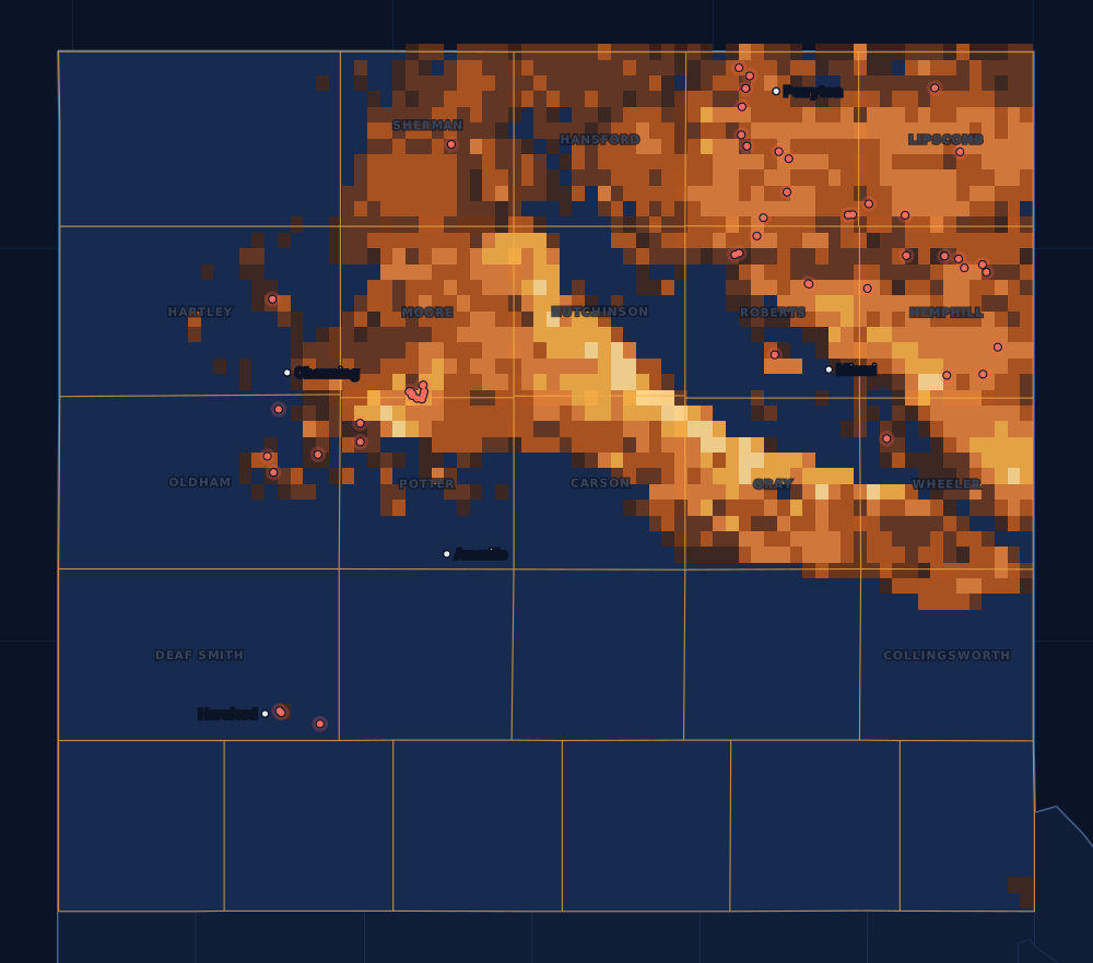
A tight sand play of the Texas Panhandle and western Oklahoma, about 160 miles long and 30 miles wide. It gives oil and gas, and is drilled sideways like the shales.
Counties
The 26 counties, by permits
Drilling permits of the last 12 months in each county, and the wells on the state's map there. Each county's live map shows every well and permit where the state puts it.
- 1Hemphill County153,417 wells on the mapLive map
- 2Ochiltree County122,417 wells on the mapLive map
- 3Roberts County101,605 wells on the mapLive map
- 4Moore County92,888 wells on the mapLive map
- 5Potter County51,356 wells on the mapLive map
- 6Lipscomb County42,464 wells on the mapLive map
- 7Oldham County4124 wells on the mapLive map
- 8Deaf Smith County41 wells on the mapLive map
- 9Wheeler County12,805 wells on the mapLive map
- 10Sherman County11,022 wells on the mapLive map
- 11Hartley County1167 wells on the mapLive map
- 12Hutchinson County05,412 wells on the mapLive map
- 13Gray County05,054 wells on the mapLive map
- 14Carson County02,466 wells on the mapLive map
- 15Hansford County0997 wells on the mapLive map
- 16Collingsworth County0377 wells on the mapLive map
The other 10 counties, A to Z
- Armstrong County0 permits · 0 wells
- Briscoe County0 permits · 0 wells
- Castro County0 permits · 0 wells
- Childress County0 permits · 5 wells
- Dallam County0 permits · 2 wells
- Donley County0 permits · 9 wells
- Hall County0 permits · 0 wells
- Parmer County0 permits · 0 wells
- Randall County0 permits · 0 wells
- Swisher County0 permits · 0 wells
Operators
Who files the permits
The companies with the most drilling permits in the play's counties in the last 12 months, as the state names them.
FAQ
Questions people ask
Is my land in the Granite Wash?
This page counts every well and permit in the 26 counties the Railroad Commission lists for the Granite Wash. A county on the list does not mean the formation lies under every tract in it, or that a well will be drilled on yours. Your county's live map shows the wells and permits around your land, and the operator's division order says which well pays you.
What does the heat on the map show?
Every well on the state's map, counted in squares about two and a half miles wide: the brighter the square, the more wells in it. It shows where drilling has been, old wells included. The red dots are the drilling permits of the last twelve months that have a location on file: where drilling is going now.
Why are some years so different?
Drilling follows prices and the industry's spending. The bars count wells by the completion date the state has on file; the newest months fill in as operators file their completion reports, so the current year is drawn lighter.
Does a permit mean royalties?
No. A permit is permission to drill, not a well, and many are drilled months later or never. Royalties start after a well is completed, produces and the operator sets up its division order. If you own minerals in one of these counties, the first check is usually due about four months after first sales.
Sources
- Railroad Commission of Texas, Granite Wash (the play and its affected counties)www.rrc.texas.gov/oil-and-gas/major-oil-and-gas-formations/granite-wash/ · read November 14, 2026
- Railroad Commission of Texas, major oil and gas formationswww.rrc.texas.gov/oil-and-gas/major-oil-and-gas-formations/ · read November 14, 2026
- Railroad Commission of Texas, well layers, completion records and drilling permit fileswww.rrc.texas.gov/resource-center/research/data-sets-available-for-download/ · loaded as the state publishes them; figures kept six hours
- US Census Bureau, cartographic boundary files (county lines), through the us-atlas package 3.0.1www.census.gov/geographies/mapping-files/time-series/geo/cartographic-boundary.html · built into the site with its well maps
- GeoNames, towns and their points (CC BY 4.0)www.geonames.org/ · built into the site with its town pages