
Maverick County, Texas
Maverick County drilling permits: what the state recorded
- 21drilling permits
- 9completions
- 0first-production reports
- in the last twelve months
Wells by coordinates
Oil wells and drilling locations in Maverick County
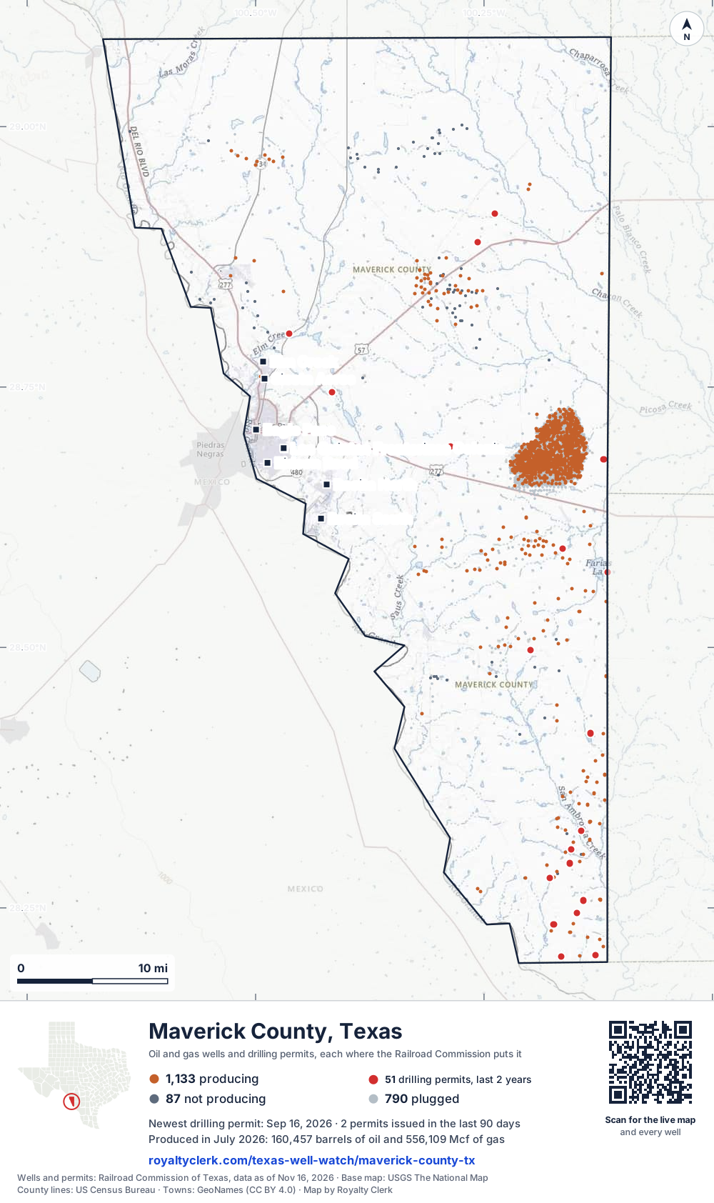
- Drilling locations51Permits issued in the last two years
- Producing wells1,133On a lease reporting production now
- Not producing87Shut in, inactive or no lease on record
- Plugged790The state's wellbore record says plugged
Sources: Railroad Commission of Texas well layers and permit files, US Census Bureau county outline, town points from GeoNames (CC BY 4.0), base map from USGS The National Map. A dot is a surface location; a horizontal well runs a mile or more from it.
2,010 wells with a location on the state's map and 51 drilling locations permitted in the last 24 months, each where the Railroad Commission puts it.
A permit is not a well.
Maverick County is one of the 27 counties of the Eagle Ford Shale
Wells near each town in Maverick County
- Eagle Pass15 wells
- Eidson Road7 wells
- Elm Creek20 wells
- Las Quintas Fronterizas9 wells
- Las Quintas Fronterizas Colonia9 wells
- Rosita North22 wells
- Rosita South22 wells
- Siesta Acres20 wells
Wells within 10 miles of each town, on either side of the county line.
Use this map on your site
You may show this map on any site, unchanged. Keep the credit line and its link to Royalty Clerk under the map. The picture updates by itself as the state records new wells and permits.
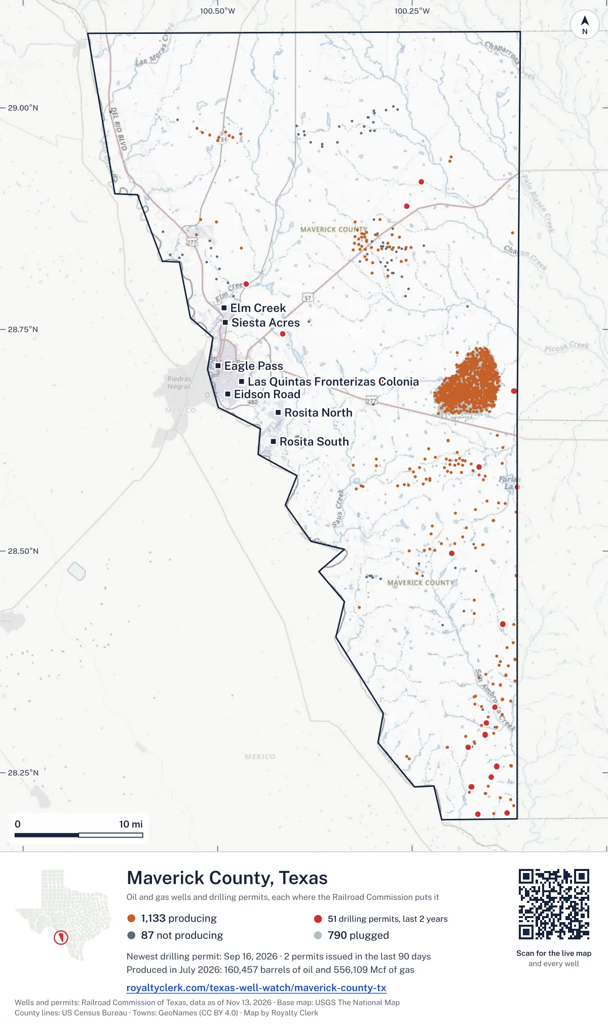
<a href="https://royaltyclerk.com/texas-well-watch/maverick-county-tx"><img src="https://royaltyclerk.com/maps/county-wells/maverick-county-tx.svg" alt="Map of Maverick County, Texas, with 2,010 oil and gas wells and 51 recent drilling locations as dots." width="1000" height="1684" loading="lazy" style="max-width:100%;height:auto;border:0"></a>
<p style="margin:4px 0 0;font-size:14px">Map: <a href="https://royaltyclerk.com/texas-well-watch/maverick-county-tx">Maverick County, Texas oil and gas wells</a> by Royalty Clerk, from Railroad Commission of Texas records</p>
The last twelve months
Month by month in Maverick County
| Month | Permits | Completions | First production |
|---|---|---|---|
| Sep 2026 | 2 | 0 | 0 |
| Aug 2026 | 0 | 1 | 0 |
| Jul 2026 | 0 | 1 | 0 |
| Jun 2026 | 4 | 4 | 0 |
| May 2026 | 9 | 0 | 0 |
| Apr 2026 | 3 | 0 | 0 |
| Feb 2026 | 1 | 0 | 0 |
| Jan 2026 | 2 | 0 | 0 |
| Nov 2025 | 0 | 3 | 0 |
Counted from November 15, 2025 to September 16, 2026, so the first and last months are partial. Source: Railroad Commission of Texas data sets.
Free, no sign-in
The newest drilling permits in Maverick County
| Issued | Lease and well | Operator | Drilling began | Depth, ft | API number | Coordinates | Permit |
|---|---|---|---|---|---|---|---|
| 2026-09-16 | CP#26-162 CATHODIC PROTECTION 44new drill · verticalTexas Pipeline LLCAPI 42-323-33700 · permit 091866528.49751, -100.19875300 ft | Texas Pipeline LLC | |||||
| 2026-09-16 | CP# 26-161 43new drill · verticalTexas Pipeline LLCAPI 42-323-33701 · permit 091866728.74506, -100.41639300 ft | Texas Pipeline LLC | |||||
| 2026-06-19 | COMANCHE 1513Hnew drill · horizontalEl Toro Resources LLCAPI 42-323-33699 · permit 091656128.57249, -100.11478drilling began 2026-08-11 · 4,300 ft | El Toro Resources LLC | |||||
| 2026-06-19 | COMANCHE 1512Hnew drill · horizontalEl Toro Resources LLCAPI 42-323-33698 · permit 091656028.57249, -100.11487drilling began 2026-08-11 · 4,300 ft | El Toro Resources LLC | |||||
| 2026-06-19 | COMANCHE 1511Hnew drill · horizontalEl Toro Resources LLCAPI 42-323-33697 · permit 091655928.57249, -100.11497drilling began 2026-08-11 · 4,300 ft | El Toro Resources LLC | |||||
| 2026-06-09 | CP# 26-105 CATHODIC PROTECTION 37new drill · verticalTexas Pipeline LLCAPI 42-323-33696 · permit 091621428.80154, -100.46308330 ft | Texas Pipeline LLC | |||||
| 2026-05-21 | CHITTIM HEIRS B 20Hnew drill · horizontalBlackbrush O & G, LLCAPI 42-323-33694 · permit 091583128.68057, -100.11918drilling began 2026-05-24 · 4,800 ft | Blackbrush O & G, LLC | |||||
| 2026-05-21 | CHITTIM HEIRS A 19Hnew drill · horizontalBlackbrush O & G, LLCAPI 42-323-33695 · permit 091581728.68057, -100.11925drilling began 2026-05-26 · 4,800 ft | Blackbrush O & G, LLC | |||||
| 2026-05-08 | CHITTIM 404new drill · verticalBlackbrush O & G, LLCAPI 42-323-33693 · permit 091543928.68058, -100.11887drilling began 2026-05-12 · 10,000 ft | Blackbrush O & G, LLC | |||||
| 2026-05-06 | SERENA RANCH 6308Hnew drill · horizontalJonah Energy LLCAPI 42-323-33692 · permit 091539128.30603, -100.15469drilling began 2026-06-03 · 3,999 ft | Jonah Energy LLC | |||||
| 2026-05-06 | SERENA RANCH 6306Hnew drill · horizontalJonah Energy LLCAPI 42-323-33691 · permit 091539028.30598, -100.15472drilling began 2026-06-03 · 3,999 ft | Jonah Energy LLC | |||||
| 2026-05-06 | SERENA RANCH 6304Hnew drill · horizontalJonah Energy LLCAPI 42-323-33690 · permit 091538728.30592, -100.15474drilling began 2026-06-04 · 3,999 ft | Jonah Energy LLC | |||||
| 2026-05-06 | SERENA RANCH 6302Hnew drill · horizontalJonah Energy LLCAPI 42-323-33689 · permit 091538528.30587, -100.15476drilling began 2026-06-04 · 3,999 ft | Jonah Energy LLC | |||||
| 2026-05-04 | SERENA RANCH 6206Hnew drill · horizontalJonah Energy LLCAPI 42-323-33688 · permit 091527128.32376, -100.14358drilling began 2026-07-04 · 3,999 ft | Jonah Energy LLC | |||||
| 2026-05-04 | SERENA RANCH 6204Hnew drill · horizontalJonah Energy LLCAPI 42-323-33687 · permit 091525128.32374, -100.14364drilling began 2026-07-05 · 3,999 ft | Jonah Energy LLC | |||||
| 2026-04-29 | SERENA RANCH 6202Hnew drill · horizontalJonah Energy LLCAPI 42-323-33686 · permit 091516728.32373, -100.14370drilling began 0202-07-05 · 3,999 ft | Jonah Energy LLC | |||||
| 2026-04-20 | GLASS RANCH 6006Hnew drill · horizontalJonah Energy LLCAPI 42-323-33685 · permit 091478228.41756, -100.13356drilling began 2026-05-11 · 3,999 ft | Jonah Energy LLC | |||||
| 2026-04-20 | GLASS RANCH 6004Hnew drill · horizontalJonah Energy LLCAPI 42-323-33684 · permit 091478128.41751, -100.13355drilling began 2026-05-09 · 3,999 ft | Jonah Energy LLC | |||||
| 2026-02-02 | CHITTIM HEIRS 7702new drill · verticalBlackbrush O & G, LLCAPI 42-323-33683 · permit 091303228.91643, -100.23845drilling began 2026-02-20 · 3,100 ft | Blackbrush O & G, LLC | |||||
| 2026-01-30 | CAGE A 1302Hnew drill · horizontalEndeavor Natural Gas, LPAPI 42-323-33682 · permit 091300028.20341, -100.16536drilling began 2026-03-14 · 4,000 ft | Endeavor Natural Gas, LP | |||||
| 2026-01-30 | CAGE A 1301Hnew drill · horizontalEndeavor Natural Gas, LPAPI 42-323-33681 · permit 091299928.20342, -100.16541drilling began 2026-03-14 · 4,000 ft | Endeavor Natural Gas, LP | |||||
| 2025-08-28 | COMANCHE 8145Hnew drill · horizontalEl Toro Resources LLCAPI 42-323-33680 · permit 091006028.59476, -100.16369drilling began 2025-10-24 · 4,000 ft | El Toro Resources LLC | |||||
| 2025-08-28 | COMANCHE 8144Hnew drill · horizontalEl Toro Resources LLCAPI 42-323-33679 · permit 091005828.59471, -100.16376drilling began 2025-10-25 · 4,000 ft | El Toro Resources LLC | |||||
| 2025-08-28 | COMANCHE 8143Hnew drill · horizontalEl Toro Resources LLCAPI 42-323-33678 · permit 091005728.59466, -100.16384drilling began 2025-10-26 · 4,000 ft | El Toro Resources LLC | |||||
| 2025-07-21 | CHITTIM HEIRS 401Hnew drill · horizontalBlackbrush O & G, LLCAPI 42-323-33676 · permit 090932928.69274, -100.286607,200 ft | Blackbrush O & G, LLC | |||||
| 2025-05-07 | SAN PEDRO RANCH 3901Hnew drill · horizontalGrit Oil & Gas Management, LLCAPI 42-323-33675 · permit 090775528.25699, -100.14140drilling began 2025-05-27 · 3,999 ft | Grit Oil & Gas Management, LLC | |||||
| 2025-05-05 | SERENA RANCH - INDIO D 3902Hnew drill · horizontalGrit Oil & Gas Management, LLCAPI 42-323-33674 · permit 090775328.25709, -100.14145drilling began 2025-05-26 · 3,999 ft | Grit Oil & Gas Management, LLC | |||||
| 2025-05-05 | SAN PEDRO RANCH 3903Hnew drill · horizontalGrit Oil & Gas Management, LLCAPI 42-323-33673 · permit 090775128.25704, -100.14143drilling began 2025-05-25 · 3,999 ft | Grit Oil & Gas Management, LLC | |||||
| 2025-05-05 | SERENA RANCH 3904Hnew drill · horizontalGrit Oil & Gas Management, LLCAPI 42-323-33672 · permit 090775028.25714, -100.14148drilling began 2025-05-26 · 3,999 ft | Grit Oil & Gas Management, LLC | |||||
| 2025-04-17 | SAN PEDRO RANCH 1017Hnew drill · horizontalGrit Oil & Gas Management, LLCAPI 42-323-33670 · permit 090745028.24492, -100.14809drilling began 2025-05-01 · 3,999 ft | Grit Oil & Gas Management, LLC | |||||
| 2025-04-17 | SAN PEDRO RANCH 1015Hnew drill · horizontalGrit Oil & Gas Management, LLCAPI 42-323-33671 · permit 090744928.24488, -100.14807drilling began 2025-04-30 · 3,999 ft | Grit Oil & Gas Management, LLC | |||||
| 2025-04-17 | SAN PEDRO RANCH 1013Hnew drill · horizontalGrit Oil & Gas Management, LLCAPI 42-323-33669 · permit 090744328.24484, -100.14805drilling began 2025-05-01 · 3,999 ft | Grit Oil & Gas Management, LLC | |||||
| 2025-04-17 | SERENA RANCH 1012Hnew drill · horizontalGrit Oil & Gas Management, LLCAPI 42-323-33668 · permit 090743928.24496, -100.14810drilling began 2025-04-29 · 3,999 ft | Grit Oil & Gas Management, LLC | |||||
| 2025-04-17 | SERENA RANCH-INDIO C 1014Hnew drill · horizontalGrit Oil & Gas Management, LLCAPI 42-323-33667 · permit 090743328.24499, -100.14812drilling began 2025-04-30 · 3,999 ft | Grit Oil & Gas Management, LLC | |||||
| 2025-04-10 | CHITTIM 96 1new drill · verticalEsco Oil Operating Company LLCAPI 42-323-33666 · permit 090728428.88885, -100.25716drilling began 2025-04-21 · 2,500 ft | Esco Oil Operating Company LLC | |||||
| 2025-01-31 | CAGE A 1021Hnew drill · horizontalEndeavor Natural Gas, LPAPI 42-323-33664 · permit 090555028.23436, -100.17371drilling began 2025-03-20 · 4,000 ft | Endeavor Natural Gas, LP | |||||
| 2025-01-30 | CAGE A 1022Hnew drill · horizontalEndeavor Natural Gas, LPAPI 42-323-33665 · permit 090555128.23437, -100.17376drilling began 2025-03-22 · 4,000 ft | Endeavor Natural Gas, LP | |||||
| 2025-01-15 | FAITH-STATE-RINCON 'C' UNIT 3Hnew drill · horizontalStrand Energy, L.c.API 42-323-33662 · permit 090515128.20432, -100.12772drilling began 2025-02-08 · 4,000 ft | Strand Energy, L.c. | |||||
| 2025-01-14 | FAITH-STATE-RINCON 'C' UNIT 4Hnew drill · horizontalStrand Energy, L.c.API 42-323-33663 · permit 090515228.20435, -100.12769drilling began 2025-02-09 · 4,000 ft | Strand Energy, L.c. | |||||
| 2025-01-14 | FAITH-STATE-RINCON 'C' UNIT 2Hnew drill · horizontalStrand Energy, L.c.API 42-323-33661 · permit 090515028.20440, -100.12762drilling began 2025-02-11 · 4,000 ft | Strand Energy, L.c. | |||||
| 2025-01-14 | FAITH-STATE-RINCON 'C' UNIT 1Hnew drill · horizontalStrand Energy, L.c.API 42-323-33660 · permit 090514828.20438, -100.12765drilling began 2025-02-10 · 4,000 ft | Strand Energy, L.c. | |||||
| 2024-12-17 | GLASS RANCH 6005Hnew drill · horizontalGrit Oil & Gas Management, LLCAPI 42-323-33659 · permit 090465128.41788, -100.13361drilling began 2025-01-25 · 3,999 ft | Grit Oil & Gas Management, LLC | |||||
| 2024-12-17 | GLASS RANCH 6003Hnew drill · horizontalGrit Oil & Gas Management, LLCAPI 42-323-33658 · permit 090465028.41787, -100.13367drilling began 2025-01-25 · 3,999 ft | Grit Oil & Gas Management, LLC | |||||
| 2024-12-17 | GLASS RANCH 6002Hnew drill · horizontalGrit Oil & Gas Management, LLCAPI 42-323-33657 · permit 090464928.41786, -100.13380drilling began 2025-01-24 · 3,999 ft | Grit Oil & Gas Management, LLC | |||||
| 2024-12-13 | GLASS RANCH 6001Hnew drill · horizontalGrit Oil & Gas Management, LLCAPI 42-323-33656 · permit 090464828.41786, -100.13373drilling began 2025-01-25 · 3,999 ft | Grit Oil & Gas Management, LLC | |||||
| 2024-12-06 | SERENA RANCH 7804Hnew drill · horizontalGrit Oil & Gas Management, LLCAPI 42-323-33655 · permit 090448828.29274, -100.15593drilling began 2024-12-14 · 3,999 ft | Grit Oil & Gas Management, LLC | |||||
| 2024-12-06 | SERENA RANCH-INDIO B 7805Hnew drill · horizontalGrit Oil & Gas Management, LLCAPI 42-323-33654 · permit 090432328.29290, -100.15588drilling began 2024-12-12 · 3,999 ft | Grit Oil & Gas Management, LLC | |||||
| 2024-12-06 | SERENA RANCH-INDIO A 7803Hnew drill · horizontalGrit Oil & Gas Management, LLCAPI 42-323-33653 · permit 090432228.29284, -100.15590drilling began 2024-12-14 · 3,999 ft | Grit Oil & Gas Management, LLC | |||||
| 2024-12-03 | SERENA RANCH 7602recompletion · verticalGrit Oil & Gas Management, LLCAPI 42-323-33479 · permit 090434228.27904, -100.17780drilling began 2017-02-18 · 3,999 ft | Grit Oil & Gas Management, LLC | |||||
| 2024-12-03 | SERENA RANCH 7801Hnew drill · horizontalGrit Oil & Gas Management, LLCAPI 42-323-33652 · permit 090432128.29279, -100.15592drilling began 2024-12-13 · 3,999 ft | Grit Oil & Gas Management, LLC |
These are the newest 50 of 77 permits on file for Maverick County. The rest follow, 50 to a page.
A permit is permission to drill, not a well. Source: Railroad Commission of Texas drilling permit files.
Year by year
Drilling permits issued in Maverick County, by year
| Year | Permits issued |
|---|---|
| 2026 so far | 21 |
| 2025 | 20 |
| 2024 | 34 |
| 2023 | 2 |
Counted from the permit files we hold, which start in 2023; that first year may be partial. Source: Railroad Commission of Texas drilling permit files.
The latest
The most recent records
| Date | What, who and where |
|---|---|
| 2026-09-16 | Permit issued: Texas Pipeline LLCCP# 26-161 · A-359 · permit 0918667 |
| 2026-09-16 | Permit issued: Texas Pipeline LLCCP#26-162 CATHODIC PROTECTION · A-788 · permit 0918665 |
| 2026-08-06 | Completed: Blackbrush O & G, LLCCHITTIM HEIRS · A-279 · permit 0913032 |
| 2026-07-20 | Completed: Jonah Energy LLCGLASS RANCH · A-788 · permit 0914781 |
| 2026-06-19 | Permit issued: El Toro Resources LLCCOMANCHE · A-151 · permit 0916561 |
| 2026-06-19 | Permit issued: El Toro Resources LLCCOMANCHE · A-151 · permit 0916560 |
| 2026-06-19 | Permit issued: El Toro Resources LLCCOMANCHE · A-151 · permit 0916559 |
| 2026-06-17 | Completed: Blackbrush O & G, LLCCHITTIM HEIRS B · A-1011 · permit 0915831 |
| 2026-06-09 | Permit issued: Texas Pipeline LLCCP# 26-105 CATHODIC PROTECTION · A-1088 · permit 0916214 |
| 2026-06-07 | Completed: Endeavor Natural Gas, LPCAGE A · A-788 · permit 0913000 |
| 2026-06-06 | Completed: Endeavor Natural Gas, LPCAGE A · A-788 · permit 0912999 |
| 2026-06-04 | Completed: Blackbrush O & G, LLCCHITTIM HEIRS A · A-1011 · permit 0915817 |
| 2026-05-21 | Permit issued: Blackbrush O & G, LLCCHITTIM HEIRS A · A-1011 · permit 0915817 |
| 2026-05-21 | Permit issued: Blackbrush O & G, LLCCHITTIM HEIRS B · A-1011 · permit 0915831 |
| 2026-05-08 | Permit issued: Blackbrush O & G, LLCCHITTIM · A-1011 · permit 0915439 |
Follow it
Watch Maverick County, or one abstract
What do you want to follow?
Where the land is. Your deed or lease names it.
For example A-1119, or Bush, or T&P 38. Your deed or the tax bill has it.
Other counties
Drilling activity in other counties
Related
Related
- ToolTexas well watchPermit, completion, first production and when the first check is due.
- ToolIs this buyout offer fair?The offer as months of your income, what the acres mean, and the questions to ask.
- ToolIs this lease offer good?Bonus and royalty against the county, and a scan of the lease's clauses.
- Texas dataTexas operator changesWho took over whose leases in the last 24 months.
- ToolLate payment interestDeadlines and the interest a late payment earns.
- Texas dataTexas oil and gas atlas254 counties, every lease, operator and field.
FAQ
Questions people ask
How many wells were permitted in Maverick County in the last year?
The Railroad Commission issued 21 drilling permits in Maverick County in the twelve months to September 16, 2026, and recorded 9 completions and 0 first-production reports. A permit is permission to drill, not a well.
How do I get an alert when a permit is issued near my land in Maverick County?
Choose your abstract on this page, or the whole county, and sign in. You get one email a week, only when something new is recorded after you sign up. The alert says whether an event is on an interest in your Mineral File, on a place you follow, or only nearby.
When is my first royalty check due after a new well?
Natural Resources Code section 91.402(a) says on or before 120 days after the end of the month of first sale of production from the well. The state's first-production month is the closest public marker, so the date on this page is the earliest, not a certainty.
Got a new well on your land?
The first check is due within 120 days after the end of the month of first sale.
Sources
Primary sources, opened on 29 September 2026. Statute text is the current version on statutes.capitol.texas.gov.