
Moore County, Texas
Moore County drilling permits: what the state recorded
- 9drilling permits
- 6completions
- 0first-production reports
- in the last twelve months
Wells by coordinates
Oil wells and drilling locations in Moore County
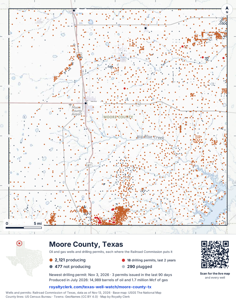
- Drilling locations18Permits issued in the last two years
- Producing wells2,121On a lease reporting production now
- Not producing477Shut in, inactive or no lease on record
- Plugged290The state's wellbore record says plugged
Sources: Railroad Commission of Texas well layers and permit files, US Census Bureau county outline, town points from GeoNames (CC BY 4.0), base map from USGS The National Map. A dot is a surface location; a horizontal well runs a mile or more from it.
2,888 wells with a location on the state's map and 18 drilling locations permitted in the last 24 months, each where the Railroad Commission puts it.
A permit is not a well.
Wells near each town in Moore County
Wells within 10 miles of each town, on either side of the county line.
Use this map on your site
You may show this map on any site, unchanged. Keep the credit line and its link to Royalty Clerk under the map. The picture updates by itself as the state records new wells and permits.
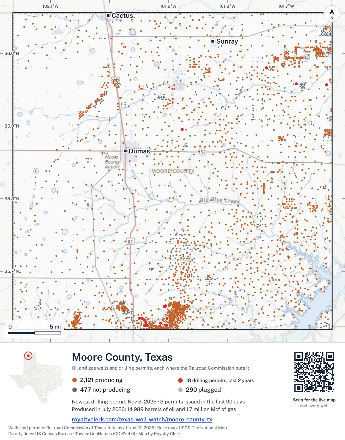
<a href="https://royaltyclerk.com/texas-well-watch/moore-county-tx"><img src="https://royaltyclerk.com/maps/county-wells/moore-county-tx.svg" alt="Map of Moore County, Texas, with 2,888 oil and gas wells and 18 recent drilling locations as dots." width="1000" height="1276" loading="lazy" style="max-width:100%;height:auto;border:0"></a>
<p style="margin:4px 0 0;font-size:14px">Map: <a href="https://royaltyclerk.com/texas-well-watch/moore-county-tx">Moore County, Texas oil and gas wells</a> by Royalty Clerk, from Railroad Commission of Texas records</p>
The last twelve months
Month by month in Moore County
| Month | Permits | Completions | First production |
|---|---|---|---|
| Nov 2026 | 1 | 0 | 0 |
| Oct 2026 | 2 | 0 | 0 |
| Aug 2026 | 0 | 3 | 0 |
| Jun 2026 | 0 | 1 | 0 |
| May 2026 | 3 | 2 | 0 |
| Apr 2026 | 2 | 0 | 0 |
| Mar 2026 | 1 | 0 | 0 |
Counted from November 15, 2025 to November 3, 2026, so the first and last months are partial. Source: Railroad Commission of Texas data sets.
Free, no sign-in
The newest drilling permits in Moore County
| Issued | Lease and well | Operator | Drilling began | Depth, ft | API number | Coordinates | Permit |
|---|---|---|---|---|---|---|---|
| 2026-11-03 | MASTERSON G 7613new drill · verticalBerexco LLCAPI 42-341-33783 · permit 091976435.63538, -101.949152,400 ft | Berexco LLC | |||||
| 2026-10-29 | MASTERSON G 7433new drill · verticalBerexco LLCAPI 42-341-33782 · permit 091976235.62536, -101.940252,400 ft | Berexco LLC | |||||
| 2026-10-29 | MASTERSON ESTATE 108new drill · verticalBeren CorporationAPI 42-341-33784 · permit 091976735.62586, -101.904782,400 ft | Beren Corporation | |||||
| 2026-05-26 | MASTERSON 'B' 5new drill · verticalBeren CorporationAPI 42-341-33781 · permit 091579535.63534, -101.90222drilling began 2026-06-12 · 2,400 ft | Beren Corporation | |||||
| 2026-05-22 | MASTERSON ESTATE 107new drill · verticalBeren CorporationAPI 42-341-33780 · permit 091579235.62911, -101.93820drilling began 2026-06-08 · 2,400 ft | Beren Corporation | |||||
| 2026-05-22 | MASTERSON G 7612new drill · verticalBerexco LLCAPI 42-341-33779 · permit 091576335.63536, -101.94471drilling began 2026-06-05 · 2,400 ft | Berexco LLC | |||||
| 2026-04-29 | THOMPSON 13new drill · verticalP & F Operating, LLCAPI 42-341-33778 · permit 091515935.65247, -101.90479drilling began 2026-05-18 · 3,000 ft | P & F Operating, LLC | |||||
| 2026-04-10 | THOMPSON 16new drill · verticalP & F Operating, LLCAPI 42-341-33777 · permit 091366635.65132, -101.907003,000 ft | P & F Operating, LLC | |||||
| 2026-03-23 | THOMPSON 15new drill · verticalP & F Operating, LLCAPI 42-341-33776 · permit 091365735.65130, -101.90589drilling began 2026-05-13 · 3,000 ft | P & F Operating, LLC | |||||
| 2025-08-05 | MCDOWELL 16field transfer · verticalScout Energy Management LLCAPI 42-341-32167 · permit 090950035.95690, -101.631373,368 ft | Scout Energy Management LLC | |||||
| 2025-06-17 | STRUNK 2new drill · verticalPantera Energy CompanyAPI 42-341-33775 · permit 090863635.89560, -101.87651drilling began 2025-07-21 · 3,500 ft | Pantera Energy Company | |||||
| 2025-04-14 | MASTERSON ESTATE 28recompletion · verticalBeren CorporationAPI 42-341-00723 · permit 090717735.62890, -101.91373drilling began 1962-06-27 · 3,550 ft | Beren Corporation | |||||
| 2025-04-03 | MASTERSON ESTATE 160Rreclass · verticalBeren CorporationAPI 42-341-32639 · permit 090598535.63312, -101.941302,422 ft | Beren Corporation | |||||
| 2025-03-27 | MASTERSON G 7432new drill · verticalBerexco LLCAPI 42-341-33774 · permit 090673635.62535, -101.93803drilling began 2025-04-13 · 2,400 ft | Berexco LLC | |||||
| 2025-03-24 | MASTERSON ESTATE 106new drill · verticalBeren CorporationAPI 42-341-33773 · permit 090673535.62586, -101.90257drilling began 2025-04-19 · 2,400 ft | Beren Corporation | |||||
| 2025-03-19 | MASTERSON G 7431new drill · verticalBerexco LLCAPI 42-341-33772 · permit 090650335.62535, -101.93581drilling began 2025-04-09 · 2,400 ft | Berexco LLC | |||||
| 2025-03-06 | KATE 5new drill · verticalJ. W. Resources Inc.API 42-341-33771 · permit 090631335.97994, -101.73305drilling began 2025-03-15 · 6,000 ft | J. W. Resources Inc. | |||||
| 2025-01-17 | MADOC 1new drill · verticalJ. W. Resources Inc.API 42-341-33770 · permit 090516635.95810, -101.68301drilling began 2025-02-03 · 6,000 ft | J. W. Resources Inc. | |||||
| 2024-08-08 | READ S 2recompletion · horizontalScout Energy Management LLCAPI 42-341-33669 · permit 090141635.68125, -101.73087drilling began 2022-09-30 · 3,100 ft | Scout Energy Management LLC | |||||
| 2024-07-26 | READ 1Arecompletion · horizontalScout Energy Management LLCAPI 42-341-33533 · permit 090148835.68212, -101.76266drilling began 2019-05-12 · 3,151 ft | Scout Energy Management LLC | |||||
| 2024-07-25 | FEE S 1recompletion · horizontalScout Energy Management LLCAPI 42-341-33581 · permit 090148435.67241, -101.701312,623 ft | Scout Energy Management LLC | |||||
| 2024-07-22 | READ S 1recompletion · horizontalScout Energy Management LLCAPI 42-341-33582 · permit 090141435.67548, -101.74303drilling began 2021-07-09 · 3,111 ft | Scout Energy Management LLC | |||||
| 2024-07-18 | READ S 14Arecompletion · horizontalScout Energy Management LLCAPI 42-341-33758 · permit 090131435.68173, -101.73864drilling began 2023-10-16 · 2,900 ft | Scout Energy Management LLC | |||||
| 2024-05-07 | BONNIE 1new drill · verticalScout Energy Management LLCAPI 42-341-33769 · permit 089951035.93499, -101.67060drilling began 2024-06-06 · 6,750 ft | Scout Energy Management LLC | |||||
| 2024-04-22 | MASTERSON G 7430new drill · verticalBerexco LLCAPI 42-341-33768 · permit 089891735.62532, -101.92693drilling began 2024-04-23 · 2,400 ft | Berexco LLC | |||||
| 2024-04-22 | MASTERSON G 7429new drill · verticalBerexco LLCAPI 42-341-33767 · permit 089891435.62534, -101.93359drilling began 2024-04-26 · 2,400 ft | Berexco LLC | |||||
| 2024-04-02 | MASTERSON G 7428new drill · verticalBerexco LLCAPI 42-341-33766 · permit 089805035.62353, -101.93135drilling began 2024-04-12 · 2,400 ft | Berexco LLC | |||||
| 2024-03-12 | MASTERSON ESTATE 105new drill · verticalBeren CorporationAPI 42-341-33765 · permit 089805235.63052, -101.94026drilling began 2024-04-04 · 2,400 ft | Beren Corporation | |||||
| 2024-03-11 | MASTERSON ESTATE 104new drill · verticalBeren CorporationAPI 42-341-33764 · permit 089804735.62530, -101.92249drilling began 2024-04-08 · 2,400 ft | Beren Corporation | |||||
| 2024-02-02 | BAIN 1new drill · verticalJ. W. Resources Inc.API 42-341-33763 · permit 089700035.97462, -101.720736,000 ft | J. W. Resources Inc. | |||||
| 2024-01-22 | KATE 2new drill · verticalJ. W. Resources Inc.API 42-341-33762 · permit 089643235.97691, -101.72287drilling began 2024-02-02 · 6,000 ft | J. W. Resources Inc. | |||||
| 2024-01-09 | KATE 4new drill · verticalJ. W. Resources Inc.API 42-341-33761 · permit 089640735.97838, -101.73049drilling began 2024-01-22 · 6,000 ft | J. W. Resources Inc. | |||||
| 2023-09-29 | READ S 47Bnew drill · verticalScout Energy Management LLCAPI 42-341-33760 · permit 089421835.67367, -101.77808drilling began 2023-10-31 · 4,000 ft | Scout Energy Management LLC | |||||
| 2023-09-29 | READ S 16Cnew drill · verticalScout Energy Management LLCAPI 42-341-33759 · permit 089417135.66662, -101.75621drilling began 2023-10-27 · 4,000 ft | Scout Energy Management LLC | |||||
| 2023-09-29 | READ S 14Anew drill · verticalScout Energy Management LLCAPI 42-341-33758 · permit 089404535.68173, -101.73864drilling began 2023-10-16 · 4,000 ft | Scout Energy Management LLC | |||||
| 2005-05-12 | G. L. TROUTMAN 1reclass · verticalScout Energy Management LLCAPI 42-341-31507 · permit 060060735.86756, -101.87568drilling began 1984-12-11 · 3,600 ft | Scout Energy Management LLC |
A permit is permission to drill, not a well. Source: Railroad Commission of Texas drilling permit files.
Year by year
Drilling permits issued in Moore County, by year
| Year | Permits issued |
|---|---|
| 2026 so far | 9 |
| 2025 | 9 |
| 2024 | 14 |
| 2023 | 3 |
| 2005 | 1 |
Counted from the permit files we hold, which start in 2005; that first year may be partial. Source: Railroad Commission of Texas drilling permit files.
The latest
The most recent records
| Date | What, who and where |
|---|---|
| 2026-11-03 | Permit issued: Berexco LLCMASTERSON G · A-1544 · permit 0919764 |
| 2026-10-29 | Permit issued: Berexco LLCMASTERSON G · A-668 · permit 0919762 |
| 2026-10-29 | Permit issued: Beren CorporationMASTERSON ESTATE · A-788 · permit 0919767 |
| 2026-08-14 | Completed: Beren CorporationMASTERSON 'B' · A-405 · permit 0915795 |
| 2026-08-12 | Completed: Beren CorporationMASTERSON ESTATE · A-409 · permit 0915792 |
| 2026-08-11 | Completed: Berexco LLCMASTERSON G · A-1544 · permit 0915763 |
| 2026-06-09 | Completed: Beren CorporationMASTERSON ESTATE · A-788 · permit 0906735 |
| 2026-05-26 | Permit issued: Beren CorporationMASTERSON 'B' · A-405 · permit 0915795 |
| 2026-05-22 | Permit issued: Beren CorporationMASTERSON ESTATE · A-409 · permit 0915792 |
| 2026-05-22 | Permit issued: Berexco LLCMASTERSON G · A-1544 · permit 0915763 |
| 2026-05-01 | Completed: Berexco LLCMASTERSON G · A-668 · permit 0906503 |
| 2026-05-01 | Completed: Berexco LLCMASTERSON G · A-688 · permit 0906736 |
| 2026-04-29 | Permit issued: P & F Operating, LLCTHOMPSON · A-398 · permit 0915159 |
| 2026-04-10 | Permit issued: P & F Operating, LLCTHOMPSON · A-405 · permit 0913666 |
| 2026-03-23 | Permit issued: P & F Operating, LLCTHOMPSON · A-398 · permit 0913657 |
Coming up
First checks coming due in Moore County
- MASTERSON G, Berexco LLCby December 29, 2026
- MASTERSON ESTATE, Beren Corporationby December 29, 2026
- MASTERSON 'B', Beren Corporationby December 29, 2026
Follow it
Watch Moore County, or one abstract
What do you want to follow?
Where the land is. Your deed or lease names it.
For example A-1119, or Bush, or T&P 38. Your deed or the tax bill has it.
Other counties
Drilling activity in other counties
Related
Related
- ToolTexas well watchPermit, completion, first production and when the first check is due.
- ToolIs this buyout offer fair?The offer as months of your income, what the acres mean, and the questions to ask.
- ToolIs this lease offer good?Bonus and royalty against the county, and a scan of the lease's clauses.
- Texas dataTexas operator changesWho took over whose leases in the last 24 months.
- ToolLate payment interestDeadlines and the interest a late payment earns.
- Texas dataTexas oil and gas atlas254 counties, every lease, operator and field.
FAQ
Questions people ask
How many wells were permitted in Moore County in the last year?
The Railroad Commission issued 9 drilling permits in Moore County in the twelve months to November 3, 2026, and recorded 6 completions and 0 first-production reports. A permit is permission to drill, not a well.
How do I get an alert when a permit is issued near my land in Moore County?
Choose your abstract on this page, or the whole county, and sign in. You get one email a week, only when something new is recorded after you sign up. The alert says whether an event is on an interest in your Mineral File, on a place you follow, or only nearby.
When is my first royalty check due after a new well?
Natural Resources Code section 91.402(a) says on or before 120 days after the end of the month of first sale of production from the well. The state's first-production month is the closest public marker, so the date on this page is the earliest, not a certainty.
Got a new well on your land?
The first check is due within 120 days after the end of the month of first sale.
Sources
Primary sources, opened on 29 September 2026. Statute text is the current version on statutes.capitol.texas.gov.