
Ochiltree County, Texas
Ochiltree County drilling permits: what the state recorded
- 12drilling permits
- 8completions
- 3first-production reports
- in the last twelve months
Wells by coordinates
Oil wells and drilling locations in Ochiltree County
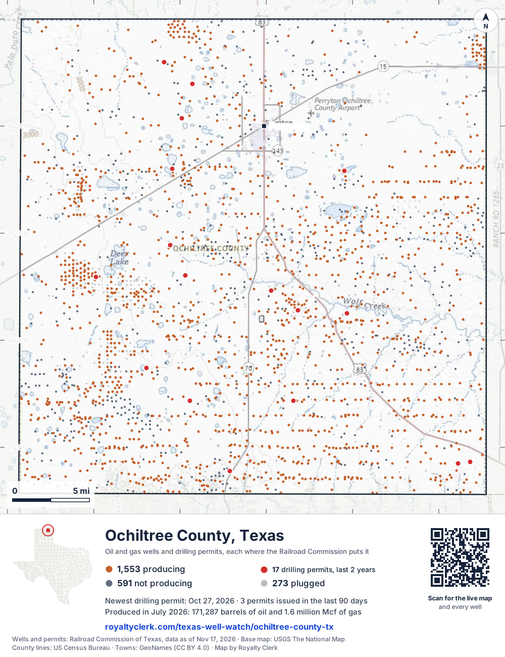
- Drilling locations17Permits issued in the last two years
- Producing wells1,554On a lease reporting production now
- Not producing591Shut in, inactive or no lease on record
- Plugged272The state's wellbore record says plugged
Sources: Railroad Commission of Texas well layers and permit files, US Census Bureau county outline, town points from GeoNames (CC BY 4.0), base map from USGS The National Map. A dot is a surface location; a horizontal well runs a mile or more from it.
2,417 wells with a location on the state's map and 17 drilling locations permitted in the last 24 months, each where the Railroad Commission puts it.
A permit is not a well.
Ochiltree County is one of the 26 counties of the Granite Wash
Wells near each town in Ochiltree County
Wells within 10 miles of each town, on either side of the county line.
Use this map on your site
You may show this map on any site, unchanged. Keep the credit line and its link to Royalty Clerk under the map. The picture updates by itself as the state records new wells and permits.
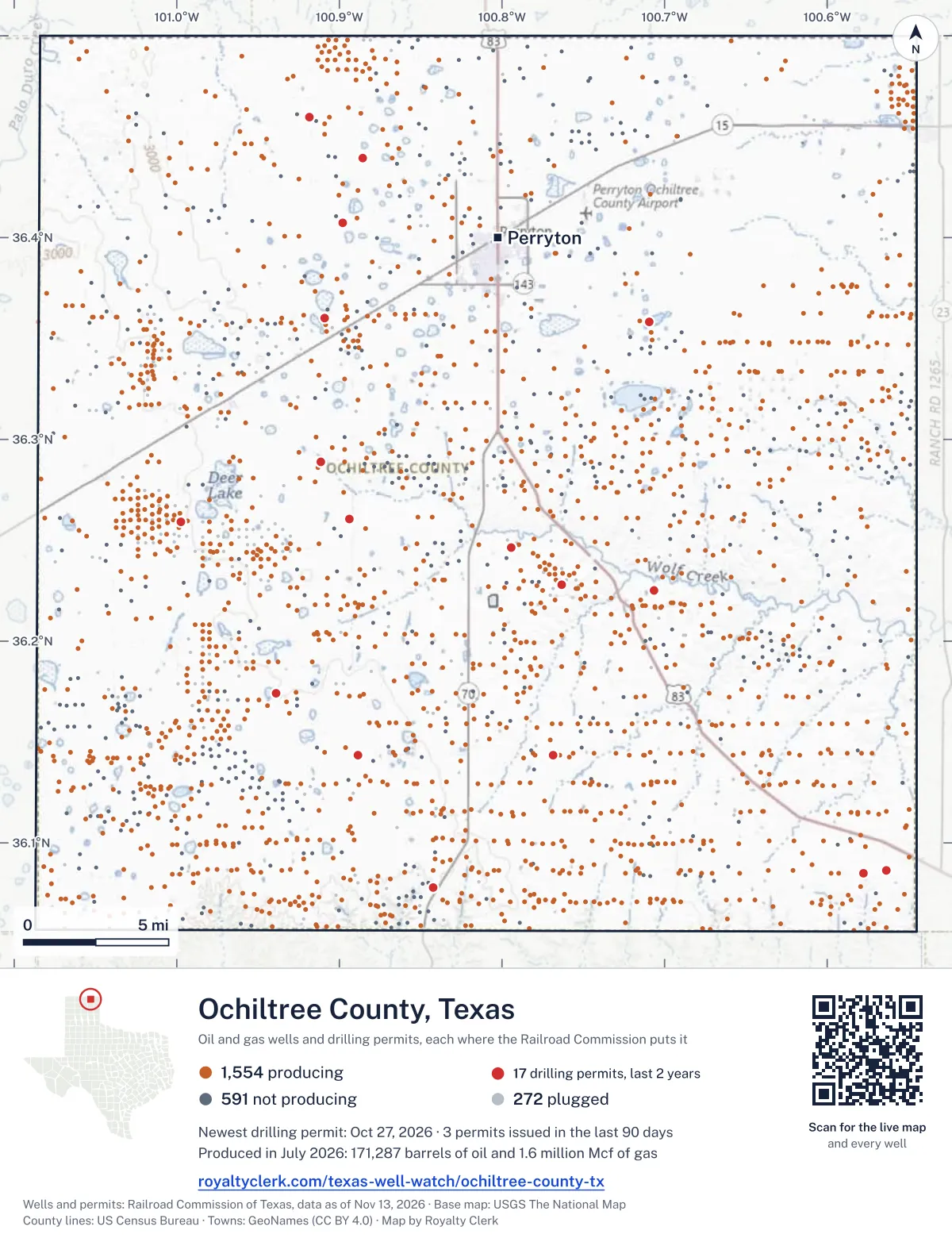
<a href="https://royaltyclerk.com/texas-well-watch/ochiltree-county-tx"><img src="https://royaltyclerk.com/maps/county-wells/ochiltree-county-tx.svg" alt="Map of Ochiltree County, Texas, with 2,417 oil and gas wells and 17 recent drilling locations as dots." width="1000" height="1300" loading="lazy" style="max-width:100%;height:auto;border:0"></a>
<p style="margin:4px 0 0;font-size:14px">Map: <a href="https://royaltyclerk.com/texas-well-watch/ochiltree-county-tx">Ochiltree County, Texas oil and gas wells</a> by Royalty Clerk, from Railroad Commission of Texas records</p>
The last twelve months
Month by month in Ochiltree County
| Month | Permits | Completions | First production |
|---|---|---|---|
| Oct 2026 | 3 | 0 | 0 |
| Aug 2026 | 2 | 0 | 0 |
| Jul 2026 | 0 | 1 | 1 |
| Jun 2026 | 1 | 0 | 0 |
| May 2026 | 2 | 0 | 0 |
| Apr 2026 | 1 | 4 | 1 |
| Mar 2026 | 2 | 1 | 0 |
| Jan 2026 | 0 | 1 | 1 |
| Dec 2025 | 1 | 0 | 0 |
| Nov 2025 | 0 | 1 | 0 |
Counted from November 15, 2025 to October 27, 2026, so the first and last months are partial. Source: Railroad Commission of Texas data sets.
Free, no sign-in
The newest drilling permits in Ochiltree County
| Issued | Lease and well | Operator | Drilling began | Depth, ft | API number | Coordinates | Permit |
|---|---|---|---|---|---|---|---|
| 2026-10-27 | HURNS 145 C001NCnew drill · horizontalMewbourne Oil CompanyAPI 42-357-33784 · permit 091962636.08488, -100.577628,141 ft | Mewbourne Oil Company | |||||
| 2026-10-22 | COURSON JINES 660 M001NCnew drill · horizontalMewbourne Oil CompanyAPI 42-357-33783 · permit 091950936.24631, -100.794097,385 ft | Mewbourne Oil Company | |||||
| 2026-10-19 | KENT 6570recompletion · verticalCourson Oil & Gas, Inc.API 42-357-33757 · permit 091931236.22815, -100.763215,872 ft | Courson Oil & Gas, Inc. | |||||
| 2026-08-18 | LANCE 2011recompletion · verticalCarson Buckles Exploration LLCAPI 42-357-31385 · permit 091736236.36036, -100.909368,500 ft | Carson Buckles Exploration LLC | |||||
| 2026-08-03 | MCLARTY-LAWRENCE 1Hnew drill · horizontalKing Operating CorporationAPI 42-357-33782 · permit 091751736.40718, -100.897899,000 ft | King Operating Corporation | |||||
| 2026-06-29 | THURMAN 23 1Hnew drill · horizontalKing Operating CorporationAPI 42-357-33781 · permit 091668636.28872, -100.911339,000 ft | King Operating Corporation | |||||
| 2026-05-29 | O'DELL 73 1Hnew drill · horizontalKing Operating CorporationAPI 42-357-33780 · permit 091590936.43923, -100.88545drilling began 2026-06-21 · 9,000 ft | King Operating Corporation | |||||
| 2026-05-27 | COURSON HARBAUGH 142/147 A C001JOnew drill · horizontalMewbourne Oil CompanyAPI 42-357-33779 · permit 091582736.07792, -100.84263drilling began 2026-06-19 · 7,471 ft | Mewbourne Oil Company | |||||
| 2026-04-30 | HALEY 102 1 Hnew drill · horizontalKing Operating CorporationAPI 42-357-33778 · permit 091519636.45981, -100.91868drilling began 2026-05-26 · 9,000 ft | King Operating Corporation | |||||
| 2026-03-31 | DICKENSON '307' C002APnew drill · horizontalMewbourne Oil CompanyAPI 42-357-33777 · permit 091437436.14329, -100.768377,700 ft | Mewbourne Oil Company | |||||
| 2026-03-09 | DAVIS 146 C002MDnew drill · horizontalMewbourne Oil CompanyAPI 42-357-33776 · permit 091377436.08615, -100.56375drilling began 2026-06-03 · 8,207 ft | Mewbourne Oil Company | |||||
| 2025-12-09 | PRESCOTT - IRVIN 4354HMnew drill · horizontalKing Operating CorporationAPI 42-357-33775 · permit 091204836.26037, -100.89378drilling began 2026-04-22 · 9,000 ft | King Operating Corporation | |||||
| 2025-10-13 | FARNSWORTH UNIT 2003recompletion · verticalCapturepoint LLCAPI 42-357-02381 · permit 090972536.25895, -100.99775drilling began 1956-12-31 · 7,949 ft | Capturepoint LLC | |||||
| 2025-09-30 | COURSON HERNDON 567/578 A C001EDnew drill · horizontalMewbourne Oil CompanyAPI 42-357-33774 · permit 091067136.22513, -100.70679drilling began 2025-11-01 · 7,308 ft | Mewbourne Oil Company | |||||
| 2025-09-05 | PETERSON J 4recompletion · verticalJ-Brex CompanyAPI 42-357-33760 · permit 091021836.35844, -100.709438,827 ft | J-Brex Company | |||||
| 2025-01-17 | COURSON WERMSKE 89 A C001CNnew drill · horizontalMewbourne Oil CompanyAPI 42-357-33773 · permit 090519536.17417, -100.93870drilling began 2025-02-11 · 7,130 ft | Mewbourne Oil Company | |||||
| 2025-01-16 | COURSON SHIELDKNIGHT 101 C001NCnew drill · horizontalMewbourne Oil CompanyAPI 42-357-33772 · permit 090512536.14358, -100.88879drilling began 2026-03-11 · 7,277 ft | Mewbourne Oil Company | |||||
| 2024-10-09 | ROY LINN 580 C002PBnew drill · horizontalMewbourne Oil CompanyAPI 42-357-33771 · permit 090315236.23184, -100.65897drilling began 2025-01-20 · 7,567 ft | Mewbourne Oil Company | |||||
| 2024-09-20 | WITTLER 1recompletion · verticalBracken Operating, L.L.C.API 42-357-32430 · permit 090275336.40090, -100.933678,314 ft | Bracken Operating, L.L.C. | |||||
| 2024-09-17 | MILDRED M. HUTCHINSON ET AL 2135re-entry · verticalH & L Exploration Company, LLCAPI 42-357-31718 · permit 090263836.09800, -100.7615810,150 ft | H & L Exploration Company, LLC | |||||
| 2024-09-13 | AUZZIE 2Hnew drill · horizontalH & L Exploration Company, LLCAPI 42-357-33770 · permit 090264236.08647, -100.735297,500 ft | H & L Exploration Company, LLC | |||||
| 2024-06-28 | RANCH 'A' 11new drill · verticalCourson Oil & Gas, Inc.API 42-357-33769 · permit 090084736.24063, -100.78051drilling began 2024-07-11 · 6,000 ft | Courson Oil & Gas, Inc. | |||||
| 2024-06-26 | JINES 660 1new drill · verticalCourson Oil & Gas, Inc.API 42-357-33768 · permit 090065336.24788, -100.78965drilling began 2024-06-27 · 7,600 ft | Courson Oil & Gas, Inc. | |||||
| 2024-04-22 | BAGLEY 16 C001CNnew drill · horizontalMewbourne Oil CompanyAPI 42-357-33766 · permit 089897736.11309, -101.04663drilling began 2024-08-08 · 6,763 ft | Mewbourne Oil Company | |||||
| 2024-04-05 | GARCIA-SCHUMANN 142/4 A C001ANnew drill · horizontalMewbourne Oil CompanyAPI 42-357-33765 · permit 089856436.14053, -101.07529drilling began 2024-07-10 · 6,765 ft | Mewbourne Oil Company | |||||
| 2024-03-12 | CLEM 'A' 1recompletion · verticalH & L Exploration Company, LLCAPI 42-357-32690 · permit 089804536.06941, -100.60401drilling began 2024-01-03 · 11,200 ft | H & L Exploration Company, LLC | |||||
| 2024-02-22 | EDNA HERNDON C 568 C001NCnew drill · horizontalMewbourne Oil CompanyAPI 42-357-33764 · permit 089744836.21626, -100.71932drilling began 2024-04-29 · 7,341 ft | Mewbourne Oil Company | |||||
| 2024-01-30 | BOZEMAN 1new drill · verticalTexakoma E & P, LLCAPI 42-357-33763 · permit 089685336.26992, -100.97969drilling began 2024-03-16 · 8,500 ft | Texakoma E & P, LLC | |||||
| 2024-01-23 | BUSCH 3Hnew drill · horizontalHadaway Consult and Engineer,llcAPI 42-357-33762 · permit 089662336.36194, -100.84030drilling began 2024-03-13 · 6,900 ft | Hadaway Consult and Engineer,llc | |||||
| 2023-11-28 | PETERSON J 4new drill · verticalJ-Brex CompanyAPI 42-357-33760 · permit 089537736.35844, -100.70943drilling began 2024-05-24 · 8,800 ft | J-Brex Company | |||||
| 2023-11-27 | KENT 7570new drill · verticalCourson Oil & Gas, Inc.API 42-357-33761 · permit 089543536.22241, -100.74841drilling began 2023-12-14 · 6,000 ft | Courson Oil & Gas, Inc. | |||||
| 2023-11-17 | LAMASTER-DAVIS 207/146 A C001IPnew drill · horizontalMewbourne Oil CompanyAPI 42-357-33758 · permit 089509536.10848, -100.55149drilling began 2024-01-23 · 8,321 ft | Mewbourne Oil Company | |||||
| 2023-11-16 | COURSON RANCH 4575new drill · verticalCourson Oil & Gas, Inc.API 42-357-33759 · permit 089529636.23370, -100.75572drilling began 2023-12-03 · 6,000 ft | Courson Oil & Gas, Inc. | |||||
| 2023-11-13 | KENT 5570recompletion · verticalCourson Oil & Gas, Inc.API 42-357-32519 · permit 089517736.22806, -100.751076,915 ft | Courson Oil & Gas, Inc. | |||||
| 2023-11-02 | KENT 6570new drill · verticalCourson Oil & Gas, Inc.API 42-357-33757 · permit 089499836.22815, -100.76321drilling began 2023-11-18 · 6,000 ft | Courson Oil & Gas, Inc. | |||||
| 2023-10-24 | RANCH 'A' 10new drill · verticalCourson Oil & Gas, Inc.API 42-357-33756 · permit 089465436.24348, -100.78060drilling began 2023-11-08 · 6,000 ft | Courson Oil & Gas, Inc. | |||||
| 2023-10-10 | KENT 4570recompletion · verticalCourson Oil & Gas, Inc.API 42-357-32501 · permit 089435436.22098, -100.75147drilling began 2023-10-03 · 9,565 ft | Courson Oil & Gas, Inc. | |||||
| 2023-05-26 | RANCH 'A' 9574new drill · verticalCourson Oil & Gas, Inc.API 42-357-33754 · permit 089081736.24191, -100.77808drilling began 2023-07-04 · 6,000 ft | Courson Oil & Gas, Inc. | |||||
| 2022-04-20 | JANETTA 1new drill · verticalCarson Buckles Exploration LLCAPI 42-357-33740 · permit 087917636.35466, -100.92716drilling began 2022-06-10 · 10,100 ft | Carson Buckles Exploration LLC |
A permit is permission to drill, not a well. Source: Railroad Commission of Texas drilling permit files.
Year by year
Drilling permits issued in Ochiltree County, by year
| Year | Permits issued |
|---|---|
| 2026 so far | 11 |
| 2025 | 6 |
| 2024 | 12 |
| 2023 | 9 |
| 2022 | 1 |
Counted from the permit files we hold, which start in 2022; that first year may be partial. Source: Railroad Commission of Texas drilling permit files.
The latest
The most recent records
| Date | What, who and where |
|---|---|
| 2026-10-27 | Permit issued: Mewbourne Oil CompanyHURNS 145 · A-664 · permit 0919626 |
| 2026-10-22 | Permit issued: Mewbourne Oil CompanyCOURSON JINES 660 · A-616 · permit 0919509 |
| 2026-10-19 | Permit issued: Courson Oil & Gas, Inc.KENT · A-718 · permit 0919312 |
| 2026-08-18 | Permit issued: Carson Buckles Exploration LLCLANCE · A-112 · permit 0917362 |
| 2026-08-03 | Permit issued: King Operating CorporationMCLARTY-LAWRENCE · A-967 · permit 0917517 |
| 2026-07-07 | Completed: Mewbourne Oil CompanyDAVIS 146 · A-1025 · permit 0913774 |
| 2026-07-01 | First production: H & L Exploration Company, LLCMildred M. Hutchinson Et Al · A-149 · permit 0902638 |
| 2026-06-29 | Permit issued: King Operating CorporationTHURMAN 23 · A-1036 · permit 0916686 |
| 2026-05-29 | Permit issued: King Operating CorporationO'DELL 73 · A-31 · permit 0915909 |
| 2026-05-27 | Permit issued: Mewbourne Oil CompanyCOURSON HARBAUGH 142/147 A · A-629 · permit 0915827 |
| 2026-04-30 | Permit issued: King Operating CorporationHALEY 102 · A-740 · permit 0915196 |
| 2026-04-29 | Completed: Capturepoint LLCFARNSWORTH UNIT |
| 2026-04-20 | Completed: Capturepoint LLCFARNSWORTH UNIT |
| 2026-04-16 | Completed: Mewbourne Oil CompanyCOURSON SHIELDKNIGHT 101 · A-977 · permit 0905125 |
| 2026-04-12 | Completed: H & L Exploration Company, LLCMILDRED M. HUTCHINSON ET AL · A-149 · permit 0902638 |
Coming up
First checks coming due in Ochiltree County
- Mildred M. Hutchinson Et Al, H & L Exploration Company, LLCby November 28, 2026
Follow it
Watch Ochiltree County, or one abstract
What do you want to follow?
Where the land is. Your deed or lease names it.
For example A-1119, or Bush, or T&P 38. Your deed or the tax bill has it.
Other counties
Drilling activity in other counties
Related
Related
- ToolTexas well watchPermit, completion, first production and when the first check is due.
- ToolIs this buyout offer fair?The offer as months of your income, what the acres mean, and the questions to ask.
- ToolIs this lease offer good?Bonus and royalty against the county, and a scan of the lease's clauses.
- Texas dataTexas operator changesWho took over whose leases in the last 24 months.
- ToolLate payment interestDeadlines and the interest a late payment earns.
- Texas dataTexas oil and gas atlas254 counties, every lease, operator and field.
FAQ
Questions people ask
How many wells were permitted in Ochiltree County in the last year?
The Railroad Commission issued 12 drilling permits in Ochiltree County in the twelve months to October 27, 2026, and recorded 8 completions and 3 first-production reports. A permit is permission to drill, not a well.
How do I get an alert when a permit is issued near my land in Ochiltree County?
Choose your abstract on this page, or the whole county, and sign in. You get one email a week, only when something new is recorded after you sign up. The alert says whether an event is on an interest in your Mineral File, on a place you follow, or only nearby.
When is my first royalty check due after a new well?
Natural Resources Code section 91.402(a) says on or before 120 days after the end of the month of first sale of production from the well. The state's first-production month is the closest public marker, so the date on this page is the earliest, not a certainty.
Got a new well on your land?
The first check is due within 120 days after the end of the month of first sale.
Sources
Primary sources, opened on 29 September 2026. Statute text is the current version on statutes.capitol.texas.gov.