
Runnels County, Texas
Runnels County drilling permits: what the state recorded
- 5drilling permits
- 1completion
- 0first-production reports
- in the last twelve months
Wells by coordinates
Oil wells and drilling locations in Runnels County
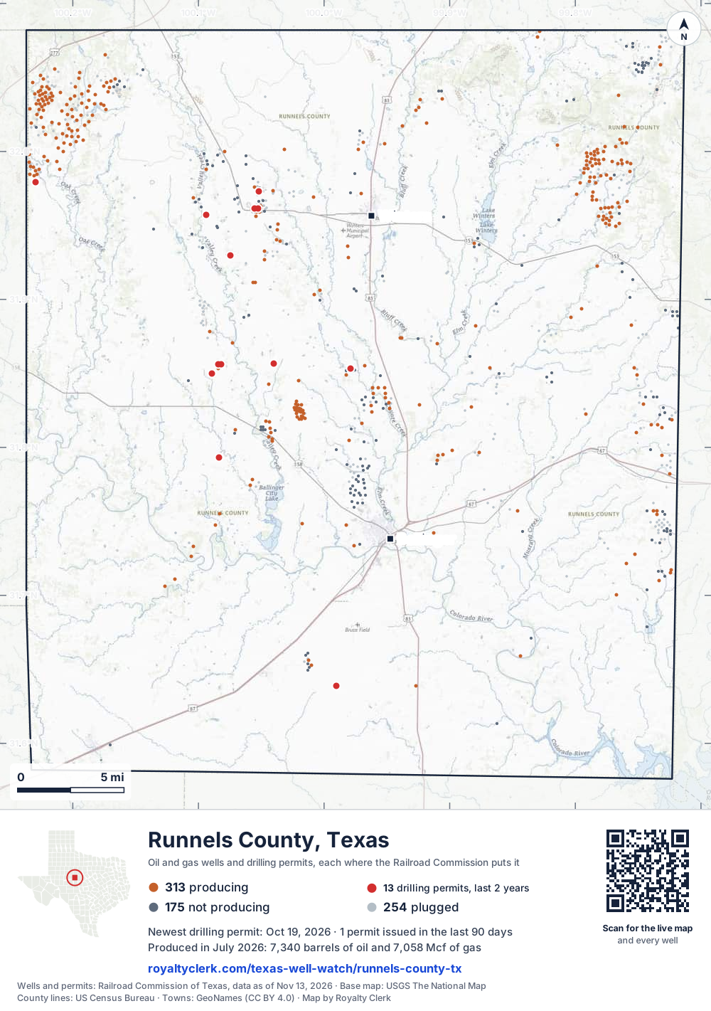
- Drilling locations12Permits issued in the last two years
- Producing wells313On a lease reporting production now
- Not producing175Shut in, inactive or no lease on record
- Plugged254The state's wellbore record says plugged
Sources: Railroad Commission of Texas well layers and permit files, US Census Bureau county outline, town points from GeoNames (CC BY 4.0), base map from USGS The National Map. A dot is a surface location; a horizontal well runs a mile or more from it.
742 wells with a location on the state's map and 12 drilling locations permitted in the last 24 months, each where the Railroad Commission puts it.
A permit is not a well.
Runnels County is one of the 61 counties of the Permian Basin
Wells near each town in Runnels County
Wells within 10 miles of each town, on either side of the county line.
Use this map on your site
You may show this map on any site, unchanged. Keep the credit line and its link to Royalty Clerk under the map. The picture updates by itself as the state records new wells and permits.
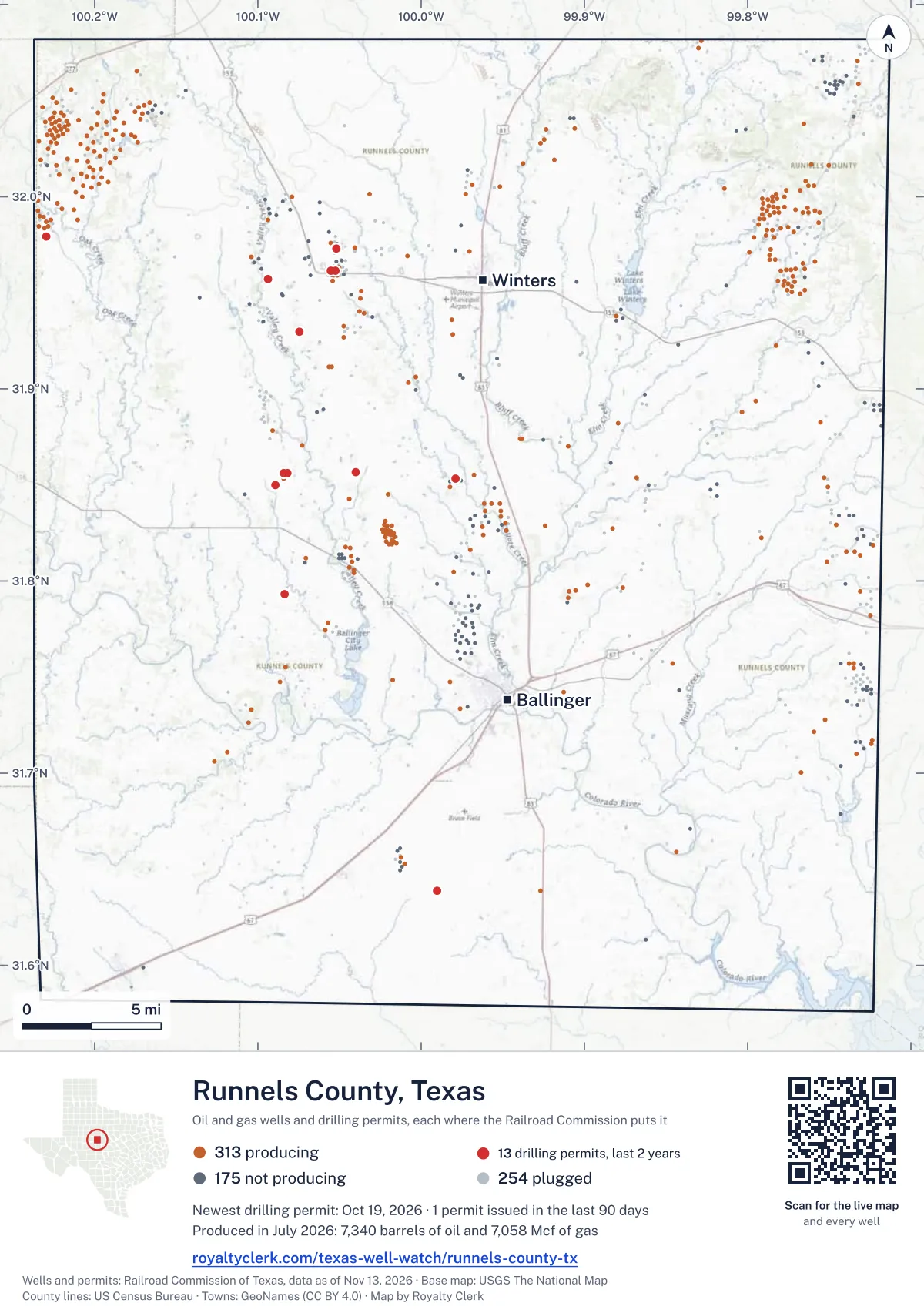
<a href="https://royaltyclerk.com/texas-well-watch/runnels-county-tx"><img src="https://royaltyclerk.com/maps/county-wells/runnels-county-tx.svg" alt="Map of Runnels County, Texas, with 742 oil and gas wells and 12 recent drilling locations as dots." width="1000" height="1421" loading="lazy" style="max-width:100%;height:auto;border:0"></a>
<p style="margin:4px 0 0;font-size:14px">Map: <a href="https://royaltyclerk.com/texas-well-watch/runnels-county-tx">Runnels County, Texas oil and gas wells</a> by Royalty Clerk, from Railroad Commission of Texas records</p>
The last twelve months
Month by month in Runnels County
| Month | Permits | Completions | First production |
|---|---|---|---|
| Oct 2026 | 1 | 0 | 0 |
| Aug 2026 | 2 | 0 | 0 |
| May 2026 | 1 | 0 | 0 |
| Mar 2026 | 0 | 1 | 0 |
| Jan 2026 | 1 | 0 | 0 |
Counted from November 21, 2025 to October 19, 2026, so the first and last months are partial. Source: Railroad Commission of Texas data sets.
Free, no sign-in
The newest drilling permits in Runnels County
| Issued | Lease and well | Operator | Drilling began | Depth, ft | API number | Coordinates | Permit |
|---|---|---|---|---|---|---|---|
| 2026-10-19 | HIRT 1recompletion · verticalMission Energy Inc.API 42-399-34947 · permit 091926831.85348, -99.978884,280 ft | Mission Energy Inc. | |||||
| 2026-08-12 | EVANS 3Anew drill · verticalNodding Donkey Resources LLCAPI 42-399-35634 · permit 091772231.85629, -100.08171drilling began 2026-08-14 · 5,000 ft | Nodding Donkey Resources LLC | |||||
| 2026-08-06 | RICHARD 1re-entry · verticalCedar Oil CompanyAPI 42-399-35323 · permit 091760731.97285, -100.051794,512 ft | Cedar Oil Company | |||||
| 2026-05-19 | SE-196 1new drill · verticalEnterprise Products OperatingllcAPI 42-399-35633 · permit 091565531.63868, -99.99008400 ft | Enterprise Products Operatingllc | |||||
| 2026-01-26 | FORMAN 1re-entry · verticalQuail Well Service, Inc.API 42-399-03066 · permit 091305131.97913, -100.229505,000 ft | Quail Well Service, Inc. | |||||
| 2025-10-29 | FENNELL 605re-entry · verticalCedar Oil CompanyAPI 42-399-03682 · permit 091144931.96141, -100.052724,808 ft | Cedar Oil Company | |||||
| 2025-10-24 | FENNELL 610re-entry · verticalCedar Oil CompanyAPI 42-399-03687 · permit 091131331.96136, -100.055184,413 ft | Cedar Oil Company | |||||
| 2025-08-06 | CATHODIC PROTECTION 28new drill · verticalEnergy Transfer CompanyAPI 42-399-35632 · permit 090948231.85668, -100.03984400 ft | Energy Transfer Company | |||||
| 2025-07-10 | MOCHA UNIT 1recompletion · verticalPony Express Corporate TrustAPI 42-399-35458 · permit 090913631.85006, -100.089204,740 ft | Pony Express Corporate Trust | |||||
| 2025-06-23 | CARL 1new drill · verticalEnrich Oil CorporationAPI 42-399-35631 · permit 090875431.92964, -100.074505,000 ft | Enrich Oil Corporation | |||||
| 2025-02-28 | CHASE 1new drill · verticalEnrich Oil CorporationAPI 42-399-35630 · permit 090626931.95699, -100.09385drilling began 2025-03-30 · 5,000 ft | Enrich Oil Corporation | |||||
| 2024-12-17 | RISE BULLSEYE 1new drill · verticalHarvest Petroleum Inc.API 42-399-35629 · permit 090472431.79297, -100.083765,000 ft | Harvest Petroleum Inc. | |||||
| 2024-11-18 | EVANS 3LKnew drill · verticalPony Express Corporate TrustAPI 42-399-35628 · permit 090383531.85632, -100.08434drilling began 2025-01-04 · 4,500 ft | Pony Express Corporate Trust | |||||
| 2024-11-08 | SNELSON 6reclass · verticalKoko Skadi, LLCAPI 42-399-34670 · permit 090383231.82664, -99.730133,042 ft | Koko Skadi, LLC | |||||
| 2024-11-08 | SNELSON 5reclass · verticalKoko Skadi, LLCAPI 42-399-34647 · permit 090383131.82333, -99.729104,450 ft | Koko Skadi, LLC | |||||
| 2024-11-08 | SNELSON 4reclass · verticalKoko Skadi, LLCAPI 42-399-34637 · permit 090382431.82222, -99.732693,250 ft | Koko Skadi, LLC | |||||
| 2024-08-26 | SE-189 1new drill · verticalEnterprise Products Texas Op LLCAPI 42-399-35627 · permit 090177831.67754, -100.09233400 ft | Enterprise Products Texas Op LLC | |||||
| 2024-08-09 | SE-192 1new drill · verticalEnterprise Products Texas Op LLCAPI 42-399-35626 · permit 090176831.66106, -100.04939400 ft | Enterprise Products Texas Op LLC | |||||
| 2024-07-25 | PENDERGRASS 2re-entry · verticalMcDonald Energy, Inc.API 42-399-30453 · permit 090142432.02232, -100.045145,000 ft | McDonald Energy, Inc. | |||||
| 2024-04-04 | PENDERGRASS 1new drill · verticalMcDonald Energy, Inc.API 42-399-35603 · permit 089848732.02077, -100.043855,000 ft | McDonald Energy, Inc. | |||||
| 2024-03-22 | FORT CHADBOURNE ODOM LIME UNIT 702recompletion · verticalL.c.s. Production CompanyAPI 42-399-35597 · permit 089821132.06555, -100.174385,700 ft | L.c.s. Production Company | |||||
| 2024-02-20 | ERNST 1new drill · verticalEnrich Oil CorporationAPI 42-399-35625 · permit 089734031.95403, -100.04349drilling began 2024-03-14 · 5,000 ft | Enrich Oil Corporation | |||||
| 2023-12-18 | HARRELL 1new drill · verticalDallas Petroleum Group, LLCAPI 42-399-35624 · permit 089599131.82896, -100.10359drilling began 2024-01-17 · 4,600 ft | Dallas Petroleum Group, LLC | |||||
| 2023-09-14 | JENNI 1new drill · verticalByrne Oil CompanyAPI 42-399-35623 · permit 089360231.95907, -100.05490drilling began 2023-09-29 · 5,000 ft | Byrne Oil Company | |||||
| 2023-09-01 | FENNELL 614re-entry · verticalCedar Oil CompanyAPI 42-399-34551 · permit 089329031.96244, -100.051434,750 ft | Cedar Oil Company |
A permit is permission to drill, not a well. Source: Railroad Commission of Texas drilling permit files.
Year by year
Drilling permits issued in Runnels County, by year
| Year | Permits issued |
|---|---|
| 2026 so far | 5 |
| 2025 | 6 |
| 2024 | 11 |
| 2023 | 3 |
Counted from the permit files we hold, which start in 2023; that first year may be partial. Source: Railroad Commission of Texas drilling permit files.
The latest
The most recent records
| Date | What, who and where |
|---|---|
| 2026-10-19 | Permit issued: Mission Energy Inc.HIRT · A-1258 · permit 0919268 |
| 2026-08-12 | Permit issued: Nodding Donkey Resources LLCEVANS · A-755 · permit 0917722 |
| 2026-08-06 | Permit issued: Cedar Oil CompanyRICHARD · A-690 · permit 0917607 |
| 2026-05-19 | Permit issued: Enterprise Products OperatingllcSE-196 · A-507 · permit 0915655 |
| 2026-03-09 | CompletedA-345 |
| 2026-01-26 | Permit issued: Quail Well Service, Inc.FORMAN · A-872 · permit 0913051 |
Follow it
Watch Runnels County, or one abstract
What do you want to follow?
Where the land is. Your deed or lease names it.
For example A-1119, or Bush, or T&P 38. Your deed or the tax bill has it.
Other counties
Drilling activity in other counties
Related
Related
- ToolTexas well watchPermit, completion, first production and when the first check is due.
- ToolIs this buyout offer fair?The offer as months of your income, what the acres mean, and the questions to ask.
- ToolIs this lease offer good?Bonus and royalty against the county, and a scan of the lease's clauses.
- Texas dataTexas operator changesWho took over whose leases in the last 24 months.
- ToolLate payment interestDeadlines and the interest a late payment earns.
- Texas dataTexas oil and gas atlas254 counties, every lease, operator and field.
FAQ
Questions people ask
How many wells were permitted in Runnels County in the last year?
The Railroad Commission issued 5 drilling permits in Runnels County in the twelve months to October 19, 2026, and recorded 1 completion and 0 first-production reports. A permit is permission to drill, not a well.
How do I get an alert when a permit is issued near my land in Runnels County?
Choose your abstract on this page, or the whole county, and sign in. You get one email a week, only when something new is recorded after you sign up. The alert says whether an event is on an interest in your Mineral File, on a place you follow, or only nearby.
When is my first royalty check due after a new well?
Natural Resources Code section 91.402(a) says on or before 120 days after the end of the month of first sale of production from the well. The state's first-production month is the closest public marker, so the date on this page is the earliest, not a certainty.
Got a new well on your land?
The first check is due within 120 days after the end of the month of first sale.
Sources
Primary sources, opened on 29 September 2026. Statute text is the current version on statutes.capitol.texas.gov.