
Smith County, Texas
Smith County drilling permits: what the state recorded
- 15drilling permits
- 21completions
- 5first-production reports
- in the last twelve months
Wells by coordinates
Oil wells and drilling locations in Smith County
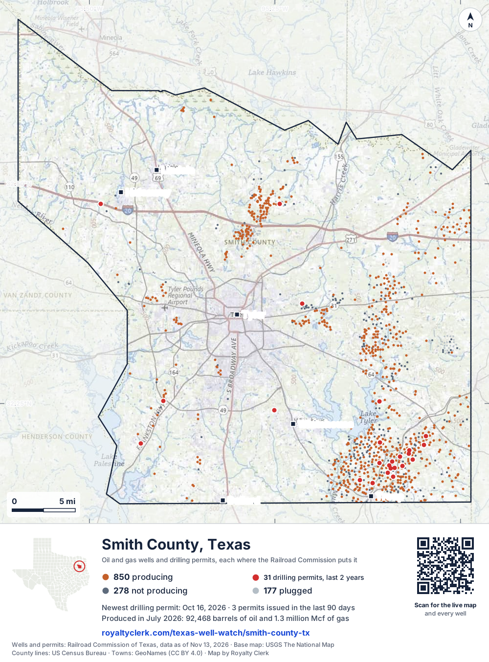
- Drilling locations31Permits issued in the last two years
- Producing wells850On a lease reporting production now
- Not producing278Shut in, inactive or no lease on record
- Plugged177The state's wellbore record says plugged
Sources: Railroad Commission of Texas well layers and permit files, US Census Bureau county outline, town points from GeoNames (CC BY 4.0), base map from USGS The National Map. A dot is a surface location; a horizontal well runs a mile or more from it.
1,305 wells with a location on the state's map and 31 drilling locations permitted in the last 24 months, each where the Railroad Commission puts it.
A permit is not a well.
Wells near each town in Smith County
Wells within 10 miles of each town, on either side of the county line.
Use this map on your site
You may show this map on any site, unchanged. Keep the credit line and its link to Royalty Clerk under the map. The picture updates by itself as the state records new wells and permits.
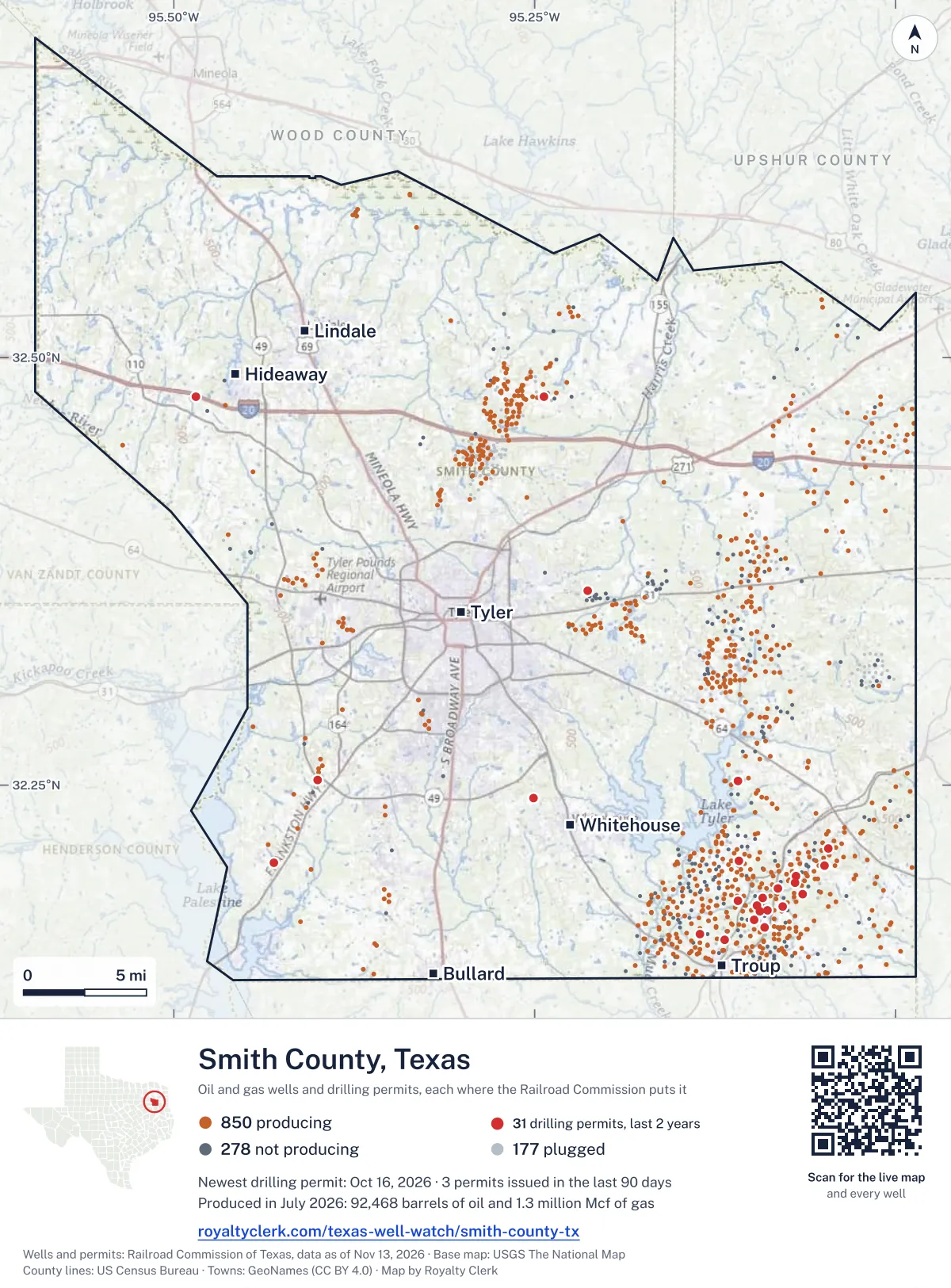
<a href="https://royaltyclerk.com/texas-well-watch/smith-county-tx"><img src="https://royaltyclerk.com/maps/county-wells/smith-county-tx.svg" alt="Map of Smith County, Texas, with 1,305 oil and gas wells and 31 recent drilling locations as dots." width="1000" height="1354" loading="lazy" style="max-width:100%;height:auto;border:0"></a>
<p style="margin:4px 0 0;font-size:14px">Map: <a href="https://royaltyclerk.com/texas-well-watch/smith-county-tx">Smith County, Texas oil and gas wells</a> by Royalty Clerk, from Railroad Commission of Texas records</p>
The last twelve months
Month by month in Smith County
| Month | Permits | Completions | First production |
|---|---|---|---|
| Oct 2026 | 3 | 1 | 0 |
| Sep 2026 | 0 | 2 | 0 |
| Aug 2026 | 1 | 1 | 0 |
| Jul 2026 | 1 | 2 | 0 |
| Jun 2026 | 1 | 3 | 0 |
| May 2026 | 0 | 1 | 0 |
| Apr 2026 | 0 | 0 | 1 |
| Mar 2026 | 0 | 8 | 2 |
| Feb 2026 | 4 | 1 | 0 |
| Jan 2026 | 4 | 2 | 2 |
| Nov 2025 | 1 | 0 | 0 |
Counted from November 16, 2025 to October 16, 2026, so the first and last months are partial. Source: Railroad Commission of Texas data sets.
Free, no sign-in
The newest drilling permits in Smith County
| Issued | Lease and well | Operator | Drilling began | Depth, ft | API number | Coordinates | Permit |
|---|---|---|---|---|---|---|---|
| 2026-10-16 | WALDROP 4 1recompletion · verticalFaulconer Energy, LLCAPI 42-423-31854 · permit 091930832.15975, -95.1180812,150 ft | Faulconer Energy, LLC | |||||
| 2026-10-16 | MILTON ANDERSON 9 1recompletion · verticalFaulconer Energy, LLCAPI 42-423-31800 · permit 091929532.18970, -95.0814511,716 ft | Faulconer Energy, LLC | |||||
| 2026-10-08 | OVERTON 302 1recompletion · verticalFaulconer Energy, LLCAPI 42-423-30987 · permit 091893632.21317, -95.0465412,700 ft | Faulconer Energy, LLC | |||||
| 2026-08-06 | ALLRED 1 1recompletion · verticalFaulconer Energy, LLCAPI 42-423-30575 · permit 091750032.20594, -95.1085612,000 ft | Faulconer Energy, LLC | |||||
| 2026-07-10 | WILSON VERNON 6 1recompletion · verticalFaulconer Energy, LLCAPI 42-423-31680 · permit 091714132.18216, -95.1089711,912 ft | Faulconer Energy, LLC | |||||
| 2026-06-02 | KICKAPOO CREEK GAS UNIT 6recompletion · verticalFaulconer Energy, LLCAPI 42-423-31648 · permit 091549632.18403, -95.0922811,770 ft | Faulconer Energy, LLC | |||||
| 2026-02-20 | SALLIE WARREN B CV (AW) 2Hnew drill · horizontalSabine Energy Inc.API 42-423-32481 · permit 091255032.16289, -95.13576drilling began 2026-04-09 · 13,000 ft | Sabine Energy Inc. | |||||
| 2026-02-18 | CP #26-03 CATHODIC PROTECTION 36new drill · verticalAtmos Pipeline - TexasAPI 42-423-32486 · permit 091316732.24232, -95.25106470 ft | Atmos Pipeline - Texas | |||||
| 2026-02-12 | THEDFORD 2Hnew drill · horizontalValence Operating CompanyAPI 42-423-32485 · permit 091339232.25303, -95.400659,300 ft | Valence Operating Company | |||||
| 2026-02-02 | WOOLF 2 1recompletion · verticalFaulconer Energy, LLCAPI 42-423-31542 · permit 091315432.19304, -95.069738,460 ft | Faulconer Energy, LLC | |||||
| 2026-01-30 | LUSCOMBE B (ALLOC) 9Hnew drill · horizontalValence Operating CompanyAPI 42-423-32484 · permit 091314632.25310, -95.4006612,600 ft | Valence Operating Company | |||||
| 2026-01-26 | SALLIE WARREN B OU 2Hnew drill · horizontalSabine Energy Inc.API 42-423-32483 · permit 091286932.16278, -95.135769,300 ft | Sabine Energy Inc. | |||||
| 2026-01-20 | SALLIE WARREN A OU 1Hnew drill · horizontalSabine Energy Inc.API 42-423-32482 · permit 091285032.16294, -95.13576drilling began 2026-04-17 · 9,300 ft | Sabine Energy Inc. | |||||
| 2026-01-12 | MCCRARY 1Hnew drill · horizontalValence Operating CompanyAPI 42-423-32480 · permit 091249532.25317, -95.40067drilling began 2026-02-01 · 9,500 ft | Valence Operating Company | |||||
| 2025-11-25 | SALLIE WARREN A CV (AW) 1Hnew drill · horizontalSabine Energy Inc.API 42-423-32479 · permit 091188232.16283, -95.13575drilling began 2026-04-18 · 12,000 ft | Sabine Energy Inc. | |||||
| 2025-10-16 | BRIGHT 3 1recompletion · verticalFaulconer Energy, LLCAPI 42-423-31610 · permit 091112732.16697, -95.0909811,862 ft | Faulconer Energy, LLC | |||||
| 2025-09-02 | KNOX HEIRS UNIT 1new drill · verticalStroud Petroleum, Inc.API 42-423-32478 · permit 091015532.47702, -95.48463drilling began 2025-12-04 · 7,800 ft | Stroud Petroleum, Inc. | |||||
| 2025-08-15 | KICKAPOO TP 12 1recompletion · verticalFaulconer Energy, LLCAPI 42-423-32041 · permit 090982432.17647, -95.09391drilling began 2006-12-25 · 8,880 ft | Faulconer Energy, LLC | |||||
| 2025-08-14 | JACKSON TP 11 1recompletion · verticalFaulconer Energy, LLCAPI 42-423-32022 · permit 090982132.18652, -95.064218,730 ft | Faulconer Energy, LLC | |||||
| 2025-07-14 | ANDERSON 'TP' 13 1recompletion · verticalFaulconer Energy, LLCAPI 42-423-31776 · permit 090916932.17903, -95.07839drilling began 2004-06-18 · 8,580 ft | Faulconer Energy, LLC | |||||
| 2025-05-13 | STEWART B (AW) 2Hnew drill · horizontalSabine Oil & Gas CorporationAPI 42-423-32477 · permit 090709832.25248, -95.10906drilling began 2025-07-30 · 12,300 ft | Sabine Oil & Gas Corporation | |||||
| 2025-04-11 | KICKAPOO TP 8 1recompletion · verticalFaulconer Energy, LLCAPI 42-423-31736 · permit 090729632.17963, -95.096318,730 ft | Faulconer Energy, LLC | |||||
| 2025-04-07 | KICKAPOO 'TP' 4 1recompletion · verticalFaulconer Energy, LLCAPI 42-423-31575 · permit 090715032.17135, -95.097748,805 ft | Faulconer Energy, LLC | |||||
| 2025-03-28 | KICKAPOO CREEK GAS UNIT 5recompletion · verticalSouthwest Operating, Inc.-TylerAPI 42-423-31708 · permit 090694532.17656, -95.08845drilling began 2003-02-20 · 11,886 ft | Southwest Operating, Inc.-Tyler | |||||
| 2025-03-07 | STEWART A (AW) 1Hnew drill · horizontalSabine Oil & Gas CorporationAPI 42-423-32476 · permit 090577832.25252, -95.10910drilling began 2025-07-11 · 12,500 ft | Sabine Oil & Gas Corporation | |||||
| 2025-02-19 | WOOLF 'TP' 3recompletion · verticalFaulconer Energy, LLCAPI 42-423-31573 · permit 090531532.19680, -95.0692211,720 ft | Faulconer Energy, LLC | |||||
| 2025-02-06 | FENDER 1new drill · verticalTexakoma E & P, LLCAPI 42-423-32475 · permit 090571332.47714, -95.24330drilling began 2025-03-07 · 10,500 ft | Texakoma E & P, LLC | |||||
| 2025-01-31 | LOTUS (ALLOC) 1Hnew drill · horizontalValence Operating CompanyAPI 42-423-32474 · permit 090546932.20448, -95.430389,600 ft | Valence Operating Company | |||||
| 2025-01-23 | LILY (ALLOC) 1Hnew drill · horizontalValence Operating CompanyAPI 42-423-32473 · permit 090506732.20448, -95.430489,500 ft | Valence Operating Company | |||||
| 2024-12-31 | JONES 'A' 1re-entry · vertical3-T Exploration, Inc.API 42-423-31624 · permit 090488232.36347, -95.213351,220 ft | 3-T Exploration, Inc. | |||||
| 2024-12-20 | WRIGHT 'TP' 6recompletion · verticalFaulconer Energy, LLCAPI 42-423-31741 · permit 090439932.20315, -95.0489711,788 ft | Faulconer Energy, LLC | |||||
| 2024-10-31 | WALDROP 'TP' 4recompletion · verticalFaulconer Energy, LLCAPI 42-423-31854 · permit 090362732.15975, -95.11808drilling began 2024-12-18 · 12,150 ft | Faulconer Energy, LLC | |||||
| 2024-10-25 | HOPPER 1new drill · verticalStrand Energy, L.c.API 42-423-32471 · permit 090353832.38936, -95.462509,900 ft | Strand Energy, L.c. | |||||
| 2024-10-18 | DARE UNIT 1Hnew drill · horizontalGeosouthern Operating II, LLCAPI 42-423-32470 · permit 090282132.37391, -95.465029,500 ft | Geosouthern Operating II, LLC | |||||
| 2024-07-10 | ODOM 'TP' 15 15recompletion · verticalFaulconer Energy, LLCAPI 42-423-32179 · permit 090102632.14140, -95.13824drilling began 2023-11-27 · 12,380 ft | Faulconer Energy, LLC | |||||
| 2024-06-12 | KIRKPATRICK 5 TP 5recompletion · verticalFaulconer Energy, LLCAPI 42-423-32105 · permit 090035532.15181, -95.1222912,302 ft | Faulconer Energy, LLC | |||||
| 2024-06-12 | ARNOLD 'TP' 1 6recompletion · verticalFaulconer Energy, LLCAPI 42-423-31646 · permit 090034932.19392, -95.0741411,879 ft | Faulconer Energy, LLC | |||||
| 2024-05-14 | SAND FLAT UNIT 52recompletion · verticalVess Oil CorporationAPI 42-423-30198 · permit 089969432.47061, -95.26092drilling began 1977-06-02 · 9,545 ft | Vess Oil Corporation | |||||
| 2024-04-05 | COX UNIT 1new drill · vertical3-T Exploration, Inc.API 42-423-32469 · permit 089722932.22383, -95.36344drilling began 2024-04-15 · 7,850 ft | 3-T Exploration, Inc. | |||||
| 2024-03-25 | ODOM 'TP' 2 2recompletion · verticalFaulconer Energy, LLCAPI 42-423-31773 · permit 089831832.14583, -95.1531312,226 ft | Faulconer Energy, LLC | |||||
| 2023-12-27 | AFG 2new drill · verticalMaximus Operating, Ltd.API 42-423-32468 · permit 089596032.56090, -95.40875drilling began 2024-02-07 · 9,000 ft | Maximus Operating, Ltd. | |||||
| 2023-12-19 | SHAW (PETTIT) 5recompletion · verticalFaulconer Energy, LLCAPI 42-423-31756 · permit 089599932.18348, -95.15681drilling began 2024-03-27 · 11,910 ft | Faulconer Energy, LLC | |||||
| 2023-12-13 | MCMOYLE 4recompletion · verticalEagle Oil & Gas Co.API 42-423-31866 · permit 089568332.15840, -95.1661912,300 ft | Eagle Oil & Gas Co. | |||||
| 2023-12-11 | LYLES 7recompletion · verticalEagle Oil & Gas Co.API 42-423-32007 · permit 089568232.20394, -95.1410312,000 ft | Eagle Oil & Gas Co. | |||||
| 2023-12-08 | KLEUPPEL GAS UNIT 3recompletion · verticalEagle Oil & Gas Co.API 42-423-31831 · permit 089568132.20528, -95.1511312,100 ft | Eagle Oil & Gas Co. | |||||
| 2023-11-13 | WEST TYLER (PALUXY BANKHEAD) 6Anew drill · verticalWeathers Exploration, Inc.API 42-423-32467 · permit 089496332.38525, -95.40118drilling began 2023-12-08 · 8,200 ft | Weathers Exploration, Inc. | |||||
| 2023-11-09 | WALDROP 'TP' 8recompletion · verticalFaulconer Energy, LLCAPI 42-423-31998 · permit 089509732.15371, -95.11918drilling began 2024-02-05 · 12,150 ft | Faulconer Energy, LLC | |||||
| 2023-10-23 | NEWTON, W F (ST02) 1Xrecompletion · verticalMaximus Operating, Ltd.API 42-423-31345 · permit 089471932.40509, -95.442708,999 ft | Maximus Operating, Ltd. | |||||
| 2023-01-19 | ANTONY 1Hnew drill · horizontalValence Operating CompanyAPI 42-423-32465 · permit 088731332.29442, -95.38323drilling began 2023-04-17 · 8,800 ft | Valence Operating Company |
A permit is permission to drill, not a well. Source: Railroad Commission of Texas drilling permit files.
Year by year
Drilling permits issued in Smith County, by year
| Year | Permits issued |
|---|---|
| 2026 so far | 14 |
| 2025 | 15 |
| 2024 | 11 |
| 2023 | 9 |
Counted from the permit files we hold, which start in 2023; that first year may be partial. Source: Railroad Commission of Texas drilling permit files.
The latest
The most recent records
| Date | What, who and where |
|---|---|
| 2026-10-16 | Permit issued: Faulconer Energy, LLCWALDROP 4 · A-714 · permit 0919308 |
| 2026-10-16 | Permit issued: Faulconer Energy, LLCMILTON ANDERSON 9 · A-11 · permit 0919295 |
| 2026-10-08 | Permit issued: Faulconer Energy, LLCOVERTON 302 · A-12 · permit 0918936 |
| 2026-10-07 | Completed: Valence Operating CompanyANTONY · A-18 · permit 0887313 |
| 2026-09-24 | Completed: Valence Operating CompanyLOTUS (ALLOC) · A-18 · permit 0905469 |
| 2026-09-20 | Completed: Valence Operating CompanyLILY (ALLOC) · A-18 · permit 0905067 |
| 2026-08-25 | Completed: Valence Operating CompanyLUSCOMBE B (ALLOC) · A-18 · permit 0913146 |
| 2026-08-06 | Permit issued: Faulconer Energy, LLCALLRED 1 · A-13 · permit 0917500 |
| 2026-07-20 | Completed: Faulconer Energy, LLCWILSON VERNON 6 · A-13 · permit 0917141 |
| 2026-07-18 | Completed: Valence Operating CompanyTHEDFORD · A-18 |
| 2026-07-10 | Permit issued: Faulconer Energy, LLCWILSON VERNON 6 · A-13 · permit 0917141 |
| 2026-06-19 | Completed: Valence Operating CompanyMCCRARY · A-18 · permit 0912495 |
| 2026-06-18 | Completed: Valence Operating CompanySHAMBURGER LAKE UNIT · A-557 |
| 2026-06-11 | Completed: Valence Operating CompanyLUSCOMBE, KATHERINE GAS UNIT · A-18 |
| 2026-06-02 | Permit issued: Faulconer Energy, LLCKICKAPOO CREEK GAS UNIT · A-13 · permit 0915496 |
Coming up
First checks coming due in Smith County
- THEDFORD, Valence Operating Companyby November 28, 2026
- WILSON VERNON 6, Faulconer Energy, LLCby November 28, 2026
Follow it
Watch Smith County, or one abstract
What do you want to follow?
Where the land is. Your deed or lease names it.
For example A-1119, or Bush, or T&P 38. Your deed or the tax bill has it.
Other counties
Drilling activity in other counties
Related
Related
- ToolTexas well watchPermit, completion, first production and when the first check is due.
- ToolIs this buyout offer fair?The offer as months of your income, what the acres mean, and the questions to ask.
- ToolIs this lease offer good?Bonus and royalty against the county, and a scan of the lease's clauses.
- Texas dataTexas operator changesWho took over whose leases in the last 24 months.
- ToolLate payment interestDeadlines and the interest a late payment earns.
- Texas dataTexas oil and gas atlas254 counties, every lease, operator and field.
FAQ
Questions people ask
How many wells were permitted in Smith County in the last year?
The Railroad Commission issued 15 drilling permits in Smith County in the twelve months to October 16, 2026, and recorded 21 completions and 5 first-production reports. A permit is permission to drill, not a well.
How do I get an alert when a permit is issued near my land in Smith County?
Choose your abstract on this page, or the whole county, and sign in. You get one email a week, only when something new is recorded after you sign up. The alert says whether an event is on an interest in your Mineral File, on a place you follow, or only nearby.
When is my first royalty check due after a new well?
Natural Resources Code section 91.402(a) says on or before 120 days after the end of the month of first sale of production from the well. The state's first-production month is the closest public marker, so the date on this page is the earliest, not a certainty.
Got a new well on your land?
The first check is due within 120 days after the end of the month of first sale.
Sources
Primary sources, opened on 29 September 2026. Statute text is the current version on statutes.capitol.texas.gov.