
Stonewall County, Texas
Stonewall County drilling permits: what the state recorded
- 7drilling permits
- 4completions
- 0first-production reports
- in the last twelve months
Wells by coordinates
Oil wells and drilling locations in Stonewall County
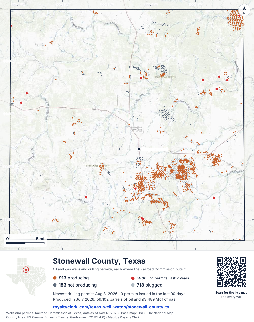
- Drilling locations14Permits issued in the last two years
- Producing wells913On a lease reporting production now
- Not producing183Shut in, inactive or no lease on record
- Plugged713The state's wellbore record says plugged
Sources: Railroad Commission of Texas well layers and permit files, US Census Bureau county outline, town points from GeoNames (CC BY 4.0), base map from USGS The National Map. A dot is a surface location; a horizontal well runs a mile or more from it.
1,809 wells with a location on the state's map and 14 drilling locations permitted in the last 24 months, each where the Railroad Commission puts it.
A permit is not a well.
Stonewall County is one of the 61 counties of the Permian Basin
Wells near each town in Stonewall County
Wells within 10 miles of each town, on either side of the county line.
Use this map on your site
You may show this map on any site, unchanged. Keep the credit line and its link to Royalty Clerk under the map. The picture updates by itself as the state records new wells and permits.
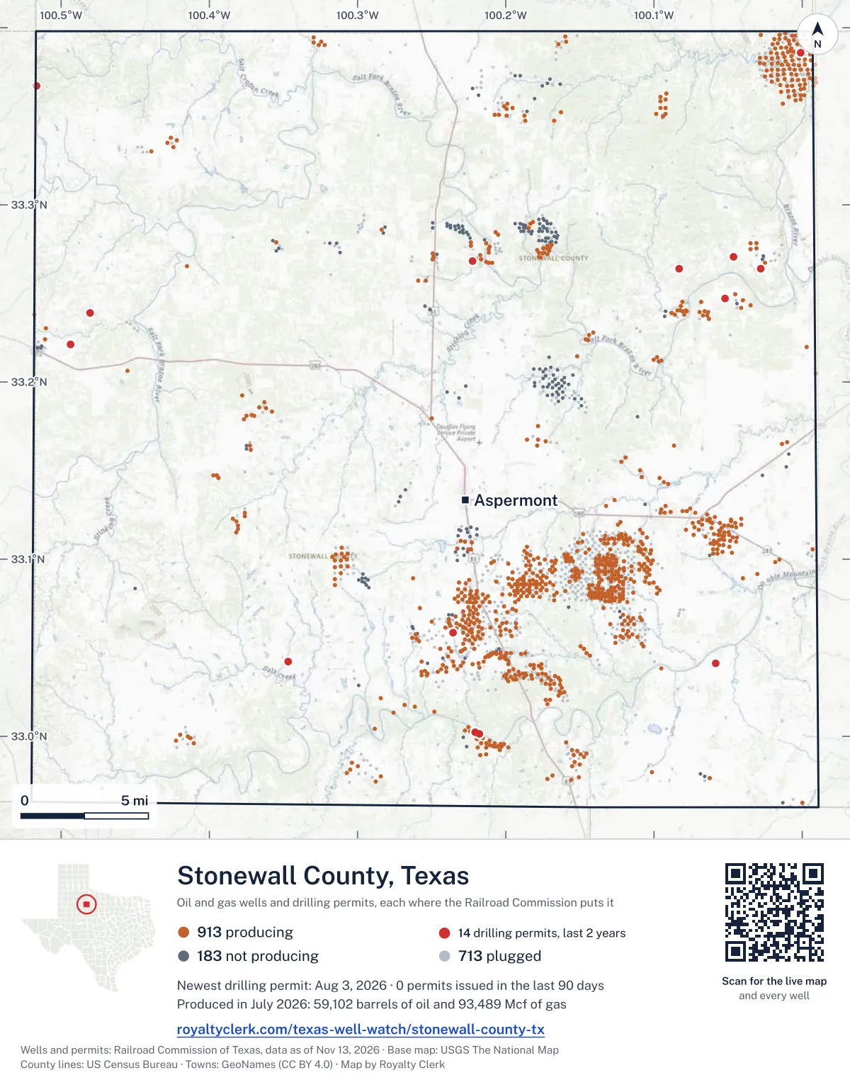
<a href="https://royaltyclerk.com/texas-well-watch/stonewall-county-tx"><img src="https://royaltyclerk.com/maps/county-wells/stonewall-county-tx.svg" alt="Map of Stonewall County, Texas, with 1,809 oil and gas wells and 14 recent drilling locations as dots." width="1000" height="1270" loading="lazy" style="max-width:100%;height:auto;border:0"></a>
<p style="margin:4px 0 0;font-size:14px">Map: <a href="https://royaltyclerk.com/texas-well-watch/stonewall-county-tx">Stonewall County, Texas oil and gas wells</a> by Royalty Clerk, from Railroad Commission of Texas records</p>
The last twelve months
Month by month in Stonewall County
| Month | Permits | Completions | First production |
|---|---|---|---|
| Aug 2026 | 1 | 0 | 0 |
| Jun 2026 | 0 | 1 | 0 |
| May 2026 | 1 | 0 | 0 |
| Apr 2026 | 0 | 1 | 0 |
| Mar 2026 | 1 | 0 | 0 |
| Feb 2026 | 2 | 1 | 0 |
| Jan 2026 | 1 | 0 | 0 |
| Dec 2025 | 1 | 1 | 0 |
Counted from November 19, 2025 to August 3, 2026, so the first and last months are partial. Source: Railroad Commission of Texas data sets.
Free, no sign-in
The newest drilling permits in Stonewall County
| Issued | Lease and well | Operator | Drilling began | Depth, ft | API number | Coordinates | Permit |
|---|---|---|---|---|---|---|---|
| 2026-08-03 | WOOD 1new drill · verticalPatton Exploration, Inc.API 42-433-34261 · permit 091752233.24707, -100.05215drilling began 2026-08-15 · 4,600 ft | Patton Exploration, Inc. | |||||
| 2026-05-08 | FERGUSON 135 1recompletion · verticalScout Energy Management LLCAPI 42-433-33500 · permit 091503433.00120, -100.217885,701 ft | Scout Energy Management LLC | |||||
| 2026-03-09 | HOT SPRINGS 4new drill · verticalSojourner Drilling CorporationAPI 42-433-34260 · permit 091392533.36702, -100.51649drilling began 2026-04-30 · 4,500 ft | Sojourner Drilling Corporation | |||||
| 2026-02-26 | ESPLMP90 1new drill · verticalKinder Morgan CO2 Company LLCAPI 42-433-34259 · permit 091330633.38596, -100.00109350 ft | Kinder Morgan CO2 Company LLC | |||||
| 2026-02-20 | MCMILLIN, I.S. AC 11 4Rre-entry · verticalL.c.s. Production CompanyAPI 42-433-30001 · permit 091354533.05834, -100.235853,077 ft | L.c.s. Production Company | |||||
| 2026-01-26 | SALT CREEK 1new drill · verticalChisholm Operating, Inc.API 42-433-34258 · permit 091307333.04239, -100.34660drilling began 2026-03-19 · 3,990 ft | Chisholm Operating, Inc. | |||||
| 2025-12-12 | BEAKLEY 1new drill · verticalBridwell Oil Co.API 42-433-34257 · permit 091211233.26384, -100.02819drilling began 2026-01-21 · 7,000 ft | Bridwell Oil Co. | |||||
| 2025-09-23 | FLAT TOP RANCH DMF 1new drill · verticalNBX Energy, LLCAPI 42-433-34256 · permit 091060833.04142, -100.05842drilling began 2025-09-28 · 6,500 ft | NBX Energy, LLC | |||||
| 2025-09-18 | GRAHAM 'A' 1new drill · verticalSalida Exploration, LLCAPI 42-433-34255 · permit 091052433.26846, -100.22247drilling began 2025-11-07 · 4,000 ft | Salida Exploration, LLC | |||||
| 2025-06-06 | MCFARLAND 1new drill · verticalPatton Exploration, Inc.API 42-433-34254 · permit 090841933.27067, -100.04608drilling began 2025-06-30 · 6,200 ft | Patton Exploration, Inc. | |||||
| 2025-06-04 | SELBY-HALL 1new drill · verticalHalliburton Operating CompanyAPI 42-433-34253 · permit 090840933.26400, -100.08281drilling began 2025-06-21 · 4,000 ft | Halliburton Operating Company | |||||
| 2025-04-25 | BRAZEE 2new drill · verticalTexas Royalty Corp.API 42-433-34252 · permit 090696833.23913, -100.48042drilling began 2025-06-04 · 3,800 ft | Texas Royalty Corp. | |||||
| 2025-02-13 | FERGUSON 135 2recompletion · verticalScout Energy Management LLCAPI 42-433-33690 · permit 090587733.00258, -100.220885,928 ft | Scout Energy Management LLC | |||||
| 2024-12-03 | KYLE 1new drill · verticalCanan Mowrey Operating, LLCAPI 42-433-34251 · permit 090431133.22122, -100.49340drilling began 2025-01-08 · 7,200 ft | Canan Mowrey Operating, LLC | |||||
| 2024-08-27 | BRAZEE 1new drill · verticalTexas Royalty Corp.API 42-433-34250 · permit 090228333.23850, -100.47790drilling began 2024-08-29 · 3,800 ft | Texas Royalty Corp. | |||||
| 2024-07-29 | BAUGH 2new drill · verticalCanan Mowrey Operating, LLCAPI 42-433-34249 · permit 090156633.20673, -99.99212drilling began 2024-08-12 · 7,200 ft | Canan Mowrey Operating, LLC | |||||
| 2024-06-28 | HOPE 1new drill · verticalVX Operating, LLCAPI 42-433-34248 · permit 090087833.19233, -100.37775drilling began 2024-07-21 · 4,000 ft | VX Operating, LLC | |||||
| 2024-04-24 | BISSETT '60' 2recompletion · verticalVertox LLCAPI 42-433-33610 · permit 089908133.35102, -100.207396,000 ft | Vertox LLC | |||||
| 2023-12-19 | FLOWERS 89 1new drill · verticalDallas Petroleum Group, LLCAPI 42-433-34247 · permit 089592533.09556, -100.18525drilling began 2023-12-23 · 6,800 ft | Dallas Petroleum Group, LLC | |||||
| 2023-10-10 | FERGUSON 15Erecompletion · verticalScout Energy Management LLCAPI 42-433-33759 · permit 087607232.99463, -100.208975,975 ft | Scout Energy Management LLC | |||||
| 2022-10-27 | GRAHAM 11new drill · verticalProduction Operators of TX, LLCAPI 42-433-34242 · permit 088521733.27704, -100.22340drilling began 2024-03-28 · 3,300 ft | Production Operators of TX, LLC |
A permit is permission to drill, not a well. Source: Railroad Commission of Texas drilling permit files.
Year by year
Drilling permits issued in Stonewall County, by year
| Year | Permits issued |
|---|---|
| 2026 so far | 6 |
| 2025 | 7 |
| 2024 | 5 |
| 2023 | 2 |
| 2022 | 1 |
Counted from the permit files we hold, which start in 2022; that first year may be partial. Source: Railroad Commission of Texas drilling permit files.
The latest
The most recent records
| Date | What, who and where |
|---|---|
| 2026-08-03 | Permit issued: Patton Exploration, Inc.WOOD · A-968 · permit 0917522 |
| 2026-06-10 | Completed: L.c.s. Production CompanyMCMILLIN (CANYON SAND) UNIT · A-896 |
| 2026-05-08 | Permit issued: Scout Energy Management LLCFERGUSON 135 · A-355 · permit 0915034 |
| 2026-04-29 | Completed: L.c.s. Production CompanyRIDDEL · A-1477 |
| 2026-03-09 | Permit issued: Sojourner Drilling CorporationHOT SPRINGS · A-385 · permit 0913925 |
| 2026-02-26 | Permit issued: Kinder Morgan CO2 Company LLCESPLMP90 · A-413 · permit 0913306 |
| 2026-02-20 | Permit issued: L.c.s. Production CompanyMCMILLIN, I.S. AC 11 · A-987 · permit 0913545 |
| 2026-02-18 | Completed: Citation Oil & Gas Corp.FLOWERS /CANYON SAND/ UNIT · A-1366 |
| 2026-01-26 | Permit issued: Chisholm Operating, Inc.SALT CREEK · A-367 · permit 0913073 |
| 2025-12-12 | Permit issued: Bridwell Oil Co.BEAKLEY · A-924 · permit 0912112 |
| 2025-12-12 | Completed: Scout Energy Management LLCFERGUSON 135 · A-355 · permit 0905877 |
Follow it
Watch Stonewall County, or one abstract
What do you want to follow?
Where the land is. Your deed or lease names it.
For example A-1119, or Bush, or T&P 38. Your deed or the tax bill has it.
Other counties
Drilling activity in other counties
Related
Related
- ToolTexas well watchPermit, completion, first production and when the first check is due.
- ToolIs this buyout offer fair?The offer as months of your income, what the acres mean, and the questions to ask.
- ToolIs this lease offer good?Bonus and royalty against the county, and a scan of the lease's clauses.
- Texas dataTexas operator changesWho took over whose leases in the last 24 months.
- ToolLate payment interestDeadlines and the interest a late payment earns.
- Texas dataTexas oil and gas atlas254 counties, every lease, operator and field.
FAQ
Questions people ask
How many wells were permitted in Stonewall County in the last year?
The Railroad Commission issued 7 drilling permits in Stonewall County in the twelve months to August 3, 2026, and recorded 4 completions and 0 first-production reports. A permit is permission to drill, not a well.
How do I get an alert when a permit is issued near my land in Stonewall County?
Choose your abstract on this page, or the whole county, and sign in. You get one email a week, only when something new is recorded after you sign up. The alert says whether an event is on an interest in your Mineral File, on a place you follow, or only nearby.
When is my first royalty check due after a new well?
Natural Resources Code section 91.402(a) says on or before 120 days after the end of the month of first sale of production from the well. The state's first-production month is the closest public marker, so the date on this page is the earliest, not a certainty.
Got a new well on your land?
The first check is due within 120 days after the end of the month of first sale.
Sources
Primary sources, opened on 29 September 2026. Statute text is the current version on statutes.capitol.texas.gov.