
Tarrant County, Texas
Tarrant County drilling permits: what the state recorded
- 27drilling permits
- 30completions
- 10first-production reports
- in the last twelve months
Wells by coordinates
Oil wells and drilling locations in Tarrant County
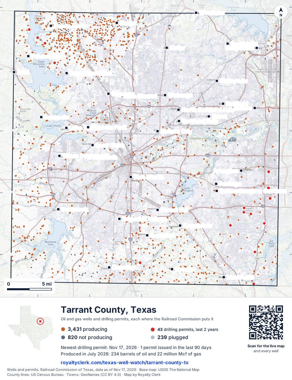
- Drilling locations42Permits issued in the last two years
- Producing wells3,431On a lease reporting production now
- Not producing821Shut in, inactive or no lease on record
- Plugged238The state's wellbore record says plugged
Sources: Railroad Commission of Texas well layers and permit files, US Census Bureau county outline, town points from GeoNames (CC BY 4.0), base map from USGS The National Map. A dot is a surface location; a horizontal well runs a mile or more from it.
4,490 wells with a location on the state's map and 42 drilling locations permitted in the last 24 months, each where the Railroad Commission puts it.
A permit is not a well.
Tarrant County is one of the 25 counties of the Barnett Shale
Wells near each town in Tarrant County
- Arlington1,074 wells
- Azle1,547 wells
- Bedford754 wells
- Benbrook1,729 wells
- Blue Mound1,725 wells
- Colleyville598 wells
- Crowley2,118 wells
- Dalworthington Gardens1,436 wells
- Eagle Mountain2,125 wells
- Edgecliff Village1,940 wells
- Euless573 wells
- Everman2,111 wells
- Forest Hill1,912 wells
- Fort Worth1,583 wells
- Grapevine278 wells
- Haltom City1,207 wells
- Haslet2,655 wells
- Hurst924 wells
- Keller1,345 wells
- Kennedale1,922 wells
- Lakeside1,459 wells
- Lake Worth1,501 wells
- Mansfield1,813 wells
- North Richland Hills1,033 wells
- Pantego1,396 wells
- Pecan Acres2,828 wells
- Pelican Bay1,875 wells
- Rendon2,315 wells
- Richland Hills1,020 wells
- River Oaks1,325 wells
- Saginaw1,843 wells
- Sansom Park1,492 wells
- Southlake444 wells
- Watauga1,231 wells
- Westlake1,025 wells
- Westworth1,363 wells
- White Settlement1,363 wells
Wells within 10 miles of each town, on either side of the county line.
Use this map on your site
You may show this map on any site, unchanged. Keep the credit line and its link to Royalty Clerk under the map. The picture updates by itself as the state records new wells and permits.
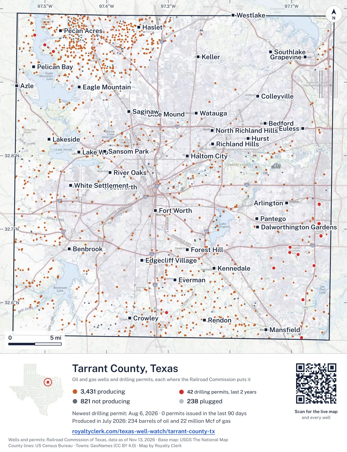
<a href="https://royaltyclerk.com/texas-well-watch/tarrant-county-tx"><img src="https://royaltyclerk.com/maps/county-wells/tarrant-county-tx.svg" alt="Map of Tarrant County, Texas, with 4,490 oil and gas wells and 42 recent drilling locations as dots." width="1000" height="1300" loading="lazy" style="max-width:100%;height:auto;border:0"></a>
<p style="margin:4px 0 0;font-size:14px">Map: <a href="https://royaltyclerk.com/texas-well-watch/tarrant-county-tx">Tarrant County, Texas oil and gas wells</a> by Royalty Clerk, from Railroad Commission of Texas records</p>
The last twelve months
Month by month in Tarrant County
| Month | Permits | Completions | First production |
|---|---|---|---|
| Sep 2026 | 0 | 1 | 0 |
| Aug 2026 | 1 | 3 | 0 |
| Jul 2026 | 0 | 2 | 0 |
| Jun 2026 | 1 | 9 | 10 |
| May 2026 | 0 | 4 | 0 |
| Apr 2026 | 4 | 5 | 0 |
| Mar 2026 | 0 | 3 | 0 |
| Feb 2026 | 6 | 0 | 0 |
| Jan 2026 | 3 | 1 | 0 |
| Dec 2025 | 4 | 0 | 0 |
| Nov 2025 | 8 | 2 | 0 |
Counted from November 15, 2025 to September 9, 2026, so the first and last months are partial. Source: Railroad Commission of Texas data sets.
Free, no sign-in
The newest drilling permits in Tarrant County
| Issued | Lease and well | Operator | Drilling began | Depth, ft | API number | Coordinates | Permit |
|---|---|---|---|---|---|---|---|
| 2026-08-06 | DIDO B 2 (AW) 2Hrecompletion · horizontalBKV North Texas, LLCAPI 42-439-30927 · permit 091747932.94176, -97.485968,500 ft | BKV North Texas, LLC | |||||
| 2026-06-25 | LEWISVILLE '7' UNIT 1Hrecompletion · horizontalBKV North Texas, LLCAPI 42-439-31434 · permit 091661232.58630, -97.302898,880 ft | BKV North Texas, LLC | |||||
| 2026-04-22 | ZION D MIPA UNIT 4Hnew drill · horizontalTep Barnett USA, LLCAPI 42-439-37394 · permit 091493432.65038, -97.063739,000 ft | Tep Barnett USA, LLC | |||||
| 2026-04-22 | ZION B MIPA UNIT 2Hnew drill · horizontalTep Barnett USA, LLCAPI 42-439-37393 · permit 091493332.65043, -97.063739,000 ft | Tep Barnett USA, LLC | |||||
| 2026-04-22 | ZION A MIPA UNIT 1Hnew drill · horizontalTep Barnett USA, LLCAPI 42-439-37392 · permit 091493232.65046, -97.063739,000 ft | Tep Barnett USA, LLC | |||||
| 2026-04-22 | ZION C MIPA UNIT 3Hnew drill · horizontalTep Barnett USA, LLCAPI 42-439-37391 · permit 091478032.65041, -97.063739,500 ft | Tep Barnett USA, LLC | |||||
| 2026-02-27 | TRADERS VILLAGE FISH CREEK MIPAC 3Hnew drill · horizontalTep Barnett USA, LLCAPI 42-439-37390 · permit 091371032.69077, -97.052199,000 ft | Tep Barnett USA, LLC | |||||
| 2026-02-27 | TRADERS VILLAGE FISH CREEK MIPAB 2Hnew drill · horizontalTep Barnett USA, LLCAPI 42-439-37389 · permit 091370832.69081, -97.052199,000 ft | Tep Barnett USA, LLC | |||||
| 2026-02-27 | TRADERS VILLAGE FISH CREEK MIPAA 1Hnew drill · horizontalTep Barnett USA, LLCAPI 42-439-37388 · permit 091370632.69085, -97.052199,000 ft | Tep Barnett USA, LLC | |||||
| 2026-02-18 | YU UNIT 4Hrecompletion · horizontalUpp Operating, LLCAPI 42-439-34820 · permit 091294532.64713, -97.128729,000 ft | Upp Operating, LLC | |||||
| 2026-02-12 | TRWD 'E' NORTH UNIT E 22Hrecompletion · horizontalBKV North Texas, LLCAPI 42-439-31264 · permit 091337932.95073, -97.50007drilling began 2005-09-10 · 10,216 ft | BKV North Texas, LLC | |||||
| 2026-02-12 | TRWD GANTT A UNIT 1Hrecompletion · horizontalBKV North Texas, LLCAPI 42-439-31842 · permit 091337132.96401, -97.51638drilling began 2007-07-04 · 9,835 ft | BKV North Texas, LLC | |||||
| 2026-01-09 | YU UNIT 7Hnew drill · horizontalUpp Operating, LLCAPI 42-439-37374 · permit 091163732.64724, -97.1287017,000 ft | Upp Operating, LLC | |||||
| 2026-01-09 | YU UNIT 5Hnew drill · horizontalUpp Operating, LLCAPI 42-439-37373 · permit 091158032.64719, -97.1287017,000 ft | Upp Operating, LLC | |||||
| 2026-01-07 | YU UNIT 6Hnew drill · horizontalUpp Operating, LLCAPI 42-439-37375 · permit 091158132.64721, -97.1287017,000 ft | Upp Operating, LLC | |||||
| 2025-12-01 | FLIGHT PATH 8Hnew drill · horizontalTep Barnett USA, LLCAPI 42-439-37387 · permit 091189232.67551, -97.102649,000 ft | Tep Barnett USA, LLC | |||||
| 2025-12-01 | FLIGHT PATH 7Hnew drill · horizontalTep Barnett USA, LLCAPI 42-439-37386 · permit 091187332.67559, -97.102649,000 ft | Tep Barnett USA, LLC | |||||
| 2025-12-01 | FLIGHT PATH 6Hnew drill · horizontalTep Barnett USA, LLCAPI 42-439-37385 · permit 091187232.67556, -97.102649,000 ft | Tep Barnett USA, LLC | |||||
| 2025-12-01 | FLIGHT PATH 5Hnew drill · horizontalTep Barnett USA, LLCAPI 42-439-37384 · permit 091187132.67553, -97.102649,000 ft | Tep Barnett USA, LLC | |||||
| 2025-11-24 | LANDING 7Hnew drill · horizontalTep Barnett USA, LLCAPI 42-439-37382 · permit 091186632.66837, -97.102799,000 ft | Tep Barnett USA, LLC | |||||
| 2025-11-24 | LANDING 6Hnew drill · horizontalTep Barnett USA, LLCAPI 42-439-37381 · permit 091186532.66838, -97.102849,000 ft | Tep Barnett USA, LLC | |||||
| 2025-11-24 | LANDING 5Hnew drill · horizontalTep Barnett USA, LLCAPI 42-439-37379 · permit 091186432.66838, -97.102899,000 ft | Tep Barnett USA, LLC | |||||
| 2025-11-24 | LANDING 4Hnew drill · horizontalTep Barnett USA, LLCAPI 42-439-37380 · permit 091186332.66838, -97.102949,000 ft | Tep Barnett USA, LLC | |||||
| 2025-11-24 | CLEAR SKIES 4Hnew drill · horizontalTep Barnett USA, LLCAPI 42-439-37383 · permit 091186232.67548, -97.102649,000 ft | Tep Barnett USA, LLC | |||||
| 2025-11-18 | DAY 4Hnew drill · horizontalTep Barnett USA, LLCAPI 42-439-37378 · permit 091177132.60382, -97.081569,000 ft | Tep Barnett USA, LLC | |||||
| 2025-11-18 | DAY 3Hnew drill · horizontalTep Barnett USA, LLCAPI 42-439-37377 · permit 091177032.60386, -97.081569,000 ft | Tep Barnett USA, LLC | |||||
| 2025-11-18 | DAY 2Hnew drill · horizontalTep Barnett USA, LLCAPI 42-439-37376 · permit 091176932.60390, -97.081579,000 ft | Tep Barnett USA, LLC | |||||
| 2025-09-18 | WESTERFELD MATHIS UNIT 1 6Hnew drill · horizontalTep Barnett USA, LLCAPI 42-439-37372 · permit 091022732.55248, -97.0837310,000 ft | Tep Barnett USA, LLC | |||||
| 2025-09-11 | WESTERFELD MATHIS UNIT 1 5Hnew drill · horizontalTep Barnett USA, LLCAPI 42-439-37371 · permit 091022632.55247, -97.0837610,000 ft | Tep Barnett USA, LLC | |||||
| 2025-09-11 | WESTERFELD MATHIS UNIT 1 4Hnew drill · horizontalTep Barnett USA, LLCAPI 42-439-37370 · permit 091022432.55245, -97.0837910,000 ft | Tep Barnett USA, LLC | |||||
| 2025-09-10 | WESTERFELD MATHIS UNIT 1 3Hnew drill · horizontalTep Barnett USA, LLCAPI 42-439-37369 · permit 091022232.55244, -97.0838210,000 ft | Tep Barnett USA, LLC | |||||
| 2025-08-29 | HOWELL OSLER MIPA B 3Hnew drill · horizontalTep Barnett USA, LLCAPI 42-439-37367 · permit 091008132.73380, -97.055029,000 ft | Tep Barnett USA, LLC | |||||
| 2025-08-29 | HOWELL OSLER MIPA A 2Hnew drill · horizontalTep Barnett USA, LLCAPI 42-439-37366 · permit 091008032.73382, -97.055029,000 ft | Tep Barnett USA, LLC | |||||
| 2025-08-29 | HOWELL MIPA C 4Hnew drill · horizontalTep Barnett USA, LLCAPI 42-439-37368 · permit 091007932.73394, -97.055029,000 ft | Tep Barnett USA, LLC | |||||
| 2025-08-29 | HOWELL MIPA B 2Hnew drill · horizontalTep Barnett USA, LLCAPI 42-439-37365 · permit 091007832.73388, -97.055029,000 ft | Tep Barnett USA, LLC | |||||
| 2025-08-29 | HOWELL MIPA A 1Hnew drill · horizontalTep Barnett USA, LLCAPI 42-439-37364 · permit 091007732.73385, -97.055029,000 ft | Tep Barnett USA, LLC | |||||
| 2025-03-04 | ROCKING HORSE MATADOR MIPA W 7Hnew drill · horizontalTep Barnett USA, LLCAPI 42-439-37358 · permit 090475832.66553, -97.089279,000 ft | Tep Barnett USA, LLC | |||||
| 2024-12-31 | ARKANSAS AGAPE 1H MIPA UT 1Hnew drill · horizontalTep Barnett USA, LLCAPI 42-439-37362 · permit 090491032.70758, -97.05550drilling began 2025-10-22 · 9,000 ft | Tep Barnett USA, LLC | |||||
| 2024-12-31 | ARKANSAS AGAPE 2H MIPA UT 2Hnew drill · horizontalTep Barnett USA, LLCAPI 42-439-37361 · permit 090490932.70758, -97.05547drilling began 2025-10-20 · 9,000 ft | Tep Barnett USA, LLC | |||||
| 2024-12-31 | ARKANSAS AGAPE 3H MIPA UT 3Hnew drill · horizontalTep Barnett USA, LLCAPI 42-439-37360 · permit 090490832.70758, -97.05543drilling began 2025-10-19 · 9,000 ft | Tep Barnett USA, LLC | |||||
| 2024-12-31 | ARKANSAS 5H MIPA UNIT 5Hnew drill · horizontalTep Barnett USA, LLCAPI 42-439-37359 · permit 090490732.70758, -97.05540drilling began 2025-10-17 · 9,000 ft | Tep Barnett USA, LLC | |||||
| 2024-12-19 | ROCKING HORSE MATADOR MIPA E 8Hnew drill · horizontalTep Barnett USA, LLCAPI 42-439-37357 · permit 090475732.66557, -97.089269,000 ft | Tep Barnett USA, LLC | |||||
| 2024-10-01 | COTTON COVE CCS 1new drill · verticalBKV Dcarbon Ventures, LLCAPI 42-439-37356 · permit 090297132.90915, -97.47634drilling began 2025-08-07 · 12,000 ft | BKV Dcarbon Ventures, LLC | |||||
| 2024-09-27 | RENFRO CJD 3Hnew drill · horizontalTep Barnett USA, LLCAPI 42-439-37355 · permit 090290432.64757, -97.21040drilling began 2025-04-13 · 9,000 ft | Tep Barnett USA, LLC | |||||
| 2024-09-26 | RENFRO BEEDY 1Hnew drill · horizontalTep Barnett USA, LLCAPI 42-439-37354 · permit 090290332.64761, -97.21040drilling began 2025-04-14 · 9,000 ft | Tep Barnett USA, LLC | |||||
| 2024-06-07 | AC360 ARKANSAS 3H MIPA UNIT 3Hnew drill · horizontalTep Barnett USA, LLCAPI 42-439-37352 · permit 090008432.71396, -97.06520drilling began 2025-07-19 · 9,000 ft | Tep Barnett USA, LLC | |||||
| 2024-06-07 | AC360-ARKANSAS 2H MIPA UNIT 2Hnew drill · horizontalTep Barnett USA, LLCAPI 42-439-37351 · permit 090008332.71396, -97.06530drilling began 2025-05-11 · 9,000 ft | Tep Barnett USA, LLC | |||||
| 2024-06-06 | MAVERICK OSLER 5H MIPA UNIT 5Hnew drill · horizontalTep Barnett USA, LLCAPI 42-439-37350 · permit 090008132.71412, -97.06530drilling began 2025-05-17 · 9,000 ft | Tep Barnett USA, LLC | |||||
| 2024-06-03 | AC360 5H MIPA UNIT 5Hnew drill · horizontalTep Barnett USA, LLCAPI 42-439-37346 · permit 090007432.71400, -97.06520drilling began 2025-07-20 · 9,000 ft | Tep Barnett USA, LLC | |||||
| 2024-06-03 | AC360 4H MIPA UNIT 4Hnew drill · horizontalTep Barnett USA, LLCAPI 42-439-37353 · permit 090007232.71404, -97.06520drilling began 2025-07-20 · 9,000 ft | Tep Barnett USA, LLC |
These are the newest 50 of 79 permits on file for Tarrant County. The rest follow, 50 to a page.
A permit is permission to drill, not a well. Source: Railroad Commission of Texas drilling permit files.
Year by year
Drilling permits issued in Tarrant County, by year
| Year | Permits issued |
|---|---|
| 2026 so far | 15 |
| 2025 | 22 |
| 2024 | 23 |
| 2023 | 9 |
| 2022 | 8 |
| 2008 | 1 |
| 2005 | 1 |
Counted from the permit files we hold, which start in 2005; that first year may be partial. Source: Railroad Commission of Texas drilling permit files.
The latest
The most recent records
| Date | What, who and where |
|---|---|
| 2026-09-09 | Completed: BKV North Texas, LLCJOE POOL GEE UNIT · A-43 |
| 2026-08-27 | Completed: BKV North Texas, LLCTRWD · A-505 |
| 2026-08-25 | Completed: BKV Barnett, LLCGARNETT-LAPRELLE · A-225 |
| 2026-08-21 | Completed: BKV Barnett, LLCBOAZ-MORRIS MATSON (SA) · A-1268 |
| 2026-08-06 | Permit issued: BKV North Texas, LLCDIDO B 2 (AW) · A-1722 · permit 0917479 |
| 2026-07-17 | Completed: BKV North Texas, LLCFEDERAL NORTH · A-427 |
| 2026-07-06 | Completed: BKV North Texas, LLCINDIAN CREEK · A-1574 |
| 2026-06-25 | Permit issued: BKV North Texas, LLCLEWISVILLE '7' UNIT · A-930 · permit 0916612 |
| 2026-06-16 | Completed: Tep Barnett USA, LLCMAVERICK OSLER 5H MIPA UNIT · A-364 · permit 0900081 |
| 2026-06-16 | Completed: Tep Barnett USA, LLCMAVERICK 4H MIPA UNIT · A-364 · permit 0900078 |
| 2026-06-15 | Completed: Tep Barnett USA, LLCAC360 1H MIPA UNIT · A-364 · permit 0900070 |
| 2026-06-15 | Completed: Tep Barnett USA, LLCAC360 ARKANSAS 3H MIPA UNIT · A-364 · permit 0900084 |
| 2026-06-15 | Completed: Tep Barnett USA, LLCMAVERICK 2H MIPA UNIT · A-364 · permit 0900076 |
| 2026-06-15 | Completed: Tep Barnett USA, LLCAC360 4H MIPA UNIT · A-364 · permit 0900072 |
| 2026-06-15 | Completed: Tep Barnett USA, LLCAC360-ARKANSAS 2H MIPA UNIT · A-364 · permit 0900083 |
Coming up
First checks coming due in Tarrant County
- INDIAN CREEK, BKV North Texas, LLCby November 28, 2026
- FEDERAL NORTH, BKV North Texas, LLCby November 28, 2026
- TRWD, BKV North Texas, LLCby December 29, 2026
- GARNETT-LAPRELLE, BKV Barnett, LLCby December 29, 2026
- BOAZ-MORRIS MATSON (SA), BKV Barnett, LLCby December 29, 2026
- JOE POOL GEE UNIT, BKV North Texas, LLCby January 28, 2027
Follow it
Watch Tarrant County, or one abstract
What do you want to follow?
Where the land is. Your deed or lease names it.
For example A-1119, or Bush, or T&P 38. Your deed or the tax bill has it.
Other counties
Drilling activity in other counties
Related
Related
- ToolTexas well watchPermit, completion, first production and when the first check is due.
- ToolIs this buyout offer fair?The offer as months of your income, what the acres mean, and the questions to ask.
- ToolIs this lease offer good?Bonus and royalty against the county, and a scan of the lease's clauses.
- Texas dataTexas operator changesWho took over whose leases in the last 24 months.
- ToolLate payment interestDeadlines and the interest a late payment earns.
- Texas dataTexas oil and gas atlas254 counties, every lease, operator and field.
FAQ
Questions people ask
How many wells were permitted in Tarrant County in the last year?
The Railroad Commission issued 27 drilling permits in Tarrant County in the twelve months to September 9, 2026, and recorded 30 completions and 10 first-production reports. A permit is permission to drill, not a well.
How do I get an alert when a permit is issued near my land in Tarrant County?
Choose your abstract on this page, or the whole county, and sign in. You get one email a week, only when something new is recorded after you sign up. The alert says whether an event is on an interest in your Mineral File, on a place you follow, or only nearby.
When is my first royalty check due after a new well?
Natural Resources Code section 91.402(a) says on or before 120 days after the end of the month of first sale of production from the well. The state's first-production month is the closest public marker, so the date on this page is the earliest, not a certainty.
Got a new well on your land?
The first check is due within 120 days after the end of the month of first sale.
Sources
Primary sources, opened on 29 September 2026. Statute text is the current version on statutes.capitol.texas.gov.