
Taylor County, Texas
Taylor County drilling permits: what the state recorded
- 28drilling permits
- 6completions
- 0first-production reports
- in the last twelve months
Wells by coordinates
Oil wells and drilling locations in Taylor County
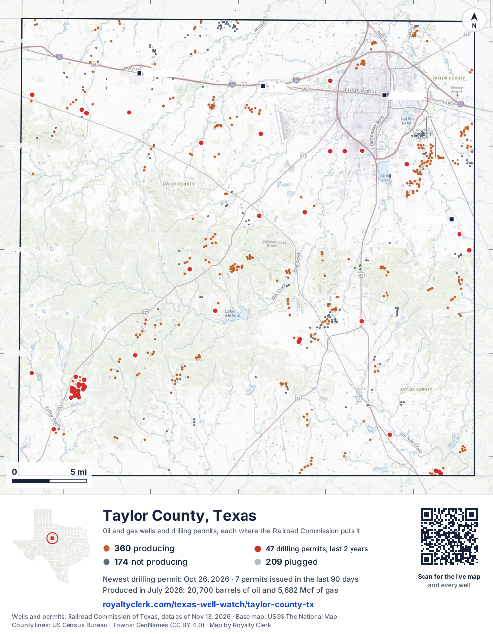
- Drilling locations47Permits issued in the last two years
- Producing wells360On a lease reporting production now
- Not producing174Shut in, inactive or no lease on record
- Plugged209The state's wellbore record says plugged
Sources: Railroad Commission of Texas well layers and permit files, US Census Bureau county outline, town points from GeoNames (CC BY 4.0), base map from USGS The National Map. A dot is a surface location; a horizontal well runs a mile or more from it.
743 wells with a location on the state's map and 47 drilling locations permitted in the last 24 months, each where the Railroad Commission puts it.
A permit is not a well.
Wells near each town in Taylor County
Wells within 10 miles of each town, on either side of the county line.
Use this map on your site
You may show this map on any site, unchanged. Keep the credit line and its link to Royalty Clerk under the map. The picture updates by itself as the state records new wells and permits.
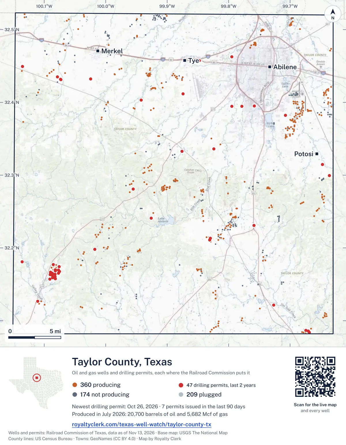
<a href="https://royaltyclerk.com/texas-well-watch/taylor-county-tx"><img src="https://royaltyclerk.com/maps/county-wells/taylor-county-tx.svg" alt="Map of Taylor County, Texas, with 743 oil and gas wells and 47 recent drilling locations as dots." width="1000" height="1285" loading="lazy" style="max-width:100%;height:auto;border:0"></a>
<p style="margin:4px 0 0;font-size:14px">Map: <a href="https://royaltyclerk.com/texas-well-watch/taylor-county-tx">Taylor County, Texas oil and gas wells</a> by Royalty Clerk, from Railroad Commission of Texas records</p>
The last twelve months
Month by month in Taylor County
| Month | Permits | Completions | First production |
|---|---|---|---|
| Oct 2026 | 2 | 0 | 0 |
| Sep 2026 | 4 | 0 | 0 |
| Aug 2026 | 8 | 1 | 0 |
| Jul 2026 | 1 | 1 | 0 |
| Jun 2026 | 6 | 0 | 0 |
| May 2026 | 3 | 2 | 0 |
| Apr 2026 | 1 | 1 | 0 |
| Feb 2026 | 1 | 0 | 0 |
| Dec 2025 | 1 | 1 | 0 |
| Nov 2025 | 1 | 0 | 0 |
Counted from November 15, 2025 to October 26, 2026, so the first and last months are partial. Source: Railroad Commission of Texas data sets.
Free, no sign-in
The newest drilling permits in Taylor County
| Issued | Lease and well | Operator | Drilling began | Depth, ft | API number | Coordinates | Permit |
|---|---|---|---|---|---|---|---|
| 2026-10-26 | HBPL-225.31 01new drill · verticalEnergy Transfer CompanyAPI 42-441-34748 · permit 091957032.23098, -99.75860400 ft | Energy Transfer Company | |||||
| 2026-10-08 | KISSELL UNIT 37WSnew drill · verticalL.c.s. Production CompanyAPI 42-441-34747 · permit 091904632.16454, -100.090004,999 ft | L.c.s. Production Company | |||||
| 2026-09-14 | ABILENE 1.0 GB - N FM 1235 01new drill · verticalEnergy Transfer CompanyAPI 42-441-34746 · permit 091849832.33269, -99.87592420 ft | Energy Transfer Company | |||||
| 2026-09-10 | JACKSON 3new drill · verticalL.c.s. Production CompanyAPI 42-441-34745 · permit 091841232.16526, -100.076944,999 ft | L.c.s. Production Company | |||||
| 2026-09-09 | JACKSON 2new drill · verticalL.c.s. Production CompanyAPI 42-441-34744 · permit 091841132.17406, -100.075784,999 ft | L.c.s. Production Company | |||||
| 2026-09-09 | JACKSON 1new drill · verticalL.c.s. Production CompanyAPI 42-441-34743 · permit 091840932.16941, -100.076814,999 ft | L.c.s. Production Company | |||||
| 2026-08-31 | KISSELL UNIT 26WInew drill · verticalL.c.s. Production CompanyAPI 42-441-34700 · permit 091820732.15715, -100.090634,999 ft | L.c.s. Production Company | |||||
| 2026-08-14 | TYE-SOUTH STREET 1new drill · verticalDelek Crude Logistics, LLCAPI 42-441-34742 · permit 091775032.45737, -99.84777300 ft | Delek Crude Logistics, LLC | |||||
| 2026-08-06 | KISSELL UNIT 21new drill · verticalL.c.s. Production CompanyAPI 42-441-34709 · permit 091744832.16316, -100.090414,999 ft | L.c.s. Production Company | |||||
| 2026-08-04 | KISSELL UNIT 23WSre-entry · verticalL.c.s. Production CompanyAPI 42-441-02616 · permit 091755932.16685, -100.089774,999 ft | L.c.s. Production Company | |||||
| 2026-08-04 | KISSELL UNIT 29new drill · verticalL.c.s. Production CompanyAPI 42-441-34710 · permit 091753232.16043, -100.08258drilling began 2026-08-07 · 4,999 ft | L.c.s. Production Company | |||||
| 2026-08-04 | KISSELL UNIT 27WInew drill · verticalL.c.s. Production CompanyAPI 42-441-34701 · permit 091743332.16316, -100.090414,999 ft | L.c.s. Production Company | |||||
| 2026-08-04 | KISSELL UNIT 31WInew drill · verticalL.c.s. Production CompanyAPI 42-441-34707 · permit 091740932.16871, -100.081984,999 ft | L.c.s. Production Company | |||||
| 2026-08-03 | KISSELL UNIT 28WInew drill · verticalL.c.s. Production CompanyAPI 42-441-34741 · permit 091740832.15766, -100.08206drilling began 2026-08-21 · 4,999 ft | L.c.s. Production Company | |||||
| 2026-07-29 | KISSELL UNIT 30WInew drill · verticalL.c.s. Production CompanyAPI 42-441-34705 · permit 091740132.16359, -100.082664,999 ft | L.c.s. Production Company | |||||
| 2026-06-26 | KISSELL UNIT 36new drill · verticalL.c.s. Production CompanyAPI 42-441-34739 · permit 091664932.16986, -100.081844,999 ft | L.c.s. Production Company | |||||
| 2026-06-23 | KISSELL 7WInew drill · verticalL.c.s. Production CompanyAPI 42-441-34695 · permit 091664532.17693, -100.08551drilling began 2026-07-10 · 4,999 ft | L.c.s. Production Company | |||||
| 2026-06-22 | FORREST-KENNEDY 1new drill · verticalVX Operating, LLCAPI 42-441-34737 · permit 091644432.24077, -99.92569drilling began 2026-07-20 · 4,999 ft | VX Operating, LLC | |||||
| 2026-06-19 | KISSELL UNIT 32new drill · verticalL.c.s. Production CompanyAPI 42-441-34738 · permit 091650832.16249, -100.086744,999 ft | L.c.s. Production Company | |||||
| 2026-06-19 | KISSELL UNIT 8new drill · verticalL.c.s. Production CompanyAPI 42-441-34697 · permit 091648732.15908, -100.08645drilling began 2026-07-25 · 4,999 ft | L.c.s. Production Company | |||||
| 2026-06-15 | KISSELL UNIT 5new drill · verticalL.c.s. Production CompanyAPI 42-441-34699 · permit 091629632.16515, -100.08695drilling began 2026-06-25 · 4,999 ft | L.c.s. Production Company | |||||
| 2026-05-19 | KISSELL 5WSre-entry · verticalL.c.s. Production CompanyAPI 42-441-00780 · permit 09156664,900 ft | L.c.s. Production Company | |||||
| 2026-05-19 | CH-180 1new drill · verticalEnterprise Products OperatingllcAPI 42-441-34736 · permit 091565132.29939, -99.63624400 ft | Enterprise Products Operatingllc | |||||
| 2026-05-19 | CH-160 1new drill · verticalEnterprise Products OperatingllcAPI 42-441-34735 · permit 091564832.40313, -99.94219400 ft | Enterprise Products Operatingllc | |||||
| 2026-04-22 | ORW MP 138 REPLACEMENT SOUKUP 1new drill · verticalMagellan Pipeline Company, L.P.API 42-441-34734 · permit 091497132.39479, -99.77862drilling began 2026-08-04 · 400 ft | Magellan Pipeline Company, L.P. | |||||
| 2026-02-27 | JOCELYN-VARN (FRY SAND) UNIT 4Wnew drill · verticalWinchester Energy, LLCAPI 42-441-34671 · permit 091371132.12692, -100.11051drilling began 2026-03-17 · 5,000 ft | Winchester Energy, LLC | |||||
| 2025-12-16 | SEARS 1new drill · verticalVX Operating, LLCAPI 42-441-34733 · permit 091219832.19817, -100.01755drilling began 2025-12-23 · 5,400 ft | VX Operating, LLC | |||||
| 2025-11-18 | DUNN 1new drill · verticalCanan Mowrey Operating, LLCAPI 42-441-34732 · permit 091178532.18073, -100.13567drilling began 2025-12-29 · 7,000 ft | Canan Mowrey Operating, LLC | |||||
| 2025-11-14 | CATHODIC PROTECTION 30new drill · verticalAtmos Pipeline - TexasAPI 42-441-34731 · permit 091139532.46242, -99.79473550 ft | Atmos Pipeline - Texas | |||||
| 2025-10-23 | DETTMANN 1Rnew drill · verticalReo Operating LLCAPI 42-441-34730 · permit 091128532.43155, -100.07328drilling began 2025-10-27 · 3,000 ft | Reo Operating LLC | |||||
| 2025-09-11 | DELEK4 001new drill · verticalDelek Crude Logistics, LLCAPI 42-441-34729 · permit 091019832.41162, -99.87428300 ft | Delek Crude Logistics, LLC | |||||
| 2025-08-19 | GRAY LINE GRAY SAND UNIT 9re-entry · verticalQuail Well Service, Inc.API 42-441-03649 · permit 090992132.08386, -99.668533,953 ft | Quail Well Service, Inc. | |||||
| 2025-08-15 | DETTMANN 1new drill · verticalReo Operating LLCAPI 42-441-34728 · permit 090985532.43130, -100.07303drilling began 2025-08-29 · 3,000 ft | Reo Operating LLC | |||||
| 2025-08-15 | GRAY LINE GRAY SAND UNIT 10new drill · verticalQuail Well Service, Inc.API 42-441-34727 · permit 090983732.08562, -99.670334,100 ft | Quail Well Service, Inc. | |||||
| 2025-06-02 | ANITA JACQUES ESTATE 1new drill · verticalDelray Oil, Inc.API 42-441-34726 · permit 090839032.31482, -99.64724drilling began 2025-09-08 · 4,100 ft | Delray Oil, Inc. | |||||
| 2025-05-19 | ORION WEST MP 142.3 REPLACEMENT 1new drill · verticalMagellan Pipeline Company, L.P.API 42-441-34725 · permit 090801132.38204, -99.70772500 ft | Magellan Pipeline Company, L.P. | |||||
| 2025-05-13 | CATHODIC PROTECTION 26new drill · verticalEnergy Transfer CompanyAPI 42-441-34724 · permit 090785532.39492, -99.75794600 ft | Energy Transfer Company | |||||
| 2025-05-07 | MP 154.9 154new drill · verticalEnterprise Products Texas Op LLCAPI 42-441-34723 · permit 090766032.43215, -100.02466400 ft | Enterprise Products Texas Op LLC | |||||
| 2025-05-02 | ORW MP 116.7 NEW SOUKUP 1new drill · verticalMagellan Pipeline Company, L.P.API 42-441-34722 · permit 090767432.44907, -100.13515550 ft | Magellan Pipeline Company, L.P. | |||||
| 2025-05-02 | ORW MP 120.2 NEW SOUKUP 1new drill · verticalMagellan Pipeline Company, L.P.API 42-441-34721 · permit 090767332.43479, -100.07846550 ft | Magellan Pipeline Company, L.P. | |||||
| 2025-04-25 | ORW MP 137.1 NEW SOUKUP 1new drill · verticalMagellan Pipeline Company, L.P.API 42-441-34720 · permit 090754932.39460, -99.79481550 ft | Magellan Pipeline Company, L.P. | |||||
| 2025-04-22 | JACKSON 4REre-entry · verticalL.c.s. Production CompanyAPI 42-441-30200 · permit 090752132.16742, -100.075254,730 ft | L.c.s. Production Company | |||||
| 2025-04-08 | GRAY LINE GRAY SAND UNIT 8re-entry · verticalQuail Well Service, Inc.API 42-441-80568 · permit 090716532.08660, -99.67429drilling began 2025-05-29 · 4,010 ft | Quail Well Service, Inc. | |||||
| 2025-03-19 | CATHODIC PROTECTION 24new drill · verticalAtmos Pipeline - TexasAPI 42-441-34719 · permit 090672532.33592, -99.82393430 ft | Atmos Pipeline - Texas | |||||
| 2025-01-21 | BROWN 3new drill · verticalEagle Capital Partners, LLCAPI 42-441-34718 · permit 090525132.21348, -99.82945drilling began 2026-03-31 · 5,000 ft | Eagle Capital Partners, LLC | |||||
| 2025-01-17 | BROWN 2new drill · verticalEagle Capital Partners, LLCAPI 42-441-34717 · permit 090524032.21112, -99.83079drilling began 2026-04-10 · 5,000 ft | Eagle Capital Partners, LLC | |||||
| 2025-01-02 | JANA 'B' 1new drill · verticalStetson Petroleum Corp.API 42-441-34716 · permit 090494032.12162, -99.72679drilling began 2025-01-15 · 5,000 ft | Stetson Petroleum Corp. | |||||
| 2024-11-22 | LEDBETTER 5recompletion · verticalStephens & Johnson Operating Co.API 42-441-34133 · permit 090421632.28103, -99.95525drilling began 2024-11-11 · 3,412 ft | Stephens & Johnson Operating Co. | |||||
| 2024-11-13 | POLLARD 1new drill · verticalTeal Exploration, LLCAPI 42-441-34715 · permit 090397132.49256, -99.711992,000 ft | Teal Exploration, LLC | |||||
| 2024-11-12 | SCHNEIDER 1WSre-entry · verticalL.c.s. Production CompanyAPI 42-441-32348 · permit 090389532.16240, -100.089674,500 ft | L.c.s. Production Company |
These are the newest 50 of 81 permits on file for Taylor County. The rest follow, 50 to a page.
A permit is permission to drill, not a well. Source: Railroad Commission of Texas drilling permit files.
Year by year
Drilling permits issued in Taylor County, by year
| Year | Permits issued |
|---|---|
| 2026 so far | 26 |
| 2025 | 21 |
| 2024 | 32 |
| 2023 | 2 |
Counted from the permit files we hold, which start in 2023; that first year may be partial. Source: Railroad Commission of Texas drilling permit files.
The latest
The most recent records
| Date | What, who and where |
|---|---|
| 2026-10-26 | Permit issued: Energy Transfer CompanyHBPL-225.31 · A-1515 · permit 0919570 |
| 2026-10-08 | Permit issued: L.c.s. Production CompanyKISSELL UNIT · A-138 · permit 0919046 |
| 2026-09-14 | Permit issued: Energy Transfer CompanyABILENE 1.0 GB - N FM 1235 · A-49 · permit 0918498 |
| 2026-09-10 | Permit issued: L.c.s. Production CompanyJACKSON · A-138 · permit 0918412 |
| 2026-09-09 | Permit issued: L.c.s. Production CompanyJACKSON · A-138 · permit 0918411 |
| 2026-09-09 | Permit issued: L.c.s. Production CompanyJACKSON · A-138 · permit 0918409 |
| 2026-08-31 | Permit issued: L.c.s. Production CompanyKISSELL UNIT · A-137 · permit 0918207 |
| 2026-08-14 | Permit issued: Delek Crude Logistics, LLCTYE-SOUTH STREET · A-1457 · permit 0917750 |
| 2026-08-06 | Permit issued: L.c.s. Production CompanyKISSELL UNIT · A-137 · permit 0917448 |
| 2026-08-04 | Permit issued: L.c.s. Production CompanyKISSELL UNIT · A-137 · permit 0917532 |
| 2026-08-04 | Permit issued: L.c.s. Production CompanyKISSELL UNIT · A-138 · permit 0917409 |
| 2026-08-04 | Permit issued: L.c.s. Production CompanyKISSELL UNIT · A-138 · permit 0917559 |
| 2026-08-04 | Permit issued: L.c.s. Production CompanyKISSELL UNIT · A-137 · permit 0917433 |
| 2026-08-04 | Completed: L.c.s. Production CompanyKISSELL UNIT · A-138 · permit 0916296 |
| 2026-08-03 | Permit issued: L.c.s. Production CompanyKISSELL UNIT · A-137 · permit 0917408 |
Coming up
First checks coming due in Taylor County
- GRAY LINE GRAY SAND UNIT, Quail Well Service, Inc.by November 28, 2026
- KISSELL UNIT, L.c.s. Production Companyby December 29, 2026
Follow it
Watch Taylor County, or one abstract
What do you want to follow?
Where the land is. Your deed or lease names it.
For example A-1119, or Bush, or T&P 38. Your deed or the tax bill has it.
Other counties
Drilling activity in other counties
Related
Related
- ToolTexas well watchPermit, completion, first production and when the first check is due.
- ToolIs this buyout offer fair?The offer as months of your income, what the acres mean, and the questions to ask.
- ToolIs this lease offer good?Bonus and royalty against the county, and a scan of the lease's clauses.
- Texas dataTexas operator changesWho took over whose leases in the last 24 months.
- ToolLate payment interestDeadlines and the interest a late payment earns.
- Texas dataTexas oil and gas atlas254 counties, every lease, operator and field.
FAQ
Questions people ask
How many wells were permitted in Taylor County in the last year?
The Railroad Commission issued 28 drilling permits in Taylor County in the twelve months to October 26, 2026, and recorded 6 completions and 0 first-production reports. A permit is permission to drill, not a well.
How do I get an alert when a permit is issued near my land in Taylor County?
Choose your abstract on this page, or the whole county, and sign in. You get one email a week, only when something new is recorded after you sign up. The alert says whether an event is on an interest in your Mineral File, on a place you follow, or only nearby.
When is my first royalty check due after a new well?
Natural Resources Code section 91.402(a) says on or before 120 days after the end of the month of first sale of production from the well. The state's first-production month is the closest public marker, so the date on this page is the earliest, not a certainty.
Got a new well on your land?
The first check is due within 120 days after the end of the month of first sale.
Sources
Primary sources, opened on 29 September 2026. Statute text is the current version on statutes.capitol.texas.gov.