
Washington County, Texas
Washington County drilling permits: what the state recorded
- 47drilling permits
- 7completions
- 6first-production reports
- in the last twelve months
Wells by coordinates
Oil wells and drilling locations in Washington County
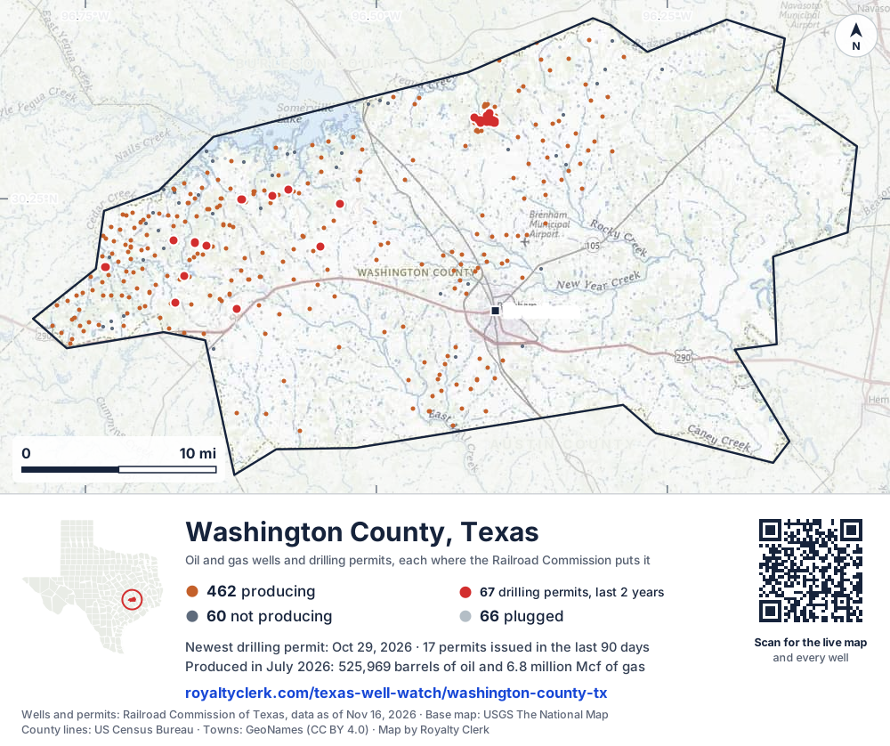
- Drilling locations67Permits issued in the last two years
- Producing wells462On a lease reporting production now
- Not producing60Shut in, inactive or no lease on record
- Plugged66The state's wellbore record says plugged
Sources: Railroad Commission of Texas well layers and permit files, US Census Bureau county outline, town points from GeoNames (CC BY 4.0), base map from USGS The National Map. A dot is a surface location; a horizontal well runs a mile or more from it.
588 wells with a location on the state's map and 67 drilling locations permitted in the last 24 months, each where the Railroad Commission puts it.
A permit is not a well.
Washington County is one of the 27 counties of the Eagle Ford Shale
Wells near each town in Washington County
Wells within 10 miles of each town, on either side of the county line.
Use this map on your site
You may show this map on any site, unchanged. Keep the credit line and its link to Royalty Clerk under the map. The picture updates by itself as the state records new wells and permits.
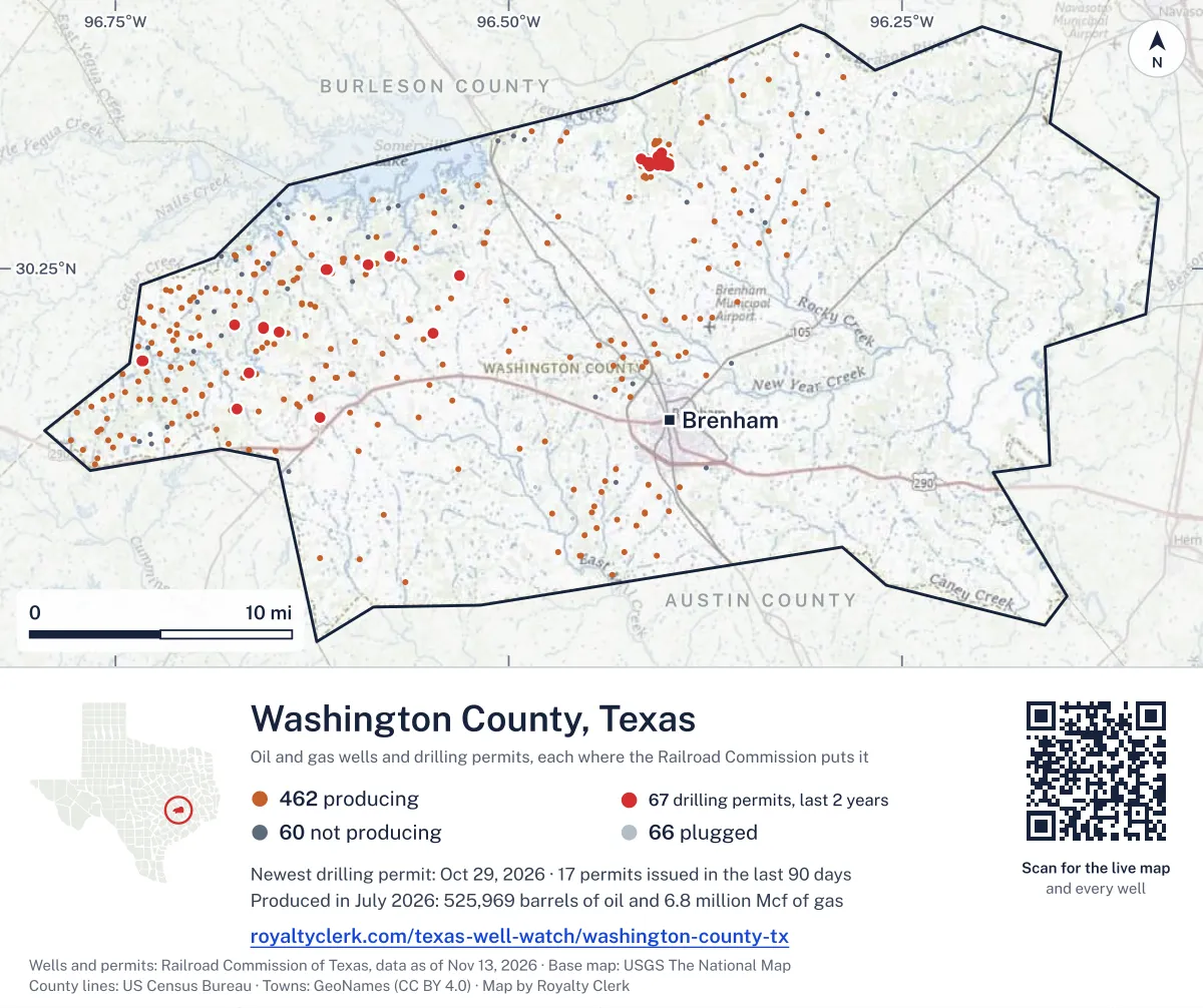
<a href="https://royaltyclerk.com/texas-well-watch/washington-county-tx"><img src="https://royaltyclerk.com/maps/county-wells/washington-county-tx.svg" alt="Map of Washington County, Texas, with 588 oil and gas wells and 67 recent drilling locations as dots." width="1000" height="838" loading="lazy" style="max-width:100%;height:auto;border:0"></a>
<p style="margin:4px 0 0;font-size:14px">Map: <a href="https://royaltyclerk.com/texas-well-watch/washington-county-tx">Washington County, Texas oil and gas wells</a> by Royalty Clerk, from Railroad Commission of Texas records</p>
The last twelve months
Month by month in Washington County
| Month | Permits | Completions | First production |
|---|---|---|---|
| Oct 2026 | 1 | 0 | 0 |
| Sep 2026 | 1 | 0 | 0 |
| Aug 2026 | 22 | 0 | 0 |
| Jul 2026 | 6 | 0 | 0 |
| Jun 2026 | 2 | 0 | 0 |
| Apr 2026 | 6 | 0 | 0 |
| Mar 2026 | 1 | 0 | 0 |
| Feb 2026 | 0 | 3 | 2 |
| Jan 2026 | 4 | 0 | 0 |
| Dec 2025 | 1 | 4 | 4 |
| Nov 2025 | 3 | 0 | 0 |
Counted from November 17, 2025 to October 29, 2026, so the first and last months are partial. Source: Railroad Commission of Texas data sets.
Free, no sign-in
The newest drilling permits in Washington County
| Issued | Lease and well | Operator | Drilling began | Depth, ft | API number | Coordinates | Permit |
|---|---|---|---|---|---|---|---|
| 2026-10-29 | CLAY CREEK EAST UNIT 530new drill · verticalAethon Energy Operating LLCAPI 42-477-31372 · permit 091974830.30620, -96.398552,000 ft | Aethon Energy Operating LLC | |||||
| 2026-09-02 | CLAY CREEK EAST UNIT 633new drill · verticalAethon Energy Operating LLCAPI 42-477-31370 · permit 091822530.30732, -96.401912,000 ft | Aethon Energy Operating LLC | |||||
| 2026-08-31 | CLAY CREEK EAST UNIT 631new drill · verticalAethon Energy Operating LLCAPI 42-477-31369 · permit 091822330.31152, -96.404932,000 ft | Aethon Energy Operating LLC | |||||
| 2026-08-31 | CLAY CREEK EAST UNIT 630new drill · verticalAethon Energy Operating LLCAPI 42-477-31368 · permit 091819830.31028, -96.402832,000 ft | Aethon Energy Operating LLC | |||||
| 2026-08-31 | CLAY CREEK EAST UNIT 629new drill · verticalAethon Energy Operating LLCAPI 42-477-31367 · permit 091819730.31005, -96.402532,000 ft | Aethon Energy Operating LLC | |||||
| 2026-08-31 | CLAY CREEK EAST UNIT 529new drill · verticalAethon Energy Operating LLCAPI 42-477-31366 · permit 091816630.30784, -96.398452,000 ft | Aethon Energy Operating LLC | |||||
| 2026-08-31 | CLAY CREEK EAST UNIT 528new drill · verticalAethon Energy Operating LLCAPI 42-477-31365 · permit 091816530.30819, -96.400032,000 ft | Aethon Energy Operating LLC | |||||
| 2026-08-31 | CLAY CREEK EAST UNIT 526new drill · verticalAethon Energy Operating LLCAPI 42-477-31364 · permit 091816030.30629, -96.398652,000 ft | Aethon Energy Operating LLC | |||||
| 2026-08-31 | CLAY CREEK EAST UNIT 525new drill · verticalAethon Energy Operating LLCAPI 42-477-31363 · permit 091815730.30677, -96.399332,000 ft | Aethon Energy Operating LLC | |||||
| 2026-08-31 | CLAY CREEK EAST UNIT 128new drill · verticalAethon Energy Operating LLCAPI 42-477-31362 · permit 091814430.30784, -96.403202,000 ft | Aethon Energy Operating LLC | |||||
| 2026-08-26 | CLAY CREEK EAST UNIT 127new drill · verticalAethon Energy Operating LLCAPI 42-477-31361 · permit 091809030.30727, -96.404832,000 ft | Aethon Energy Operating LLC | |||||
| 2026-08-26 | CLAY CREEK EAST UNIT 99new drill · verticalAethon Energy Operating LLCAPI 42-477-31360 · permit 091808930.31350, -96.402812,000 ft | Aethon Energy Operating LLC | |||||
| 2026-08-26 | CLAY CREEK WEST UNIT 264new drill · verticalAethon Energy Operating LLCAPI 42-477-31359 · permit 091807930.31042, -96.415522,000 ft | Aethon Energy Operating LLC | |||||
| 2026-08-25 | CLAY CREEK WEST UNIT 262new drill · verticalAethon Energy Operating LLCAPI 42-477-31357 · permit 091804830.30815, -96.411682,000 ft | Aethon Energy Operating LLC | |||||
| 2026-08-25 | CLAY CREEK WEST UNIT 261new drill · verticalAethon Energy Operating LLCAPI 42-477-31356 · permit 091804130.30645, -96.410452,000 ft | Aethon Energy Operating LLC | |||||
| 2026-08-25 | CLAY CREEK WEST UNIT 260new drill · verticalAethon Energy Operating LLCAPI 42-477-31355 · permit 091804030.30761, -96.410542,000 ft | Aethon Energy Operating LLC | |||||
| 2026-08-25 | CLAY CREEK WEST UNIT 259new drill · verticalAethon Energy Operating LLCAPI 42-477-31354 · permit 091803930.30816, -96.410562,000 ft | Aethon Energy Operating LLC | |||||
| 2026-08-18 | TRUMAN FIVE H 05TMnew drill · horizontalMagnolia Oil & Gas Operating LLCAPI 42-477-31353 · permit 091785930.21539, -96.6461612,000 ft | Magnolia Oil & Gas Operating LLC | |||||
| 2026-08-18 | TRUMAN THREE H 03TMnew drill · horizontalMagnolia Oil & Gas Operating LLCAPI 42-477-31352 · permit 091781630.21533, -96.6462312,000 ft | Magnolia Oil & Gas Operating LLC | |||||
| 2026-08-14 | MAC ARTHUR UNIT H 04TMnew drill · horizontalMagnolia Oil & Gas Operating LLCAPI 42-477-31351 · permit 091781430.21536, -96.6462012,000 ft | Magnolia Oil & Gas Operating LLC | |||||
| 2026-08-13 | TRUMAN ONE H 01TMnew drill · horizontalMagnolia Oil & Gas Operating LLCAPI 42-477-31349 · permit 091773230.21526, -96.6463212,000 ft | Magnolia Oil & Gas Operating LLC | |||||
| 2026-08-12 | TRUMAN SEVEN H 07TMnew drill · horizontalMagnolia Oil & Gas Operating LLCAPI 42-477-31350 · permit 091773330.21545, -96.6461012,000 ft | Magnolia Oil & Gas Operating LLC | |||||
| 2026-08-12 | MAC ARTHUR UNIT H 06TMnew drill · horizontalMagnolia Oil & Gas Operating LLCAPI 42-477-31348 · permit 091773130.21542, -96.6461312,000 ft | Magnolia Oil & Gas Operating LLC | |||||
| 2026-08-12 | MAC ARTHUR UNIT H 02TMnew drill · horizontalMagnolia Oil & Gas Operating LLCAPI 42-477-31347 · permit 091773030.21529, -96.6462812,000 ft | Magnolia Oil & Gas Operating LLC | |||||
| 2026-07-09 | BIG AL ELEVEN H 11BEnew drill · horizontalMagnolia Oil & Gas Operating LLCAPI 42-477-31346 · permit 091690130.19269, -96.66491drilling began 2026-08-27 · 12,000 ft | Magnolia Oil & Gas Operating LLC | |||||
| 2026-07-09 | BIG AL NINE H 09BEnew drill · horizontalMagnolia Oil & Gas Operating LLCAPI 42-477-31345 · permit 091690030.19272, -96.66494drilling began 2026-08-26 · 12,000 ft | Magnolia Oil & Gas Operating LLC | |||||
| 2026-07-09 | BIG AL SEVEN H 07BEnew drill · horizontalMagnolia Oil & Gas Operating LLCAPI 42-477-31344 · permit 091689930.19274, -96.66497drilling began 2026-08-25 · 12,000 ft | Magnolia Oil & Gas Operating LLC | |||||
| 2026-07-09 | MEANS 'C' H 05BEnew drill · horizontalMagnolia Oil & Gas Operating LLCAPI 42-477-31343 · permit 091689730.19280, -96.66504drilling began 2026-08-24 · 12,000 ft | Magnolia Oil & Gas Operating LLC | |||||
| 2026-07-09 | MEANS 'C' H 03BEnew drill · horizontalMagnolia Oil & Gas Operating LLCAPI 42-477-31342 · permit 091689630.19277, -96.66501drilling began 2026-08-25 · 12,000 ft | Magnolia Oil & Gas Operating LLC | |||||
| 2026-07-08 | CRIMSON BEAR H 02BEnew drill · horizontalMagnolia Oil & Gas Operating LLCAPI 42-477-31341 · permit 091688230.19283, -96.66508drilling began 2026-08-23 · 12,000 ft | Magnolia Oil & Gas Operating LLC | |||||
| 2026-06-03 | GSWF BRAVO AW 2Hnew drill · horizontalGeosouthern Operating II, LLCAPI 42-477-31340 · permit 091573430.21468, -96.54825drilling began 2026-07-06 · 13,500 ft | Geosouthern Operating II, LLC | |||||
| 2026-06-03 | GSWF ALPHA AW 1Hnew drill · horizontalGeosouthern Operating II, LLCAPI 42-477-31339 · permit 091567430.21472, -96.54829drilling began 2026-07-03 · 13,500 ft | Geosouthern Operating II, LLC | |||||
| 2026-04-09 | MOAB ELEVEN H 11MAnew drill · horizontalMagnolia Oil & Gas Operating LLCAPI 42-477-31338 · permit 091461030.19947, -96.73275drilling began 2026-05-21 · 12,000 ft | Magnolia Oil & Gas Operating LLC | |||||
| 2026-04-09 | MOAB NINE H 09MAnew drill · horizontalMagnolia Oil & Gas Operating LLCAPI 42-477-31337 · permit 091460930.19944, -96.73280drilling began 2026-05-20 · 12,000 ft | Magnolia Oil & Gas Operating LLC | |||||
| 2026-04-09 | MOAB SEVEN H 07MAnew drill · horizontalMagnolia Oil & Gas Operating LLCAPI 42-477-31336 · permit 091460730.19941, -96.73286drilling began 2026-05-19 · 12,000 ft | Magnolia Oil & Gas Operating LLC | |||||
| 2026-04-09 | MOAB FIVE H 05MAnew drill · horizontalMagnolia Oil & Gas Operating LLCAPI 42-477-31335 · permit 091460630.19938, -96.73291drilling began 2026-05-18 · 12,000 ft | Magnolia Oil & Gas Operating LLC | |||||
| 2026-04-09 | MOAB THREE H 03MAnew drill · horizontalMagnolia Oil & Gas Operating LLCAPI 42-477-31334 · permit 091460530.19935, -96.73296drilling began 2026-05-17 · 12,000 ft | Magnolia Oil & Gas Operating LLC | |||||
| 2026-04-09 | MOAB ONE H 01MAnew drill · horizontalMagnolia Oil & Gas Operating LLCAPI 42-477-31333 · permit 091460330.19931, -96.73301drilling began 2026-05-16 · 12,000 ft | Magnolia Oil & Gas Operating LLC | |||||
| 2026-03-31 | HAP-NEINAST 1Hnew drill · horizontalGeosouthern Operating II, LLCAPI 42-477-31248 · permit 091442430.24652, -96.53095drilling began 2026-05-26 · 13,500 ft | Geosouthern Operating II, LLC | |||||
| 2026-01-29 | BUZZ SEVEN H 07BYnew drill · horizontalMagnolia Oil & Gas Operating LLCAPI 42-477-31332 · permit 091310030.25656, -96.57561drilling began 2026-03-04 · 12,000 ft | Magnolia Oil & Gas Operating LLC | |||||
| 2026-01-29 | BUZZ THREE H 03BYnew drill · horizontalMagnolia Oil & Gas Operating LLCAPI 42-477-31330 · permit 091309830.25650, -96.57551drilling began 2026-03-06 · 12,000 ft | Magnolia Oil & Gas Operating LLC | |||||
| 2026-01-29 | BUZZ ONE H 01BYnew drill · horizontalMagnolia Oil & Gas Operating LLCAPI 42-477-31329 · permit 091309730.25647, -96.57546drilling began 2026-03-06 · 12,000 ft | Magnolia Oil & Gas Operating LLC | |||||
| 2026-01-28 | BUZZ FIVE H 05BYnew drill · horizontalMagnolia Oil & Gas Operating LLCAPI 42-477-31331 · permit 091309930.25653, -96.5755612,000 ft | Magnolia Oil & Gas Operating LLC | |||||
| 2025-12-03 | EAGLE EIGHT H 08BEnew drill · horizontalMagnolia Oil & Gas Operating LLCAPI 42-477-31328 · permit 091198130.24942, -96.61547drilling began 2025-12-23 · 12,500 ft | Magnolia Oil & Gas Operating LLC | |||||
| 2025-11-20 | EAGLE SIX H 06BEnew drill · horizontalMagnolia Oil & Gas Operating LLCAPI 42-477-31327 · permit 091177430.24956, -96.6155212,500 ft | Magnolia Oil & Gas Operating LLC | |||||
| 2025-11-20 | EAGLE FOUR H 04BEnew drill · horizontalMagnolia Oil & Gas Operating LLCAPI 42-477-31326 · permit 091177330.24946, -96.6154812,500 ft | Magnolia Oil & Gas Operating LLC | |||||
| 2025-11-20 | EAGLE TWO H 02BEnew drill · horizontalMagnolia Oil & Gas Operating LLCAPI 42-477-31325 · permit 091177230.24951, -96.6155012,500 ft | Magnolia Oil & Gas Operating LLC | |||||
| 2025-10-15 | AUBURN FOUR H 04AAnew drill · horizontalMagnolia Oil & Gas Operating LLCAPI 42-477-31324 · permit 091104130.21752, -96.65594drilling began 2025-10-30 · 12,000 ft | Magnolia Oil & Gas Operating LLC | |||||
| 2025-10-15 | AUBURN TEN H 10AAnew drill · horizontalMagnolia Oil & Gas Operating LLCAPI 42-477-31323 · permit 091103830.21745, -96.6558512,000 ft | Magnolia Oil & Gas Operating LLC | |||||
| 2025-10-15 | AUBURN EIGHT H 08AAnew drill · horizontalMagnolia Oil & Gas Operating LLCAPI 42-477-31322 · permit 091103630.21741, -96.65580drilling began 2025-11-01 · 12,000 ft | Magnolia Oil & Gas Operating LLC |
These are the newest 50 of 116 permits on file for Washington County. The rest follow, 50 to a page.
A permit is permission to drill, not a well. Source: Railroad Commission of Texas drilling permit files.
Year by year
Drilling permits issued in Washington County, by year
| Year | Permits issued |
|---|---|
| 2026 so far | 43 |
| 2025 | 20 |
| 2024 | 23 |
| 2023 | 20 |
| 2022 | 4 |
| 2021 | 1 |
| 2014 | 1 |
| 2013 | 2 |
| 2010 | 1 |
| 2003 | 1 |
Counted from the permit files we hold, which start in 2003; that first year may be partial. Source: Railroad Commission of Texas drilling permit files.
The latest
The most recent records
| Date | What, who and where |
|---|---|
| 2026-10-29 | Permit issued: Aethon Energy Operating LLCCLAY CREEK EAST UNIT · A-29 · permit 0919748 |
| 2026-09-02 | Permit issued: Aethon Energy Operating LLCCLAY CREEK EAST UNIT · A-93 · permit 0918225 |
| 2026-08-31 | Permit issued: Aethon Energy Operating LLCCLAY CREEK EAST UNIT · A-93 · permit 0918223 |
| 2026-08-31 | Permit issued: Aethon Energy Operating LLCCLAY CREEK EAST UNIT · A-93 · permit 0918198 |
| 2026-08-31 | Permit issued: Aethon Energy Operating LLCCLAY CREEK EAST UNIT · A-93 · permit 0918197 |
| 2026-08-31 | Permit issued: Aethon Energy Operating LLCCLAY CREEK EAST UNIT · A-29 · permit 0918166 |
| 2026-08-31 | Permit issued: Aethon Energy Operating LLCCLAY CREEK EAST UNIT · A-29 · permit 0918165 |
| 2026-08-31 | Permit issued: Aethon Energy Operating LLCCLAY CREEK EAST UNIT · A-29 · permit 0918160 |
| 2026-08-31 | Permit issued: Aethon Energy Operating LLCCLAY CREEK EAST UNIT · A-29 · permit 0918157 |
| 2026-08-31 | Permit issued: Aethon Energy Operating LLCCLAY CREEK EAST UNIT · A-93 · permit 0918144 |
| 2026-08-26 | Permit issued: Aethon Energy Operating LLCCLAY CREEK EAST UNIT · A-93 · permit 0918090 |
| 2026-08-26 | Permit issued: Aethon Energy Operating LLCCLAY CREEK EAST UNIT · A-93 · permit 0918089 |
| 2026-08-26 | Permit issued: Aethon Energy Operating LLCCLAY CREEK WEST UNIT · A-93 · permit 0918079 |
| 2026-08-25 | Permit issued: Aethon Energy Operating LLCCLAY CREEK WEST UNIT · A-93 · permit 0918048 |
| 2026-08-25 | Permit issued: Aethon Energy Operating LLCCLAY CREEK WEST UNIT · A-93 · permit 0918041 |
Follow it
Watch Washington County, or one abstract
What do you want to follow?
Where the land is. Your deed or lease names it.
For example A-1119, or Bush, or T&P 38. Your deed or the tax bill has it.
Other counties
Drilling activity in other counties
Related
Related
- ToolTexas well watchPermit, completion, first production and when the first check is due.
- ToolIs this buyout offer fair?The offer as months of your income, what the acres mean, and the questions to ask.
- ToolIs this lease offer good?Bonus and royalty against the county, and a scan of the lease's clauses.
- Texas dataTexas operator changesWho took over whose leases in the last 24 months.
- ToolLate payment interestDeadlines and the interest a late payment earns.
- Texas dataTexas oil and gas atlas254 counties, every lease, operator and field.
FAQ
Questions people ask
How many wells were permitted in Washington County in the last year?
The Railroad Commission issued 47 drilling permits in Washington County in the twelve months to October 29, 2026, and recorded 7 completions and 6 first-production reports. A permit is permission to drill, not a well.
How do I get an alert when a permit is issued near my land in Washington County?
Choose your abstract on this page, or the whole county, and sign in. You get one email a week, only when something new is recorded after you sign up. The alert says whether an event is on an interest in your Mineral File, on a place you follow, or only nearby.
When is my first royalty check due after a new well?
Natural Resources Code section 91.402(a) says on or before 120 days after the end of the month of first sale of production from the well. The state's first-production month is the closest public marker, so the date on this page is the earliest, not a certainty.
Got a new well on your land?
The first check is due within 120 days after the end of the month of first sale.
Sources
Primary sources, opened on 29 September 2026. Statute text is the current version on statutes.capitol.texas.gov.