
Wise County, Texas
Wise County drilling permits: what the state recorded
- 28drilling permits
- 51completions
- 22first-production reports
- in the last twelve months
Wells by coordinates
Oil wells and drilling locations in Wise County
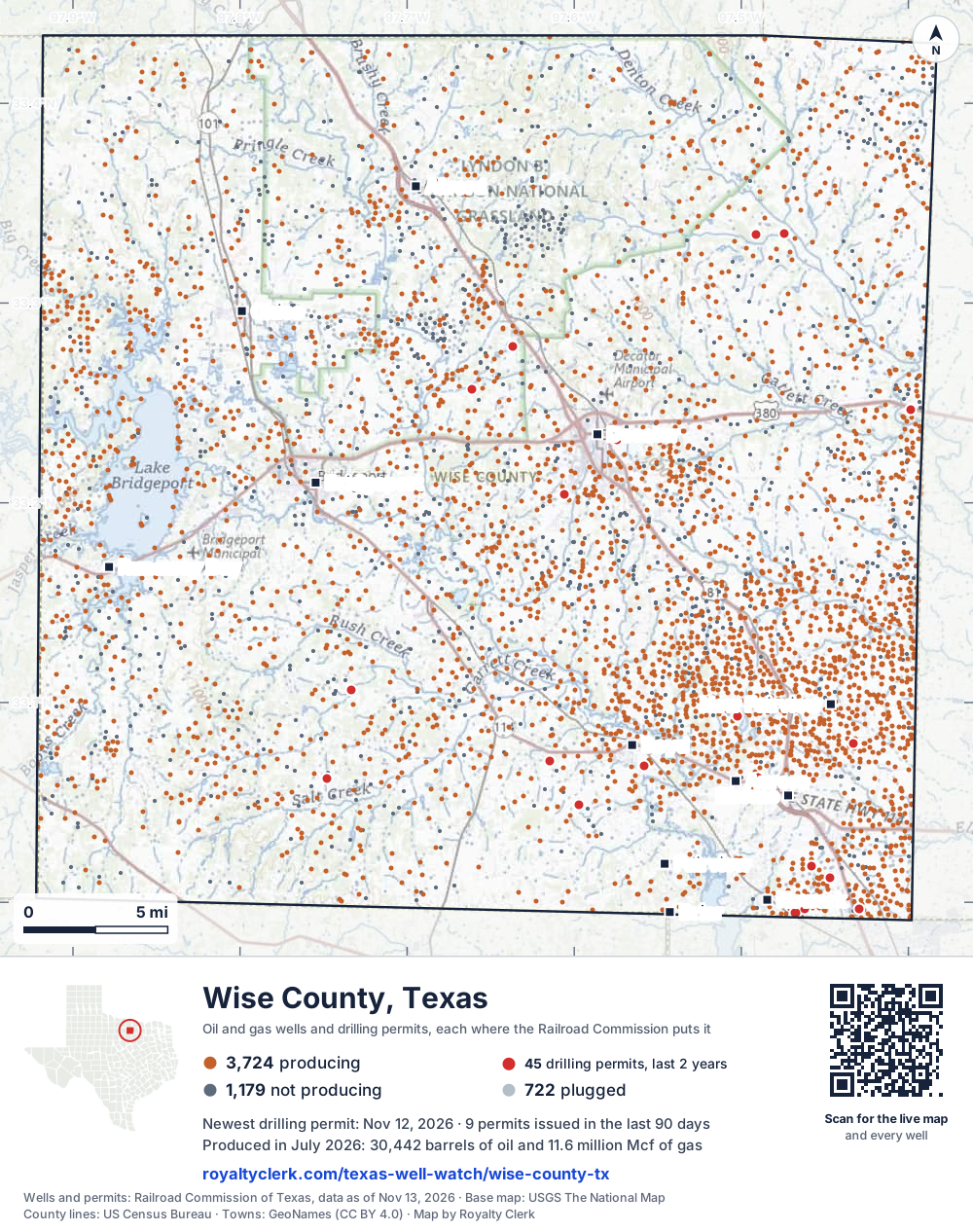
- Drilling locations45Permits issued in the last two years
- Producing wells3,724On a lease reporting production now
- Not producing1,179Shut in, inactive or no lease on record
- Plugged722The state's wellbore record says plugged
Sources: Railroad Commission of Texas well layers and permit files, US Census Bureau county outline, town points from GeoNames (CC BY 4.0), base map from USGS The National Map. A dot is a surface location; a horizontal well runs a mile or more from it.
5,625 wells with a location on the state's map and 45 drilling locations permitted in the last 24 months, each where the Railroad Commission puts it.
A permit is not a well.
Wells near each town in Wise County
- Alvord1,316 wells
- Aurora3,544 wells
- Boyd2,870 wells
- Briar2,626 wells
- Bridgeport1,780 wells
- Chico1,506 wells
- Decatur2,278 wells
- Fairview2,807 wells
- Newark3,366 wells
- New Fairview4,026 wells
- Rhome3,852 wells
- Runaway Bay1,615 wells
Wells within 10 miles of each town, on either side of the county line.
Use this map on your site
You may show this map on any site, unchanged. Keep the credit line and its link to Royalty Clerk under the map. The picture updates by itself as the state records new wells and permits.
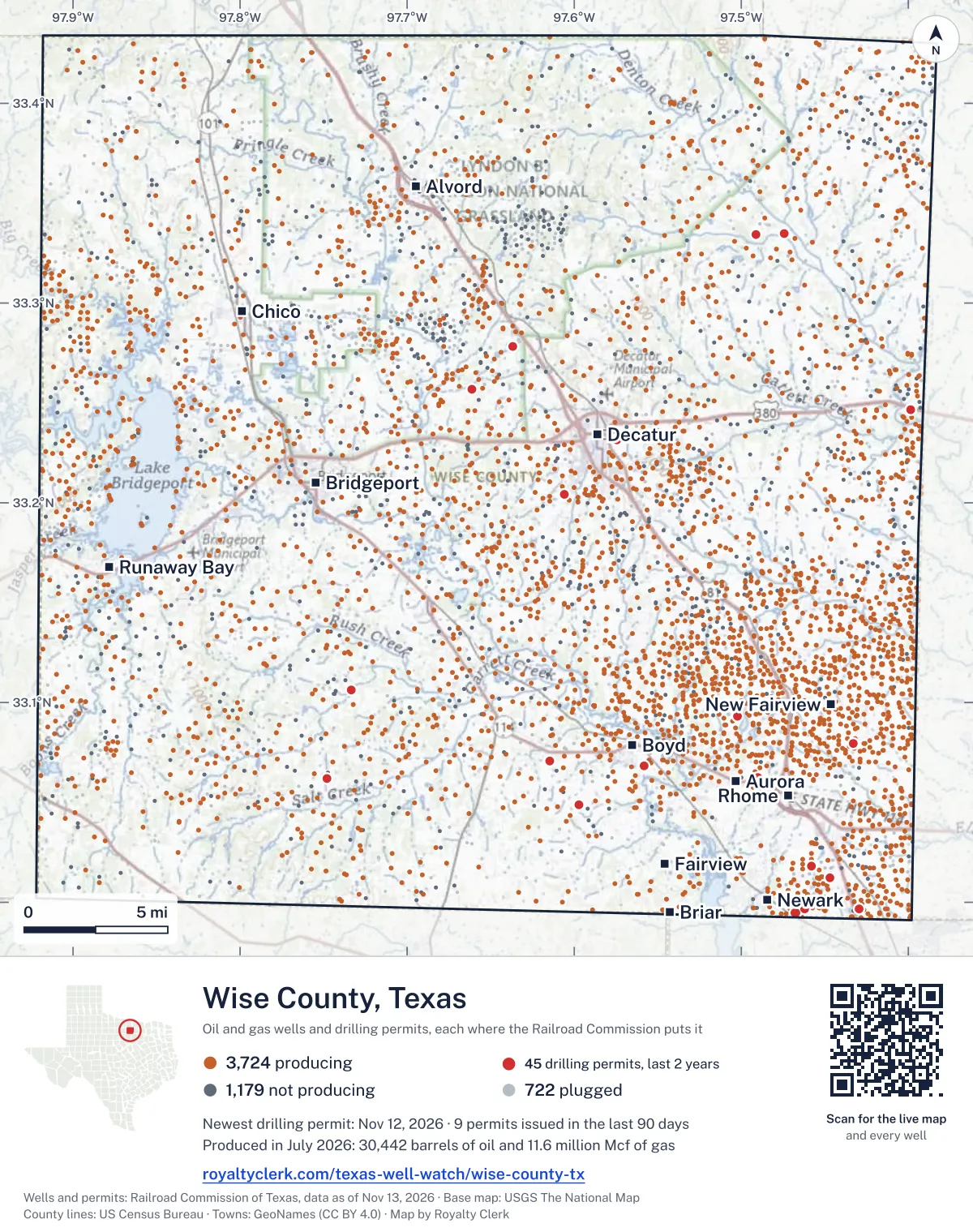
<a href="https://royaltyclerk.com/texas-well-watch/wise-county-tx"><img src="https://royaltyclerk.com/maps/county-wells/wise-county-tx.svg" alt="Map of Wise County, Texas, with 5,625 oil and gas wells and 45 recent drilling locations as dots." width="1000" height="1266" loading="lazy" style="max-width:100%;height:auto;border:0"></a>
<p style="margin:4px 0 0;font-size:14px">Map: <a href="https://royaltyclerk.com/texas-well-watch/wise-county-tx">Wise County, Texas oil and gas wells</a> by Royalty Clerk, from Railroad Commission of Texas records</p>
The last twelve months
Month by month in Wise County
| Month | Permits | Completions | First production |
|---|---|---|---|
| Nov 2026 | 3 | 0 | 0 |
| Sep 2026 | 6 | 0 | 0 |
| Aug 2026 | 3 | 6 | 4 |
| Jul 2026 | 4 | 7 | 0 |
| Jun 2026 | 2 | 8 | 0 |
| May 2026 | 4 | 4 | 0 |
| Apr 2026 | 0 | 4 | 2 |
| Mar 2026 | 3 | 3 | 3 |
| Feb 2026 | 0 | 7 | 8 |
| Jan 2026 | 1 | 5 | 2 |
| Dec 2025 | 2 | 5 | 3 |
| Nov 2025 | 0 | 2 | 0 |
Counted from November 16, 2025 to November 12, 2026, so the first and last months are partial. Source: Railroad Commission of Texas data sets.
Free, no sign-in
The newest drilling permits in Wise County
| Issued | Lease and well | Operator | Drilling began | Depth, ft | API number | Coordinates | Permit |
|---|---|---|---|---|---|---|---|
| 2026-11-12 | INDIAN CREEK R 6 (AW) 6Hnew drill · horizontalBKV North Texas, LLCAPI 42-497-38169 · permit 091916332.99679, -97.4619814,482 ft | BKV North Texas, LLC | |||||
| 2026-11-04 | INDIAN CREEK R 8 (AW) 8Hnew drill · horizontalBKV North Texas, LLCAPI 42-497-38171 · permit 091916532.99668, -97.4619812,610 ft | BKV North Texas, LLC | |||||
| 2026-11-04 | INDIAN CREEK R 7 (AW) 7Hnew drill · horizontalBKV North Texas, LLCAPI 42-497-38170 · permit 091916432.99673, -97.4619811,064 ft | BKV North Texas, LLC | |||||
| 2026-09-24 | MASON, ROSE 6 (AW) 6Hnew drill · horizontalBKV Barnett, LLCAPI 42-497-38168 · permit 091865633.24682, -97.3986016,573 ft | BKV Barnett, LLC | |||||
| 2026-09-24 | MASON, ROSE 4 (AW) 4Hnew drill · horizontalBKV Barnett, LLCAPI 42-497-38166 · permit 091800333.24679, -97.398478,879 ft | BKV Barnett, LLC | |||||
| 2026-09-21 | FARLOW, J F GU A 5 (AW) 5Hrecompletion · horizontalBKV Barnett, LLCAPI 42-497-35575 · permit 091872333.06829, -97.558447,412 ft | BKV Barnett, LLC | |||||
| 2026-09-14 | DECATUR GU 3 1 (AW) 1Hrecompletion · horizontalBKV Barnett, LLCAPI 42-497-35985 · permit 091853133.23135, -97.5742311,924 ft | BKV Barnett, LLC | |||||
| 2026-09-11 | MASON, ROSE 5 (AW) 5Hnew drill · horizontalBKV Barnett, LLCAPI 42-497-38167 · permit 091800533.24680, -97.398539,637 ft | BKV Barnett, LLC | |||||
| 2026-09-11 | MASON, ROSE 3 (AW) 3Hnew drill · horizontalBKV Barnett, LLCAPI 42-497-38165 · permit 091800233.24677, -97.398417,293 ft | BKV Barnett, LLC | |||||
| 2026-08-13 | MURPHY 2Hnew drill · horizontalLakota Energy, Ltd.API 42-497-38164 · permit 091764633.06212, -97.747747,500 ft | Lakota Energy, Ltd. | |||||
| 2026-08-12 | MCALISTER, O H GU 21 (AW) 21Hrecompletion · horizontalBKV Barnett, LLCAPI 42-497-36195 · permit 091752833.06265, -97.490319,500 ft | BKV Barnett, LLC | |||||
| 2026-08-07 | MURPHY 1Hnew drill · horizontalLakota Energy, Ltd.API 42-497-38163 · permit 091764533.06207, -97.747757,500 ft | Lakota Energy, Ltd. | |||||
| 2026-07-28 | VINSON FEE B 7 (AW) 7Hnew drill · horizontalBKV North Texas, LLCAPI 42-497-38159 · permit 091647733.01242, -97.44693drilling began 2026-08-14 · 12,452 ft | BKV North Texas, LLC | |||||
| 2026-07-22 | VINSON FEE B 4 (AW) 4Hnew drill · horizontalBKV North Texas, LLCAPI 42-497-38158 · permit 091647033.01242, -97.44712drilling began 2026-08-16 · 10,369 ft | BKV North Texas, LLC | |||||
| 2026-07-08 | STEVENS 1Hnew drill · horizontalLakota Energy, Ltd.API 42-497-38162 · permit 091690333.10605, -97.73367drilling began 2026-08-29 · 7,500 ft | Lakota Energy, Ltd. | |||||
| 2026-07-02 | VINSON FEE B 5 (AW) 5Hnew drill · horizontalBKV North Texas, LLCAPI 42-497-38160 · permit 091647833.01242, -97.44706drilling began 2026-08-15 · 11,359 ft | BKV North Texas, LLC | |||||
| 2026-06-26 | VINSON FEE B 6 (AW) 6Hnew drill · horizontalBKV North Texas, LLCAPI 42-497-38161 · permit 091647933.01242, -97.44700drilling began 2026-08-15 · 11,603 ft | BKV North Texas, LLC | |||||
| 2026-06-23 | WILSON, JACK GU 6Hrecompletion · horizontalBKV Barnett, LLCAPI 42-497-36063 · permit 091643632.99662, -97.429228,800 ft | BKV Barnett, LLC | |||||
| 2026-05-06 | RUTHERFORD-GRIFFETH DEEP 4 (AW) 4Hnew drill · horizontalBKV Barnett, LLCAPI 42-497-38157 · permit 091535733.33432, -97.4911316,159 ft | BKV Barnett, LLC | |||||
| 2026-05-06 | RUTHERFORD-GRIFFETH DEEP 3 (AW) 3Hnew drill · horizontalBKV Barnett, LLCAPI 42-497-38156 · permit 091535633.33428, -97.4911714,861 ft | BKV Barnett, LLC | |||||
| 2026-05-06 | RUTHERFORD-GRIFFETH DEEP 2 (AW) 2Hnew drill · horizontalBKV Barnett, LLCAPI 42-497-38155 · permit 091535533.33424, -97.4912214,861 ft | BKV Barnett, LLC | |||||
| 2026-05-06 | RUTHERFORD-GRIFFETH DEEP 1 (AW) 1Hnew drill · horizontalBKV Barnett, LLCAPI 42-497-38154 · permit 091535433.33420, -97.4912617,837 ft | BKV Barnett, LLC | |||||
| 2026-03-17 | INDIAN CREEK R 11 (AW) 11Hnew drill · horizontalBKV North Texas, LLCAPI 42-497-38153 · permit 091375032.99468, -97.46753drilling began 2026-06-13 · 17,978 ft | BKV North Texas, LLC | |||||
| 2026-03-17 | INDIAN CREEK R 10Hnew drill · horizontalBKV North Texas, LLCAPI 42-497-38152 · permit 091374732.99470, -97.46759drilling began 2026-06-14 · 10,804 ft | BKV North Texas, LLC | |||||
| 2026-03-16 | INDIAN CREEK R 9 (AW) 9Hnew drill · horizontalBKV North Texas, LLCAPI 42-497-38151 · permit 091374632.99473, -97.46765drilling began 2026-06-13 · 16,576 ft | BKV North Texas, LLC | |||||
| 2026-01-27 | RAWLE 4H UNIT 1 (AW) 1Hrecompletion · horizontalBKV Barnett, LLCAPI 42-497-35666 · permit 091265233.25683, -97.66108drilling began 2025-08-15 · 9,627 ft | BKV Barnett, LLC | |||||
| 2025-12-19 | WCCO 4 - MILLER B 22 (AW) 22Hnew drill · horizontalBKV Barnett, LLCAPI 42-497-38122 · permit 091222033.09302, -97.50207drilling began 2025-08-17 · 7,406 ft | BKV Barnett, LLC | |||||
| 2025-12-10 | WCCO 4 - MILLER B 21 (AW) 21Hnew drill · horizontalBKV Barnett, LLCAPI 42-497-38121 · permit 091218633.09301, -97.50211drilling began 2025-08-17 · 7,600 ft | BKV Barnett, LLC | |||||
| 2025-11-12 | WCCO 9-EG GASPERSON DEEP 5 (AW) 5Hnew drill · horizontalBKV Barnett, LLCAPI 42-497-38149 · permit 091100433.07066, -97.61478drilling began 2026-01-15 · 19,275 ft | BKV Barnett, LLC | |||||
| 2025-10-17 | WCCO 9-EG GASPERSON DEEP 6 (AW) 6Hnew drill · horizontalBKV Barnett, LLCAPI 42-497-38150 · permit 091100533.07066, -97.61472drilling began 2026-01-14 · 17,000 ft | BKV Barnett, LLC | |||||
| 2025-10-17 | WCCO 9-EG GASPERSON DEEP 4 (AW) 4Hnew drill · horizontalBKV Barnett, LLCAPI 42-497-38148 · permit 091100333.07066, -97.61485drilling began 2026-01-15 · 17,375 ft | BKV Barnett, LLC | |||||
| 2025-10-09 | WILSON, M S 3 (AW) 3Hnew drill · horizontalBKV Barnett, LLCAPI 42-497-38147 · permit 091087233.33496, -97.47457drilling began 2025-11-17 · 18,500 ft | BKV Barnett, LLC | |||||
| 2025-09-10 | WILSON, M S 5 (AW) 5Hnew drill · horizontalBKV Barnett, LLCAPI 42-497-38146 · permit 091032433.33492, -97.47446drilling began 2025-11-18 · 18,600 ft | BKV Barnett, LLC | |||||
| 2025-09-10 | WILSON, M S 4 (AW) 4Hnew drill · horizontalBKV Barnett, LLCAPI 42-497-38145 · permit 091032333.33494, -97.47451drilling began 2025-11-17 · 21,000 ft | BKV Barnett, LLC | |||||
| 2025-09-09 | KEE, BOBBIE B. 5 (AW) 5Hnew drill · horizontalBKV Barnett, LLCAPI 42-497-38144 · permit 091017433.27817, -97.63704drilling began 2025-12-18 · 19,942 ft | BKV Barnett, LLC | |||||
| 2025-09-09 | KEE, BOBBIE B. 3 (AW) 3Hnew drill · horizontalBKV Barnett, LLCAPI 42-497-38142 · permit 091017033.27828, -97.63704drilling began 2025-12-19 · 19,685 ft | BKV Barnett, LLC | |||||
| 2025-09-08 | KEE, BOBBIE B. 4 (AW) 4Hnew drill · horizontalBKV Barnett, LLCAPI 42-497-38143 · permit 091017133.27822, -97.63704drilling began 2025-12-19 · 19,778 ft | BKV Barnett, LLC | |||||
| 2025-06-16 | HUDDLESTON TRUST 14 (AW) 14Hnew drill · horizontalBKV North Texas, LLCAPI 42-497-38130 · permit 090841433.01824, -97.45813drilling began 2025-07-27 · 19,992 ft | BKV North Texas, LLC | |||||
| 2025-06-16 | HUDDLESTON TRUST 13 (AW) 13Hnew drill · horizontalBKV North Texas, LLCAPI 42-497-38131 · permit 090841333.01827, -97.45816drilling began 2025-07-27 · 17,164 ft | BKV North Texas, LLC | |||||
| 2025-06-16 | HUDDLESTON TRUST 12 (AW) 12Hnew drill · horizontalBKV North Texas, LLCAPI 42-497-38129 · permit 090841233.01831, -97.45819drilling began 2025-07-28 · 18,613 ft | BKV North Texas, LLC | |||||
| 2025-03-03 | BORING, G W TRUSTEE GU 5 (AW) 5Hnew drill · horizontalBKV Barnett, LLCAPI 42-497-38140 · permit 090623533.20400, -97.60604drilling began 2025-05-15 · 17,396 ft | BKV Barnett, LLC | |||||
| 2025-02-28 | BORING, G W TRUSTEE GU 6 (AW) 6Hnew drill · horizontalBKV Barnett, LLCAPI 42-497-38141 · permit 090623633.20400, -97.60597drilling began 2025-05-16 · 16,508 ft | BKV Barnett, LLC | |||||
| 2024-12-13 | J H CARPENTER 10 (AW) 10Hnew drill · horizontalBKV Barnett, LLCAPI 42-497-38107 · permit 090454633.07956, -97.43270drilling began 2025-04-28 · 17,372 ft | BKV Barnett, LLC | |||||
| 2024-12-12 | G. E. NELON SWD 1Dnew drill · verticalBKV Barnett, LLCAPI 42-497-38139 · permit 090421933.04862, -97.597105,900 ft | BKV Barnett, LLC | |||||
| 2024-12-06 | J H CARPENTER 9 (AW) 9Hnew drill · horizontalBKV Barnett, LLCAPI 42-497-38106 · permit 090437933.07956, -97.43275drilling began 2025-04-28 · 15,857 ft | BKV Barnett, LLC | |||||
| 2024-03-14 | G E NELON - WCCO 6 6 (AW) 6Hnew drill · horizontalBKV Barnett, LLCAPI 42-497-38138 · permit 089771433.04855, -97.59709drilling began 2024-12-11 · 18,861 ft | BKV Barnett, LLC | |||||
| 2024-03-14 | G E NELON - WCCO 6 5 (AW) 5Hnew drill · horizontalBKV Barnett, LLCAPI 42-497-38137 · permit 089771333.04850, -97.59709drilling began 2024-12-12 · 18,613 ft | BKV Barnett, LLC | |||||
| 2024-03-14 | G E NELON - WCCO 6 4 (AW) 4Hnew drill · horizontalBKV Barnett, LLCAPI 42-497-38136 · permit 089771133.04844, -97.59709drilling began 2024-12-13 · 18,201 ft | BKV Barnett, LLC | |||||
| 2024-03-14 | G E NELON - WCCO 6 3 (AW) 3Hnew drill · horizontalBKV Barnett, LLCAPI 42-497-38135 · permit 089770933.04839, -97.59709drilling began 2024-12-14 · 16,822 ft | BKV Barnett, LLC | |||||
| 2023-02-10 | WCCO 4 - MILLER B 22 (AW) 22Hnew drill · horizontalBKV Barnett, LLCAPI 42-497-38122 · permit 088789033.09302, -97.502077,406 ft | BKV Barnett, LLC |
These are the newest 50 of 57 permits on file for Wise County. The rest follow, 50 to a page.
A permit is permission to drill, not a well. Source: Railroad Commission of Texas drilling permit files.
Year by year
Drilling permits issued in Wise County, by year
| Year | Permits issued |
|---|---|
| 2026 so far | 26 |
| 2025 | 16 |
| 2024 | 7 |
| 2023 | 3 |
| 2022 | 2 |
| 2005 | 2 |
| 1999 | 1 |
Counted from the permit files we hold, which start in 1999; that first year may be partial. Source: Railroad Commission of Texas drilling permit files.
The latest
The most recent records
| Date | What, who and where |
|---|---|
| 2026-11-12 | Permit issued: BKV North Texas, LLCINDIAN CREEK R 6 (AW) · A-1007 · permit 0919163 |
| 2026-11-04 | Permit issued: BKV North Texas, LLCINDIAN CREEK R 8 (AW) · A-1007 · permit 0919165 |
| 2026-11-04 | Permit issued: BKV North Texas, LLCINDIAN CREEK R 7 (AW) · A-1007 · permit 0919164 |
| 2026-09-24 | Permit issued: BKV Barnett, LLCMASON, ROSE 6 (AW) · A-273 · permit 0918656 |
| 2026-09-24 | Permit issued: BKV Barnett, LLCMASON, ROSE 4 (AW) · A-273 · permit 0918003 |
| 2026-09-21 | Permit issued: BKV Barnett, LLCFARLOW, J F GU A 5 (AW) · A-457 · permit 0918723 |
| 2026-09-14 | Permit issued: BKV Barnett, LLCDECATUR GU 3 1 (AW) · A-592 · permit 0918531 |
| 2026-09-11 | Permit issued: BKV Barnett, LLCMASON, ROSE 5 (AW) · A-273 · permit 0918005 |
| 2026-09-11 | Permit issued: BKV Barnett, LLCMASON, ROSE 3 (AW) · A-273 · permit 0918002 |
| 2026-08-21 | Completed: BKV Barnett, LLCCARTER, WINFORD W. · A-358 |
| 2026-08-20 | Completed: BKV Barnett, LLCM. E. HARTSELL GU · A-706 |
| 2026-08-18 | Completed: BKV Barnett II, LLCSPRINGER-DINGER (AW) · A-31 |
| 2026-08-14 | Completed: BKV North Texas, LLCINDIAN CREEK · A-1414 |
| 2026-08-13 | Permit issued: Lakota Energy, Ltd.MURPHY · A-1269 · permit 0917646 |
| 2026-08-13 | Completed: BKV Barnett, LLCSEWELL RANCH INC. "B" · A-392 |
Coming up
First checks coming due in Wise County
- COX, PEARL, BKV Barnett, LLCby November 28, 2026
- BUCKSHOT-WCCO 1 (SA), BKV Barnett, LLCby November 28, 2026
- HUBBARD A UNIT, BKV Barnett II, LLCby November 28, 2026
- WCCO 9, BKV Barnett, LLCby November 28, 2026
- WCCO 9, BKV Barnett, LLCby November 28, 2026
- MERLE T. WAGGONER (AW), BKV Barnett, LLCby November 28, 2026
- MCCURDY, FLOYD (AW), BKV Barnett, LLCby November 28, 2026
- SEWELL RANCH INC. "B", BKV Barnett, LLCby December 29, 2026
- Anna Lee 'D', Eagleridge Operating, LLCby December 29, 2026
- Anna Lee 'B', Eagleridge Operating, LLCby December 29, 2026
Follow it
Watch Wise County, or one abstract
What do you want to follow?
Where the land is. Your deed or lease names it.
For example A-1119, or Bush, or T&P 38. Your deed or the tax bill has it.
Other counties
Drilling activity in other counties
Related
Related
- ToolTexas well watchPermit, completion, first production and when the first check is due.
- ToolIs this buyout offer fair?The offer as months of your income, what the acres mean, and the questions to ask.
- ToolIs this lease offer good?Bonus and royalty against the county, and a scan of the lease's clauses.
- Texas dataTexas operator changesWho took over whose leases in the last 24 months.
- ToolLate payment interestDeadlines and the interest a late payment earns.
- Texas dataTexas oil and gas atlas254 counties, every lease, operator and field.
FAQ
Questions people ask
How many wells were permitted in Wise County in the last year?
The Railroad Commission issued 28 drilling permits in Wise County in the twelve months to November 12, 2026, and recorded 51 completions and 22 first-production reports. A permit is permission to drill, not a well.
How do I get an alert when a permit is issued near my land in Wise County?
Choose your abstract on this page, or the whole county, and sign in. You get one email a week, only when something new is recorded after you sign up. The alert says whether an event is on an interest in your Mineral File, on a place you follow, or only nearby.
When is my first royalty check due after a new well?
Natural Resources Code section 91.402(a) says on or before 120 days after the end of the month of first sale of production from the well. The state's first-production month is the closest public marker, so the date on this page is the earliest, not a certainty.
Got a new well on your land?
The first check is due within 120 days after the end of the month of first sale.
Sources
Primary sources, opened on 29 September 2026. Statute text is the current version on statutes.capitol.texas.gov.