
Young County, Texas
Young County drilling permits: what the state recorded
- 17drilling permits
- 4completions
- 1first-production report
- in the last twelve months
Wells by coordinates
Oil wells and drilling locations in Young County
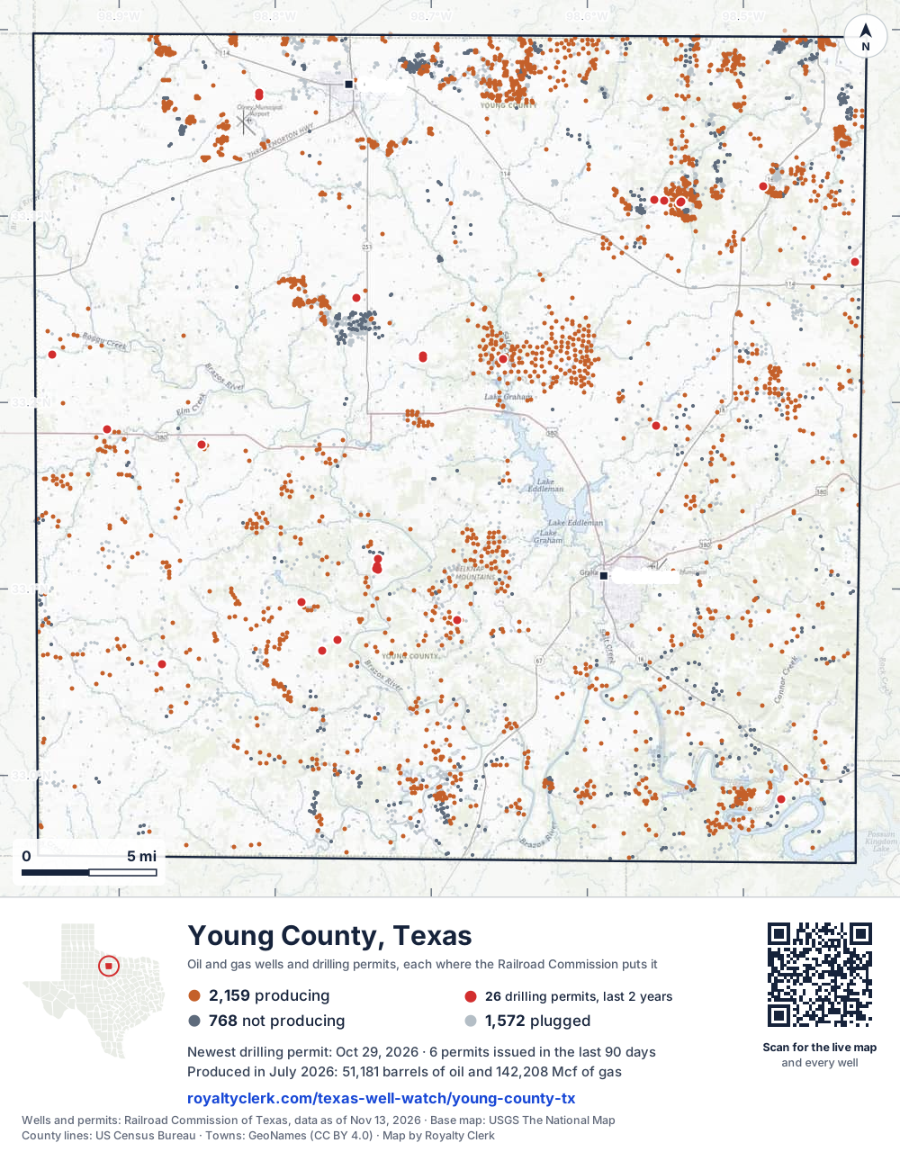
- Drilling locations26Permits issued in the last two years
- Producing wells2,159On a lease reporting production now
- Not producing768Shut in, inactive or no lease on record
- Plugged1,572The state's wellbore record says plugged
Sources: Railroad Commission of Texas well layers and permit files, US Census Bureau county outline, town points from GeoNames (CC BY 4.0), base map from USGS The National Map. A dot is a surface location; a horizontal well runs a mile or more from it.
4,499 wells with a location on the state's map and 26 drilling locations permitted in the last 24 months, each where the Railroad Commission puts it.
A permit is not a well.
Wells near each town in Young County
Wells within 10 miles of each town, on either side of the county line.
Use this map on your site
You may show this map on any site, unchanged. Keep the credit line and its link to Royalty Clerk under the map. The picture updates by itself as the state records new wells and permits.
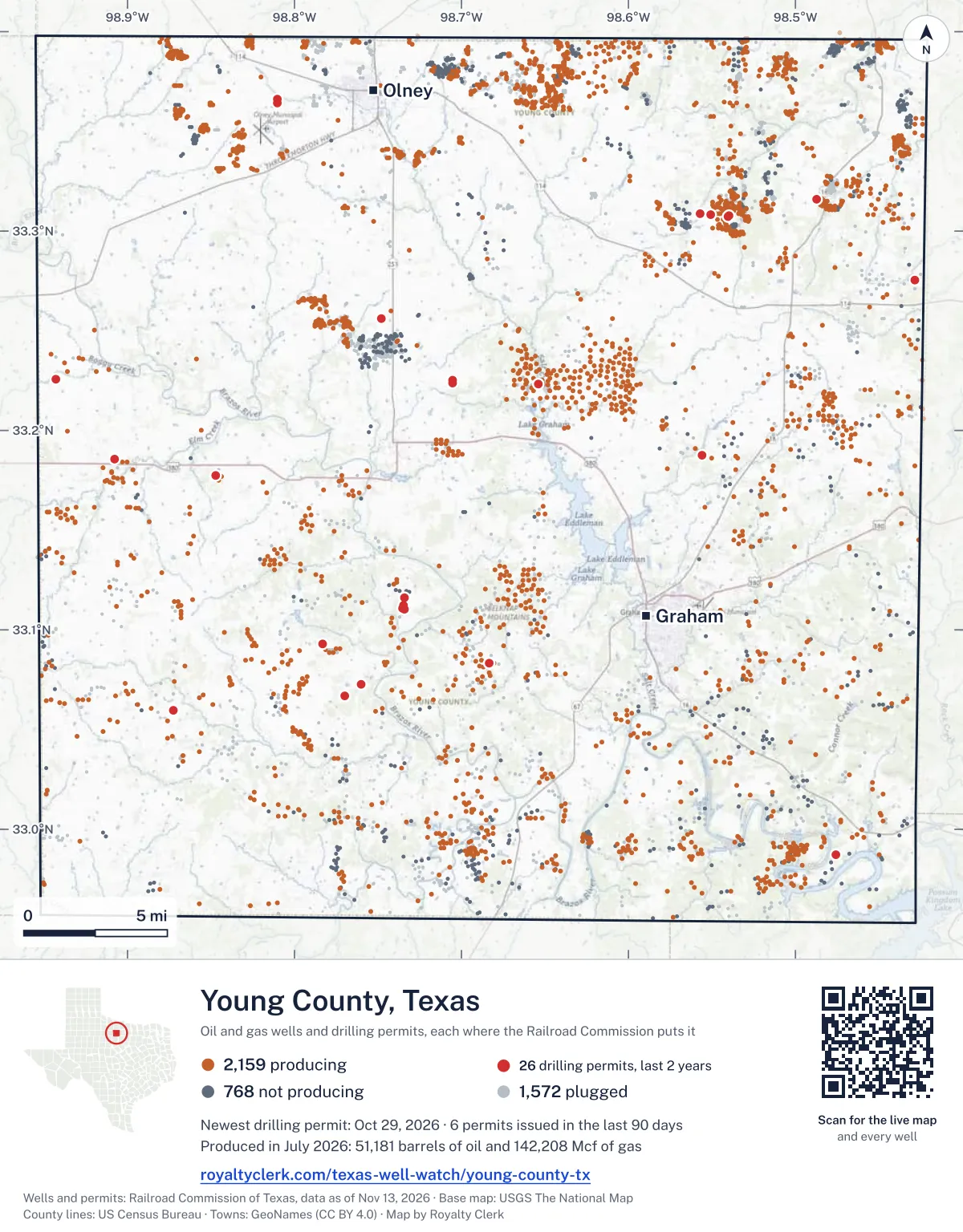
<a href="https://royaltyclerk.com/texas-well-watch/young-county-tx"><img src="https://royaltyclerk.com/maps/county-wells/young-county-tx.svg" alt="Map of Young County, Texas, with 4,499 oil and gas wells and 26 recent drilling locations as dots." width="1000" height="1280" loading="lazy" style="max-width:100%;height:auto;border:0"></a>
<p style="margin:4px 0 0;font-size:14px">Map: <a href="https://royaltyclerk.com/texas-well-watch/young-county-tx">Young County, Texas oil and gas wells</a> by Royalty Clerk, from Railroad Commission of Texas records</p>
The last twelve months
Month by month in Young County
| Month | Permits | Completions | First production |
|---|---|---|---|
| Oct 2026 | 2 | 0 | 0 |
| Sep 2026 | 2 | 0 | 0 |
| Aug 2026 | 3 | 0 | 0 |
| Jul 2026 | 4 | 0 | 0 |
| Jun 2026 | 1 | 1 | 0 |
| May 2026 | 1 | 0 | 0 |
| Apr 2026 | 1 | 0 | 0 |
| Mar 2026 | 0 | 1 | 0 |
| Feb 2026 | 1 | 1 | 0 |
| Jan 2026 | 1 | 0 | 1 |
| Dec 2025 | 1 | 0 | 0 |
| Nov 2025 | 0 | 1 | 0 |
Counted from November 16, 2025 to October 29, 2026, so the first and last months are partial. Source: Railroad Commission of Texas data sets.
Free, no sign-in
The newest drilling permits in Young County
| Issued | Lease and well | Operator | Drilling began | Depth, ft | API number | Coordinates | Permit |
|---|---|---|---|---|---|---|---|
| 2026-10-29 | DAWS 759 1new drill · verticalKeating Energy, Inc.API 42-503-42595 · permit 091959833.18584, -98.907714,999 ft | Keating Energy, Inc. | |||||
| 2026-10-28 | S HUGHES UNIT 8new drill · verticalRuthson Energy, Inc.API 42-503-42594 · permit 091967833.11101, -98.735566,500 ft | Ruthson Energy, Inc. | |||||
| 2026-09-21 | MCKINLEY 112new drill · verticalTomsha LLCAPI 42-503-42593 · permit 091860233.30784, -98.53978drilling began 2026-09-22 · 650 ft | Tomsha LLC | |||||
| 2026-09-14 | MCKINLEY 111new drill · verticalTomsha LLCAPI 42-503-42592 · permit 091860133.30718, -98.54011drilling began 2026-09-21 · 600 ft | Tomsha LLC | |||||
| 2026-08-24 | LOVING RANCH 11new drill · verticalBorderline Operating Corp.API 42-503-42591 · permit 091800033.27538, -98.428685,200 ft | Borderline Operating Corp. | |||||
| 2026-08-24 | S HUGHES UNIT 7new drill · verticalRuthson Energy, Inc.API 42-503-42590 · permit 091792533.11041, -98.734086,500 ft | Ruthson Energy, Inc. | |||||
| 2026-08-04 | BULLOCK 280 2Snew drill · verticalB.o.l.d. Oil and Gas, LLCAPI 42-503-42589 · permit 091751833.22385, -98.705213,500 ft | B.o.l.d. Oil and Gas, LLC | |||||
| 2026-07-31 | C.R. PERRY 2Rnew drill · verticalB.o.l.d. Oil and Gas, LLCAPI 42-503-42588 · permit 091748933.22588, -98.942921,200 ft | B.o.l.d. Oil and Gas, LLC | |||||
| 2026-07-24 | SECTION 606 'A' 15recompletion · verticalRidge Oil CompanyAPI 42-503-42403 · permit 091725533.22352, -98.65412drilling began 2026-06-10 · 4,580 ft | Ridge Oil Company | |||||
| 2026-07-17 | MCCLURG, M. L. 18new drill · verticalMammoth Operating LLCAPI 42-503-42587 · permit 091718633.31589, -98.48723600 ft | Mammoth Operating LLC | |||||
| 2026-07-15 | S. R. DOZIER 1new drill · verticalRogers Drilling Co., Inc.API 42-503-42586 · permit 091701933.05945, -98.872284,600 ft | Rogers Drilling Co., Inc. | |||||
| 2026-06-22 | SLATER UNIT 2re-entry · verticalBorderline Operating Corp.API 42-503-05158 · permit 091659033.18757, -98.55576drilling began 2026-08-21 · 3,999 ft | Borderline Operating Corp. | |||||
| 2026-05-20 | PETTUS 2re-entry · verticalKornye-Tillman CompanyAPI 42-503-38994 · permit 091540433.07260, -98.759984,630 ft | Kornye-Tillman Company | |||||
| 2026-04-27 | DUKE 1new drill · verticalB.o.l.d. Oil and Gas, LLCAPI 42-503-42585 · permit 091513233.25628, -98.747874,999 ft | B.o.l.d. Oil and Gas, LLC | |||||
| 2026-02-24 | S HUGHES UNIT 6new drill · verticalRuthson Energy, Inc.API 42-503-42584 · permit 091329733.11233, -98.73496drilling began 2026-02-25 · 6,500 ft | Ruthson Energy, Inc. | |||||
| 2026-01-07 | LUPTON UNIT 41recompletion · verticalCooper Oil & Gas, LLCAPI 42-503-42565 · permit 091112133.08320, -98.683314,900 ft | Cooper Oil & Gas, LLC | |||||
| 2025-12-17 | DEADMAN 1new drill · verticalStovall Operating Co.API 42-503-42583 · permit 091219333.06693, -98.76985drilling began 2026-01-21 · 4,999 ft | Stovall Operating Co. | |||||
| 2025-10-30 | STRAWN SAND 2new drill · verticalCraaybeek's Pro Energy, L.L.C.API 42-503-42582 · permit 091146033.36442, -98.810273,000 ft | Craaybeek's Pro Energy, L.L.C. | |||||
| 2025-10-29 | STRAWN SAND 1new drill · verticalCraaybeek's Pro Energy, L.L.C.API 42-503-42580 · permit 091136033.36626, -98.810023,000 ft | Craaybeek's Pro Energy, L.L.C. | |||||
| 2025-10-28 | HUGHES 5new drill · verticalRuthson Energy, Inc.API 42-503-42581 · permit 091138333.11592, -98.73405drilling began 2025-11-06 · 5,200 ft | Ruthson Energy, Inc. | |||||
| 2025-10-09 | STROTHER 5new drill · verticalBorderline Operating Corp.API 42-503-42579 · permit 091097233.17753, -98.84700drilling began 2025-11-03 · 4,999 ft | Borderline Operating Corp. | |||||
| 2025-08-12 | MOREN DEEP 2recompletion · verticalB.o.l.d. Oil and Gas, LLCAPI 42-503-42561 · permit 090977832.98718, -98.47595drilling began 2025-07-25 · 4,999 ft | B.o.l.d. Oil and Gas, LLC | |||||
| 2025-03-26 | BULLOCK 280 1Snew drill · verticalB.o.l.d. Oil and Gas, LLCAPI 42-503-42578 · permit 090689333.22522, -98.70523drilling began 2025-05-09 · 3,500 ft | B.o.l.d. Oil and Gas, LLC | |||||
| 2025-03-13 | GRAHAM VICK 1new drill · verticalGannett Operating LLCAPI 42-503-42577 · permit 090649433.09278, -98.78309drilling began 2025-05-14 · 5,000 ft | Gannett Operating LLC | |||||
| 2025-03-03 | SWEET 11new drill · verticalRunning WP Oil, LLCAPI 42-503-42576 · permit 090589133.30880, -98.55733drilling began 2025-11-06 · 1,000 ft | Running WP Oil, LLC | |||||
| 2025-02-27 | SWEET 10new drill · verticalRunning WP Oil, LLCAPI 42-503-42575 · permit 090588833.30835, -98.55093drilling began 2025-11-05 · 1,000 ft | Running WP Oil, LLC | |||||
| 2024-10-24 | P-MAC 5re-entry · verticalRogers Drilling Co., Inc.API 42-503-82538 · permit 090350833.38429, -98.50018drilling began 2024-10-31 · 3,700 ft | Rogers Drilling Co., Inc. | |||||
| 2024-10-18 | KENDALL 3Anew drill · verticalBoss Operating LLCAPI 42-503-42574 · permit 090328833.01071, -98.80402drilling began 2024-10-23 · 4,300 ft | Boss Operating LLC | |||||
| 2024-10-11 | LOVING RANCH 7recompletion · verticalBorderline Operating Corp.API 42-503-41132 · permit 090318833.28322, -98.43172drilling began 2002-02-12 · 5,198 ft | Borderline Operating Corp. | |||||
| 2024-10-07 | CARMACK 'B' 1new drill · verticalG. A. Hawkins Operating, LLCAPI 42-503-42573 · permit 090309033.06801, -98.89956drilling began 2024-11-21 · 5,000 ft | G. A. Hawkins Operating, LLC | |||||
| 2024-09-26 | MAY-PET 1new drill · verticalRogers Drilling Co., Inc.API 42-503-42572 · permit 090284233.05419, -98.87608drilling began 2024-11-07 · 4,600 ft | Rogers Drilling Co., Inc. | |||||
| 2024-08-27 | KENDALL 2Anew drill · verticalBoss Operating LLCAPI 42-503-42571 · permit 090219833.00948, -98.80295drilling began 2024-10-03 · 4,900 ft | Boss Operating LLC | |||||
| 2024-08-20 | RANCH 1recompletion · verticalRay Herring Operating Co., LLCAPI 42-503-40600 · permit 090206433.26816, -98.445474,450 ft | Ray Herring Operating Co., LLC | |||||
| 2024-06-06 | PERKINS-PROTHRO 1new drill · verticalGannett Operating LLCAPI 42-503-42570 · permit 090017233.06760, -98.88317drilling began 2024-06-28 · 5,000 ft | Gannett Operating LLC | |||||
| 2024-05-21 | GRAHAM WILLIAMS 1recompletion · verticalB.o.l.d. Oil and Gas, LLCAPI 42-503-42545 · permit 089973232.98457, -98.515754,223 ft | B.o.l.d. Oil and Gas, LLC | |||||
| 2024-05-16 | GRAHAM EST 2930 UNIT 1new drill · verticalStovall Operating Co.API 42-503-42569 · permit 089973133.12447, -98.83124drilling began 2024-09-10 · 4,999 ft | Stovall Operating Co. | |||||
| 2024-04-11 | MARSHALL 9new drill · verticalWalsh & Watts, Inc.API 42-503-42567 · permit 089821733.15518, -98.93584drilling began 2024-04-18 · 4,400 ft | Walsh & Watts, Inc. | |||||
| 2024-03-26 | PETTUS 1new drill · verticalKornye-Tillman CompanyAPI 42-503-42568 · permit 089835333.07343, -98.75999drilling began 2024-04-08 · 3,000 ft | Kornye-Tillman Company | |||||
| 2024-03-18 | MARSHALL 8new drill · verticalWalsh & Watts, Inc.API 42-503-42566 · permit 089821033.16148, -98.93060drilling began 2024-05-03 · 4,400 ft | Walsh & Watts, Inc. | |||||
| 2023-12-19 | CHRISTIE 1new drill · verticalGannett Operating LLCAPI 42-503-42565 · permit 089603233.08320, -98.68331drilling began 2024-01-18 · 4,900 ft | Gannett Operating LLC | |||||
| 2023-12-18 | HARRISON 5new drill · verticalS.b. Street Operating, Inc.API 42-503-42564 · permit 089597132.99307, -98.70651drilling began 2024-01-02 · 2,000 ft | S.b. Street Operating, Inc. | |||||
| 2023-12-18 | GRAHAM-HARRISON 10new drill · verticalStovall Operating Co.API 42-503-42563 · permit 089555232.99066, -98.71212drilling began 2023-12-19 · 1,999 ft | Stovall Operating Co. | |||||
| 2023-11-03 | MARSHALL -B- 25new drill · verticalJust Oil & Gas, Inc.API 42-503-42562 · permit 089501333.37928, -98.675551,000 ft | Just Oil & Gas, Inc. | |||||
| 2023-10-09 | KENDALL 1recompletion · verticalBoss Operating LLCAPI 42-503-32419 · permit 089427833.01229, -98.80944drilling began 2023-04-06 · 4,575 ft | Boss Operating LLC | |||||
| 2023-09-25 | MOREN DEEP 2new drill · verticalB.o.l.d. Oil and Gas, LLCAPI 42-503-42561 · permit 089399332.98718, -98.47595drilling began 2023-10-05 · 4,999 ft | B.o.l.d. Oil and Gas, LLC | |||||
| 2023-05-15 | GRAHAM WILLIAMS 1new drill · verticalB.o.l.d. Oil and Gas, LLCAPI 42-503-42545 · permit 089043632.98457, -98.51575drilling began 2023-09-26 · 4,999 ft | B.o.l.d. Oil and Gas, LLC | |||||
| 2022-06-14 | INGLISH UNIT 1new drill · verticalGannett Operating LLCAPI 42-503-42529 · permit 088090033.09076, -98.69751drilling began 2022-12-01 · 5,000 ft | Gannett Operating LLC | |||||
| 2022-06-10 | W. A. RIBBLE 15recompletion · verticalWells Oilfield Services, Inc.API 42-503-42530 · permit 088083732.97105, -98.49647drilling began 2023-10-17 · 3,085 ft | Wells Oilfield Services, Inc. |
A permit is permission to drill, not a well. Source: Railroad Commission of Texas drilling permit files.
Year by year
Drilling permits issued in Young County, by year
| Year | Permits issued |
|---|---|
| 2026 so far | 16 |
| 2025 | 10 |
| 2024 | 13 |
| 2023 | 7 |
| 2022 | 2 |
Counted from the permit files we hold, which start in 2022; that first year may be partial. Source: Railroad Commission of Texas drilling permit files.
The latest
The most recent records
| Date | What, who and where |
|---|---|
| 2026-10-29 | Permit issued: Keating Energy, Inc.DAWS 759 · A-764 · permit 0919598 |
| 2026-10-28 | Permit issued: Ruthson Energy, Inc.S HUGHES UNIT · A-1326 · permit 0919678 |
| 2026-09-21 | Permit issued: Tomsha LLCMCKINLEY · A-915 · permit 0918602 |
| 2026-09-14 | Permit issued: Tomsha LLCMCKINLEY · A-915 · permit 0918601 |
| 2026-08-24 | Permit issued: Borderline Operating Corp.LOVING RANCH · A-2056 · permit 0918000 |
| 2026-08-24 | Permit issued: Ruthson Energy, Inc.S HUGHES UNIT · A-1326 · permit 0917925 |
| 2026-08-04 | Permit issued: B.o.l.d. Oil and Gas, LLCBULLOCK 280 · A-527 · permit 0917518 |
| 2026-07-31 | Permit issued: B.o.l.d. Oil and Gas, LLCC.R. PERRY · A-820 · permit 0917489 |
| 2026-07-24 | Permit issued: Ridge Oil CompanySECTION 606 'A' · A-697 · permit 0917255 |
| 2026-07-17 | Permit issued: Mammoth Operating LLCMCCLURG, M. L. · A-274 · permit 0917186 |
| 2026-07-15 | Permit issued: Rogers Drilling Co., Inc.S. R. DOZIER · A-1285 · permit 0917019 |
| 2026-06-22 | Permit issued: Borderline Operating Corp.SLATER UNIT · A-157 · permit 0916590 |
| 2026-06-18 | Completed: Ridge Oil CompanySECTION 606 'A' · A-697 · permit 0917255 |
| 2026-05-20 | Permit issued: Kornye-Tillman CompanyPETTUS · A-1230 · permit 0915404 |
| 2026-04-27 | Permit issued: B.o.l.d. Oil and Gas, LLCDUKE · A-1078 · permit 0915132 |
Follow it
Watch Young County, or one abstract
What do you want to follow?
Where the land is. Your deed or lease names it.
For example A-1119, or Bush, or T&P 38. Your deed or the tax bill has it.
Other counties
Drilling activity in other counties
Related
Related
- ToolTexas well watchPermit, completion, first production and when the first check is due.
- ToolIs this buyout offer fair?The offer as months of your income, what the acres mean, and the questions to ask.
- ToolIs this lease offer good?Bonus and royalty against the county, and a scan of the lease's clauses.
- Texas dataTexas operator changesWho took over whose leases in the last 24 months.
- ToolLate payment interestDeadlines and the interest a late payment earns.
- Texas dataTexas oil and gas atlas254 counties, every lease, operator and field.
FAQ
Questions people ask
How many wells were permitted in Young County in the last year?
The Railroad Commission issued 17 drilling permits in Young County in the twelve months to October 29, 2026, and recorded 4 completions and 1 first-production report. A permit is permission to drill, not a well.
How do I get an alert when a permit is issued near my land in Young County?
Choose your abstract on this page, or the whole county, and sign in. You get one email a week, only when something new is recorded after you sign up. The alert says whether an event is on an interest in your Mineral File, on a place you follow, or only nearby.
When is my first royalty check due after a new well?
Natural Resources Code section 91.402(a) says on or before 120 days after the end of the month of first sale of production from the well. The state's first-production month is the closest public marker, so the date on this page is the earliest, not a certainty.
Got a new well on your land?
The first check is due within 120 days after the end of the month of first sale.
Sources
Primary sources, opened on 29 September 2026. Statute text is the current version on statutes.capitol.texas.gov.