
RRC field 34733610 · District 03
Giddings (Eagleford)
The Giddings (Eagleford) field reported 8.5 million barrels of oil and 4.7 million mcf of gas in the last 12 months.
Field dossier
- Producing leases
- 372of 392 on record
- Operators
- 13
- Counties
- 9
- Biggest operator
- Wildfire Energy Operating LLC
Own minerals in this field?
A family member owned minerals here?
Search their name: a family member who owned minerals hereWhere the field sits
fewermore
- Gas, last 12 months
- 4,650,968 mcf
- Data through
- Jul 2026
Wells in the Giddings (Eagleford) field

- Drilling locations50Permits issued in the last two years
- Producing wells503On a lease reporting production now
- Not producing14Shut in, inactive or no lease on record
- Plugged7The state's wellbore record says plugged
Each dot is a well on a lease the Railroad Commission lists in the Giddings (Eagleford) field, where its map puts it, or a drilling permit filed for the field in the last 24 months. Wells of other fields are not on this map. The picture is about 112 miles across. The white counties are the ones with a well or drilling permit of the field on the map. Sources: Railroad Commission of Texas well layers and drilling permit files, US Census Bureau county outlines, town points from GeoNames (CC BY 4.0).
Use this map on your site
You may show this map on any site, unchanged. Keep the credit line and its link to Royalty Clerk under the map. The picture updates by itself as the state records new wells and permits.
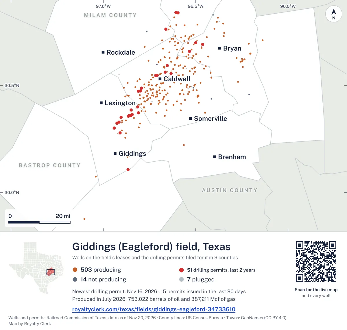
<a href="https://royaltyclerk.com/texas/fields/giddings-eagleford-34733610"><img src="https://royaltyclerk.com/maps/field-wells/giddings-eagleford-34733610.svg" alt="Map of the wells of the Giddings (Eagleford) field, Texas: 524 wells and 50 recent drilling locations, in a picture about 112 miles across." width="1000" height="951" loading="lazy" style="max-width:100%;height:auto;border:0"></a>
<p style="margin:4px 0 0;font-size:14px">Map: <a href="https://royaltyclerk.com/texas/fields/giddings-eagleford-34733610">Oil and gas wells of the Giddings (Eagleford) field, Texas</a> by Royalty Clerk, from Railroad Commission of Texas records</p>
How Giddings (Eagleford) grew, and who runs it now
Giddings (Eagleford) is a field of 392 leases in nine Texas counties, and 98.4% of its wells on producing leases are horizontal. In 2008, 22 leases reported here. The count grew through the 2010s, when Wildhorse Resources Mngt Co, LLC, Chesapeake Operating, L.L.C. and Williams, Clayton Energy, Inc. first reported 87, 75 and 40 leases. Since 2020, 85 more leases have started reporting, and 57 of them are run by Wildfire Energy Operating LLC. Wildfire Energy Operating LLC now runs 68.6% of the field's output, and Sage Natural Resources LLC runs 25.7%. Oil made more of the output than gas in every full calendar year from 2008 to 2025. Operators filed 38 drilling permits in the last 12 months, all for horizontal wells.
Not a forecast, not reserves.
Key moments
- 200822 leases report oil and gas in this field.
- 2013Leases reporting reach 50; oil reaches 913,233 bbl.
- 2015Leases reporting reach 121; oil reaches 3,997,661 bbl.
- 2018Leases reporting reach 239; oil reaches 10,524,848 bbl.
- 2020Biggest full calendar year: 15,687,908 bbl oil, 9,384,172 mcf gas.
- 2021Oil falls to 11,120,321 bbl; 331 leases report.
If you own here
- Find the land on my deed
Burleson County has 251 producing leases in this field. Finds a section, block or abstract number on a survey map.
- Royalty calculator
Wildfire Energy Operating LLC runs 68.6% of this field's output. Estimates a check from volume, price and decimal.
Questions owners ask
- Who runs the leases in this field now?
- Wildfire Energy Operating LLC runs 319 producing leases here and 68.6% of the field's output. Sage Natural Resources LLC runs 13 producing leases and 25.7% of the output. Magnolia Oil & Gas Operating LLC runs 17 producing leases and 3.9%.
- How many leases here are new since 2020, and who runs them?
- 85 leases first reported from 2020 on. Wildfire Energy Operating LLC runs 57 of those leases, Sage Natural Resources LLC runs 13 and Magnolia Oil & Gas Operating LLC runs 10.
- Why do so many wells in this field show as horizontal?
- 504 of the 512 wells on producing leases are horizontal. Operators also filed 38 drilling permits in the last 12 months, and all 38 were for horizontal wells.
- How old is the oldest producing lease in this field?
- M S Kavanaugh Unit, lease number 25135, first reported in March 2008. Wildfire Energy Operating LLC is its operator in the state records.
Related pages
- Wildfire Energy Operating LLC
Runs 319 producing leases and 68.6% of this field's output.
- Sage Natural Resources LLC
Runs 13 producing leases and 25.7% of this field's output.
- Magnolia Oil & Gas Operating LLC
Runs 17 producing leases here and reported 10 leases new since 2020.
- Burleson County
Holds 251 producing leases in this field, the largest county share listed.
- M S Kavanaugh Unit
The oldest producing lease in this field, first reported March 2008.
From the state's records through July 2026.
How much oil and gas has this field made each year?
Oil output in the Giddings (Eagleford) field rose 17% over the last 12 months
8.5M bbl through Jul 2026, against 7.3M bbl a year earlier. Peak Aug 2021: 859k bbl.
Gas output in the Giddings (Eagleford) field rose 5% over the last 12 months
4.7M mcf through Jul 2026, against 4.4M mcf a year earlier. Peak Aug 2021: 575k mcf.
SourceTexas Railroad Commission Production Data Query, field 34733610, through Jul 2026, file dated Oct 20, 2026.
Which leases are in this field, and how old are they?
Under each volume: change on the year before.
416,425bbl oiln/a
384,697bbl oiln/a
258,874bbl oiln/a
241,523bbl oil−39%
215,690bbl oiln/a
170,389bbl oiln/a
142,236bbl oiln/a
136,432bbl oiln/a
122,855bbl oiln/a
116,193bbl oiln/a
108,388bbl oil−39%
102,508bbl oiln/a
93,036bbl oiln/a
89,981bbl oiln/a
83,385bbl oiln/a
80,180bbl oiln/a
76,927bbl oil−37%
74,810bbl oil−33%
72,868bbl oiln/a
70,413bbl oil−15%
67,889bbl oiln/a
65,313bbl oiln/a
64,069bbl oiln/a
61,474bbl oiln/a
60,580bbl oil−15%
Showing 25 of 150 (the 150 largest of 372), ranked by output value.
SourceTexas Railroad Commission Production Data Query.
Who operates this field, and in which counties?
Operators, by oil
Wildfire Energy Operating leads
- Wildfire Energy Operating LLC319 leases5.8Mbbl
- Sage Natural Resources LLC13 leases2.3Mbbl
- Magnolia Oil & Gas Operating LLC17 leases331kbbl
- Trailblazer Energy Resources,llc4 leases56.2kbbl
- Atlas Operating LLC7 leases32.7kbbl
- BBL Operating Company LLC2 leases28.3kbbl
- Paleo Oil Company LLC2 leases9,973bbl
- Goldking Minerals Mgmt, L.L.C.1 lease9,808bbl
Counties, by oil
Burleson County leads
More operators
More counties
What drilling permits have been filed here recently?
HUNTER EF THREE #H 03GH
new drill · horizontal · Magnolia Oil & Gas Operating LLC · Brazos County
Permit 0919984 · Nov 13, 2026
CHARLOTTE NICOLE A #1HE
new drill · horizontal · Magnolia Oil & Gas Operating LLC · Burleson County
Permit 0919369 · Oct 22, 2026
STEFKA EF UNIT #H 01SM
new drill · horizontal · Magnolia Oil & Gas Operating LLC · Burleson County
Permit 0919271 · Oct 20, 2026
PEDRO EAST EF #1H
new drill · horizontal · Sage Natural Resources LLC · Lee County
Permit 0919028 · Oct 19, 2026
MUTT EF UNIT #H 05SM
new drill · horizontal · Magnolia Oil & Gas Operating LLC · Burleson County
Permit 0919275 · Oct 15, 2026
KELLY EF UNIT #H 03SM
new drill · horizontal · Magnolia Oil & Gas Operating LLC · Burleson County
Permit 0919276 · Oct 15, 2026