
Texas oil lease
ProducingHAMILTON
Hamilton is an oil lease in Live Oak County, Texas, operated by Marathon Oil Ef LLC in the Eagleville (Eagle Ford-2) field.
4 wells
- Operator
- Marathon Oil Ef LLC
- County
- Live Oak County
- RRC lease
- 02-10697
4 royalty accounts on the county roll
Is your family on this lease?
Where it sits
This county
- Gas, last 12 months
- 20,604 mcf
- Oil in Aug 2026
- 839 bbl
Did a relative own a share of this lease?
Pick the year they passed and see what the lease has sold since.
Wells on this lease and around it
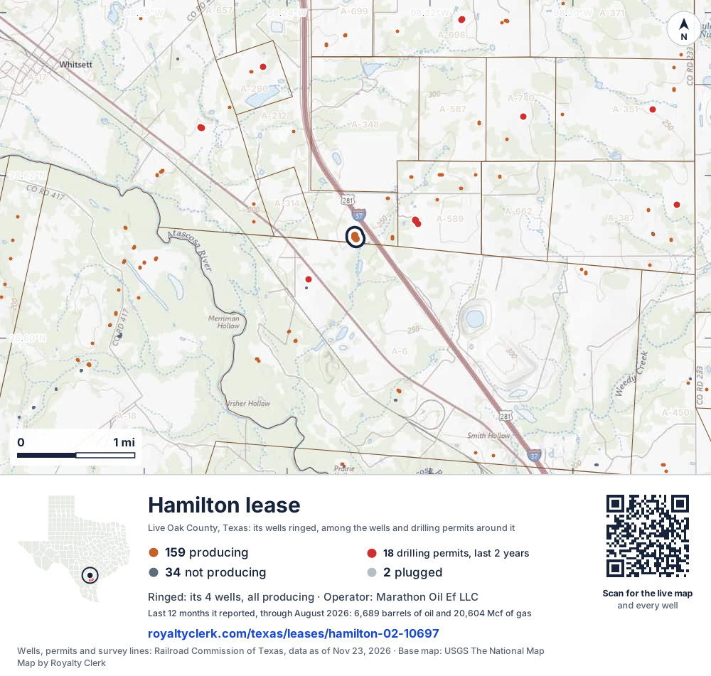
- This lease4Its wells, ringed on the map: all producing
- Drilling locations18Permits issued in the last two years
- Producing wells159On a lease reporting production now
- Not producing34Shut in, inactive or no lease on record
- Plugged2The state's wellbore record says plugged
The 4 ringed dots are this lease's wells, each where the Railroad Commission's map puts it. The other dots are wells and drilling permits of the last 24 months on the land around it; the counts are for everything in the picture, which is about 6 miles across. The thin brown lines are the original land surveys; where there is room, a survey carries its abstract number, the number deeds and division orders cite. Sources: Railroad Commission of Texas well layers, drilling permit files and survey lines, base map from USGS The National Map.
A one-page map of this lease to print, for a lawyer, a buyer or a probate file.
Use this map on your site
You may show this map on any site, unchanged. Keep the credit line and its link to Royalty Clerk under the map. The picture updates by itself as the state records new wells and permits.
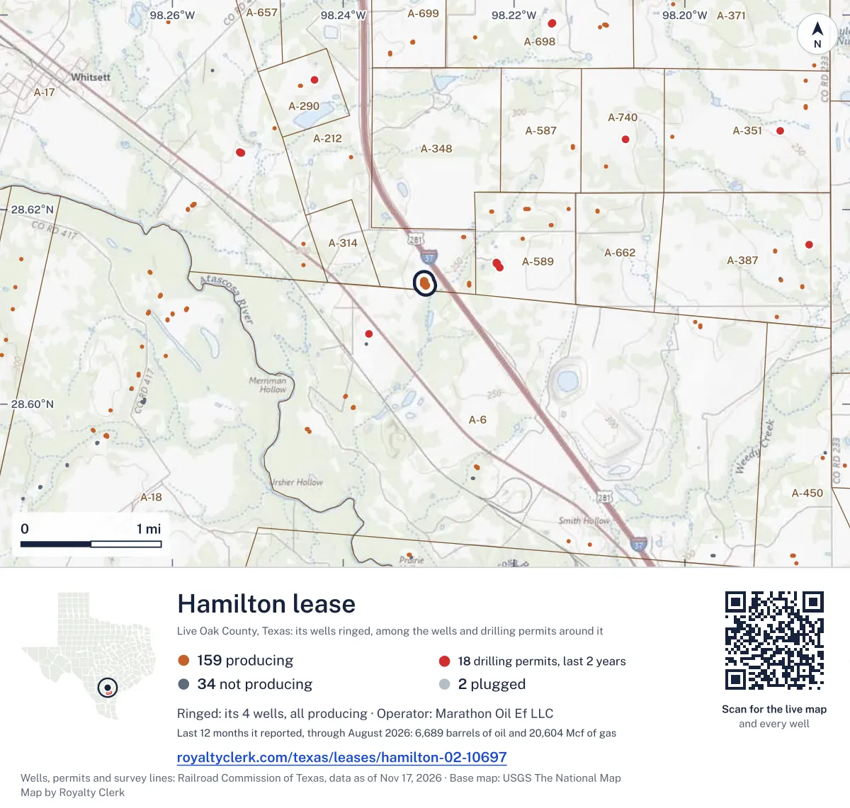
<a href="https://royaltyclerk.com/texas/leases/hamilton-02-10697"><img src="https://royaltyclerk.com/maps/lease-wells/hamilton-02-10697.svg" alt="Map of the Hamilton lease in Live Oak County, Texas: its 4 wells ringed, among 195 wells and 18 recent drilling locations in a picture about 6 miles across." width="1000" height="951" loading="lazy" style="max-width:100%;height:auto;border:0"></a>
<p style="margin:4px 0 0;font-size:14px">Map: <a href="https://royaltyclerk.com/texas/leases/hamilton-02-10697">Wells on the Hamilton lease, Live Oak County, Texas</a> by Royalty Clerk, from Railroad Commission of Texas records</p>
Other leases named Hamilton
- 02-10697, oil leaseThis leaseProducing6,689 bbllast 12 reported months
- 02-285884, gas wellProducing8,878 mcflast 12 reported months
Production by month
Oil output rose 9% over the last 12 months
- Oil (bars)
- Gas (line)
- Last 12 months
SourceTexas Railroad Commission Production Data Query, through Aug 2026.
From the state record
What owners ask about Hamilton
- When is the check for August 2026 due?
- August 2026 is the newest month the state has posted for this lease. Texas law gives the payor until 60 days after the end of the sale month for oil and 90 for gas: the oil by Oct 30, 2026 and the gas by Nov 29, 2026, unless the lease sets another time.
- Source: Railroad Commission production reports; Texas Natural Resources Code §91.402.
- See your next three checks
- Which Texas production tax rate applies?
- The Texas Comptroller lists no approved exemption or reduced rate for this lease for August 2026, so the full 4.6% on oil and 7.5% on gas applies.
- Source: Texas Comptroller, approved severance tax exemptions.
- Check the tax on your stub
- Who buys the oil and gas?
- Oil: Statewide Crude Inc., Plains Pipeline L.p. and Reynolds Energy Transport LLC gather it. Gas from oil wells: Marathon Oil Ef LLC buys and gathers it. The buyer's price is what a royalty check is figured on.
- Source: Railroad Commission Form P-4, gatherers and purchasers.
- See every buyer and past buyers
- How many 1099s should an owner expect for 2025?
- One company, Marathon Oil Ef LLC, filed this lease's reports behind every 2025 check, so most owners get one form. The operator is not always the company that pays, so go by the name on the stubs.
- Source: Railroad Commission production reports, operator of record by month.
- Check your 1099 against it
Free tools, already on this lease
Ask a question about Hamilton
33 years of state records, 1993–2026
HAMILTON since 2013
We read every monthly report the Railroad Commission holds, back to January 1993. This lease first reported in November 2013. It filed 154 monthly reports through August 2026.
Sold since 2013
$41.1 million
What the whole lease’s oil and gas sold for at each month’s public prices, before tax and the operator’s deductions. A royalty owner’s share is their decimal of it.
- Oil sold
- 493,251 bbl
- Gas sold
- 1,180,899 mcf
- Best year
- 2014$18.7 million sold
- Last report
- Aug 2026First: Nov 2013
Its best year was 2014: $18.7 million of oil and gas sold
Each bar is what the lease’s oil and gas sold for that year, at that month’s prices. 2026 is only part of a year in the records, drawn lighter.
- Oil
- Gas
SourceTexas Railroad Commission Production Data Query, every monthly report since January 1993; EIA monthly WTI and Henry Hub prices (before 1997, EIA's yearly Texas natural gas wellhead price), through August 2026.
Every year as a table
| Year | Months | Oil sold, bbl | Gas sold, mcf | Sold for |
|---|---|---|---|---|
| 2026 * | 8 | 4,440 | 9,295 | $414,199 |
| 2025 | 12 | 6,727 | 6,388 | $459,407 |
| 2024 | 12 | 7,658 | 10,171 | $616,613 |
| 2023 | 12 | 8,170 | 7,069 | $650,390 |
| 2022 | 12 | 8,076 | 11,135 | $842,221 |
| 2021 | 12 | 13,341 | 20,014 | $970,176 |
| 2020 | 12 | 13,971 | 16,034 | $583,077 |
| 2019 | 12 | 20,906 | 38,262 | $1,285,961 |
| 2018 | 12 | 26,084 | 56,743 | $1,862,611 |
| 2017 | 12 | 33,522 | 80,147 | $1,947,361 |
| 2016 | 12 | 48,547 | 119,510 | $2,353,588 |
| 2015 | 12 | 65,414 | 201,376 | $3,753,559 |
| 2014 | 12 | 173,456 | 480,752 | $18,785,005 |
| 2013 | 2 | 62,939 | 124,003 | $6,645,362 |
* Part of the year: the records run through August 2026.
Where the gas went
Since Jun 2026 the lease's gas goes to a processing plant instead of lease fuel
Flaring peaked at 22.6% of the gas in Oct 2025.
- Processing plant (3)
- Lease fuel (1)
- Flared (4)
SourceTexas Railroad Commission Production Data Query, through Aug 2026.
Processing plant (3)
50% · 11,159 mcf
Lease fuel (1)
42% · 9,401 mcf
Flared (4)
8.2% · 1,831 mcf
8.2% of the gas flared in the last 12 months. 22 months above 3%.
4 wells on this lease
| API number | Well | Status | Completed |
|---|---|---|---|
| 42-297-35291 | Hamilton 4H | Shut in | Nov 11, 2013 |
| 42-297-35292 | Hamilton 1H | Active | Nov 6, 2013 |
| 42-297-35294 | Hamilton 2H | Active | Nov 5, 2013 |
| 42-297-35295 | Hamilton 3H | Active | Nov 11, 2013 |
SourceTexas Railroad Commission production records and full wellbore file.
Other leases on these wells
The Railroad Commission files the same API numbers under one more lease too: a well keeps its number when it moves into a unit or is recompleted under another lease. A deed older than the unit may name one of them.
- Hamilton, Live Oak County · 1 shared well
Buyers and gatherers
| Company | Product | Role | Share% | From | Until |
|---|---|---|---|---|---|
| Statewide Crude Inc. | Oil | Gathers | 50 | Jul 1, 2022 | – |
| Plains Pipeline L.p. | Oil | Gathers | 25 | Jul 1, 2022 | – |
| Reynolds Energy Transport LLC | Oil | Gathers | 25 | Jul 1, 2022 | – |
| Marathon Oil Ef LLC | Casinghead gas | Buys | 100 | Nov 6, 2013 | – |
| Marathon Oil Ef LLC | Casinghead gas | Gathers | 100 | Nov 6, 2013 | – |
| Gulfmark Energy, Inc. | Oil | Gathers | 10 | Nov 6, 2013 | Jul 1, 2022 |
| Statewide Crude Inc. | Oil | Gathers | 90 | Nov 6, 2013 | Jul 1, 2022 |
SourceRailroad Commission Form P-4 file, Oct 24, 2026 (source).
233 acres on the newest permit
- Worth asking
A Rule 37 case is listed
The RRC permit records list a Rule 37 case. This does not establish your royalty share. Ask for the permit and unit plat for your well.
| API number | Well no. | Permit issued | Completed | Acreson the permit |
|---|---|---|---|---|
| 42-297-35294 | 2H | Jan 18, 2013 | Nov 5, 2013 | 233 |
| 42-297-35295 | 3H | Jan 18, 2013 | Nov 11, 2013 | 233 |
| 42-297-35291 | 4H | Jan 11, 2013 | Nov 11, 2013 | 233 |
| 42-297-35292 | 1H | Jan 11, 2013 | Nov 6, 2013 | 233 |
What ConocoPhillips told investors it received
| Quarter | Oil$ per bbl | Gas$ per mcf | Gas liquids$ per bbl | Filing |
|---|---|---|---|---|
| Q3 2026 | $88.80 | $5.70 | $25.19 | SEC filing |
| Q2 2026 | $99.40 | $2.58 | $24.54 | SEC filing |
| Q1 2026 | $73.47 | $4.09 | $20.42 | SEC filing |
| Q3 2025 | $66.13 | $4.28 | $19.20 | SEC filing |
| Q2 2025 | $64.23 | $4.16 | $20.98 | SEC filing |
| Q1 2025 | $71.65 | $5.62 | $25.40 | SEC filing |
SourceConocoPhillips quarterly reports, SEC EDGAR, company-wide averages before hedging.
On the Live Oak County roll
Live Oak County Appraisal District
2026 roll- Owners
- 5
- Accounts
- 5
- Appraised in all
- $1.2M$1,171,330
Each square is one account
- Royalty4
- Working interest1
SourceLive Oak County Appraisal District, 2026 mineral roll (source), read Sep 29, 2026. Accounts matched to this lease by RRC number or lease name; no owner is named.
Estimate your royalty
36 months, newest first
| Month | Oil producedbbl | Oil soldbbl | Gas producedmcf | Gas soldmcf, codes 2+3 | Flaredmcf | WTI$/bbl | Henry Hub$/MMBtu |
|---|---|---|---|---|---|---|---|
| Aug 2026 | 839 | 838 | 2,889 | 2,295 | 86 | $83.90 | $2.78 |
| Jul 2026 | 1,030 | 1,035 | 4,128 | 3,305 | 166 | $80.46 | $2.89 |
| Jun 2026 | 624 | 845 | 1,805 | 1,305 | 94 | $84.81 | $3.15 |
| May 2026 | 582 | 493 | 1,966 | 796 | 111 | $102.13 | $2.94 |
| Apr 2026 | 514 | 508 | 1,117 | 466 | 72 | $100.32 | $2.77 |
| Mar 2026 | 608 | 524 | 1,498 | 952 | 80 | $91.38 | $3.04 |
| Feb 2026 | 0 | 0 | 0 | 0 | 0 | $64.51 | $3.62 |
| Jan 2026 | 197 | 197 | 629 | 176 | 48 | $60.04 | $7.72 |
| Dec 2025 | 573 | 596 | 1,840 | 508 | 109 | $57.97 | $4.26 |
| Nov 2025 | 1,032 | 1,014 | 1,795 | 702 | 82 | $60.06 | $3.79 |
| Oct 2025 | 283 | 285 | 999 | 256 | 226 | $60.89 | $3.19 |
| Sep 2025 | 407 | 423 | 1,938 | 72 | 423 | $63.96 | $2.97 |
| Aug 2025 | 558 | 551 | 1,787 | 326 | 334 | $64.86 | $2.91 |
| Jul 2025 | 638 | 628 | 1,738 | 343 | 378 | $68.39 | $3.20 |
| Jun 2025 | 680 | 681 | 1,657 | 629 | 119 | $68.17 | $3.02 |
| May 2025 | 659 | 650 | 2,505 | 907 | 21 | $62.17 | $3.12 |
| Apr 2025 | 603 | 589 | 2,660 | 914 | 40 | $63.54 | $3.42 |
| Mar 2025 | 575 | 557 | 2,786 | 919 | 153 | $68.24 | $4.12 |
| Feb 2025 | 309 | 323 | 1,032 | 371 | 40 | $71.53 | $4.19 |
| Jan 2025 | 439 | 430 | 1,219 | 441 | 23 | $75.74 | $4.13 |
| Dec 2024 | 414 | 408 | 1,103 | 475 | 28 | $70.12 | $3.01 |
| Nov 2024 | 295 | 310 | 1,244 | 469 | 100 | $69.95 | $2.12 |
| Oct 2024 | 460 | 458 | 1,490 | 587 | 67 | $71.99 | $2.20 |
| Sep 2024 | 497 | 518 | 1,834 | 888 | 48 | $70.24 | $2.28 |
| Aug 2024 | 756 | 744 | 2,020 | 1,100 | 28 | $76.68 | $1.99 |
| Jul 2024 | 590 | 646 | 2,367 | 1,191 | 39 | $81.80 | $2.07 |
| Jun 2024 | 797 | 729 | 2,612 | 1,360 | 47 | $79.77 | $2.54 |
| May 2024 | 873 | 877 | 2,269 | 1,337 | 39 | $80.02 | $2.12 |
| Apr 2024 | 856 | 850 | 1,952 | 1,125 | 39 | $85.35 | $1.60 |
| Mar 2024 | 772 | 765 | 1,519 | 880 | 12 | $81.28 | $1.49 |
| Feb 2024 | 687 | 711 | 1,621 | 495 | 85 | $77.25 | $1.72 |
| Jan 2024 | 637 | 642 | 1,698 | 264 | 254 | $74.15 | $3.18 |
| Dec 2023 | 554 | 522 | 2,367 | 8 | 230 | $71.90 | $2.52 |
| Nov 2023 | 447 | 467 | 1,369 | 175 | 135 | $77.69 | $2.71 |
| Oct 2023 | 659 | 668 | 2,223 | 31 | 100 | $85.64 | $2.98 |
| Sep 2023 | 718 | 708 | 2,289 | 38 | 50 | $89.43 | $2.64 |
Flared above 3%
SourceTexas Railroad Commission Production Data Query, through Aug 2026. Prices: EIA.
How to check your stub against this lease Checks stopped on this lease? See the likely reasonsNearby
This lease belongs to
Marathon Oil Ef LLC in Live Oak County
- MCCOY UNIT B
7,222 bbl
- SINOR RANCH 02
49,428 mcf
- FRANK MALEK 02
113,656 mcf
- HERSCHEL FULBRIGHT 01
25,037 mcf
- DAVID SAENZ 01
59,798 mcf
- SAN CHRISTOVAL RANCH UNIT C
82,274 mcf
- LIVE OAK PARTNERS 02
16,044 mcf
- NITSCH UNIT A-B PSA
86,723 mcf
- THREE SISTERS 01
33,568 mcf
- GUAJILLO UNIT 11 SOUTH
6,311 bbl
Eagleville (Eagle Ford-2) field
- SHIPMAN UNIT D
7,122 bbl
- GUERRA UNIT B
6,928 bbl
- JORDAN B
55,020 mcf
- MIGURA B - CASKEY B SA 4
87,262 mcf
- CREWS A-CEF 1H
7,482 bbl
- NICHOLS A UNIT
25,899 mcf
- POHLER A
5,608 bbl
- BREWER UNIT B
6,672 bbl
- 4J MINERAL BARNETT EAST PSA B
7,244 bbl
- SHARKTOOTH (SA) UNIT 2
17,894 mcf
Leases within 10 km
- MCCOY-HAMILTON UNIT
18,530 bbl · 0.5 km
- MCCOY-RAFTERS UNIT
12,670 bbl · 0.7 km
- RAFTER TWO UNIT E
270,522 bbl · 0.9 km
- RAFTER TWO C-E ULW E
111,596 bbl · 0.9 km
- RAFTER TWO UNIT C
113,171 bbl · 0.9 km
- LOPEZ UNIT
0 bbl · 0.9 km
- H. HARLAN BETHUNE 01
102,202 bbl · 1.4 km
- MCCOY-RAFTERS ALLOCATION
951 bbl · 1.5 km
- MCCOY UNIT A
3,448 bbl · 1.5 km
- JERRY HOUSE UNIT A
23,711 bbl · 1.6 km
Drilling permits within 10 km
PLOMERO-IVAS-TS USW D #4
new drill · horizontal · Burlington Resources O & G Co LP · Live Oak County · 8.2 km
Permit 0919925 · Nov 5, 2026
WHITSETT-TAYLOR-MASS SA C #1
new drill · horizontal · Marathon Oil Ef LLC · Live Oak County · 2.6 km
Permit 0918398 · Sep 21, 2026
WHITSETT-TAYLOR-MASS SA D #1
new drill · horizontal · Marathon Oil Ef LLC · Live Oak County · 2.6 km
Permit 0918399 · Sep 21, 2026
WHITSETT-TAYLOR-MASS SA B #1
new drill · horizontal · Marathon Oil Ef LLC · Live Oak County · 2.6 km
Permit 0918391 · Sep 21, 2026
WHITSETT-TAYLOR-MASS SA A #1
new drill · horizontal · Marathon Oil Ef LLC · Live Oak County · 2.6 km
Permit 0918390 · Sep 21, 2026