
Texas operatorRRC operator 028726Active
Arbol Resources, Inc.
Arbol runs 4 producing leases in Robertson County. They sold 34,738 mcf of gas in the last 12 months, through July 2026.
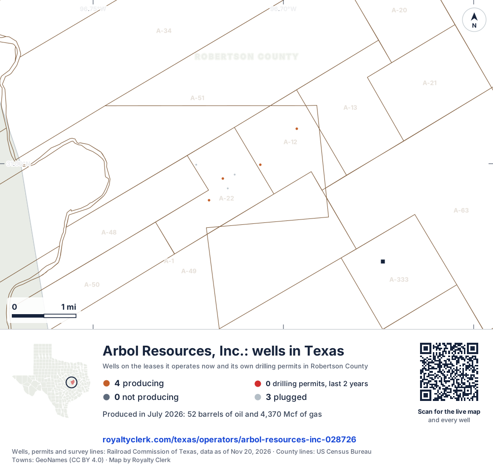
- Producing leases
- 4 of 6 on record
- Counties
- 1
- Biggest county
- Robertson
- Biggest field
- Milano, East (Buda)
- First report
- 1993 or before
- Newest month
- July 2026
The story, from 403 months of reports
How Arbol Resources runs its Robertson County leases
Arbol Resources, Inc. runs six leases, and four of them are producing. All of its production is in Robertson County, across two fields. Gas made more of its output than oil in every full calendar year from 2020 to 2025, counted in barrels of oil equivalent.
Its oil and gas fell together in the early years. Oil dropped from 1,103 bbl in 2020 to 608 bbl in 2023, and gas dropped to 26,217 mcf that year. Gas then rose to 42,083 mcf in 2024, and in 2025 it was 39,433 mcf.
All of its gas in the last 12 months went to a line. Arbol Resources, Inc. is a buyer on two of its leases, and Atmos Energy Marketing, LLC is a buyer on two others. The oldest producing lease, Burnitt, Pauline D., has reports back to January 1993.
Not a forecast, not reserves.
403 months against six other recordsNew
Every month since January 1993, and what else happened that month
All of its leases added together are the line on top. Under it, on the same clock: the weather, the price, how many leases it ran, takeovers, the State and its buyers. Move across it.
Oil averaged $17.99 a barrel · 2 leases reporting
- No public record explains this drop.
- No storm in its main counties, no State cut-off, no lease moving to or from it and no change of buyer on record that month. The price was less than 15% under three months before, and the leases reporting fell by less than a tenth.
Move the pointer or drag across the chart. The numbered buttons jump to each month.
Monthly production of all Arbol Resources, Inc. leases, with the records of the same months beneath it. 403 months from January 1993 to July 2026. The most in one month: 1,285 barrels, January 2003. The newest month: 52 barrels. 69 months with nothing reported. Moments marked: 1, Nov 1995; 2, Jun 1997; 3, Dec 1999; 4, Nov 2013; 5, Apr 2023.
SourcesProduction, leases, takeovers, cut-offs and buyers: Railroad Commission of Texas. Weather: NOAA. Prices: U.S. Energy Information Administration (West Texas Intermediate a barrel, Henry Hub per million Btu and, before 1997, the Texas wellhead's yearly average an mcf). Operator 028726, through July 2026, file dated Oct 20, 2026. A record in the same month is not proof of a cause.
Royalty Watch tells you the month your own lease starts to drop, with the records from that month.See Royalty Watch
Every producing lease, drawn to size
Which of its leases produce, biggest first
Each box is one lease. Its size is the gas it sold in the last 12 months. Its colour says whether that is more or less than the 12 months before. Tap a box to see the lease in the list.
| County | Field | mcf produced, 12 reports | on the 12 before | 24 months | Also on record | |
|---|---|---|---|---|---|---|
| Burnitt, Pauline D. | Robertson | Milano, East (Buda) | 20,308 | ▼ 8.28% | 2 silent months, 2023Lower tax | |
| Anderson | Robertson | Pecan Gap (5050) | 638bbl | ▲ 3.74% | Nothing else | |
| Burnitt, Pauline D. | Robertson | Milano, East (Buda) | 8,489 | ▼ 27.1% | 4 silent months, 2023Lower tax | |
| Cristina | Robertson | Milano, East (Buda) | 5,941 | ▼ 18.7% | 2 silent months, 2023Lower tax |
SourceTexas Railroad Commission Production Data Query, operator 028726, through July 2026. Two more leases are on record and not producing.
When leases change handsNew
6 leases changed hands. Five went quiet.
A new operator has to set up every owner again before it can pay. A lease that also stops reporting is the one to watch: many leases end after 60 to 90 days without production unless the lease says otherwise.
of the 6 leases taken over in December 1999 reported nothing for two months or more in the year after.
of the 6 never missed a month.
of the 2 leases taken over in May 1995 missed a month.
of its leases have stopped reporting. The last of them reported in April 2019, and none has reported since.
Reported nothing since
- Anderson, Sallie Jane Unitsince Mar 2012 · 173 months without a report
- Calvert Farmssince May 2019 · 87 months without a report
A gap in the State’s record is not a missed payment by itself. Wells are often worked on after a takeover. It is the month to check against your own stubs.
SourceRailroad Commission production reports and operator of record by month. A lease counts as taken over when the operator of record changes from one month to the next and the operator before it reported within the year.
Royalty Watch tells you the month your lease gets a new operator, and what to send them.See Royalty Watch
Prices and tax, July 2026New
The State approved a lower tax on 3 of its 4 leases
The market price is the public benchmark. The price on your statement is the one to set beside it, and the tax line beside the rate the State approved.
The State approved a lower tax on 3 of its 4 leases
- LOW PRODUCING WELLS
- 3 leases
- Newest approval
- October 2013
On those leases the tax line on a statement should show the lower rate. Each lease page says which wells and until when.
Check the tax on your stubSourcesMarket: U.S. Energy Information Administration, July 2026 (Henry Hub per million Btu). Tax approvals: Texas Comptroller. Leases sell at different points and qualities, so prices differ for ordinary reasons too. Comptroller tax approval source date unavailable.
Watch Plus sets these prices beside the price on each of your statements, every month.See Watch Plus
Who takes the oil and gasNew
Arbol Resources, Inc. takes 82.9% of its gas
The State lists who gathers and who buys from each lease. Company filings list who owns whom. Here they are on one drawing, for its 3 leases.
- Arbol Resources, Inc.82.9%2 leases
- Atmos Energy Marketing, LLC17.1%1 lease
No shared owner, officer or address on record between the gas buyers and the operator.
SourcesBuyers and gatherers: Railroad Commission Form P-4 records, weighted by each lease’s sales. Ownership: U.S. Securities and Exchange Commission filings and Railroad Commission P-5 records. Each buyer’s link is its own: a parent, officer or address shared by one buyer is never read onto another. Newest P-4 record effective July 27, 2021.
Royalty Watch tells you the day the buyer of your oil or gas changes.See Royalty Watch
Seen from space, 2025New
No repeat heat matched to this operator's leases in the records read
NOAA's VIIRS instruments record hot spots at night on the passes they make over Texas, when cloud does not hide the ground. In the readings read here for 2025, no spot that repeated near the located wells of Arbol's leases was matched to one of them. That is not a finding that its pads had no heat: a lease is looked at only where its wells have a location on file, and cloud and missed passes hide nights. A location alone does not show that the satellites saw its wells. No flaring report was matched at the leases included in the comparison for 2025. That is not a finding that it reported none: a lease with no well location on file is not compared, and a month with no report read is not counted.
lease-nights of repeat heat matched to Arbol's leases in the satellite records read for 2025: not proof of no heat, since only clear nights on the passes read are seen.
lease-month with flaring reported at the leases included in the comparison, January to December 2025. Not a count for the operator: a lease with no well location on file is not compared, and a month with no report read is not counted as a report.
Where the gas from all its leases went, Aug 2025 to Jul 2026, as Arbol reported it to the Railroad Commission
SourcesHeat: NOAA VIIRS night detections (375 m) within 500 m of a lease's located wells, counted only where the spot repeats on several nights; GOES-East readings never establish a night. Reported flaring and gas use: Railroad Commission production reports, by disposition code (what the codes mean). Cloud, missed passes and days missing from the readings hide nights, so a count of nights or lease-nights is a floor and no heat matched is not proof of none. The satellite records heat. It does not say what burned. Flaring set beside the heat (disposition code 4) is counted only at the leases included in the comparison, January to December 2025; a lease with no well location on file is not compared, and a month with no report read for a lease is not counted as a report. The gas use shares count all its leases, August 2025 to July 2026. Nights counted for January to December 2025; satellite readings read here run from February 22, 2024 through November 17, 2026. Production report file dated October 20, 2026.
Watch Plus checks whether you were paid on gas in the months heat was seen at your lease.See Watch Plus
Permits, drilling and fracsNew
Wells between permit and first production
The State's permit list, as read here, holds no drilling permit for Arbol. The dates its wells were drilled, fracked and first produced are not on file here, so this page cannot say whether a well is on the way.
SourcesPermits, drilling dates and completions: Railroad Commission of Texas. Frac dates: FracFocus chemical disclosure registry. Permit list dated November 18, 2026.
Royalty Watch tells you the day a well on your lease moves to its next stage.See Royalty Watch
On file with the Railroad Commission of Texas
Arbol Resources, Inc. address and phone number
- Organization
- Arbol Resources, Inc.
- Operator number
- 028726
- Status
- Active
- Mailing address
- 13501 Katy Fwy Ste 1485
Houston, TX 77079-1180 - Phone
- (713) 784-1675
- Last filing received
- Apr 1, 2026
- Leases on record
- 6, of which 4 producing
- First production report
- January 1993 or before
- Railroad Commission district
- 01
- Organization type
- Corporation
This is the address of record with the State. It can be a regulatory office and not the desk that pays royalties.
SourceRailroad Commission of Texas, organization (P-5) file. Record dated October 22, 2026. No address is shown for a person who operates under their own name. Royalty Clerk is not affiliated with Arbol Resources, Inc..
From the state record
What owners ask about Arbol
- 01Did Arbol take over my lease from another company?
- 2 leases6 leases1 leaseJan 1993Jul 2026
- The biggest takeovers: 2 from Janex Oil Co., Inc. in May 1995; 6 from Arrow Exploration Company in December 1999; 1 from Teamco Operating LLC in September 2002. Each lease page shows who ran the lease in every month back to January 1993.
- Source: Railroad Commission production reports, operator of record by month.
- See the five that went quiet
- 02When is the check for July 2026 due?
- Jul 31sale month endsSep 29oil dueOct 29gas dueTODAY, NOV 20
- July 2026 is the newest month the State has posted for Arbol's leases. Texas law gives the payor until 60 days after the end of the sale month for oil and 90 for gas: the oil by September 29, 2026 and the gas by October 29, 2026, unless the lease sets another time.
- Source: Railroad Commission production reports; Texas Natural Resources Code §91.402.
- See your next three checks
- 03Who buys what Arbol produces?
- GASArbol Resources, Inc.82.9%
- Most of the gas goes to Arbol Resources, Inc.. The buyer's price is what a royalty check is figured on.
- Source: Railroad Commission Form P-4, gatherers and purchasers.
- See every buyer
- 04Do Arbol's leases pay the full production tax?
- Gas, full rate, 1 lease7.50%Gas, lower rate, 3 leasesOil, all 4 leases4.60%
- The Comptroller lists an approved lower tax on 3 of the 4 producing leases: 3 for lOW PRODUCING WELLS. On the others the full 7.50% for gas and 4.60% for oil apply.
- Source: Texas Comptroller, approved severance tax exemptions.
- Check the tax on your stub
- 05Who buys the oil and gas from these leases?
- Two buyers appear on the state filings for its leases. Arbol Resources, Inc. is the buyer on 2 leases, and Atmos Energy Marketing, LLC is the buyer on 2 leases. The buyer list shows each company's leases.
- Who buys my oil and gas?
- 06Where does this operator's gas go?
- The state record shows all 34,738 mcf of its gas in the last 12 months went to a line. Gas sold through a line is split differently from gas sent to a plant or used on the lease. The gas tool shows how the split works.
- Gas royalty calculator
- 07How much has its gas changed since 2020?
- Gas was 40,835 mcf in 2020 and 39,433 mcf in 2025. It fell to 26,217 mcf in 2023 and rose to 42,083 mcf in 2024. The 2026 figures cover only seven months.
- 08Which of its leases is the oldest, and is it still producing?
- The oldest producing lease is Burnitt, Pauline D. Its reports go back to January 1993, and the record shows it producing now. Of its six leases, one has had no report for six months.
From the State’s records through July 2026.
Do your Arbol checks match the State?
Paid by Arbol? Add your leases to My leases and see your share of every month.
Example
A whole month was never paid
The State shows 28,175 barrels of oil sold from the lease in the month its operator changed from Operator A to Operator B, so the owner's share is 27.51 barrels. No statement covers that month.
Ask Operator B's owner relations: is that month held in suspense after the change of operator?
$2,277oil and gas
A sample finding, from our example check.
Around this operator
Nearby
Other operators in Robertson County
- Wildfire Energy Operating LLC1.40M mcf, 12 months
- Adamas Energy LLC40.7M mcf, 12 months
- Comstock Oil & Gas, LLC22.4M mcf, 12 months
- Diversified Production LLC9.72M mcf, 12 months
- Hilcorp Energy Company9.59M mcf, 12 months
Counties where Arbol works
- Robertson County4 Arbol leases
Fields where Arbol works
- Milano, East (Buda)3 Arbol leases
- Pecan Gap (5050)1 Arbol lease
Related pages
- Robertson CountyAll four producing leases sit in Robertson County.
- Milano, East (Buda)Field where three of its leases are producing.
- Pecan Gap (5050)Field with one producing lease and no gas in the last 12 months.
- Burnitt, Pauline D.Its oldest producing lease, with reports back to January 1993.
- Arbol Resources, Inc.Company page for the same operator, with its role in the records.
Where this page comes from
- Railroad Commission of Texas production, Form P-4, Form P-5, permits, wells
- Texas Comptroller tax approvals, lease prices
- U.S. Energy Information Administration prices
- SEC EDGAR company filings
- FracFocus frac dates
- NOAA storms and cold
- NOAA VIIRS night heat
- U.S. Census Bureau county shapes