
Railroad Commission of Texas · the 7 days to November 13, 2026
New Texas drilling permits, Nov 7–13, 2026
- 103permits issued
- 91horizontal
- 36counties
- 41operators
This week
Where the state permitted wells
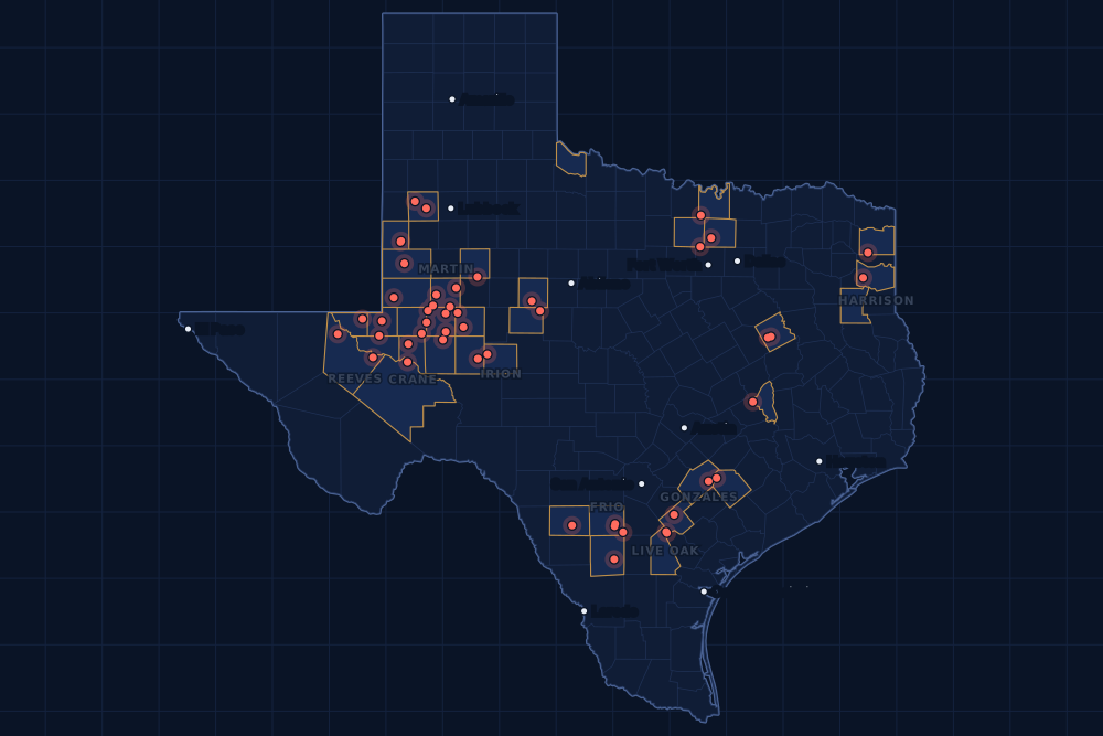
This address always shows the newest seven days. Follow by feed (Atom) · Earlier weeks
Counties and operators
Who drills, and where
Each county links to its Well Watch page, with its own map and every permit of the last two years. Each operator links to its page.
By county
- 1Midland County16
- 2Martin County9
- 3Glasscock County6
- 4Yoakum County6
- 5Karnes County5
- 6Reagan County5
- 7Ector County4
- 8Frio County4
- 9Crane County3
- 10Gonzales County3
- 11Harrison County3
- 12Irion County3
- 13Live Oak County3
- 14Reeves County3
- 15Borden County2
And 21 more counties with fewer, in the list below.
By operator
- 1Diamondback E&P LLC18
- 2Crescent Energy Operating, LLC5
- 3Discovery Natural Resources LLC5
- 4FW Eagle Ford I, LLC5
- 5Silver Hill Energy Operating LLC5
- 6Bta Oil Producers, LLC4
- 7Occidental Permian Ltd.4
- 8Pioneer Natural Res. USA, Inc.4
- 9Blackbeard Operating, LLC3
- 10Burlington Resources O & G Co LP3
- 11Chevron U. S. A. Inc.3
- 12Hilcorp Energy Company3
- 13Rfe Operating, LLC3
- 14Triple Crown Resources, LLC3
- 15BPX Operating Company2
And 26 more operators with fewer.
Register · November 7–13, 2026
Every permit, newest first
As the state files them: the lease and well, the operator, the kind of permit and the depth. “On the map” opens the county's live map at the well's spot.
Friday, November 1331 permits
- Andrews CountyState of Texas -T-, well 4Olsen Energy Inc. · recompletion · vertical · 10,272 ftPermit 0920060 · API 42-003-07191On the map
- Borden CountyPixie Unit B 35-47, well 5MHSurge Operating, LLC · new drill · horizontal · 9,000 ftPermit 0920052 · API 42-033-32887On the map
- Brazos CountyHunter Ef Three, well H 03GHMagnolia Oil & Gas Operating LLC · new drill · horizontal · 8,500 ftPermit 0919984 · API 42-041-32687On the map
- Cass CountySalmon, well 1HRose City Resources, LLC · new drill · horizontal · 13,000 ftPermit 0919977 · API 42-067-30989On the map
- Cooke CountyKnight, well 1DOleum Partners, LLC · new drill · vertical · 12,500 ftPermit 0919853 · API 42-097-34826On the map
- Freestone CountyCurry Gas Unit, well 8Hilcorp Energy Company · recompletion · vertical · 12,540 ftPermit 0919985 · API 42-161-33065On the map
- Frio CountyDouble Ringer 101HZ, well 101HZJavelin Energy Partners Mgmt LLC · new drill · horizontal · 14,000 ftPermit 0919737 · API 42-163-34454On the map
- Frio CountyBlazing Saddles, well A111VWFormentera Operations LLC · new drill · vertical · 5,800 ftPermit 0920039 · API 42-163-34460On the map
- Gonzales CountyCinco Ranch E, well 3HFW Eagle Ford I, LLC · new drill · horizontal · 14,500 ftPermit 0919916 · API 42-177-34873On the map
- Hockley CountyLawson, well 1HBeryl Oil and Gas, LP · new drill · horizontal · 5,000 ftPermit 0919226 · API 42-219-37586On the map
- Irion CountyAntelope Draw Bz S01, well 3HTriple Crown Resources, LLC · new drill · horizontal · 9,000 ftPermit 0920077 · API 42-235-36807On the map
- Irion CountyAntelope Draw Bz S01, well 2HTriple Crown Resources, LLC · new drill · horizontal · 9,000 ftPermit 0920076 · API 42-235-36806On the map
- Irion CountyAntelope Draw Bz S01, well 1HTriple Crown Resources, LLC · new drill · horizontal · 9,000 ftPermit 0920075 · API 42-235-36805On the map
- Karnes CountyMargaret Unit 2-PETERSON C, well 101HSilver Hill Energy Operating LLC · new drill · horizontal · 12,500 ftPermit 0919959 · API 42-255-38496On the map
- Karnes CountyMargaret Unit 2-PETERSON C, well 002HSilver Hill Energy Operating LLC · new drill · horizontal · 12,500 ftPermit 0919958 · API 42-255-38495On the map
- La Salle CountyBrown Trusts-Bd Sa 6, well 6HBPX Operating Company · new drill · horizontal · 11,800 ftPermit 0919719 · API 42-283-37969On the map
- La Salle CountyBrown Trusts-Bd Sa 5, well 5HBPX Operating Company · new drill · horizontal · 11,800 ftPermit 0919703 · API 42-283-37968On the map
- Martin CountyAtlas 54-62 Unit 2, well 4WADiamondback E&P LLC · new drill · horizontal · 11,000 ftPermit 0920029 · API 42-317-47643On the map
- Martin CountyAtlas 54-62 Unit 2, well 4LSDiamondback E&P LLC · new drill · horizontal · 11,000 ftPermit 0920028 · API 42-317-47642On the map
- Midland CountyCmc Sunflower Jm Unit, well 2253JMChevron U. S. A. Inc. · new drill · horizontal · 9,107 ftPermit 0920015 · API 42-329-48673On the map
- Midland CountyCmc Sunflower Jm Unit, well 2252JMChevron U. S. A. Inc. · new drill · horizontal · 9,107 ftPermit 0920014 · API 42-329-48672On the map
- Midland CountyCmc Sunflower Jm Unit, well 2251JMChevron U. S. A. Inc. · new drill · horizontal · 9,107 ftPermit 0920013 · API 42-329-48671On the map
- Upton CountyNeal-Hirsch 20N, well 14HPioneer Natural Res. USA, Inc. · new drill · horizontal · 10,819 ftPermit 0919235 · API 42-461-43829On the map
- Upton CountyNeal-Hirsch 20M, well 13HPioneer Natural Res. USA, Inc. · new drill · horizontal · 10,819 ftPermit 0919234 · API 42-461-43828On the map
- Winkler CountySealy Ranch, well 6903HHalcon Operating Co., Inc. · new drill · horizontal · 13,000 ftPermit 0919639 · API 42-495-35262On the map
- Yoakum CountyRusty Crane 604, well 5HRiley Permian Operating Co, LLC · new drill · horizontal · 9,000 ftPermit 0920043 · API 42-501-37747No location yet
- Yoakum CountyRusty Crane 604, well 4HRiley Permian Operating Co, LLC · new drill · horizontal · 9,000 ftPermit 0920042 · API 42-501-37746No location yet
- Yoakum CountyBennett Ranch Unit, well 4368Occidental Permian Ltd. · recompletion · horizontal · 5,700 ftPermit 0920056 · API 42-501-35664On the map
- Yoakum CountyBennett Ranch Unit, well 4347Occidental Permian Ltd. · recompletion · horizontal · 5,700 ftPermit 0920058 · API 42-501-34865On the map
- Yoakum CountyBennett Ranch Unit, well 3421Occidental Permian Ltd. · recompletion · horizontal · 5,700 ftPermit 0920044 · API 42-501-36863On the map
- Yoakum CountyBennett Ranch Unit, well 3340Occidental Permian Ltd. · recompletion · horizontal · 5,700 ftPermit 0920055 · API 42-501-31023On the map
Thursday, November 1235 permits
- Borden CountyPixie Unit A 35-47, well 4MHSurge Operating, LLC · new drill · horizontal · 9,000 ftPermit 0920010 · API 42-033-32886On the map
- Coke CountySallie Odom 'F', well 101L.c.s. Production Company · re-entry · vertical · 5,700 ftPermit 0918557 · API 42-081-31630On the map
- Denton CountySexton 5 (Aw), well 5HBKV Barnett II, LLC · new drill · horizontal · 17,541 ftPermit 0919879 · API 42-121-34671On the map
- Ector CountyMillie B 43-7 D, well 4BNDiamondback E&P LLC · new drill · horizontal · 13,000 ftPermit 0919230 · API 42-135-44336On the map
- Ector CountyMillie B 43-7 C, well 3BNDiamondback E&P LLC · new drill · horizontal · 13,000 ftPermit 0919229 · API 42-135-44335On the map
- Ector CountyMillie B 43-7 B, well 2BNDiamondback E&P LLC · new drill · horizontal · 13,000 ftPermit 0919228 · API 42-135-44334On the map
- Ector CountyMillie B 43-7 A, well 1BNDiamondback E&P LLC · new drill · horizontal · 13,000 ftPermit 0919227 · API 42-135-44333On the map
- Gaines CountySeminole San Andres Unit, well 4126OXY USA Inc. · recompletion · vertical · 5,800 ftPermit 0920008 · API 42-165-31993On the map
- Glasscock CountyCole E, well 5ACrescent Energy Operating, LLC · new drill · horizontal · 9,000 ftPermit 0919291 · API 42-173-39624On the map
- Glasscock CountyCole D, well 4LSCrescent Energy Operating, LLC · new drill · horizontal · 9,000 ftPermit 0919290 · API 42-173-39623On the map
- Glasscock CountyCole C, well 3ACrescent Energy Operating, LLC · new drill · horizontal · 9,000 ftPermit 0919289 · API 42-173-39622On the map
- Glasscock CountyCole B, well 2LSCrescent Energy Operating, LLC · new drill · horizontal · 9,000 ftPermit 0919288 · API 42-173-39621On the map
- Glasscock CountyCole A, well 1BCrescent Energy Operating, LLC · new drill · horizontal · 9,000 ftPermit 0919287 · API 42-173-39620On the map
- Gonzales CountyCinco J Ranch X B, well 2UHFW Eagle Ford I, LLC · new drill · horizontal · 14,500 ftPermit 0919911 · API 42-177-34872On the map
- Hardeman CountyParker, well 1Corlena Oil Company · new drill · vertical · 8,500 ftPermit 0919818 · API 42-197-31818No location yet
- Hockley CountyStinger, well 2Texland Petroleum, L.P. · new drill · vertical · 6,800 ftPermit 0920027 · API 42-219-37594On the map
- Karnes CountyMargaret Unit 1-PETERSON E, well 201HSilver Hill Energy Operating LLC · new drill · horizontal · 11,450 ftPermit 0919961 · API 42-255-38497On the map
- Karnes CountyMargaret Unit 1-PETERSON D, well 003HSilver Hill Energy Operating LLC · new drill · horizontal · 12,500 ftPermit 0919967 · API 42-255-38499On the map
- Karnes CountyMargaret Unit 1, well 102HSilver Hill Energy Operating LLC · new drill · horizontal · 12,500 ftPermit 0919966 · API 42-255-38498On the map
- Live Oak CountyGonzales Unit, well 3Burlington Resources O & G Co LP · new drill · horizontal · 17,500 ftPermit 0919940 · API 42-297-36612On the map
- Live Oak CountyGonzales Unit, well 2Burlington Resources O & G Co LP · new drill · horizontal · 17,500 ftPermit 0919939 · API 42-297-36611On the map
- Martin CountyKimberly, well U 1WBDiamondback E&P LLC · new drill · horizontal · 11,000 ftPermit 0918697 · API 42-317-47496On the map
- Martin CountyCaza Pato 21910 D 25-36, well 04HBta Oil Producers, LLC · new drill · horizontal · 11,500 ftPermit 0919988 · API 42-317-47639On the map
- Martin CountyCaza Pato 21910 C 25-36, well 03HBta Oil Producers, LLC · new drill · horizontal · 11,500 ftPermit 0919987 · API 42-317-47638On the map
- Martin CountyCaza Pato 21910 B 25-36, well 02HBta Oil Producers, LLC · new drill · horizontal · 11,500 ftPermit 0919986 · API 42-317-47637On the map
- Martin CountyCaza Pato 21910 A 25-36, well 01HBta Oil Producers, LLC · new drill · horizontal · 11,500 ftPermit 0919976 · API 42-317-47634On the map
- Midland CountyGrand Prix 28-09 D, well 1WBDiamondback E&P LLC · new drill · horizontal · 11,000 ftPermit 0919481 · API 42-329-48635On the map
- Midland CountyGrand Prix 28-09 B, well 1LSDiamondback E&P LLC · new drill · horizontal · 11,000 ftPermit 0919479 · API 42-329-48632On the map
- Reeves CountyRoundup 13/16/13 C, well W101NMMewbourne Oil Company · new drill · horizontal · 11,000 ftPermit 0920032 · API 42-389-42391On the map
- Reeves CountyRoundup 13/16/12 B, well W101PNMewbourne Oil Company · new drill · horizontal · 11,000 ftPermit 0920031 · API 42-389-42390On the map
- Reeves CountySoda Popinski 27, well 4911UGreenlake Energy Operating, LLC · new drill · horizontal · 12,400 ftPermit 0919865 · API 42-389-42379On the map
- Rusk CountyHelvenston E Hs (Aw), well 5HSabine Energy Inc. · new drill · horizontal · 12,000 ftPermit 0919903 · API 42-401-35525No location yet
- Ward CountyVulcan 2-3 H, well 303HRMCM Operating, LLC · new drill · horizontal · 11,000 ftPermit 0920106 · API 42-475-39129No location yet
- Wise CountyIndian Creek R 6 (Aw), well 6HBKV North Texas, LLC · new drill · horizontal · 14,482 ftPermit 0919163 · API 42-497-38169On the map
- Zavala CountySouthwest Star, well 1HGulftex Energy, LLC · new drill · horizontal · 10,000 ftPermit 0919584 · API 42-507-33583On the map
Tuesday, November 1026 permits
- Crane CountyWaddell Tr Ab 4M, well 4148HBlackbeard Operating, LLC · new drill · horizontal · 7,999 ftPermit 0919862 · API 42-103-37875On the map
- Crane CountyWaddell Tr Ab 3M2, well 4147HBlackbeard Operating, LLC · new drill · horizontal · 7,999 ftPermit 0919866 · API 42-103-37876On the map
- Crane CountyWaddell Tr Ab 3M1, well 4146HBlackbeard Operating, LLC · new drill · horizontal · 7,999 ftPermit 0919867 · API 42-103-37877On the map
- Frio CountyDouble Ringer 101HB, well 101HBJavelin Energy Partners Mgmt LLC · new drill · horizontal · 14,000 ftPermit 0919720 · API 42-163-34451On the map
- Frio CountySendero-Unit-B, well S736HFormentera Operations LLC · new drill · horizontal · 10,500 ftPermit 0919946 · API 42-163-34459On the map
- Glasscock CountyDeebo, well 1HBlack Swan Opco, LLC · new drill · horizontal · 10,600 ftPermit 0919157 · API 42-173-39601On the map
- Harrison CountyHagen Cv 1 (Aw), well 1HRfe Operating, LLC · new drill · horizontal · 12,100 ftPermit 0919447 · API 42-203-35837On the map
- Lavaca CountyMccreary Sa B, well 2UHFW Eagle Ford I, LLC · new drill · horizontal · 14,500 ftPermit 0919899 · API 42-285-34386On the map
- Lavaca CountyMccreary Sa A, well 1UHFW Eagle Ford I, LLC · new drill · horizontal · 14,500 ftPermit 0919895 · API 42-285-34385On the map
- Live Oak CountyArnold Unit B, well 1Burlington Resources O & G Co LP · recompletion · horizontal · 12,841 ftPermit 0919957 · API 42-297-35087On the map
- Loving CountyDark Knight State C, well 741HPdeh LLC · new drill · horizontal · 11,000 ftPermit 0919225 · API 42-301-38023On the map
- Loving CountyDark Knight State A, well 761HPdeh LLC · new drill · horizontal · 10,500 ftPermit 0919211 · API 42-301-38021On the map
- Martin CountyScharbauer-Curtis 20N, well 2014HUPioneer Natural Res. USA, Inc. · new drill · horizontal · 11,298 ftPermit 0919956 · API 42-317-47636On the map
- Martin CountyScharbauer Ranch, well 2013HUPioneer Natural Res. USA, Inc. · new drill · horizontal · 11,298 ftPermit 0919953 · API 42-317-47635On the map
- Midland CountyFasken Tr 7X, well 115HDOvintiv USA Inc. · new drill · horizontal · 11,000 ftPermit 0919075 · API 42-329-48618On the map
- Midland CountyFasken Tr 7X, well 114HJOvintiv USA Inc. · new drill · horizontal · 11,000 ftPermit 0919073 · API 42-329-48617On the map
- Midland CountyHulk Hogan 12-48 F, well 3JMDiamondback E&P LLC · new drill · horizontal · 11,000 ftPermit 0919021 · API 42-329-48613On the map
- Midland CountyHulk Hogan 12-48 E, well 3WBDiamondback E&P LLC · new drill · horizontal · 11,000 ftPermit 0919018 · API 42-329-48611On the map
- Midland CountyHulk Hogan 12-48 E, well 3LSDiamondback E&P LLC · new drill · horizontal · 11,000 ftPermit 0919020 · API 42-329-48612On the map
- Midland CountyHulk Hogan 12-48 E, well 2MSDiamondback E&P LLC · new drill · horizontal · 11,000 ftPermit 0919015 · API 42-329-48610On the map
- Midland CountyHulk Hogan 12-48 D, well 2WDDiamondback E&P LLC · new drill · horizontal · 11,000 ftPermit 0919034 · API 42-329-48614On the map
- Midland CountyHulk Hogan 12-48 D, well 2WADiamondback E&P LLC · new drill · horizontal · 11,000 ftPermit 0919004 · API 42-329-48608On the map
- Midland CountyHulk Hogan 12-48 D, well 2JMDiamondback E&P LLC · new drill · horizontal · 11,000 ftPermit 0919013 · API 42-329-48609On the map
- Midland CountyHulk Hogan 12-38 C, well 2WBDiamondback E&P LLC · new drill · horizontal · 11,000 ftPermit 0918999 · API 42-329-48607On the map
- Midland CountyHulk Hogan 12-38 C, well 2LSDiamondback E&P LLC · new drill · horizontal · 11,000 ftPermit 0918998 · API 42-329-48606On the map
- Winkler CountyCampbell, Seth, well 80Hilcorp Energy Company · recompletion · vertical · 5,850 ftPermit 0920009 · API 42-495-33532On the map
Monday, November 911 permits
- Freestone CountyRoper Gas Unit, well 7Hilcorp Energy Company · recompletion · vertical · 12,330 ftPermit 0919972 · API 42-161-34581On the map
- Gonzales CountyCinco J Ranch X A, well 1UHFW Eagle Ford I, LLC · new drill · horizontal · 14,500 ftPermit 0919906 · API 42-177-34871On the map
- Harrison CountyHagen Hvs 3 (Aw), well 3HRfe Operating, LLC · new drill · horizontal · 12,100 ftPermit 0919454 · API 42-203-35840On the map
- Harrison CountyHagen Hvs 2 (Aw), well 2HRfe Operating, LLC · new drill · horizontal · 12,100 ftPermit 0919450 · API 42-203-35839On the map
- Nolan CountyBridgford 102, well 1Per Operating LLC · recompletion · vertical · 7,400 ftPermit 0919636 · API 42-353-33696On the map
- Pecos CountyFitzgerald State, well 1Petx Operating LLC · recompletion · vertical · 5,050 ftPermit 0919968 · API 42-371-05666On the map
- Reagan CountyBullhead, well 0758LADiscovery Natural Resources LLC · new drill · horizontal · 8,500 ftPermit 0919965 · API 42-383-42542On the map
- Reagan CountyBullhead, well 0756MBDiscovery Natural Resources LLC · new drill · horizontal · 8,500 ftPermit 0919964 · API 42-383-42541On the map
- Reagan CountyBullhead, well 0753MBDiscovery Natural Resources LLC · new drill · horizontal · 8,500 ftPermit 0919963 · API 42-383-42540On the map
- Reagan CountyBullhead, well 0748MBDiscovery Natural Resources LLC · new drill · horizontal · 8,500 ftPermit 0919955 · API 42-383-42538On the map
- Reagan CountyBullhead, well 0746MBDiscovery Natural Resources LLC · new drill · horizontal · 8,500 ftPermit 0919954 · API 42-383-42537On the map
Cancelled permits are left out. To look a permit up at the source, use the Railroad Commission's drilling permit query with its permit number.
Archive
Earlier weeks
Each finished week, Monday to Sunday, has its own page that does not change. The feed gets one entry per week.
- Nov 2–8, 2026164
- Oct 26 – Nov 1, 2026242
- Oct 19–25, 2026215
- Oct 12–18, 2026147
- Oct 5–11, 2026167
- Sep 28 – Oct 4, 2026156
- Sep 21–27, 2026194
- Sep 14–20, 2026167
- Sep 7–13, 2026133
- Aug 31 – Sep 6, 2026182
- Aug 24–30, 2026118
- Aug 17–23, 2026167
Every week since January 1, 2024 (149 weeks)
2026
- Aug 10–16198
- Aug 3–9186
- Jul 27 – Aug 2143
- Jul 20–26170
- Jul 13–19117
- Jul 6–12194
- Jun 29 – Jul 5114
- Jun 22–28175
- Jun 15–21186
- Jun 8–14187
- Jun 1–7154
- May 25–31158
- May 18–24197
- May 11–17182
- May 4–10190
- Apr 27 – May 3156
- Apr 20–26210
- Apr 13–19133
- Apr 6–12206
- Mar 30 – Apr 5129
- Mar 23–29159
- Mar 16–22167
- Mar 9–15166
- Mar 2–8140
- Feb 23 – Mar 1181
- Feb 16–22141
- Feb 9–15133
- Feb 2–8124
- Jan 26 – Feb 1126
- Jan 19–25189
- Jan 12–18280
- Jan 5–11129
2025
- Dec 29 – Jan 4, 202656
- Dec 22–2846
- Dec 15–21154
- Dec 8–14119
- Dec 1–7128
- Nov 24–3061
- Nov 17–23140
- Nov 10–1698
- Nov 3–9107
- Oct 27 – Nov 2137
- Oct 20–26145
- Oct 13–19173
- Oct 6–12206
- Sep 29 – Oct 5124
- Sep 22–28141
- Sep 15–21165
- Sep 8–14127
- Sep 1–7105
- Aug 25–31145
- Aug 18–24115
- Aug 11–17140
- Aug 4–10131
- Jul 28 – Aug 3134
- Jul 21–27151
- Jul 14–20151
- Jul 7–13148
- Jun 30 – Jul 6148
- Jun 23–29167
- Jun 16–22118
- Jun 9–15115
- Jun 2–8147
- May 26 – Jun 190
- May 19–25148
- May 12–18120
- May 5–11114
- Apr 28 – May 4135
- Apr 21–27182
- Apr 14–20115
- Apr 7–13197
- Mar 31 – Apr 6194
- Mar 24–30170
- Mar 17–23189
- Mar 10–16177
- Mar 3–9141
- Feb 24 – Mar 2172
- Feb 17–23145
- Feb 10–16170
- Feb 3–9167
- Jan 27 – Feb 2149
- Jan 20–26158
- Jan 13–19176
- Jan 6–12140
2024
- Dec 30 – Jan 5, 202597
- Dec 23–295
- Dec 16–22168
- Dec 9–15202
- Dec 2–8182
- Nov 25 – Dec 189
- Nov 18–24189
- Nov 11–17145
- Nov 4–10152
- Oct 28 – Nov 3134
- Oct 21–27163
- Oct 14–20147
- Oct 7–13114
- Sep 30 – Oct 6138
- Sep 23–29133
- Sep 16–22175
- Sep 9–15144
- Sep 2–8138
- Aug 26 – Sep 1177
- Aug 19–25207
- Aug 12–18186
- Aug 5–11145
- Jul 29 – Aug 4191
- Jul 22–28174
- Jul 15–21164
- Jul 8–14205
- Jul 1–7106
- Jun 24–30183
- Jun 17–23192
- Jun 10–16161
- Jun 3–9176
- May 27 – Jun 2135
- May 20–26223
- May 13–19169
- May 6–12155
- Apr 29 – May 5191
- Apr 22–28224
- Apr 15–21200
- Apr 8–14157
- Apr 1–7149
- Mar 25–31102
- Mar 18–24130
- Mar 11–17228
- Mar 4–10178
- Feb 26 – Mar 3187
- Feb 19–25164
- Feb 12–18190
- Feb 5–11137
- Jan 29 – Feb 4177
- Jan 22–28172
- Jan 15–21107
- Jan 8–14251
- Jan 1–7148
FAQ
Questions people ask
What is a drilling permit?
Permission from the Railroad Commission of Texas to drill a well, or to re-enter or deepen an old one, at a stated spot and to a stated depth. An operator files for it before the rig comes; it lasts two years. Many permitted wells are drilled within months, some never are.
Why does the week end on this day?
The page shows the seven days through the newest issue date on file, November 13, 2026. The state publishes its permit file every night, and a day's permits can keep arriving for a few days, so the newest days fill in.
Some permits are not on the map. Why?
The map draws a permit at the well's surface location as the state files it. A new permit's location can take a few days to reach the state's files; until then it is listed here but not drawn.
Does a new permit near my land mean I will be paid?
No. A permit says where a well may be drilled, not whose minerals it will produce or who is paid. That depends on your lease, the unit the well is pooled in and the division order. If a well is drilled on or next to your tract, watch for a division order from the operator.
Can I get these by email or in a feed?
Yes. The feed on this page has one entry for each finished week, for any feed reader. For one county, an abstract or a lease, Texas Well Watch sends one email a week when the state files something new there; it is free with an account.
Sources
- Railroad Commission of Texas, drilling permit master and trailer, daily file (with latitudes and longitudes)www.rrc.texas.gov/resource-center/research/data-sets-available-for-download/ · loaded every night; newest permit on file November 13, 2026
- Railroad Commission of Texas, drilling permit query (one permit at the source)webapps.rrc.texas.gov/DP/initializePublicQueryAction.do · linked, not read
- US Census Bureau, cartographic boundary files (county lines), through the us-atlas package 3.0.1www.census.gov/geographies/mapping-files/time-series/geo/cartographic-boundary.html · built into the site with its well maps
- GeoNames, towns and their points (CC BY 4.0)www.geonames.org/ · built into the site with its town pages